Weather and Climate Chapter 3 Weather Climate l


 and the")


 l Mediterranean Climate – hot, dry summer and cool, moist winter")


 before")
")


- Slides: 85
Weather and Climate Chapter 3
Weather & Climate l l Climate is what you expect Weather is what you get
Weather l l weather – condition of atmosphere over a short time climate – weather over a long time – latitude affects climate – middle and high have distinct seasons l l l polar – cold all year tropics – warm all year temperature – measurement of heat
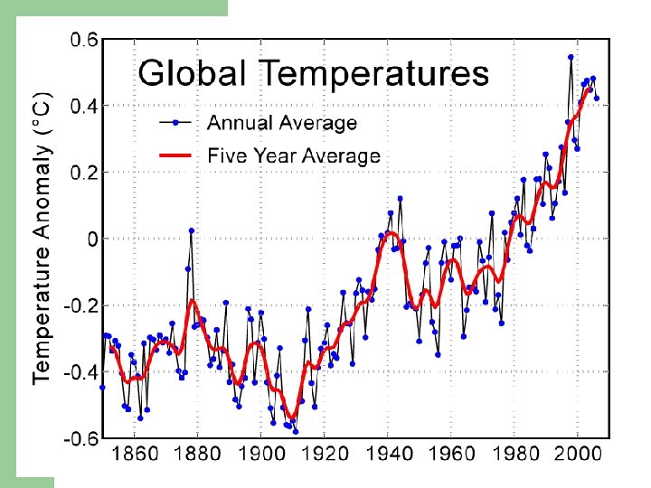
Weather l l greenhouse effect – atmosphere traps heat and keeps the planet warm global warming – increase in temperatures – – l caused by burning fossil fuels? natural? volcanoes? oceans? What might be the results of global warming?
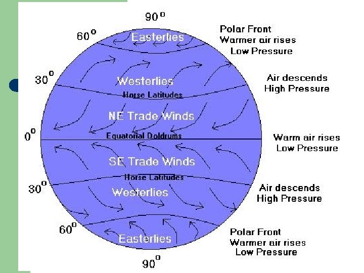
Atmospheric Pressure l l l The earth distributes the sun’s heat. This affects climate Example: elevation = less air = less pressure = colder low pressure – air moves higher = storms, cyclones, monsoons high pressure – air sinks = dry There are 4 major air pressure zones: DIAGRAM ON PAGE 43 – – equatorial lows subtropical highs subpolar lows polar highs
Global Wind Effects l l l Wind flows from high to low pressure Winds maintain balance of heat and energy. prevailing winds – constant blowing in the same direction trade winds – blow towards the equator – NE and SE toward equator doldrums – wind/lack of wind – along the equator westerly winds – in the middle latitude – west to east
A diagram illustrating Columbus? first route to the New World (in red) and the trade winds he used to get there (in black). Columbus return trip was powered by the Westerlies.
Triangular Trade
Wind & Weather l l front – hot air meets cold air – Virginia Beach jet stream – “rivers” of air in the upper atmosphere
Oceans & Currents l l l water cools slower than land Virginia Beach vs Richmond (influence of ocean) ocean currents move around the globe – – l Gulf Stream – warm water current off the east coast – l page 52 -53 – hot to cold and cold to hot currents move the sun’s heat influences the climate of W. Europe California Current – a cool current off of the west coast of the US
Weather Factors
Precipitation l l evaporation – water changes from liquid to gas humidity – amount of water vapor in the air – l l the higher the temp. = higher ability to hold water condensation – when air cannot hold more it condenses gas to liquid - fog, dew, frost, cloud – will fall as snow, rain, hail, sleet
Elevation and Mountain Effects l l l orographic precipitation – moist air rises up the side of a mountain, condenses, then falls as precipitation windward – wet side of mountain – gets the wind leeward – dry side of the mountain – – where desert would form called the rain shadow
Storms l l l hot air rises and mixes with cold air tornadoes – most of these occur in the US hurricanes – over 74 mph – start over Africa/Caribbean Sea – l travel to the west due to the winds – trade winds typhoons – western pacific – same type of storm as hurricanes
Tornadoes
Tornado Alley – Central US/Great Plains
Hurricanes & Typhoons
Weather Systems l Read “Weather Systems”
Climate and Vegetation Patterns
Tropical Climates l ecosystem – a community of plants, animals, soil, climate – l tropical humid (wet) – rains all year – hot all year – l the most diverse are in the hot regions convectional rainfall – rains same time every day – rainsevaporates-rains –hot air tropical wet and dry – (tropical savanna) – 3 seasons = wet, dry, fire – – affected by monsoon winds savanna – savanna grasslands – depends on wind direction
Dry Climates l arid – dry – can have constant high pressure – – – l located about 30º north and south of the equator less than 10” of rain per year rain shadow interior of continents dry coastal areas – cold currents keep air stable (coast of Chili) semiarid – 10 -20” of rain – – – transition between arid and humid regions grasses grow well (Great Plains) used for growing grains
Mid-Latitude Climates (temperate) l Mediterranean Climate – hot, dry summer and cool, moist winter – – l Humid Subtropical Climate – hot, wet summer and cool winter – – – l eastern side of continent – where there is warm water – example: Virginia Beach vegetation includes deciduous forest – broadleaf tress where leaves die coniferous forest – tress are cone bearing with needles Marine West Coast – mild all year – influenced by the ocean – – l Mediterranean Sea, California, Spain, Chili, Australia usually west coast of a continent Mediterranean scrub woodland vegetation short trees and shrubs on the west coasts in the upper middle latitudes – W. Europe, NW US and Canada can support dense coniferous forests – called “Temperate Rainforests” Humid Continental – hot summer, cold winter – interior and east coast of upper middle latitude continents
High Latitudes Climates l subarctic – long, cold winter and short warm summer – – – l generally above 50º north -- far north of Asia, Europe and North America supports vast evergreen forests – these are called boreal forests Skagway = 200 year old trees tundra – coastal areas of high latitudes – – – temperature is above freezing only in the short summer permafrost – permanently frozen soil In the short summer, top layer turns to bog, swamp, marsh since water cannot seep into the frozen ground – buildings collapse
Highlands Climates l highlands climates – on the side of mountains – – changes as you go higher in elevation Ex. Mt. Kilimanjaro in Africa
l READ CASE STUDIES – “THE POLES” – PAGES 58 -59. l Complete climate chart
Landforms, Water, and Natural Resources Chapter 4
Chapter 4. 1: Landforms
Forces below the earth l l Geology – the study of the earth’s physical structures and the processes that have created them Parts of the earth – – Inner core: center of the earth Outer core: dense liquid material Mantle: liquid rock (magma); becomes lava when it breaks through the surface Crust: surface (lithosphere)
The Earth’s Layers
Internal Forces l l l plate tectonics: crust is made up of moving plates continental drift: plates are moving by convection along the magma Volcanoes: happen along the plate boundaries Earthquakes: happen along the plate boundaries Pangea: super continent – rock formations and fossils line up
Pangea Watch how the continents move to form the Earth as we see it today.
Plate Movement l l Spreading: plates spread apart, forming a diverging plate boundary; such areas are likely to have a rift valley, earthquakes, or volcanic action (ex. Mid. Atlantic Ridge, rift valley on land – Iceland, Africa) Collision: plates collide & mountains form (ex. Himalayas formed millions of years ago when the Indo-Australian plate crashed into the Eurasian Plate at a rate of about two inches per year) Subduction: plates dive under one another (ex. Andes Mountains formed over millions of years as the Nazca Plate slid under the South American plate) Faulting: plates slip past one another (ex. California San Andreas Fault)
Abyssal Plain l l Abyssal Plain: area of ocean floor where rocks gradually sink; they have no supporting heat below; these are the world’s flattest and smoothest regions Continental Shelf – the shallow land around a continent
Continental Shelf
When Plates Collide… l l l under the ocean – 1 dives and a trench is formed – diving plate generates heat – this may cause a volcano -- mountains / islands are formed mountains are formed – Himalayas, Alps -folds – like a towel – a head on collision -faults – cracks in the earth plates moving latterly – San Andreas Fault -pressure builds and has to go some where
San Andreas Fault
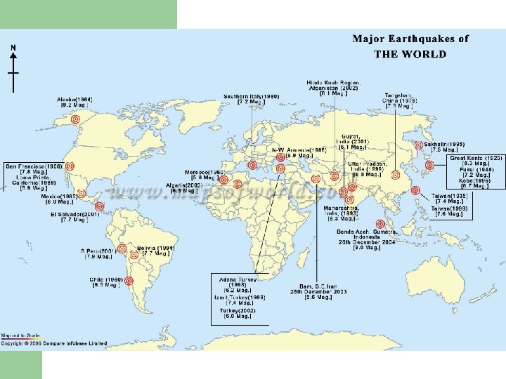
Some Quake and Dirty Facts… What's the world's largest earthquake? 9. 5 magnitude in Chile on May 22, 1960 What's the U. S. ' largest earthquake? 9. 2 magnitude in Prince William Sound, Alaska, on March 27, 1964. The earthquake and ensuing tsunami killed 125 people (tsunami 110, earthquake 15), and caused about $311 million in property loss. What's the world's most destructive earthquake? 830, 000 died in Shansi, China, on January 23, 1556. Which state has the most damaging earthquakes? California.
Some Quake and Dirty Facts… When will California slide into the ocean? Hey, are you from the East Coast? There is no scientific reason for California to fall into the ocean. Is Los Angeles moving closer to San Francisco? Angelinos will be barbecuing alongside latte-sipping City folks sooner than you can say plastic surgery. Due to motions of the plates, L. A. is gradually creeping northward and will eventually be a suburb of San Francisco. I want to move to a place that doesn't have earthquakes. Where can I go? Grab a seal blubber-lined parka and move to Antarctica (which has the fewest amount of earthquakes of any continent), or stay put: Small earthquakes can occur anywhere in the world.
Some Quake and Dirty Facts… Where can I buy a Richter scale? At Safeway - next to the Weight Watchers scale. The Richter scale is not a physical device, but a mathematical formula. How many earthquakes happen every month? Day? Minute? Per year: Approximately 1, 000, including those too small to be felt. Per month: Approximately 80, 000 Per day: Approximately 2, 600 Per minute: Approximately 2 Per second: Approximately one earthquake every 30 seconds. What was the first instrument to record an earthquake? In 132 A. D. , Chinese philosopher Chang Heng invented the first seismoscope, a large urn decorated with dragonheads and gapingmouthed frogs.
The Himalayas
l The 6, 000 km plus journey of the India landmass (Indian Plate) before its collision with Asia (Eurasian Plate) about 40 to 50 million years ago.
Weathering and Erosion l Weathering: break down of rock; decay of rock (actually breaking) – – new soil is formed frost wedging – splitting of rock A rock in southern Iceland fragmented by freeze-thaw action.
Weathering and Erosion l Chemical Weathering: dissolves rock – Caves are formed Limestone – Erosion: wind, water, glaciers – l Movement of weathered material from place to place l Important for life, soil
Water, Waves, and Wind l Water: #1 type of erosion – – l l no plants = more erosion forms V shaped valleys, river valleys, canyons Waves: erosion in Virginia Beach, North Carolina Wind: sand is moved by wind
Jockey’s Ridge
Dust Bowl Dust storms in Texas, 1935 Buried machinery in barn lot. Dallas, South Dakota, May
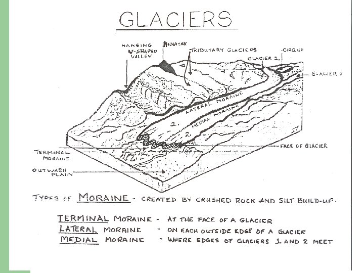
The Power of Ice l l acts like a bulldozer most of Greenland Antarctica are covered by ice – up to 2 miles found in the high mountains – even on the equator forms U shaped valleys (river=V)
Glaciers
Shapes on the Land l l l First: landforms formed by tectonic forces by volcanoes, earthquakes, folding, faulting Second: landforms formed by erosion forms a plateau – an elevated flat land that rises sharply above nearby land at least on 1 side Third: landformed by sediment deposited by wind, water, glaciers sand dune, flood plain, delta
Alluvial Fan-shaped deposit of mud and gravel often found along the bases of mountains Most regions have many types of landforms. The location, size and shape of landforms affect where people live and their transportation.
Alluvial Fan: Death Valley
Chapter 4. 2: The Hydrosphere
Water on Earth l l Only 3 percent of the water on earth is fresh Most fresh water is in the ice Desalination: removing salt from water Hydrologic Cycle: movement of water through the hydrosphere
Hydrologic Cycle
Surface Waters l l As precipitation falls on continents and islands, it flows down hills and mountains toward the lowlands and coasts. Headwaters: smallest streams Tributaries: any stream or river that flows into a larger stream or river watershed/drainage basin – region drained by a river
Keep In Mind… WATER HEATS AND COOLS SLOWER THAN LAND
Surface Water cont… l Estuary: forms where a river meets an inlet, or small arm of a sea (wide mouth of a river) (ex. Chesapeake Bay, Thames River in England, etc. )
Groundwater l l Groundwater: water found beneath the surface Water table: level below the surface that are filled with water – – Depends on amount of rainfall Can cause sinkholes if all water is removed
Floods l l Floods: caused by sudden heavy rains or snow melt; they erode the land destroy vegetation Floodplains are fertile and good for farming
Chapter 4. 3: Natural Resources
Soil and Forests l l These are renewable resources Soil: takes a long time to form – – l l l includes rocky sediment and organic material climate affects weather which affects soil Humus: mix of bacteria, insects, worms that breakdown plants and animals Leaching: soil is less fertile due to rainwater washing out minerals and nutrients Similar climates = similar vegetation
Sustaining Soil Resources l l l Contour plowing: farming at an angle; works across a hill rather than up and down the hill; stops erosion Soil Exhaustion: caused by same crop being planted in the same spot every year Rotation: planting different crops in the same spot Irrigation: artificial watering soil salinization: salt builds up in the soil – – soil has salt in it and evaporation leaves it behind flooding helps this problem
Farming with row patterns nearly level around the hill—not up and down hill. Crop row ridges built by tilling and/or planting on the contour create hundreds of small dams. These ridges or dams slow water flow and increase infiltration which reduces erosion.
Forests l l Deforestation: destruction/loss of forests – clearing the land for farming or ranching Reforestation: replanting trees What products do we get from plants and trees?
Deforestation
Deforestation for agriculture in Benambra, Australia DE FOREST Jungle burned for agriculture in southern Mexico. ATION
Air l Smog: smoke and fog form chemicals in the air – leads to pollution – L. A. , Mexico City l Acid Rain: chemicals in polluted air combine with water vapor and form acid rain – destroys trees – pollutes – eats away stone and natural rock formations – Causes industrial pollution – acid producing agents in the ocean and volcanic activity are among the causes of acid rain. – Countries: Germany, China, US, Scandinavia, Canada l Global Warming – trapped heat in the atmosphere is causing a rise in temperatures
Smog over Beijing A comparison of Beijing air on a day after rain and a sunny but smoggy day
The effects of acid rain in the Jizera Mountains of the Czech Republic
Water l l Aqueducts: bring water to the cities Aquifers: ground water is mined – – l Wells ground water is usually renewable Fossil water: ground water in the desert that is used for irrigation – not being replaced
Pont du Gard, France, a Roman aqueduct built circa 19 BC. It is one of France's top tourist attractions and a World Heritage Site. Aqueducts The Central Arizona Project Aqueduct, the largest and most expensive aqueduct system ever constructed in the United States.
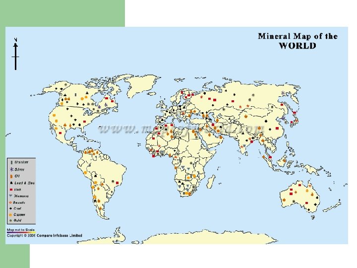
Mineral Resources l Uses of minerals – – l We make things from minerals Ore = mineral bearing rock Mineral Recycling – Usually metals like aluminum Switzerland Japan have no resources but are very wealthy.
Energy Resources l l l Fossil fuels: energy resources formed from the remains of ancient plants and animals, including coal, natural gas, and petroleum Petrochemicals: certain products made from oil Geothermal energy: heat of earth’s interior
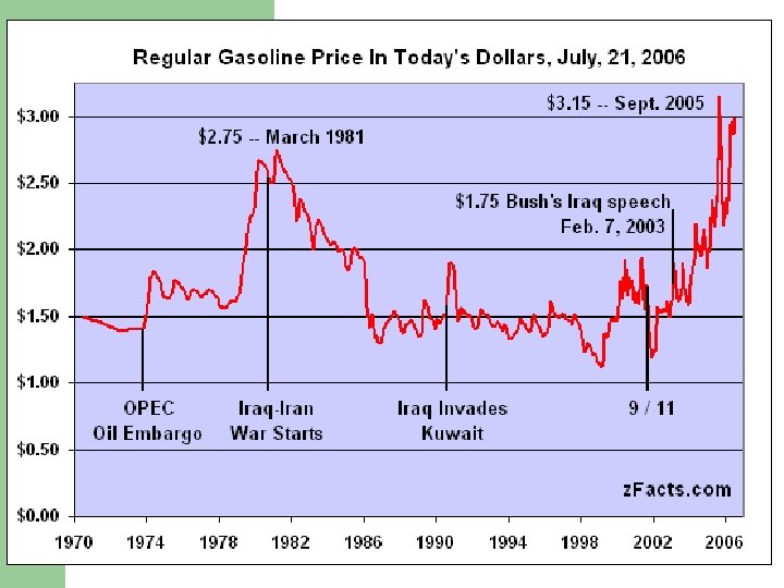
Who has the oil?
Who has the oil? l l l l In order of amount produced in 2004 (MMbbl/d = millions of barrels per day): Saudi Arabia (OPEC) - 10. 37 MMbbl/d Russia - 9. 27 MMbbl/d United States 1 - 8. 69 MMbbl/d Iran (OPEC) - 4. 09 MMbbl/d Mexico 1 - 3. 83 MMbbl/d China 1 - 3. 62 MMbbl/d Norway 1 - 3. 18 MMbbl/d Canada 1, 3 - 3. 14 MMbbl/d Venezuela (OPEC) 1 - 2. 86 MMbbl/d United Arab Emirates (OPEC) - 2. 76 MMbbl/d Kuwait (OPEC) - 2. 51 MMbbl/d Nigeria (OPEC) - 2. 51 MMbbl/d United Kingdom (Scotland) 1 - 2. 08 MMbbl/d Iraq (OPEC) 2 - 2. 03 MMbbl/d
Final Thought… Has the value of resources changed over time?