Water Movement Groundwater Oceans Sec 9 1 Water


")


 carves a channel into")


 Ø You will have two subgroups (bubbles). Each")


 Ø Ø Ø Four things effect porosity: 1. Vegetation 2. Rate of")


 A. Read in the textbook:")
 A. Read article. B. Answer")

- Slides: 46
Water! Movement, Groundwater, Oceans Sec 9. 1 Water Cycle and Stream Development Sec 9. 3 Lakes and Freshwater Wetlands Sec 10. 1 -10. 3 Groundwater Movement, Storage and Systems
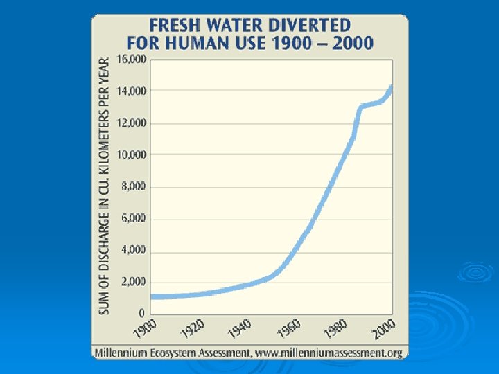
71% of Earth is water • 97% in the oceans • 3% is freshwater • There are no new sources of water on Earth. All water is being cycled!
Water Usage 70% - Irrigation 20% - Industry 10% - Cities & Residence
The Water Cycle Ø Read the article as a class. Ø Answer the questions #1 -5 in COMPLETE SENTENCES on the right hand side of your paper. Ø 10 minutes
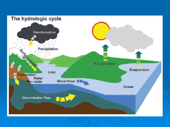
Global Water Cycle
Terms to define: Ø Precipitation- water falling to Earth (rain, snow, sleet or hail) Ø Evaporation- Water moving from Earth to the sky. Water changing from liquid to gas. Ø Transpiration-Water moving from PLANTS on Earth to the sky. Water changing from liquid to gas. Ø Condensation – form clouds and rain. Water changing from gas to liquid. Ø Percolation – water seeping into the ground.
Water Movement Certain conditions determine whether water will seep into the ground or stay on the surface. Ø GRADIENT/SLOPE-how steep an area is Ø POROSITY- the pores or spaces in the ground material Ø Ø First we will discuss water moving on the surface of the Earth.
Slope Ø If an area is not permeable to water AND has enough slope a stream/river will begin to form. Ø We measure slope of land using topographic maps!
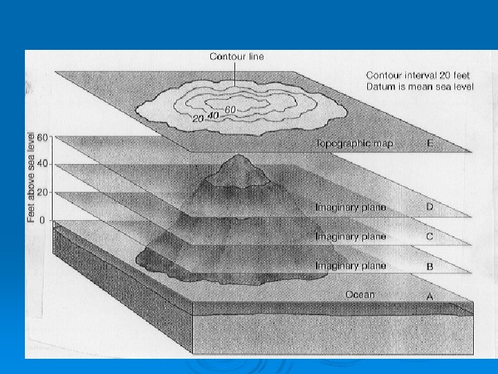
Topographical Maps Ø Show elevation and surface features, or topography, of the earth Ø Contour lines - lines used to connect areas of the same elevation Ø Contour interval - difference in elevation between one line to the next l line one is 400, line two is 500, then the interval is 100. Ø Relief - difference in elevation between the highest and lowest points of the map area
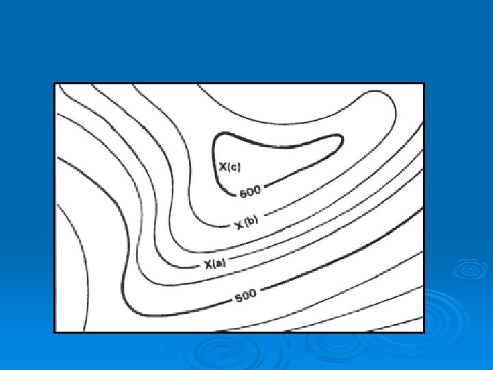
How to read Contour Lines Closer lines=steeper slope Farther apart lines=gentle slope Contour lines coincide=cliff Closed circles or ovals at end of rising contours=tops of hills Long, oval contour lines=ridge Rivers Ø Ø Ø l Lines point in direction of high land from which river flows Depression contours Ø l Indicated by lines pointing inwards from contour
x y y z
Topographic Activity
Water Movement Ø Over time, the constant runoff (moving water) carves a channel into the land. Ø The channel can erode by deep cutting into a V shaped valley. Ex. Grand Canyon OR…. .
Water Movement Ø Ø The channel can erode by side-to-side motion creating bends and turns to form U-shapes.
Ø Erosion – fast water carries away the land. Ø Deposition – slow water deposits (drops) material to build land.
Meanders of a river Meander is a loop or bend in a river. A blocked off meander can produce an oxbow lake.
Water Movement If the channel receives a constant water supply it can be come a stream. Eventually the stream could be come a river or feed into a river!
Water Movement Ø Stream Load: Ø All the material that is carried in moving water. l Suspension =carried by the water l Bed Load • material and sediments that roll along the bed of the stream A stream’s ability to carry material is call the carrying capacity. This depends on the velocity (speed) of the stream. Ø Faster speeds carry more stuff. Ø Ø What happens when the water slows or stops? ? ? !!!!!
Ø Deposition l l Water looses speed as it a reaches the mouth of the river and drops its sediments. This can create an alluvial fan or a delta. Alluvial fans: sediments are dropped when rivers flow down from a large mountain range. Delta: sediments are dropped when rivers enter a larger body of water from a flatter elevation. Mississippi Delta
Water Movement Concept Map (15 minutes) Ø You will have two subgroups (bubbles). Each subgroup must contain the assigned terms. Stream Formation Water Carrying Capacity Side-by-Side Stream Load Deep Cutting Suspension V shaped canyon Bed Load U shaped stream Velocity Ø Add landforms: alluvial fan meander, oxbow lake, delta,
Finish it up Ø Add connecting terms! Ø Add at least 2 pictures. Ø Write your names and turn in!
Water Movement Each stream flows into a larger body of water. Ø All of the lakes and streams in the same area that drain into a larger body of water, are part of a stream system called a watershed. Ø Raleigh is part of the Neuse River watershed. Ø
NC River Basin Research YOU will be assigned one of the North Carolina river basins to research. Ø Resources include: your notes, textbook, internet, PACKET! Ø Work will be presented on a poster that is divided into quadrants. Ø This is NOT a take home project! We will work on each quadrant IN CLASS. Ø Quadrant #1 and #2 today, Quadrant #3 and #4 tomorrow, Finishing Touches Monday Ø Read over instructions and Begin
Standing Water on the Surface 1. A lake is a depression in the surface that collects and holds water. Ø Some lakes will eventually dry up. Ø Eutrophication- lakes become rich in nutrients and overgrown with plants. Ø What causes this? l Nutrient runoff from agricultural fields.
Standing Water on the Surface 2. Wetlands- low-lying areas that are covered with water for a large part of the year. Ø Located near the coast or inland near lakes and rivers. l l Habitat for a diverse group of animals and plants. Year round OR as a resting place for warmer migration. Absorb extra water to prevent flooding Filter pollution. Protect young members of species.
Standing Water on the Surface 3. Estuaries are wetlands that form where salt and freshwater meet. The water is called brackish water.
Wetlands Activity Part I Use the readings to discover different types of wetlands. Part II Create the wetlands analogy chart using items on the tray.
Groundwater Ø The majority of Earth’s freshwater is stored in groundwater. Much of the precipitation that falls on land enters the ground through infiltration and becomes groundwater. Ø How? Ø
Porosity (remember) Ø Ø Ø Four things effect porosity: 1. Vegetation 2. Rate of Precipitationl Light precipitation infiltrates (seeps) into the ground when the ground is not saturated 3. Soil Compositionl Decayed organic matter (humus) or round, coarse particles like sand allow more water l Fine particles like clay, clump together and allow less water. 4. Slopel inclined areas move water faster
Porosity Ø Well sorted sediments increase porosity. Ø Which picture would have the highest porosity?
Groundwater Ø The ability of a material to let water pass through is called permeability. Ø Clay is impermeable due to the particle shape and size, it is often used to line the bottom of ponds and landfills.
Groundwater Zone of Saturationthe depth below Earth’s surface where groundwater completely fills all pore spaces and the material is fully saturated. Ø The upper boundary of this layer is called the water table. Ø Zone of Saturation
Groundwater Aquifer- permeable layers of rock that water can flow through.
Groundwater Systems Ø Springs areas where the water table rises up to the surface. Ø Geysers are explosive hot springs that erupt at regular intervals. Hot springs are usually found in places with recent igneous activity.
Well, Well Ø Wellsl l holes drilled deep into the ground to reach a reservoir of groundwater. To produce water, a well must tap into an aquifer and must be deep enough to not be effected by seasonal fluctuations. What if there is a drought?
Groundwater Activity / Ø Groundwater Well Log Activity l l l Cross-section of the ground at your given well data point. Questions #1 -5 in complete sentences. Paste in your crosssection (folded)
Groundwater Activity / Ø Groundwater Well Log Activity l l Cross-section of the ground at your given well data point. Questions #1 -5 in complete sentences. Paste in your crosssection (folded) 10 minutes
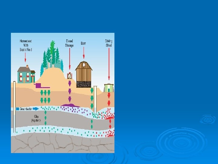
Water Pollution Ø Point vs. Non. Point Water Pollution l Ø Groundwater pollution: l l Ø Examples LUST (Leaking underground storage tank) Chemicals used in the soil. Septic Tanks Sediment Groundwater Conservation l Groundwater is often used at a rate faster than it can be replaced!
Ocean Currents and Barrier Islands part I (10 minutes) A. Read in the textbook: Pg. 395 -398 AND 403 -404 B. Answer the following questions using complete sentences: 1. How does salinity affect the 2. 3. 4. 5. density of water? How does temperature affect the density of water? T/F: As ocean depth increases, temperature increases. What factors cause ocean currents? What major current(s) affect N. C. ?
Ocean Currents and Barrier Islands part 2 (15 minutes) A. Read article. B. Answer the questions. Complete sentences are NOT necessary for this section 1. 2. 3. 4. 5. 6. 7. What are barrier islands? T/F: The Outer Banks of North Carolina are barrier islands. How did the barrier islands form? What are the two primary functions of the barrier islands? What role do waves and currents play in the life of a barrier island? Give two examples of how humans have tried to fight erosion on the barrier islands. Would you build a home on the barrier islands of N. C. ? Use specific evidence from the article to support your answer.
What are barrier islands? 2. T/F: The Outer Banks of North Carolina are barrier islands. 3. How did the barrier islands form? 4. What are the two primary functions of the barrier islands? 5. What role do waves and currents play in the life of a barrier island? 6. Give two examples of how humans have tried to fight erosion on the barrier islands. 7. Would you build a home on the barrier islands of N. C. ? Use specific evidence from the article to support your answer. 1.