Water can exist in 3 phases depending upon


 Two air columns, each with identical mass, have the same surface air pressure.")


 will become more stable (stabilize) as")


 will become more unstable (that is,")


.")
 In a warm cloud composed only of small cloud droplets")
 In a cloud composed of different size droplets, larger droplets")


 process. (1) The greater number of water vapor molecules around the")


 that remain suspended in the")


- Slides: 41
Water can exist in 3 phases, depending upon pressure and temperature. http: //www. sci. uidaho. edu/scripter/geog 100/l ect/05 -atmos-water-wx/ch 5 -part-2 -waterphases. htm http: //chemwiki. ucdavis. edu/Physical_Che mistry/Physical_Properties_of_Matter/Phas e_Transitions/Phase_Diagrams_1
Latent Heat of Vaporization = 600 calories / 1 g Latent Heat of Condensation = 600 calories / 1 g Latent Heat of Fusion= 80 calories / 1 g How much energy to sublimate? http: //www 2. chemistry. msu. edu/courses/cem 152/snl_cem 152_SS 12/pracprob/practiceexam 1. html
http: //www. weather. gov/satellite? image=ir#vis
http: //www. weather. gov/satellite? image=ir#wv
http: //www. weather. gov/satellite? image=ir
Water Vapor
Visible light
Chapter 5 Cloud Development and Precipitation Stability • Stable – parcel wants to sink • Unstable – parcel wants to rise Adiabatic Processes: if parcel of air expands and cools or compresses and warms, without an exchange with the surrounding air. Lapse Rate • Dry Adiabatic Lapse Rate = 10 deg C / km • Wet Adiabatic Lapse Rate* = 6 deg C / km • Environmental Lapse Rate = 4 deg C / km * varies with water vapor content
When rock A is disturbed, it will return to its original position; rock B, however, will accelerate away from its original position.
The dry adiabatic rate. As long as the air parcel remains unsaturated, it expands and cools by 10°C per 1000 m; the sinking parcel compresses and warms by 10°C per 1000 m.
Determining Stability • Warm air rises or is unstable • Cool air sinks or is stable • Compare air parcel lapse rate to environmental lapse rate
(a) Two air columns, each with identical mass, have the same surface air pressure. (b) Because it takes a shorter column of cold air to exert the same surface pressure as a taller column of warm air, as column 1 cools, it must shrink, and as column 2 warms, it must rise. (c) Because at the same level in the atmosphere there is more air above the H in the warm column than above the L in the cold column, warm air aloft is associated with high pressure and cold air aloft with low pressure. The pressure differences aloft create a force that causes the air to move from a region of higher pressure toward a region of lower pressure. The removal of air from column 2 causes its surface pressure to drop, whereas the addition of air into column 1 causes its surface pressure to rise. (The difference in height between the two columns is greatly exaggerated. )
Environmental lapse rate: the rate of temperature change in the surrounding air, if we climbed up in elevation. Determining Stability • Stable environment – Stable = Environmental lapse rate less than moist lapse rate – If an air parcel is forced it will spread horizontally and form stratus clouds – Usually a cool surface (radiation, advection) – Inversion: warm over cool
A stable atmosphere. An absolutely stable atmosphere exists when a rising air parcel is colder and heavier (i. e. , more dense) than the air surrounding it. If given the chance (i. e. , released), the air parcel in both situations would return to its original position, the surface. (In both situations, the helicopter shows that the air is being lifted. In the real world, this type of parcel lifting, of course, would be impossible. )
The initial environmental lapse rate in diagram (a) will become more stable (stabilize) as the air aloft warms and the surface air cools, as illustrated in diagram (b).
Determining Stability • An Unstable Atmosphere – Environmental lapse rate greater than the dry adiabatic lapse rate – As air parcel rises it forms a vertical cloud – Convection, thunderstorms, severe weather
An unstable atmosphere. An absolutely unstable atmosphere exists when a rising air parcel is warmer and lighter (i. e. , less dense) than the air surrounding it. If given the chance (i. e. , released), the lifted parcel in both (a) and (b) would continue to move away (accelerate) from its original position.
The initial environmental lapse rate in diagram (a) will become more unstable (that is, destabilize) as the air aloft cools and the surface air warms, as illustrated in diagram (b).
Conditionally unstable atmosphere. The atmosphere is conditionally unstable when unsaturated, stable air is lifted to a level where it becomes saturated and warmer than the air surrounding it. If the atmosphere remains unstable, vertical developing cumulus clouds can build to great heights. • Moist adiabatic lapse rate is less than the environmental lapse rate which is less than the dry adiabatic lapse rate • Stable below cloud unstable above cloud base • Atmosphere usually in this state
The primary ways clouds form: surface heating and convection forced lifting along topographic barriers convergence of surface air forced lifting along weather fronts
Cumulus clouds form as hot, invisible air bubbles detach themselves from the surface, then rise and cool to the condensation level. Below and within the cumulus clouds, the air is rising. Around the cloud, the air is sinking.
Cumulus clouds building on a warm summer afternoon. Each cloud represents a region where thermals are rising from the surface. The clear areas between the clouds are regions where the air is sinking.
Cumulus clouds developing into thunderstorms in a conditionally unstable atmosphere over the Great Plains. Notice that, in the distance, the cumulonimbus with the anvil top has reached the stable part of the atmosphere.
Cloud Development and Stability • Topography – Orographic ulift – Orographic clouds – Windward, leeward, rain shadow – Lenticular clouds • Topic: Stability & Windy Afternoons – Warm, clear days, windiest part of the day in the afternoon
Orographic uplift, cloud development, and the formation of a rain shadow.
Lenticular clouds that form in the wave directly over the mountain are called mountain wave clouds, whereas those that form downwind of the mountain are called lee wave clouds. On the underside of the lee wave’s crest a turbulent rotor may form.
Relative sizes of raindrops, cloud droplets, and condensation nuclei in millimeters (mm).
Collision and coalescence. (a) In a warm cloud composed only of small cloud droplets of uniform size, the droplets are less likely to collide as they all fall very slowly at about the same speed. Those droplets that do collide, frequently do not coalesce because of the strong surface tension that holds together each tiny droplet.
Collision and coalescence. (b) In a cloud composed of different size droplets, larger droplets fall faster than smaller droplets. Although some tiny droplets are swept aside, some collect on the larger droplet’s forward edge, while others (captured in the wake of the larger droplet) coalesce on the droplet’s backside.
A cloud droplet rising then falling through a warm cumulus cloud can grow by collision and coalescence and emerge from the cloud as a large raindrop.
In a saturated environment, the water droplet and the ice crystal are in equilibrium, as the number of water molecules leaving the surface of each droplet and ice crystal equals the number returning. The greater number of water vapor molecules above the liquid produces a greater vapor pressure above the droplet. This situation means that, at saturation, the pressure exerted by the water molecules is greater over the water droplet than above the ice crystal.
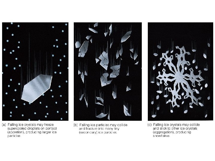
The ice-crystal (Bergeron) process. (1) The greater number of water vapor molecules around the liquid droplet causes water molecules to diffuse from the liquid droplet toward the ice crystal. (2) The ice crystal absorbs the water vapor and grows larger, while (3) the water droplet grows smaller.
Precipitation Types • Rain: falling drop of liquid water – Drizzle less than 0. 5 mm – Virga – Cloudburst • Snow: frozen water falling from sky (crystal or flake) – Most precipitation starts as snow – Freezing level, snow and cloud appearance, fall streaks, drifting snow, blizzard – A blanket of snow is a good insulator • Sleet: Air below freezing, then travels through a layer of air above freezing, begins to melt and then falls through a layer of air below freezing just above the ground surface • Freezing Rain: Ground surface is freezing; as rain hits the surface it freezes
Sleet forms when a partially melted snowflake or a cold raindrop freezes into a pellet of ice before reaching the ground.
Hailstones begin as embryos (usually ice particles called graupel) that remain suspended in the cloud by violent updrafts. When the updrafts are tilted, the ice particles are swept horizontally through the cloud, producing the optimal trajectory for hailstone growth. Along their path, the ice particles collide with supercooled liquid droplets, which freeze on contact. The ice particles eventually grow large enough and heavy enough to fall toward the ground as hailstones.
The tipping bucket rain gauge. Each time the bucket fills with one-hundredth of an inch of rain, it tips, sending an electric signal to the remote recorder.
A microwave pulse is sent out from the radar transmitter. The pulse strikes raindrops and a fraction of its energy is reflected back to the radar unit, where it is detected and displayed, as shown in Fig. 5. 43.
Gaylord, MI Radar Baseline Reflectivity