Water and Early Civilization in Mesopotamia Jason Ur


")
 Red = Vegetation (agriculture) Uruk Southern Mesopotamia")


 e e ev")


 Capitals of the Neo-Assyrian Empire ca. 900 -600 BC")


")

")


 View on Ground (2012)")


 View on Ground (2012)")


- Slides: 44
Water and Early Civilization in Mesopotamia Jason Ur John L. Loeb Associate Professor of the Social Sciences Department of Anthropology Harvard University Water in Context: Exploring water in the Middle East region through GIS mapping and cross-disciplinary perspectives – 28 September 2012
Foci • “Greater Mesopotamia” • Water at a Regional Scale
Modern Mesopotamia
Mesopotamia: Geography
Rainfall in the Middle East
Seasonality of Temperature & Rainfall (Mosul, Northern Mesopotamia)
Assyria Northern Mesopotamia April 2003 (MODIS Image) Red = Vegetation (agriculture) Uruk Southern Mesopotamia
Northern Mesopotamia: Zagros Foothills
Northern Mesopotamia: Rain-Fed Agriculture
Mesopotamia 3 Nov 2003
ct i l Re ( Topography of Southern Mesopotamia L s) e e ev
Marshes of southern Mesopotamia
Water and Mesopotamian Origins ca. 3000 -1500 BC
Head of the Gulf? Uruk
Irrigation in Southern Mesopotamia
Why irrigate? • Quantity of water • Timing of water • Higher and more reliable yields
Water Transport
Mesopotamian Cities City of Ur, ca. 1700 BC
Salinization through Over-Irrigation
Mesopotamia as a Riverine Civilization Settlement and Watercourses ca. 2000 BC
Water and Kings Hammurabi and Shamash, the Sun God
The Dynamic Environment
Small Fluctuations: Oxbows
Levee Formation
Dramatic Shifts: River Avulsions
Abandonment of the Central Floodplain
Northern Mesopotamia Assyria Water in Northern Mesopotamia Uruk
Upper Tigris River Valley
Sennacherib (704 -681 BC) Capitals of the Neo-Assyrian Empire ca. 900 -600 BC
The Assyrian Empire, 900 -700 BC MEDIA SOUTHERN MESOPOTAMIA From Wilkinson et al. 2005, based on Roaf 1990
Assyrian Forced Migration of Conquered Peoples From Layard, Monuments of Nineveh vol. I
Nimrud (ancient Kalkhu)
Negub Tunnel Water for Nimrud? Local Conforming Irrigation to Topograph y
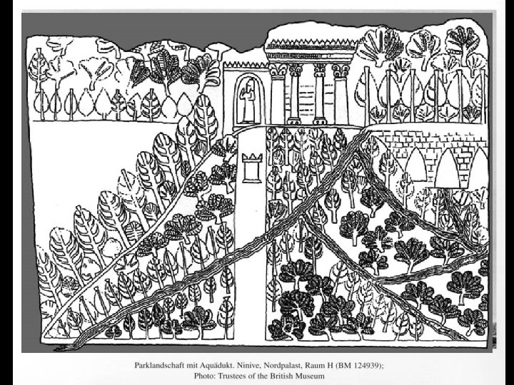
Nineveh (ca. 700 BC)
The Cross-Watershed Earthwork near Bandwai
Sennacherib’s “Northern System” Maltai Canal Faida Canal Bandwai Canal W ad i. M ila h Uskof Canal Kh os r. R ive r Khorsabad Cross. Watershed Earthwork Kisiri Canal Dam at al-Shallalat Nineveh Cross. Watershed Earthwork
Canalhead at Khinis Aqueduct at Jerwan Dam at al-Shallalat Nineveh
Ancient Canals near Bahrka Satellite Image (1967) View on Ground (2012)
The Collapse of Assyria
Qanat/Karez Irrigation
Ancient Karez Satellite Image (1967) View on Ground (2012)
Concluding Points • Water was always a critical element for early civilizations • …but with human ingenuity • Various levels of social organization
FOR MORE INFORMATION, PLEASE CONTACT: DR. JASON UR jasonur@fas. harvard. edu http: //www. fas. harvard. edu/~anthro/ur/