Warning Britain The National Severe Weather Warning Service

Warning Britain: The National Severe Weather Warning Service in action during three recent strong wind events A Fox, F Ralston & R Sherwin © Crown copyright Met Office
 • Developed")
Public Warnings 1987 -2011 • The National Severe Weather Warning Service (NSWWS) • Developed following the Great Storm of October 1987 • Warnings based on probability of pre-defined criteria being exceeded, e. g. 15 mm of rain in three hours • Took little account of impacts
 and Alerts")
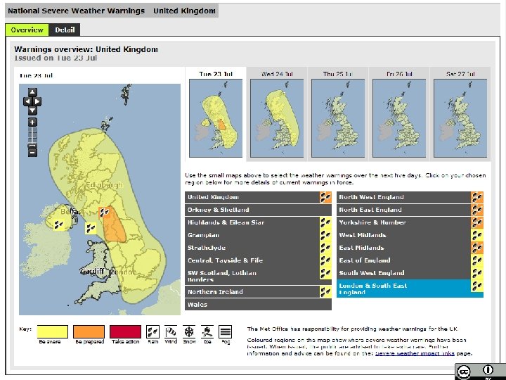
The current NSWWS • Overhauled in 2011 • Warnings (<24 hours ahead) and Alerts (>24 hours ahead), each Yellow, Amber or Red • Rain, Wind, Snow, Ice and Fog • Variable warning thresholds, dependent on location and previous weather • More focussed on impacts of severe weather • Consultation with partner agencies to determine likely impacts

Validity Warning Chief Forecaster’s assessment Weather Impact Matrix

Communicating uncertainty 15/16 December 2011

The probability of winds at a height of 1 km exceeding 60 kt at 0000 UTC on 16 December 2011, from the 0000 UTC run of the ECMWF EPS on 11 December. Valid 15/1800 – 16/2359 © Crown copyright Met Office Valid 15/1800 – 16/2359

Graphics issued 14 December 2011, showing ‘most likely’ and ‘low risk alternative’ tracks © Crown copyright Met Office

Updated graphic, 15 December 2011 © Crown copyright Met Office

A well-warned storm 8 December 2011

Yellow alert issued 06 Dec

First RED warning of the current NSWWS • Consistently forecast strong wind event • Yellow alert first issued on 05 December • Red warning issued on 07 December – high confidence of a high-impact event © Crown copyright Met Office

12 Z and 18 Z analyses, 08 December 2011 12 Z 18 Z © Crown copyright Met Office

What happened • Winds speeds generally in accordance with the warning • Gust 143 kt at Cairngorm (1237 m amsl) • Gust 91 kt at Tulloch Bridge • Estimated 150, 000 homes without power • According to Traffic Scotland, around 20% less traffic on the roads than usual • Hundreds of schools closed in advance • Overall, reduced risk to life © Crown copyright Met Office

An entirely different animal 3 January 2012 © Crown copyright Met Office

A relatively short-notice RED 02 Jan, 12: 13 03 Jan, 08: 14 31 Dec, 11: 29 01 Jan, 10: 51 © Crown copyright Met Office

MOGREPS probabilities for 03/0900 Z DT 03/0600 Z 02/1800 Z Gusts >80 >70 kt

The evolution 18 Z, 02 Jan 00 Z, 03 Jan 06 Z, 03 Jan 12 Z, 03 Jan © Crown copyright Met Office 18 Z, 03 Jan

The event and impacts • Gusts 80 kt at Glasgow Airport, 89 kt at Edinburgh Blackford Hill (134 m amsl) – both major population centres • All major motorway/trunk road bridges closed • Strathclyde Fire and Rescue: 488 incidents by 1300 on 03 Jan, Fife &Lothian 270 incidents • No rail services out of central Scotland – 856 fallen trees to remove from the lines! • ~140, 000 homes without power © Crown copyright Met Office

Thank you – any questions? © Crown copyright Met Office
- Slides: 20