Warmup in Crates FLIPPED CONTINENTS Here are the


")


- Slides: 48
Warmup in Crates! FLIPPED CONTINENTS!
Here are the answers! Make sure yours is correct! Glue in Warmup Notebook! #4 FIND YOUR STUDY GUIDE!
NINE WEEKS Study Guide on your Desk!
nd 2 NINE WEEKS REVIEW
Prime Meridian Imaginary line that cuts the world into eastern and western hemispheres. Imaginary lines that measure the distance a place is east or west of the Prime Meridian are called: LINES OF LONGITUDE
What isisthis of map projection What thistype projection most usedcalled? for? ROBINSON Data representation, most common in textbooks
What type of features that humans have created are typically shown on a map? Look at this map of the US. Political Boundaries
What type of map? I’m a POLITICAL MAP! Shows features humans have created. I’m a PHYSICAL MAP! Shows physical features.
NORTH POLE Brrrrrr EQUATOR SOUTH POLE Brrrrrrr Hot, Hot!
90 high latitudes 0 90 mostly cold temperatures
What factor most strongly influences a region’s climate? Latitude!
What causes the cultural characteristics of a region to change over time? • humans change and move • human innovation • cultural diffusion
DEFORESTATION Ways humans influence their environment! ACID RAIN WATER POLLUTION
Cultural Regions LATIN AMERICA RELIGION MIDDLE MAJOR EAST PRODUCTS ETHNIC GROUPS
Physical Regions CLIMATE VEGETATION LANDFORMS
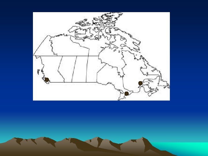
QUEBEC, CANADA • • • FRENCH SPEAKING FIGHTING FOR INDEPENDENCE MAJORITY OF FRENCH-SPEAKING CANADIANS LIVE HERE
3. 4. 4 2. 1. 2 1 1. CARIBBEAN REGION 2. NILE DELTA 3. SIBERIAN REGION 4. GREAT PLAINS 3
What kind of homes were common during Medieval times? CASTLES
PACIFIC ISLAND GETAWAY FALE WITH A THATCHED ROOF
MOST UNIFIED Canada United States India Yugoslavia
Christ Redeemer St. Patrick’s Cathedra Rio de Janeiro, Brazil New York, NY Christianity links people in North & South America
The coniferous forest found in the Subarctic Climate Region. A T A IG
A region where temperatures are always cool or cold and only certain specialized plants can grow Which climate region? TUNDRA
Caste System A social structure which divides people on the basis on inherited social status. Hindus of India
KAABA MECCA, SAUDI ARABIA ISLAM (MUSLIMS)
How would you describe the climate of the Caribbean? O R T ! L A C PI
Communism linked the former Soviet Union and the Eastern European nations between WWII and 1980
Land is very valuable! Name the country that has reclaimed land form the sea by building polders: NETHERLANDS!
Market value of all goods and services produced within a country during a given period of time Gross Domestic Product or GDP
OCEAN CURRENTS
TRUE /FALSE 1. They cause all coastal regions to have cool temperatures. 2. They cause all coastal regions to have warm temperatures 3. They have very little effect on the climate of a region. 4. They cause all coastal regions to have heavy rainfall. 5. They redistribute heat from one area of the ocean
What type of government is shared by both the United States & Canada? DEMOCRATIC!
Match the latitude zone to the climate region: Tropical Subarctic Humid Continental Marine West Coast High Low Mid
What weather phenomena is shown above? HURRICANE
List the 5 major world religions: Christianity 1. Islam 2. Buddhism 3. Judaism 4. Hinduism 5. Circle the religion practiced by the majority of India’s population
Name the Canadian city that is one of the largest cities in the western hemisphere and a center of culture and trade in TORONTO Canada:
Circle the Tertiary Economic Activity: Canning Fishing Ranching Banking
Which of the world’s maj river system is shown on the map? Nile River
Ring of Fire 1. Draw in red the Ring of Fire on the map above. 2. Label the Pacific Ocean. 3. List at least 5 countries that are along the Ring of Fire:
This symbol identifies which feature of a map? Orientation Contour Distance Projection
The former Soviet Union’s Worst nuclear disaster took place at CHERNOBYL _______.
Which continent would you find these structures? EUROPE
Why must nations trade NO NATION HAS ALL THE NECESSARY RESOURCES! THINK ABOUT RESOURCES!
What is the advantage of building a city a confluence site? TRANSPORTATION
Which resource allows a nation to develop a high GDP per capita? State-owned farms Humanitarian aid Skilled workforce Governmental restrictions