Volcanic Hazards Case Studies Volcanic Hazards Case Studies


")


 Long-term (secondary) Over 1700 people killed up")
 • Thousands of cattle, birds and animals")

 Long-term (secondary) • Scientists took gas and water")


- Slides: 31
Volcanic Hazards Case Studies
Volcanic Hazards Case Studies Volcanic event/location Nevado del Ruiz 1985 Mount Ontake 2014 Lake Nyos 1986 Eyjafjallajökull (E 15) 2010 Mount St Helens 1980 Nyiragongo 2002 Nature of the eruption Significant impacts Management
Nevada del Ruiz
Nevada del Ruiz Location: Columbia- In Andean range Type: Stratovolcano Usually generates Plinian eruptions, which produce swift-moving currents of hot gas and rock called pyroclastic flows.
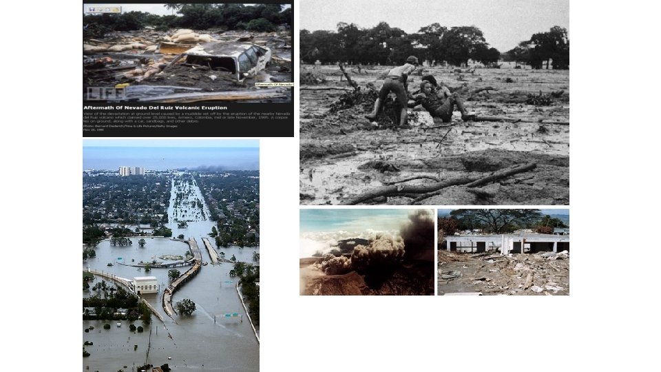
On November 13, 1985, a small eruption produced an enormous lahar that buried and desolated the town of Armero in Tolima Department, causing an estimated 23, 000 deaths. This event later became known as the Armero tragedy— the deadliest lahar in recorded history. (Similar but less deadly incidents occurred in 1595 and 1845, consisting of a small explosive eruption followed by a large lahar )
After nearly a year of minor earthquakes and steam explosions from Nevado del Ruiz, the volcano exploded violently on November 13, 1985. The initial blast began at 3: 06 p. m. , and two hours later pumice fragments and ash were showering down on Armero. However, the citizens of Amero remained calm. They were placated by reassuring messages from the mayor over radio, and from a local priest over the church public address system. Nevertheless, the Red Cross ordered an evacuation of the town at 7: 00 p. m. However, shortly after the evacuation order the ash stopped falling and the evacuation was called off. At 9: 08 p. m, just as calm was being restored, molten rock began to erupt from the summit crater for the first time (all previous eruptions were steam explosions). The violent ejection of this molten rock generated hot pyroclastic flows and airfall tephra that began to melt the summit ice cap. Unfortunately, a storm obscured the summit area so that most citizens were unaware of the pyroclastic eruption. Meltwater quickly mixed with the erupting pyroclastic fragments to generate a series of hot lahars. One lahar flowed down the River Cauca, submerging the village Chinchina and killing 1, 927 people. Other lahars followed the paths of the 1595 and 1845 mudflows. Traveling at 50 kilometers per hour, the largest of these burst through an upstream dam on the River Lagunillas and reached Armero two hours after the eruption began. Most of the town was swept away or buried in only a few short minutes, killing three quarters of the townspeople. Q-
The November 13, 1985 lahar from Nevado del Ruiz - The lahar deposit forms the flat plane at the base of the River Lagunillas canyon. The lethal lahar killed over 23, 000 people, most of which were from the town of Armero, located about 70 kilometers from the summit of the volcano. Courtesy of R. J. Janda, USGS
The November 13, 1985 lahar from Nevado del Ruiz, Colombia After travelling over 70 kilometers from the summit of the Nevado del Ruiz volcano, this destructive lahar buried the village of Armero at the mouth of the River Lagunillas canyon, which was located in the center of this photograph. The lahar killed over 23, 000 people, most of which were from Armero. Courtesy of J. Marso, USGS.
Events Leading up to the Eruption of Nevado del Ruiz • The first sign of volcanic activity started in November, 1984. Small earthquakes occurred and fumaroles, which spew gas and steam, were detected at the summit along with small magma eruptions. • This activity continued for ten months and on September 11, 1985, there was a large ejection of ash from the peak of Nevado del Ruiz. This was a signal that an eruption was imminent. • On November 10, 1985, tremors became more constant. This was a sign of magma movement within the mountain.
Eruptive history & experience The Colombian volcano Nevado del Ruiz is an active stratovolcano with a history of generating deadly volcanic mudflows (lahars) from relatively small-volume eruptions. In 1595, a lahar swept down the valleys of the River Guali and the River Lagunillas, killing 636 people. In 1845, an immense lahar flooded the upper valley of the River Lagunillas, killing over 1000 people. It continued for 70 kilometers downstream before spreading across a plain in the lower valley floor. The young village of Armero was built directly on top of the 1845 mudflow deposit. Over the ensuing years, Armero grew into a vibrant town with over 27, 000 residents. On November 13, 1985, history repeated itself for the third time in 400 years, with another eruption and another deadly lahar racing down the River Lagunillas. This time, over 23, 000 people were killed, including most of the residents of Armero.
A few days before the disaster, a Colombian geology student, José Luis Restrepo, had come to Armero on a field trip. After playing billiards, he was returning to his hotel at about 10: 50 p. m. , when the lahar arrived. His recollection of events were recorded by Dr. Barry Voight: "We didn't hear any kind of alarm, even when the ash was falling and we were in the hotel. . . we turned on the radio. . . The mayor was talking and he said not to worry, that it was a rain of ash, that they had not reported anything from the Nevado, and to stay calm in our houses. There was a local radio station and we were listening to it, when suddenly it went off the air. . . about fifteen seconds later, the electric power went out and that's when we started hearing the noise in the air, like something toppling, falling, and we didn't hear anything else, no alarm. . . The priest from Armero had supposedly spoken on a loudspeaker [around 6: 00 p. m. ] and had said the same thing: that there was no need to leave Armero. . . When we went out, the cars were swaying and running people down. . . there was total darkness, the only light was provided by cars. . . we were running and were about to reach the corner when a river of water came down the streets. . . we turned around screaming, towards the hotel, because the waters were already dragging beds along, overturning cars, sweeping people away. . . we went back to the hotel, a three-story building with a terrace, built of cement and very sturdy. . . Suddenly, I heard bangs, and looking towards the rear of the hotel I saw something like foam, coming down out of the darkness. . . It was a wall of mud approaching the hotel, and sure enough, it crashed against the rear of the hotel and started crushing walls. . And then the ceiling slab fractured and. . . the entire building was destroyed and broken into pieces. Since the building was made of cement, I thought that it would resist, but the boulder-filled mud was coming in such an overwhelming way, like a wall of tractors, razing the city, razing everything. . Then the university bus, that was in a parking lot next to the hotel, was higher than us on a wave of mud and on fire, and it exploded, so I covered my face, thinking this is where I die a horrible death. . . There was a little girl who I thought was decapitated, but. . . her head was buried in the mud. . . A lady told me, 'look, that girl moved a leg'. Then I moved toward her and my legs sank into the mud, which was hot but not burning, and I started to get the little girl out, but when I saw her hair was caught, that seemed to me the most unfair thing in the whole world. " -- from A. Scarth (1999)
The startling figures of loss and destruction were not inevitable. They were due to several factors: • including a lack of systematic volcano monitoring • absence of public policies for disaster prevention and preparedness • Insufficient co-ordination among the various organisations responsible for hazard assessment and emergency planning.
Find out more • Nevado del Ruiz film
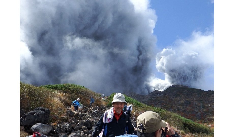
‘The volcano was not under any alerts or warnings at the time of the eruption’ Mount Ontake What went wrong? At 3, 067 meters tall, the is the second tallest volcano in the country second only to Mount Fuji.
Context The science of predicting which volcanoes will produce what type of eruption is in their geochemistry. Volcanoes with silica rich lavas trap gas, erupting violently. Volcanoes with silica poor lavas allow the gas to escape, erupting gently. While details and exceptions can get complicated, the general rule of thumb is that volcanoes over oceanic tectonic plates are gentle, and volcanoes along oceanic-continental boundaries are violent.
36 bodies recovered At least 24 bodies lost on summit 40 suffered significant injuries The eruption started at 11: 53 am Saturday local time. . The volcano is a popular destination for religious pilgrimages, and many hikers were out enjoying the beautiful start to the weekend and the autumn hiking season when the eruption hit Over 50 people were killed when the volcano in central Japan erupted without warning on 27 September (2014), the country’s deadliest volcano eruption since World War II. Several hundred people were thought to have been on the mountain when it erupted at 11. 52 am. More than half of the 56 bodies recovered from the peak of Mount Ontake after the September eruption were found clutching mobile phones with photos of the deadly lava and ash on them “People may say we failed to predict this, but this is something that could not be helped, in a sense. That’s the reality of the limit of our knowledge, ”
Pyroclastic flows on Mount Ontake
Lake Nyos (1986)
Location Lake Nyos is located in western Cameroon, close to the border with Nigeria. Lake Nyos occurs within the Oku Volcanic Field, at the northern boundary of the Cameroon Volcanic Line. Zone of crustal weakness and volcanism (hot spot) Occupies a maar crater which formed from a hydrovolcanic eruption 400 years ago. 30 similar lakes in the region. High concentrations of dissolved CO 2 gas in lower waters
Maars-hydrovolcanic vents • Shallow, flat floored crater • Circular depression • Formed above diatremes due to a violent expansion of magmatic gas or steam (phreatic eruption). High proportion of fragmented basement rocks in ejected tephra. • Filled with water to form natural lakes • Low rims composed of a mixture of loose volcanic rocks and rock torn from the diatreme’s walls. • Excavated into substrate exposing older rock along inner walls • Occur in geologically young volcanic regions
High concentrations of dissolved CO 2 gas in lower waters Volcanic source below lake releases CO 2 and other gases Instead of escaping into atmosphere, most of the gas dissolves into bottom waters of lake http: //www. youtube. com/watch? v=ppbc l MP 76 s&feature=related At a depth exceeding 200 m, weight of upper lake exerts significant pressure on lower waters. A confining pressure is created allowing C 02 to dissolve into bottom waters without escaping to surface Estimation: In lower waters of lake, each litre of water contained 1 5 litres of CO 2.
21 st August 1986 Time: Villagers concentrated in village as cooking/ asleep in huts. If in daytime, children at school/ men herding cattle/ women gathering firewood. Lake Nyos had long been quiet before it happened. Farmers and migratory herders in the West African country of Cameroon knew the lake as large, still and blue. But on the evening(9. 30 pm) of Aug. 21, 1986, farmers living near the lake heard rumbling. At the same time, a frothy spray shot hundreds of feet out of the lake as a jet travelling 100 km/hr, and a white cloud collected over the water. From the ground, the cloud grew to 328 feet (100 meters) tall and flowed across the land. When farmers near the lake left their houses to investigate the noise, they lost consciousness. The heavy cloud sunk into a valley, which channelled it into settlements. People in the affected areas collapsed in their tracks at home, on roads or in the field losing consciousness or dying in a few breaths. In Nyos and Kam, the first villages hit by the cloud, everyone but four inhabitants on high ground died. The valley split, and the cloud followed, killing people up to 15. 5 miles (25 kilometers) away from the lake. Over the next two days, people from surrounding areas entered the valley to find the bodies of humans and cows lying on the ground. Cloud quickly enveloped houses, 120 m above shoreline of lake, within crater (hollow). By Aug. 23, the cloud had mostly blown away, and the silence had lifted. After being unconscious for up to 36 hours, some people revived to find, horrifically, that their family members, neighbors and livestock were dead. The lake had changed, too. It was now shallower; plants and leaves floated in it; and its formerly picturesque blue had darkened into rust. Scientists soon learned that the cloud contained carbon dioxide (CO 2). That finding explained the cloud's heaviness, since CO 2 is denser than air. The cloud was actually CO 2 mixed with air. The CO 2 killed directly by shutting off people's consciousness and breathing. When the CO 2 concentration was 15 percent or less, people lost consciousness and later revived. Individuals who inhaled more than 15 percent CO 2 stopped breathing in minutes and died. As for why the lake ejected CO 2 up to a third of a cubic mile of it scientists disagreed. One camp believed a volcanic eruption released CO 2 and blew up the lake. Another camp thought CO 2 was gradually leaking into and being stored in the lake. When the lake exploded, it released the gas in a gigantic, deadly burp. "While the two camps of scientists were fighting, they agreed that CO 2 killed the people, and the people would be safer on higher ground, " says William Evans, a geochemist with the U. S. Geological Survey who investigated the disaster. The Cameroonian government acted accordingly.
CO 2 monitors were installed on the lakeshore. The monitors were hooked to sirens that would sound if too much CO 2 entered the air. People knew the alarms meant they should go to high ground. As years passed, scientists resolved the debate about the origin of the CO 2. After measuring gas at the bottom of Lake Nyos, they found a CO 2 -rich layer, where levels of the gas were rising over time, suggesting gradual leakage into the bottom of the lake. Scientists looked for markers of a volcanic eruption, such as sulphur and chloride in the lake. They also installed seismometers around the body of water to record tiny earthquakes that would follow a volcanic eruption. "It was the quietest area that the British Geological Survey had ever monitored, " says Evans. The volcano hypothesis died. CO 2 was bubbling into the lake from below via ‘gas springs’ Scientists reasoned that CO 2 had been trapped in the bottom of Lake Nyos for a long time, held down by 682 feet (208 meters) of water. On the day of the eruption, however, something external triggered the release of gas. Some think it was a rockslide from one of the lake's walls. When the falling rocks sunk to the bottom of the lake, they pushed up some gas. Then most of the gas bubbled up. Use colours to highlight: causes, impact, response & management
Socio-economic impacts of the event Immediate (primary) Long-term (secondary) Over 1700 people killed up to 26 km from lake. Majority of victims fell asleep and died from asphyxiation (suffocation) in their beds. Sudden death to villagers of Nyos, Kam, cha and Suburn (as remained concentrated for 23 km). Very few survivors. Those who did survive, fell unconscious, collapsed, were unable to walk or talk and remained weak. Over 300 of the few survivors were hospitalized. Survivors were scarred with ulcers and burns (pressure sores) Raised profile of CO 2 gas as a volcanic hazard Better management of this hazard research in to how to effectively relieve build up Long term evacuation/abandonment of Nyos Price of cattle more than doubled
Environmental impacts of the event Immediate (primary) • Thousands of cattle, birds and animals killed due to CO 2 asphyxiation. • Normal deep blue water converted to murky reddish brown water formed by the oxidation of iron rich bottom waters that were upwelled to shallower lake levels. • Everything within 25 km killed. • Fish killed in the Lake • Shore vegetation was damaged/killed
Management of the hazard at Lake Nyos? • Pumping of gas-rich bottom waters to the surface of the lakes through pipes. • The energy released during degassing is sufficient to drive the pumping operation without any external power source. • Tested on a small scale. • Continuous degassing began in 2001.
Response to the hazard Immediate (primary) Long-term (secondary) • Scientists took gas and water samples • Medical and geological investigations. from the lake and streams. • Survey of deep lakes in Africa & Indonesia to determine if lake overturn was a potential threat at other locations, i. e. potential for dissolved C 02 to accumulate in depths of other volcanic crater lakes and then for lake overturn to trigger depressurization of water and rapid lake overturn. Conclusion: All safe except Lake Kivu, Rwanda. C 02 is accumulating in the lake, of which 2 million people inhabit its shore. Although not yet saturated, a massive geological event could trigger a gas release. The probability of an sub lake eruption or earthquake, releasing millions of tons of asphyxiating gas, is relatively high considering Lake Kivu is situated in an earthquake zone and surrounded by active volcanoes, including Mount Nyiragongo, which erupted recently in January 2002. However, a solution has not yet been implemented at Lake Kivu, risking a repeat of the Lake Nyos tragedy. High gas contents continue to increase in the bottom waters. Nyos and Monoun could become saturated with gas (gas pressure at bottom would equal hydrostatic pressure) in 10 to 30 years, respectively, if gas input rates remain constant.
Find out more Lake Nyos film
Volcanic Hazards Case Studies Volcanic event/location Nevado del Ruiz 1985 Mount Ontake 2014 Lake Nyos 1986 Eyjafjallajökull (E 15) 2010 Mount St Helens 1980 Nyiragongo 2002 Nature of the eruption Significant impacts Management