VISNIR subgroup discussion GSICS annual meeting Shanghai China

VIS/NIR sub-group discussion GSICS annual meeting, Shanghai, China, March 19 -23, 2018

The GSICS VIS/NIR group will be using NPPVIIRS as the calibration reference • Most of the new 3 rd generation GEOs will have similar band spectral response functions as VIIRS. • There will be four more VIIRS instruments on JPSS-1 through JPSS-4 • JPSS-1 launched late last year (operational Jack? ) • Aqua-MODIS is ageing and will be de-orbited by 2023 • Unlike MODIS, VIIRS has many calibrated datasets and archive centers • The NOAA IDPS VIIRS data has not been recalibrated • The NASA Land. PEATE, is currently processing version 5000 (about the 5 th version) • The NOAA and NASA ocean and other retrieval teams are all optimizing the calibration

Proposed NPP-VIIRS calibration reference dataset • Download the IDPS VIIRS dataset and apply the NASA-VCST correction factors that are referenced to the latest Land. PEATE Version 5000 radiances. • Rather than continuously downloading Land. PEATE VIIRS versions • I heard IDPS is recalibrating the VIIRS dataset for public release

MODIS and VIIRS solar band constants • Both MODIS and VIIRS absolute calibration on orbit is the earth view radiance divided by the solar diffuser radiance, otherwise known as a scaled radiance or reflectance (no solar zenith angle term) • The radiances provided on the MODIS and VIIRS datasets are the reflectances multiplied by the MCST and MODTRAN Thullier 2003 solar spectra, respectively • To go from reflectance to radiance or back to reflectance, simply use the band solar constant MCST=509. 3 IDPS=518. 3

MODIS and VIIRS solar band constants These are the MODIS/VIIRS radiance ratio difference, due to solar constant and SRF differences µm MODIS/ VIIRS ratio MODIS MCST VIIRS IDPS 0. 48 B 3/M 3 664. 70 636. 54 0. 55 B 4/M 4 593. 73 0. 65 B 1/I 1 0. 65 SC RATIO These are the MODIS/VIIRS radiance ratio difference, due to SRF differences using IDPS solar spectra µm MODIS/ VIIRS ratio SC RATIO IDPS +4. 4% 0. 48 B 3/M 3 +3. 2 +3. 6 595. 13 -0. 2% 0. 55 B 4/M 4 +0. 2 -0. 2 509. 34 518. 34 -1. 7% 0. 65 B 1/I 1 -2. 1 -1. 7 B 1/M 5 509. 34 487. 08 +4. 1% 0. 65 B 1/M 5 +4. 2 +4. 8 0. 86 B 2/M 7 315. 73 306. 36 +3. 1% 0. 86 B 2/M 7 +1. 2 +0. 7 1. 24 B 5/M 8 151. 16 145. 44 +3. 9% 1. 24 B 5/M 8 -0. 3 -0. 2 1. 37 B 26/M 9 116. 20 114. 57 +1. 4% 1. 37 B 26/M 9 -1. 0 -0. 8 1. 61 B 6/I 3 76. 58 78. 20 -2. 1% 1. 61 B 6/I 3 -4. 1 -3. 1 1. 61 B 6/M 10 76. 58 78. 08 -1. 9% 1. 61 B 6/M 10 -3. 9 -1. 1

VIIRS 0. 65µm reference channel, M 5 or I 1 • VIIRS I bands have a higher spatial resolution, than M bands. But analyzed at the same resolution as M 5 or collectively, would that matter? • The M 5 band has a very narrow spectral band response function (SRF) and the I 1 band has a SRF very similar to many 3 rd generation GEOs • The calibration difference between M 5 and I 1 bands is about 1. 5% 0. 65µm

VIIRS 0. 86 or 1. 6µm reference channel, M or I • The 0. 86 µm I 2 and M 7 bands have very similar SRFs • The 1. 61µm I 2 and M 10 bands have very similar SRFs. 0. 86 µm 1. 6 µm

Rethinking L 1 B calibrated radiance datasets • Currently, every time the L 1 B imager data is reprocessed, which can be yearly, you have to download the whole dataset (TB’s) all over again • If the user could only download the dataset once and apply calibration modules, could save reprocessing and storage requirements • Must ensure accurate calibrated radiances when applying calibration module • The remote sensing instrument community would release a level 1 b dataset that contains all of the required on orbit instrument measurements. • The calibration module can then be downloaded and applied to update calibration, for example the Terra-MODIS WV detector striping anomaly • The instrument providers would then provide a calibration module and test dataset to ensure proper implementation, similar to GOME-2 and SCIAMACHY • I have presented this at the 2017 CALCON and November CLARREO meeting • Two reservations, the users do not want to apply a post calibration (if only grabbing small amounts of the data • The onboard calibration parameters are too extensive and perhaps the instrument calibration team loss of control of the dataset • When reviewing papers that use dataset, make sure the authors attribute the project name, product name, version number and doi.

CLARREO PATHFINDER GSICS requirements • The CLARREO PATHFINDER instrument will fly on the international space shuttle (ISS) around 2021 • Instrument to be operationally for at least one year • Only the solar instrument will fly. The PATHFINDER mission will not have any requirements for climate monitoring and be strictly available for inter-calibration events • The ISS is in a precessionary orbit is ~63 days with an inclination of ~51° • While the ISS is in the sun-synchronous orbit of Aqua, Terra, it will be dedicated to inter-calibrate in these orbit. • The remainder of the time it can inter-calibrate with GEOs using the PATHFINDER pointing capability • Or to characterize ground targets under differing angular configurations
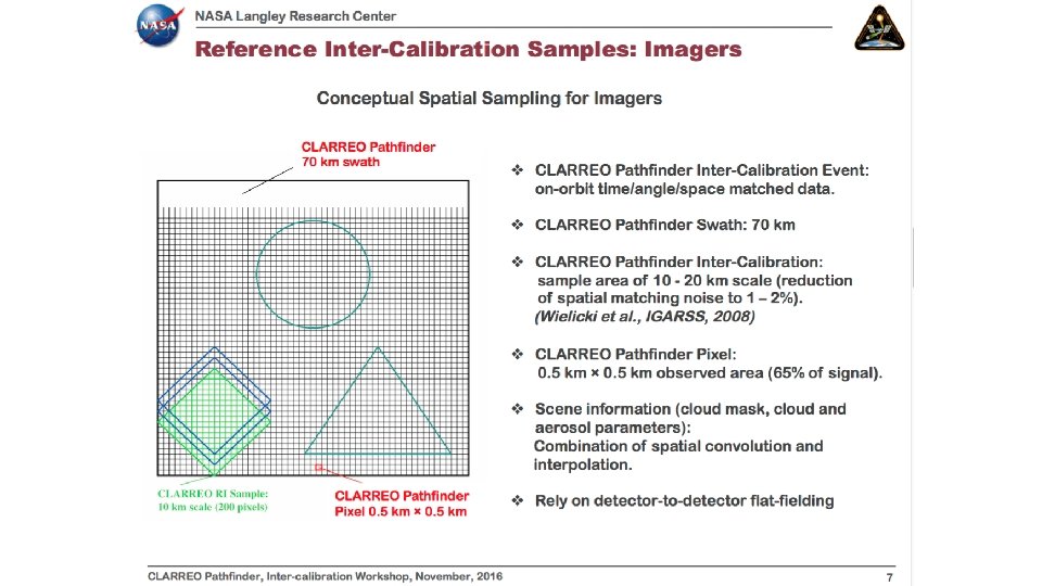

CLARREO PATHFINDER GSICS requirements • Here is the projected sampling activities What sites and GEOs should be sampled and priorities?

GSICS DCC GEO calibration paper • To document the GSICS DCC GEO calibration approach and to provide a reference for the calibration community • Similar to the GSICS IR calibration paper • Would like input from GPRC members • The DCC VIS/NIR methodology will mostly be in common with some variation due to the GEO domain

VIS/NIR 2018 web meeting agenda • Rayleigh scattering approach • Implementation of the DCC method for SWIR bands • GSICS DCC paper web meeting

GPRC VIS/NIR priorities discussion
- Slides: 14