Virtual Reality as an Interface for 3 DGIS


 designers to interactively")

 • more and")


- Slides: 15
Virtual Reality as an Interface for 3 D-GIS Rick Germs, Gert van Maren, Edward Verbree & Erik Jansen Department of Information Technology & Systems Department of Civil Engineering & Geosciences Delft University of Technology ASCI’ 99 Conference, June 15 -17, Heijen, The Netherlands
3 D-GIS & Virtual Reality Project • LWI-funded project • developers: – Delft University of Technology – Cross. Worlds, TNO-FEL, SARA • end-users: – Holland Railconsult – Rijkswaterstaat
3 D-GIS & Virtual Reality Project • Goal: “To enable (infrastructure) designers to interactively visualise, manipulate and analyse (changes in) the landscape and the urban environment with 3 D GIS & VR. ”
Overview • • • Geographic Information Systems Virtual Reality Planning process Views Implementation Future Research
Geographic Information Systems • Spatial data: – geometric (points, lines, polygons) • more and more 3 D GIS and CAD information – thematic (name/address, type, statistics) • more and more data from analysis and simulation • Spatial analysis: – Network analysis (finding routes) – Spatial queries (finding nearest objects)
Virtual Reality Desktop VR Responsive. Workbench CAVE
Planning Process • Infrastructure Design:
Plan View • 2 D symbolic visualisation • Simple GIS functions • VR `map’ tool: – Orientation – Navigation
Model View • 3 D symbolic visualisation • Modelling – arrangement of objects – geographic constraints • Virtual Workbench
World View • 3 D “realistic” visualisation • Presentation – non-experts • immersive VR: – CAVE – Immersa. Desk
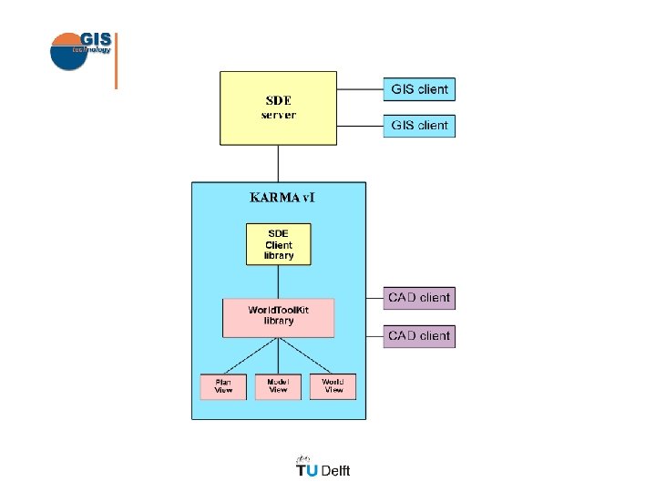
Implementation “Karma” • Components: – VR: World. Tool. Kit – GIS: Spatial Database Engine • Platforms: – PC – SGI, CAVE, Responsive Workbench
Current Status • 2 -way coupling VR and 3 D GIS realized. • Manipulation of GIS objects – rotate, translate, delete • GIS analysis – query, spatial query, identify • End-users will test the system in real-life applications
Future Research • Performance – dynamic loading – level of detail (GIS and 3 D models) • Modelling – geographic constraints – data enrichment • Linking existing datasources – visualising analysis calculations
Delft in the year 1660. . .