Using Total Lightning Data to Improve RealTime Tropical

- Slides: 1

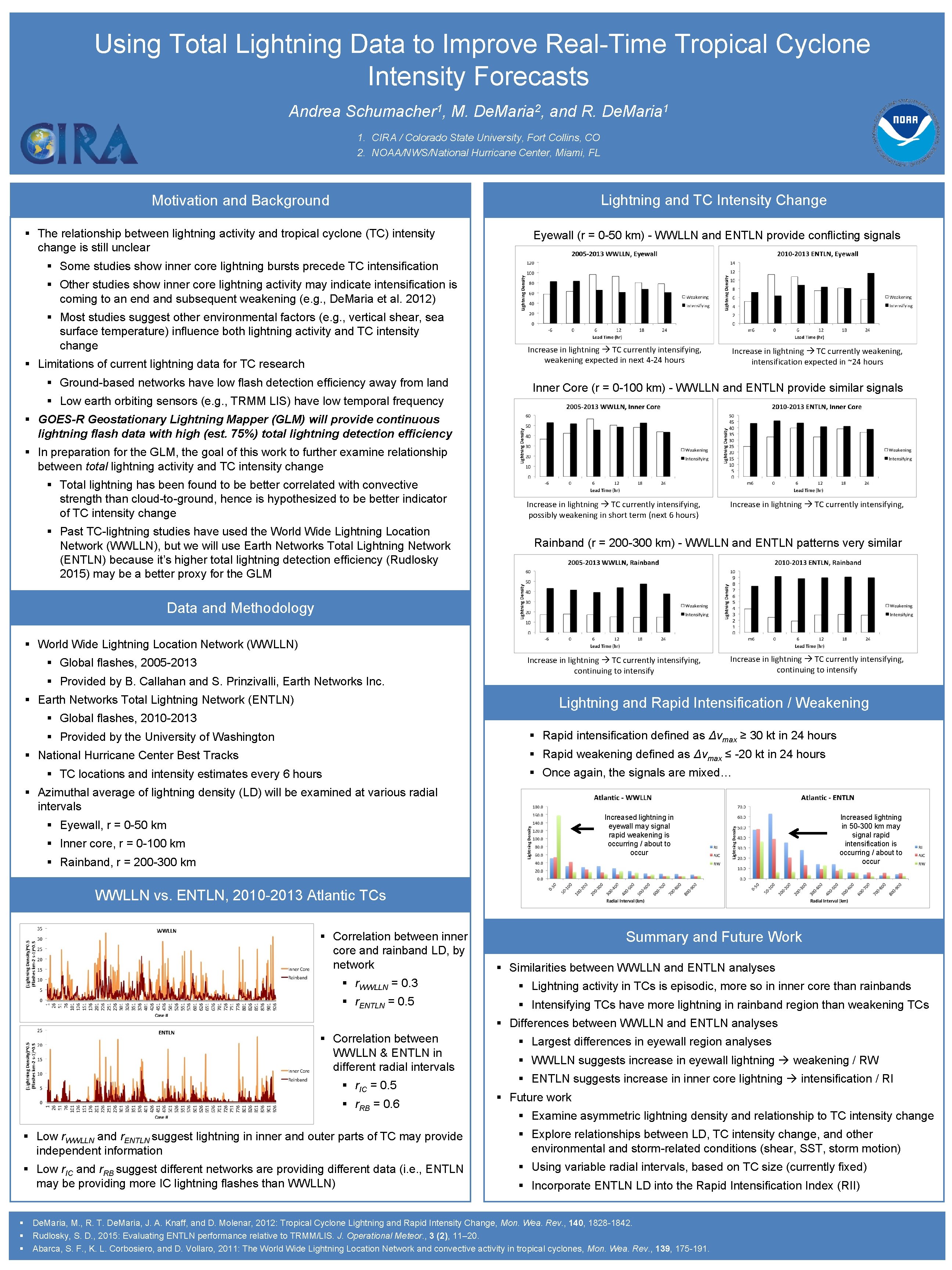
Using Total Lightning Data to Improve Real-Time Tropical Cyclone Intensity Forecasts Andrea Schumacher 1, M. De. Maria 2, and R. De. Maria 1 1. CIRA / Colorado State University, Fort Collins, CO 2. NOAA/NWS/National Hurricane Center, Miami, FL Lightning and TC Intensity Change Motivation and Background § The relationship between lightning activity and tropical cyclone (TC) intensity change is still unclear Eyewall (r = 0 -50 km) - WWLLN and ENTLN provide conflicting signals § Some studies show inner core lightning bursts precede TC intensification § Other studies show inner core lightning activity may indicate intensification is coming to an end and subsequent weakening (e. g. , De. Maria et al. 2012) § Most studies suggest other environmental factors (e. g. , vertical shear, sea surface temperature) influence both lightning activity and TC intensity change § Limitations of current lightning data for TC research § Ground-based networks have low flash detection efficiency away from land Increase in lightning TC currently intensifying, weakening expected in next 4 -24 hours Increase in lightning TC currently weakening, intensification expected in ~24 hours Inner Core (r = 0 -100 km) - WWLLN and ENTLN provide similar signals § Low earth orbiting sensors (e. g. , TRMM LIS) have low temporal frequency § GOES-R Geostationary Lightning Mapper (GLM) will provide continuous lightning flash data with high (est. 75%) total lightning detection efficiency § In preparation for the GLM, the goal of this work to further examine relationship between total lightning activity and TC intensity change § Total lightning has been found to be better correlated with convective strength than cloud-to-ground, hence is hypothesized to be better indicator of TC intensity change § Past TC-lightning studies have used the World Wide Lightning Location Network (WWLLN), but we will use Earth Networks Total Lightning Network (ENTLN) because it’s higher total lightning detection efficiency (Rudlosky 2015) may be a better proxy for the GLM Increase in lightning TC currently intensifying, possibly weakening in short term (next 6 hours) Increase in lightning TC currently intensifying, Rainband (r = 200 -300 km) - WWLLN and ENTLN patterns very similar Data and Methodology § World Wide Lightning Location Network (WWLLN) § Global flashes, 2005 -2013 § Provided by B. Callahan and S. Prinzivalli, Earth Networks Inc. § Earth Networks Total Lightning Network (ENTLN) Increase in lightning TC currently intensifying, continuing to intensify Lightning and Rapid Intensification / Weakening § Global flashes, 2010 -2013 § Rapid intensification defined as Δvmax ≥ 30 kt in 24 hours § Provided by the University of Washington § Rapid weakening defined as Δvmax ≤ -20 kt in 24 hours § National Hurricane Center Best Tracks § Once again, the signals are mixed… § TC locations and intensity estimates every 6 hours § Azimuthal average of lightning density (LD) will be examined at various radial intervals Increased lightning in eyewall may signal rapid weakening is occurring / about to occur § Eyewall, r = 0 -50 km § Inner core, r = 0 -100 km § Rainband, r = 200 -300 km Increased lightning in 50 -300 km may signal rapid intensification is occurring / about to occur WWLLN vs. ENTLN, 2010 -2013 Atlantic TCs § Correlation between inner core and rainband LD, by network Summary and Future Work § Similarities between WWLLN and ENTLN analyses § r. WWLLN = 0. 3 § Lightning activity in TCs is episodic, more so in inner core than rainbands § r. ENTLN = 0. 5 § Intensifying TCs have more lightning in rainband region than weakening TCs § Differences between WWLLN and ENTLN analyses § Correlation between WWLLN & ENTLN in different radial intervals § r. IC = 0. 5 § r. RB = 0. 6 § Largest differences in eyewall region analyses § WWLLN suggests increase in eyewall lightning weakening / RW § ENTLN suggests increase in inner core lightning intensification / RI § Future work § Examine asymmetric lightning density and relationship to TC intensity change § Low r. WWLLN and r. ENTLN suggest lightning in inner and outer parts of TC may provide independent information § Explore relationships between LD, TC intensity change, and other environmental and storm-related conditions (shear, SST, storm motion) § Low r. IC and r. RB suggest different networks are providing different data (i. e. , ENTLN may be providing more IC lightning flashes than WWLLN) § Using variable radial intervals, based on TC size (currently fixed) § § Incorporate ENTLN LD into the Rapid Intensification Index (RII) De. Maria, M. , R. T. De. Maria, J. A. Knaff, and D. Molenar, 2012: Tropical Cyclone Lightning and Rapid Intensity Change, Mon. Wea. Rev. , 140, 1828 -1842. Rudlosky, S. D. , 2015: Evaluating ENTLN performance relative to TRMM/LIS. J. Operational Meteor. , 3 (2), 11– 20. Abarca, S. F. , K. L. Corbosiero, and D. Vollaro, 2011: The World Wide Lightning Location Network and convective activity in tropical cyclones, Mon. Wea. Rev. , 139, 175 -191.