Using AircraftDeployed Low Altitude UAS in Tropical Cyclones


 1. UAS systems checkout and instrument cross comparison")

 1. Fly UAS using P-3 launch, command control 2.")


- Slides: 26
Using Aircraft-Deployed Low Altitude UAS in Tropical Cyclones: Testing in 2009 and plans for 2010 Joseph Cione NOAA/Hurricane Research Division Nancy Ash NOAA/AOC NOAA UAS Workshop February 16, 2010
Demonstration 2009 Coyote launched from free-fall sonobuoy chute
Demonstration 2009 Approved Airspace
Demonstration 2009 Flight Profile
Demonstration 2009 Flight Profile
Coyote UAS Test Flight 090920 I Summary…. Coyote Flight 9/20/2009 Into Warning Area 174 (NW of Key West) Mission Plan: Launch, command & control Coyote using NOAA P-3 aircraft Three Coyote UAS were brought onboard the manned aircraft. The plan was to deploy two UAS with the third to at as a back up. Science team members. Cione, Uhlhorn, Lorsolo (HRD); Ash (AOC); Corcoran, Osbrink (BAE Systems) Mission Synopsis: Takeoff: 930 am local out of Mac. Dill Air Force Base ~1030 am: First Coyote deployed. Parachute malfunction resulted in fast fall. First UAS test release was unsuccessful. Coyote 2: BAE had problems with initialization. Effort aborted. ~1230 pm: Began initializing Coyote #3. Third (and final) Coyote UAS launch was a success. Release time ~1 pm local Operational plan: Fly UAS within a 3 mi x 3 mi ‘box pattern’. Coyote deployed from P-3 @10, 000 ft. Before activating the UAS’ (electric) motor remotely, the Coyote was required to establish 5, 000 ft separation with 43. After several minutes of controlled glide descent, the Coyote was fully operational @5000 ft. Coyote continued descent to 1, 000 ft. The remainder of the flight consisted of repeated ascending and descending controlled soundings between 600 -1000 ft. The last 5 -10 minutes of the flight included control stair-step descent from ~600 ft UAS down to ~64 ft. 4 GPS sondes were released during the 50 -minute UAS test flight. The last drop occurred as the UAS was at ~100 ft altitude. 5000 ft vertical/3 -5 min horizontal separation was maintained. The P-3 conducted ‘multiple spirals’ centered on the Coyote 3 mi x 3 mi boxed flight plan below. (Planned) ‘lost comms’ checks worked as expected. Post-mission observations/lessons learned: BAE’s difficulty in obtaining timely UAS pre-flight initialization. Still, it was the 1 st time BAE operated/worked with P-3/AOC personnel. Improvement is expected next time. Weaker than expected P-3/UAS in-flight communications. After speaking with BAE engineers, they are confident gain can be greatly improved with a stronger antenna/receiver system. BAE says they already have a fix for this and expect no issues going forward. Short battery life. The 50 minute duration will be dramatically increased once a shorter pre-flight routine is established. Reducing/eliminating ‘up soundings’ would also increase duration. BAE also feels that increased battery power (for enhanced duration) is very
2010 Objectives 1. Improve Communications Range (Iridium/ Nav. Air RF transmitter/ amplifier and improved C 2 antenna) 2. 3. 4. 5. 6. Improve UAS endurance (battery) Integrate met sensors onto Coyote (GPS sensors/mistsonde board) Instrument bench testing Pre-season UAS-manned flight test/cross comparison Test UAS in Tropical Cyclone conditions (P-3/UAS mission)
2010 Proposed Time Line 28 Jan: February: March: 1 May: 15 May: 1 June: 7 June: 1 July: 30 Sept: On going: Team meeting ERAU, BAE cost proposals and mission flight plans due Sensor and communications integration begin Airspace approvals secured Complete ORM and NOAA UAS processes Coyote builds completed Sensor integration completed Endurance improvements (battery) completed Communications integration (Iridium/RF) completed Final payload integration and bench test Instrument/UAS flight test completed UAS/P-3 Hurricane flight demonstration completed Project reporting
Partner responsibilities and FY 10 cost breakdown FY 2010 Estimated demonstration cost: $390 K · ERAU (est. $180 K) o o o Payload Integration Support Endurance Improvements RF Enhancements System Integration & Bench Testing Site Survey/Ground Station Integration · BAE (est. $120 K) o o o Engineering project oversight and primary technical consultant for 2010 Labor and final systems integration and build for Coyote UAV (x 2) Preliminary Flight Tests (mission labor & travel for BAE personnel) Flight Demo in Tropical Cyclone (mission labor & travel for BAE personnel) Kickoff meeting with ERAU & NOAA (already complete) Additionally, ~$90 K in ‘hard costs’ required from NOAA in 2010 for: o o Coyote UAV individual hardware components purchases (x 2) Preliminary flight test and Tropical Cyclone demo (travel; Cione and Ash)
Airspace Options (Pre-season 2010 test flight) 1. UAS systems checkout and instrument cross comparison flight -Recover Coyotes Options: Primary: AVON MOA Backups: Kennedy Space Center, Wallops Island
AVON MOA
Airspace Options (in-storm 2010 mission) 1. Fly UAS using P-3 launch, command control 2. UAS instrumented with GPS sensors (PTHU capable) -Do not recover Coyotes Options: Piarco (Barbados or possibly St. Croix deployment) Wallops/Navy controlled airspace (east coast US) Gulf of Mexico warning areas
Barbados and PIARCO
W-168 and W-174
Wallops
Primary Low Altitude UAS Mission Objectives for 2010 – Fill critical data gaps. Provide observations from an important region of the storm that is very difficult (and dangerous) to observe. • Provide high resolution near-surface observations (PTHU) • Ensure real-time data availability – To NHC/EMC (and other interested operational centers) – Fully demonstrate the UAS’ overall capabilities in a variety of conditions within a hurricane environment. Including operations at very low altitudes (<200 ft) – Leverage NOAA’s P-3 manned aircraft to further enhance the utility of UAS-Hurricane missions (e. g. launch, command control from existing NOAA manned assets)
Coyote UAS in-storm Demo open questions…. • 2010: Can the UAS survive (and adequately perform) in a hurricane environment? • This includes (but is not limited to) assessing the UAS’ effectiveness with respect to to in-storm survivability; 2 -way communications and data transmission; flight duration (>1. 5 h); and quality of measurements (PTHU). • Beyond 2010: Additional options, flexibility and improved capabilities? i. In-storm release of multiple UAS? ii. Multiple command control aircraft and/or deployment vehicle options? iii. Significant (4 h+? ) increase in UAS flight duration? (Battery, airframe enhancement? ) iv. Significant increase with respect to UAS-to-command aircraft separation/range? v. More payload possibilities? (Sophisticated and/or higher quality sensors, additional payload space and/or carry capacity? )
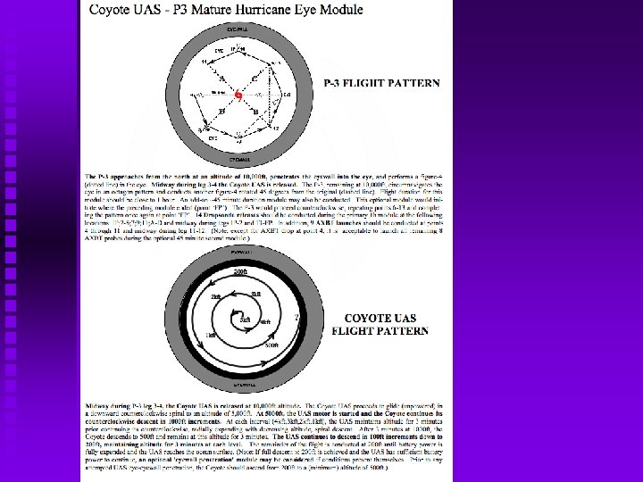
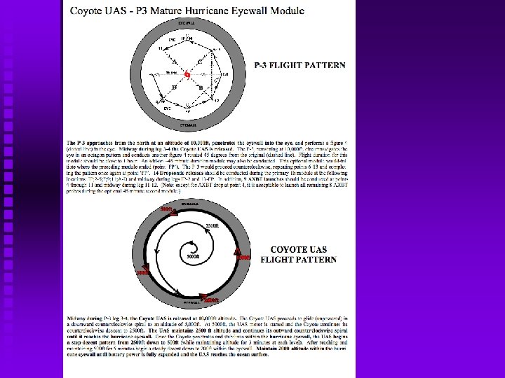
2010 Coyote UAS Mission Possibilities… EYE SOUNDING/LOITERING/EYEWALL EXPERIMENTSResearch objectives: – Improve understanding of TC eye/eyewall heat, moisture and momentum exchange processes; – Continuously monitor TC intensity with the possibility of capturing a rapid intensity change event. (This particular module, for 2010, would be a proof-of-concept only mission since capturing TC intensity change would require multiple back-to-back Coyote UAS launches. ) Mode of UAS transport: As the “launch, command control” P-3 conducts orbits within the eye at altitude (10, 000 ft), the Coyote UAS would initially be deployed in the eye and then circumnavigate (r<50 km) the hurricane eyewall. For the TC monitoring/intensity change module, the UAS would provide PTHU profile and near surface data within the hurricane eye. Potential operational benefits? 1. Unique -continuous- measurements of near-surface winds in the eyewall. Should potetnially help NHC better estimate ‘maximum surface wind speed’. 2. Possible early detection of a rapid intensity change process as ‘loitering’ in the eye takes place.
Discussion: Low Altitude Observing Strategies…. NOAA UAS Workshop February 16, 2010
General Guidelines for Low Altitude UAS Hurricane Missions • Ensure safety • Fill an existing critical low altitude data void in hurricanes • Complement and support NOAA’s existing research & operations • Minimize mission and regulatory ‘risk’ (increase the likelihood for success) • Minimize Cost
LALE TC UAS CONOP comparison Land-launched vs. Air-deployed • Execution of a low altitude UAS TC flight mission…pros and cons First up… Common to both CONOPS Pro: 1. Fill existing critical low altitude data void in tropical systems (significant benefit to both research and operations) 2. Ensure safety (No need for low level manned flight in hurricanes below 5 kft) 3. All UAS operations now fall within NOAA’s existing ORM (risk management) 4. Potential to expand coverage exists now (multiple UAS/storm) Con: 1. Limited payload capability (power/weight/endurance issues) 2. Limited instrumentation options (cost ceiling- given ‘expendable’ nature of platform) 3. Regulatory risk (land-based has higher risk but air-deployed still has some exposure)
LALE TC UAS CONOP comparison Land-launched vs. Air-deployed Execution of a low altitude UAS TC flight mission…pros and cons Land-launched: Pro: • • No ‘Mothership’ required Obtain observations 100’s of miles from TC in addition to inner core Con: • • • To date, restrictive range limitations exist (~500 mi 1 -way). Mission execution determined by TC position relative to a fixed UAS deployment location. Significant ingress and egress mission failure risk. (Flight into and out of the storm comprise >70% of UAS mission time. ) Significant regulatory risk. (FAA is especially leery of ‘fair weather’ ingress/egress portions of the proposed flight) Operations require very early deployment of the launch team, often days before an inherently uncertain event. (increased mission failure risk) Very high cost in dollars and in time. Consistent successful execution of this conop requires several pre-position deployment sites and teams. Large travel and labor costs including multiple site surveys and months of planning to coordinate. A myriad of logistical issues need to be addressed (including but not limited to: lodging, ITAR import/export regulation, securing required national and international airspace clearances, operator clearances, local media requests, etc). Operations potentially involve a complex chain of (required) real-time communication (e. g. ground-based UAS operators, mission scientists, manned
LALE TC UAS CONOP comparison Land-launched vs. Air-deployed Execution of a low altitude UAS TC flight mission…pros and cons Air-deployed: Pro: • • • If manned aircraft is within operational range of a TC, so is the UAS. No ingress/egress mission or regulatory risk. No need to establish on-the-ground mission assets or team pre-deployments (reduced mission risk, cost) Aircraft command control results in streamlined communications (reduced overall mission risk) Leverage of existing NOAA hurricane field operations infrastructure including manned assets (Ao. C, HRD) and aircraft instrumentation (P-3 launch, command control, P-3 communications, data, and expendable deployment systems) Potential for significant overall cost and personnel savings (pre-season: minimal logistics set-up time and cost; in-season operations: reduced travel and labor costs) Con: • • If manned aircraft is out of operational range, so is the UAS. (Mothership dependent) To date, limited endurance/range capability (restricted storm coverage/UAS)