Use of Paleoseismic Data in Seismic Hazard Analysis


")
")


 • remote")


")
")
- Slides: 22
Use of Paleoseismic Data in Seismic Hazard Analysis: Examples from Europe K. Atakan and A. Ojeda Institute of Solid Earth Physics University of Bergen Allégt. 41, N-5007 Bergen, Norway Tel: +47 -55 -583413 Fax: +47 -55 -589669 E-post: atakan@ifjf. uib. no
Seismic Hazard and Risk Geology & Geophysics Earthquake Seismology Active fault data Historical seismicity Instrumenta l Seismicity Geodetic/ geophysical data Earthquak e sources Sitespecific Seismic Hazard Probabilistic Seismic Hazard Assessment Local Site Effects Earthquake Engineering Regional Seismic Hazard Seismic Wave Attenuation Site-specific Spectral Hazard Seismic Risk Index Vulnerability of the site Earthquak e Recurrenc e. Models Ambraseys Model 1 Boore et al. Site parameters Model 2 Campbell Building parameters Model 3 Sadigh et al. Geotechnical Engineering Civil Engineering Seismic Risk Class
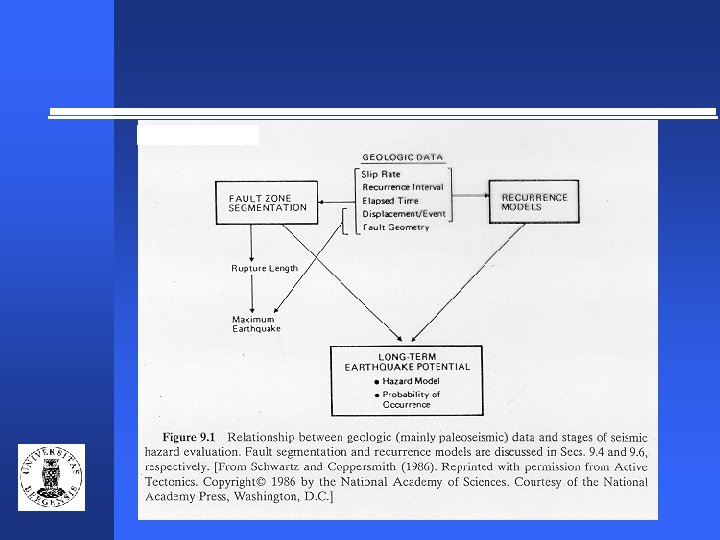
(Mc. Calpin and Nelson, 1996)
(Mc. Calpin, 1996)
Seismic Hazard Assessment Probabilistic Deterministic Scenario Based models Site specific analysis Hybrid Models Poissonian Models Renewal Models
Seismic Hazard in the Catalan Coastal Ranges
Seismic Hazard in the Catalan Coastal Ranges Probabilisitic seismic hazard maps for various return periods. Earthquake occurrence is based on a Poissonian model.
Seismic Hazard in the Catalan Coastal Ranges
Seismic Hazard in the Catalan Coastal Ranges
Seismic Hazard in the Catalan Coastal Ranges Maps showing the difference between the renewal and the poissonian models at various return periods in terms of PGA (in cm/sec 2). The influence of the paleoseismic data become more visible at larger return periods.
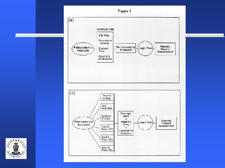
Uncertainties In General: uncertainties may be divided in two categories: • Uncertainties due to the lack of sufficient data these can be improved with additional data • Uncertainties due to the lack of understanding of the phenomena additional data may not necessarily improve the understanding In Paleoseismology: uncertainties may be grouped into two: • Analytical and/or numerical uncertainties • Uncertainties related to the interpretation of data and/or observations
Preferred sequence of paleoseismic investigations • Regional Scale (thousands of km 2) • remote sensing, aerial photo’s, • geological mapping, geophysical investigations • and other background knowledge • Local Scale (a few km 2) • geomorphic mapping, Quaternary • stratigraphic framework • Site Scale (1 hectare to a few m 2) • geophysics (shallow depth/high resolution) • fault-zone trenching • other detailed observations and • data collection
Paleoseismological interpretation process goes through the following stages: • Stage 1: Regional scale investigations that are dependent on the rate of deformation/tectonic setting and the background knowledge • Stage 2: Local scale investigations and the site selection for detailed analysis • Stage 3: Extrapolation of the observations that are made at a site scale to the entire fault. • Stage 4: Identification of the paleoearthquake(s) based on the diagnostic criteria • Stage 5: Dating techniques used for the age determination of the paleoearthquake(s) • Stage 6: Paleoearthquake size estimate and the recurrence interval
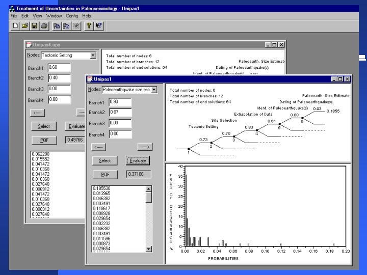
UNIPAS acts as a link between the paleoseismic data and seismic hazard assessment UNIPAS Paleoseismic data Seismic hazard assessment
Paleoseismic Quality Factor The logic-tree analysis used in the paleoseismic interpretation process may be interfaced with the logic-tree analysis in the seismic hazard assessments through Paleoseismic Quality Factor (PQF). PQF is expressed by the following: PQF = Pes x Cri where, Pes is the probability of the preferred end-solution in the logic-tree analysis for the paleoseismic investigation and Cri is a correction term for the relative level of importance of the investigation in seismic hazard analysis.
Level of importance of the paleoseismic investigation in seismic hazard assessment The relative levels of importance may be grouped into five categories: Level 1: Site-specific seismic hazard analysis (SHA) Level 2: Regional probabilistic seismic hazard assessment Level 3: Input as seismotectonic sources in probabilistic SHA Level 4: Identifying the earthquake potential of the fault (zone) Level 5: Determining if the fault (zone) is active (i. e. observable co-seismic slip during the Holocene)
PQF is the connecting link between the logic-tree for paleoseismic data and the logic-tree for seismic hazard assessment PQF Logic-tree for paleoseismic data Logic-tree for seismic hazard assessment
(Mc. Calpin and Nelson, 1996)
(Wells and Coppersmith, 1994)