US National Grid USNG FGDCSTD011 2001 For information
 FGDC-STD-011 -2001 For information, see: www. fgdc. gov/usng Harnessing a")


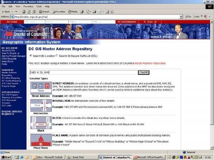
 lookup the USNG value for a street address or")


 Sample of how FEMA GIS depicted the USNG at the zone")


")


 for Geoaddressing. . . NPCRS")


 Terry, 1994, Photogrammetric Engineering & Remote Sensing, Vol 63, No.")


 and")

- Slides: 72
US National Grid (USNG) FGDC-STD-011 -2001 For information, see: www. fgdc. gov/usng Harnessing a national grid as a preferred language of location. . . … optimized for local applications.
Please note, there are many ways to describe a location with coordinates. The US National Grid being discussed here is just one of them.
Non-Standard Grids Problems & Impact w, no l i t. n s u d grid p gri a p a m ed dm s r u a d g tan s e lon v tc! a ’ e e d , e W S s I , G n’t u S e P v a G ith ly h w p s m i k We s that wor one Same street names, but different grids. A Survey of Washington, DC Commercial Street Maps Found 35 different maps… … with 31 different grids. None worked with GPS receivers.
A Standard Grid. . . …a consensus based standard. - A communications enabler. … a nationally consistent language of location. - Geoaddress on maps. Point of Interest - Universal Map Index Street Address Subway Sandwich & Salads 2030 M St. , NW Subway Sandwich & Salads 430 8 th St. , SE Subway Sandwich & Salads 3504 12 th St. , NE Subway Sandwich & Salads 1500 Benning Rd, NE - An enabler… a bridge between hardcopy maps and digital. - Frictionless interoperability USNG Grid: Telephone: (202) 18 S UJ 2256 0826 2698 0567 2740 1120 2815 0757 223 -2587 547 -8200 526 -5999 388 -0421
USNG… framing issues. - USNG is an FGDC process standard -- It is a presentation process standard. - It is not intended to define internal storage structure of any GIS or to the transfer of coordinates between databases or appliances. - Intended for ground operations. For the general public, public safety, and commerce. - For maps generally >1: 1, 000 -scale. - Not applicable to aeronautical and nautical operations as such.
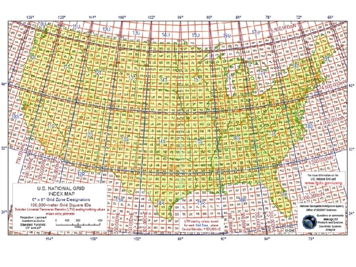
How to read the USNG… U UTM/USNG Grid Zone Designations 48°N 126° 120° 114° 108° 102° 96° 90° 84° 78° 72° 66° T 40°N S 18 S 32°N R 24°N 10 19 11 12 18 13 14 15 16 17 08/27/98 MGRS Grid Zone Designations Jefferson Pier: 18 S UJ 2337 0651 (NAD 83)
U. S. National Grid GZD: 17 T 100, 000 m Square Identification GZD: 17 S 700 600 4400 PD 500 78°W QD GZD: 18 T Jefferson Pier: 18 S UJ 2337 0651 GZD: 18 S 300 400 UJ TJ 4300 PC 400 4200 KB 4300 NC 300 LB QC TH VH UH 4200 MB NB PB QB TG VG UG 4100 KA 4000 300 4400 4100 LA MA 400 NA 500 PA 600 QA 700 VF UF TF 400 300 Grid Zone Designation 18 S Grid Zone Designation 17 S 78°W 4000
The Power of Truncated USNG Values Jefferson Pier, Washington, DC Grid: UJ 23370651 = repeat of UJ 23370651 Each 2 letter/8 digit USNG value (10 -m posting) in the outlined area is unique.
Reading Grid Coordinates… “ Read Right, Then Up. ” The Jefferson Pier is located at grid 2337 0651 18 SUJ 23370651 4 -digit: 23 6 -digit: 233 8 -digit: 2337 10 -digit: 23371 06 06519 (think 2337 / 0651) Principal Digits = 1, 000 m 22 = 100 m = 10 m 07 = 1 m precision 24 23 07 Grid: 2337 0651 Read RIGHT to grid line 23 Then measure right another 370 -meters. Jefferson Pier 06 06 18 S UJ 2337 0652 UTM values. 4305000 m. N Grid: 2306 05 322000 m. E USNG: 18 S UJ 0 23 Scale Datum: NAD 83 24 1, 000 -m Then, read UP to grid line 06, and measure UP another 510 -meters.
2 85000 m. E 4325000 m. N 90 95 TJ UJ 3 00 US National Grid 05 10 15 20 25 30 35 40 25 20 20 15 15 10 10 05 05 UJ TJ TJ 43 00 UJ TH TH 43 00 UH UH 95 95 90 90 85 42 85 90 95 Datum: North American Datum 1983 (NAD 83) Grid Zone Designation: 18 S 3 TH 00 UH 05 Scale: 10 15 20 25 30 Jefferson Pier: 18 S UJ 2337 0651 35 85000 m. N 45 E 3 000 m
Often asked question: Why not use Lat/Long, state plane, 5’ grids, 2. 5’ grids, etc, instead of UTM/USNG, etc…. ? 1. Latitude / Longitude a. Many different position reporting formats. b. Just how far is 1 minute of longitude anyway? c. Ever tried to accurately fix a position to within 10 -m using a paper map and lat/long? 10 out of 12 authors of GPS “How to” books recommend UTM over Lat/Long. , Ease of use, fewer human errors. 2. But we have GPS!!! a. GPS is wonderful at providing a position (PNT). b. As a map… not so good! Small GPS screen: 1, 600 -mm 2 Small, low resolution screen Large 7. 5’ quad: 256, 000 -mm 2 Large synoptic, high res view. c. Applying GPS position to map in the field. – See 1. c. above. Map and GPS same relative size. - But the # 1 REASON IS THAT THE US NATIONAL GRID IS A NATIONAL STANDARD! Why? See Reason 1. c. above!
Example: dcgis. dc. gov/mar_client_sample/ Low-end High-end
“Lack of a uniform method for describing incident locations has long been a major impediment to rapid and effective emergency response in diverse metropolitan and rural areas. . . …the immediate impact of USNG will be to ensure that GPS is directly usable with properly gridded map products to quickly enable multi-agency and multi-jurisdictional emergency responders, and the public in general, to precisely identify geolocations in the real world. …the USNG will be a principal integrating mechanism to create spatial interoperability nationwide. . . among multi-jurisdictional civil emergency response organizations and when necessary, between those organizations and the military to support any and all domestic emergency response and disaster relief operations. ” - Appendix E Spatial Interoperability Defense Science Board Task Force on the Future of the Global Positioning System, October 2005.
One approach: Cartographic anarchy. Many non-standard grids & spatial ref. systems. Many civil sector polygon and reference systems in Hurricane KATRINA 2005 Local areas by geographic features is good, but no standard spatial reference grid.
Multiple non-standard reference systems: = Not compatible with GPS, C 2 systems, etc. = Does not enable trained forces or interoperability. = Operational friction during mutual assistance. Local (state) quadrangle reference system.
Grids are good but. . . a standard grid reference system is essential. The alternative is operational friction.
Location, location. . . What exactly is a 911 Grid Map?
KATRINA Lessons Learned in Mississippi: “ 3. The implementation of a standardized reference system. We recommend the use of the US National Grid (USNG). We made the mistake of initially improvising a search and rescue grid and then modifying that grid for local use. Hundreds of copies of each were published. The USNG is a readily available standard that is yet to be adopted by emergency response agencies due to lack of education. ” From proposed: Joint Emergency Mapping System for Mississippi (JEMS), Center for Interdisciplinary Geospatial Information Technologies Delta State University, Mississippi 19 November, 2005
Common Ground Alliance “Miss Utility” map reference system - Nonstandard notations - Adds operational friction Lat/Long increases: Alpha characters increase:
The value of an alternative approach: Results of Research at an ABCA Conference Hypothesis: Standards, doctrine, and training based on a standard grid will substantially reduce operational friction and improve operational effectiveness. Scenario: Disaster has struck Blues City in Blue Land, requiring formation of a coalition to support civil authorities in disaster response. Part I: Without prior notice or special training coalition officers are provided a 1: 50, 000 topographic map of Blues City, romer scale, and requested to locate features provided by USNG/ MGRS grid coordinates. Part II: Given rapid planning requirements, coalition countries must produce their own maps of Blues City located on a UTM zone junction.
The value of an alternative approach: Results of Research at an ABCA Conference Part I: Without prior notice or special training coalition officers are provided a 1: 50, 000 topographic map of Blues City, romer scale, and requested to locate features provided by USNG/MGRS grid coordinates. Results: Of 64 attempts, 63 points located.
Part II: Given rapid, disbursed planning requirements, coalition countries must produce their own maps of Blues City located on a UTM zone junction. Results: Within an hour street data had been downloaded from Blues City web site and a properly gridded map prepared per normal procedures.
DC GIS users can 1) lookup the USNG value for a street address or 2) zoom to a location with a USNG value. Auto-complete capability. Data is in MD SPCS, USNG functions for public.
USNG geoaddress and universal map index value.
“Turn right at 438 Northing. ” 83 84 44 438 n 43 “Street Sign-in-a-Box” concept
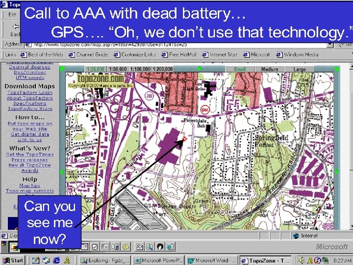
Arlington Co. VA 9 -1 -1 Operator; ‘We can’t use a GPS coordinate. ” Motorcycle accident, Sept 10, 2003, 7: 55 AM. USNG readout for cursor
Four Pillars of Implementation -Maps - Education. Legend with USNG grids. (hard copy & digital) Community Consensus (Public/Business/Government) e n o D ’s rid C G D FG onal ti a N S U - User Friendly GPS/ Internet and Wireless Connectivity - Geoaddress Availability US National Grid
Questions? Comments? Analog---------Bridge----------Digital For information, see: www. fgdc. gov/usng
Backup Slides
St. Louis, MO GIS Web Site Street address look up. . . Functions like a Universal Map Index
ppt
YP BU
Organization of UTM zone 18 84° N 500, 000 -m. E 78° W EQUATOR 75° W 72° W 0 -m. N 10, 000 -m. N 0° 500, 000 -m. E 80° S
UTM Zone Junction - Zones 15 - 16 Zone 15 500, 000 -m. E 7. 5’ quads 96° W 0° UTM grid lines 93° W EQUATOR 84° N 500, 000 -m. E 7. 5’ quads UTM grid lines 90° W 87° W EQUATOR 0° 500, 000 -m. E 84° W 0 -m. N 10, 000 -m. N 500, 000 -m. E 72° WW 78° 80° S
UTM Zone Junction - Zones 15 - 16 Zone 1 5 500, 00 0 -m. E 96° W 0° EQUAT OR 93° W 84° N 6 Zone 1 7. 5’ quads 0 500, 00 UTM grid lines -m. E 87° W 84° W 0 -m. N 0° 500, 00 Point of tangency 0 -m. E 90° W 80° S
USNG Zone Junction New Orleans, LA • GIS technician training requirements emerge from Hurricane KATRINA, 2005. • Additional issue. It has been suggested that MGRS/USNG cannot be used by aircraft supporting ground operations. FGDC US National Grid (WG 84) = Military Grid Reference System (WGS 84) See www. fgdc. gov/usng for additional information
USNG Zone Junction New Orleans, LA • Training requirements emerge from Hurricane KATRINA, 2005. - “We tried to implement the USNG in New Orleans early on but based on the visual confusion of the product (see Doug’s example), it was dropped for a Lat/Long grid. ” - FEMA, GIS Coordinator, DHS/FEMA Region X, email of Friday, May 5, 2006, 11: 00 Next slide depicts how the grid was used.
(“Doug’s FEMA Example”) Sample of how FEMA GIS depicted the USNG at the zone junction in New Orleans, LA during Hurricane KATRINA, 2005. Warning: This is not how the USNG zone junction is cartographically handled and this method does not work with low-cost GPS receivers.
USNG Zone Junction • Proper way to handle the grid at zone junction: – Survey ops: Uses UTM numerical coordinates. Extend one zone across into the other (not both). Carry survey across and then establish control in new zone. – Position referencing: Uses USNG alpha-numeric format. • Do not extend zones across into adjacent zones. Each point has an absolute value based on the zone that point is located in.
15 R YP 90°W 16 R BU Sample of NGA produced map with properly depicted USNG/MGRS grid at the junction of UTM zones 15 / 16.
Examining use of the USNG/MGRS in the field across a range of technologies; - paper to integrated GPS/INS - at the UTM Zone Junction. - air/ground operations. New Orleans, LA, 22 August 2006
Ground location scaled from paper USGS 1: 24, 000 topo: Grid: 106 193 11 or 16 R BU 106 193 11 Note the UTM Zone Junction. This presents no problem for the map user.
Using an NGA issued map with standard grid, the helicopter crew easily identified the precise grid location: 16 R BU 106 193. 10 11 1 2 3 4 5 6 19
The helicopter crew also loaded the coordinates into their integrated GPS/INS navigation system, grid 16 R BU 106 193. The FLIR can be slaved to the GPS/INS to stare at the point.
The crew looks from big to little features on the map and ground as they orient themselves to the point of interest. The FLIR can aid in situational awareness.
The grid zone junction was immaterial to the success of this evolution.
Situations the US National Grid will remedy. . . Miami, FL -- The story of a lady’s drowning quickly gained National coverage after she dialed 9 -1 -1 on her wireless phone from her sinking car in a Miami, FL canal. Not able to escape the car and with dispatchers unable to locate the accident scene, the woman perished before emergency help could reach her. Fort Lauderdale, FL – A lady was forced to wait seven minutes and make three separate 9 -1 -1 calls from her cellular phone before help was dispatched after her daughter was impaled by a three-foot steel rod that had crashed through their windshield. The lady was forced to exit the interstate and find a major intersection in order to give the dispatchers her location. From National Emergency Number Association web site and other sources.
Day County, SD – A lady spent 40 hours in temperatures that dropped to -30° F when a blizzard stranded her in her pickup truck. Although she was able to dial 9 -1 -1, she was unable to tell her rescuers where she was. While the Day County Sheriff’s office was eventually able to locate the car, it took them five hours to place the vehicle within a 35 -mile radius. Rural Michigan – A lady was rear-ended and suffered minor damages while driving in rural Michigan. While no one was injured, she did call 9 -1 -1. She informed the dispatcher of her location and then waited 30 minutes for the cruiser to arrive. When he failed to materialize, she called again. The two roads that she had given to the dispatcher to help them locate her actually crossed twice, and the cruiser was looking at the wrong intersection. From National Emergency Number Association web site and other sources.
Washington, DC – In 2001, a visitor to the FDR Memorial was struck with a heart attack. A passing police officer and the dispatcher could not agree on an appropriate address for the incident location at this large campus like memorial. Eventually an intersection several blocks away was selected, but the ambulance was never able to find the incident. Arlington County, VA. - In 2003, a motorcyclist was seriously injured after being thrown over the guardrails of an overpass. A pedestrian nearby immediately called 9 -1 -1 but had trouble determining an address for the incident. He did have a GPS receiver, and finally asked in frustration if the 9 -1 -1 operator could use a coordinate from it. The operator replied that no, they did not use that technology. From National Emergency Number Association web site and other sources.
Fairfax County, VA – A caller to 9 -1 -1 reported having been stung by a bee, and was beginning to have trouble breathing. The 9 -1 -1 operator could see clearly on the map where the caller was located with Phase II wireless location technology, but had no actionable way of describing the caller’s location in the 493 acre park to first responders. From National Emergency Number Association web site and other sources.
Two perspectives on using coordinates. . . In Rhode Island, cell phones equipped with GPS chip sets can be rapidly located to within 15 -m of true position. 9 -1 -1 organizations remain focused on conventional addresses, yet only about a fifth of the street addresses have been correlated to a coordinate. For incidents where the provided coordinate cannot be correlated to a street address there is no way to readily communicate a location to first responders who can only use street addresses to find places. As the Rhode Island 9 -1 -1 Director Ray La. Belle stated, "If I give an ambulance driver latitude and longitude coordinates, he's going to tell me where to go. " (Lagesse, 2003). “. . . In Iraq, Coalition Forces (particularly the U. S. Govt and U. S. Military) are using MGRS coordinates almost exclusively. They have GIS software and data that allows them to search for a particular address (building #, street # and house #) within the 9 districts of Baghdad and in a few other cities/regions of Iraq. The operators in the field will get intel about a person of interest being located at a particular address. We will use the GIS sw/data to locate that address on a map or imagery of the city. Then, using our data, we can provide an MGRS coordinate for that location. The operator can then plug that coordinate into his GPS and easily navigate to the building of interest in order to do surveillance. ” - US Government person, December 2005
The Modern Devil Dog…. …synergistically using analog and digital tools. “The map was my most important tool. With that, a compass, and a radio, I was God in the wilderness. Preserving the map from the weather, I had learned from bitter experience, was a lifesaving effort, …” - 1 st Lt Michael C. Hodgins, USMC Reluctant Warrior, Vietnam, March 1970 - Billet holders will be getting D-DACT. A GPS receiver in the pocket. - Paper map: Does not A paper map manipulate or communicate data. in hand. - Allows basic geospatial analysis (KOCOA) - Provides a synoptic view. - Batteries never die.
Digital 3 D modeling and simulations, interconnected simulators, but sometimes. . . Briefing and rehearsal Note sand table/terrain model.
Sand Tables Note use of grid lines
Physical Implementations of Geoaddresses
Relevant URLs DC Master Address Repository http: //dcatlas. dcgis. dc. gov/MAR/ 1620 L St NW USNG: 2331 0803 DC GIS http: //dcgis. dc. gov St. Louis, MO Parcel Data by Address http: //stlcin. missouri. org/citydata/newdesign/index. cfm http: //stlcin. missouri. org/citydata/newdesign/addressparser. cfm? addresssearch =&previouspage=data The National Map http: //nmviewogc. cr. usgs. gov/viewer. htm FGDC US National Grid resource site: http: //www. fgdc. gov/usng
Geoaddress A two-dimensional earth referenced address based on the U. S. National Grid (USNG) that supplements conventional onedimensional street addresses. Geoaddresses unambiguously communicate the surface location at which an organization or person can be reached, and act as a universal map index for properly gridded topographic, street, highway, and general purpose maps. Geoaddresses may serve a temporary (i. e. reporting an accident location), or permanent purpose, (i. e. associated with cultural features). Away from the road network, or in the event of major disaster, geoaddresses may be the only readily usable ‘address’. Geoaddresses enable the widespread use of the Global Positioning System (GPS) in society, and enhance the use of web based/digital and hardcopy maps. Example: USGS National Center 18 S TJ 9473 1361
Value of a Standardized Grid Ø User friendly way to describe precise locations for all users. Easier to use than lat/long. Reduced training requirements. Ø Provides a cross check between a street address and geoaddress to ensure information is not garbled in transmission. Ø Increase the speed and accuracy with which places can be identified on a map or in a GIS. No ambiguity. Includes all places--not just roads. Ø Enables creation of a universal map index of places and facilities. Ø Improves navigation to, and within, incident areas by responding external forces/mutual assistance situations. Ø Sets a presentation format standard. USNG does not replace GIS data storage formats or SPCS in survey and engineering operations. Ø Improves coordination between different responding agencies (to include local, state, federal, and general public). Ø Nonproprietary standard facilitates rapid implementation by commercial maps and software applications. Ø Facilitates use of simple, digital, communications systems such as Short Messaging Service (SMS) when cell phone voice circuits are overloaded during crisis. Ø ENABLES THE USE OF GPS! USNG now used in commercial GPS.
From research into, “Why not lat/long instead of plane coordinates. ” Human factors: Types & Percentages of Positional Errors 120. 0% 100. 0% 80. 0% 60. 0% 40. 0% 13% 73% 32% 66% 57% 34% 20. 0% 08/27/98 Pos Errors - Type & % 150+m = blunders 15 m to <150 m <15 m ~ NMAS Green (15 m) equates approximately to (12 m) the National Map Accuracy Standard (NMAS). 12% UTM full grid UTM tic marks Lat/long full graticule Terry, 1994, Photogrammetric Engineering & Remote Sensing, Vol 63, No. 4, Apr 1997, p. 381 - 383.
08/27/98 UTM or SPCS?
The Requirements of a United States National Grid (USNG) for Geoaddressing. . . NPCRS Requirements Public Domain Geodetically Referenced Plane Coordinate System Seamless at Political Boundaries Possess Powerful Truncation Features 08/27/98
USNG = UTM? MGRS/NAD 83 - Why? O ff the Shelf S R G S M Options C g P n S S o L S / t PL UTM La Public Domain Proprietary Geodetically Referenced PLSS Latitud e Longitu / de Plane Coordinate Seamless at Political Boundaries Simple/Powerful Truncation Filtering Requirements 08/27/98 UTM/MGRS/NAD 83 = Why? UTM/MGRS SPCS UTM Now on consumer GPS receivers
Meets National Map Accuracy Standard 08/27/98 Terry, 1994, Photogrammetric Engineering & Remote Sensing, Vol 63, No. 4, Apr 1997, p. 381 - 383. Pos Accuracy Bullseye
08/27/98 User’s Preference (91%) Terry, 1994, Photogrammetric Engineering & Remote Sensing, Vol 63, No. 4, Apr 1997, p. 381 - 383.
Think of it as a “street sign-in-a-box” Threshold Automobile GPS Initiative TAGI
FGDC-STD-011 -2001 United States National Grid www. fgdc. gov/usng “We should promote voluntary standards that enhance the effective coordination of disaster responses, such as the U. S. National Grid map standard for geospatial information system; ” - The Honorable John H. Marburger, III Director, Office of Science and Technology Policy. Testimony of Dec 5, 2001 before the Subcommittee on Science, Technology and Space Committee on Commerce, Science, and Transportation, United States Senate.
“Problems/Issues/Gaps: Responders’ lack ability to share information between the MAC (Multi-Agency Coordination Entities) and area command posts is partially due to weak communications and interoperability standards. This is evidenced by situations where MAC and area commands may both be utilizing digital maps, but with different indexing standards. The result may be an inability to easily exchange map coordinates. ” -A Project Responder Report: Technology Opportunities for Implementing the National Incident Management System (NIMS) Of October 2005, p. 31, by Hicks and Associates, Inc. , for The Memorial Insitute for the Prevention of Terrorism and the United States Department of Homeland Security.
MGRS A Brief MGRS - USNG History 1914 - WW I: Convergence of technologies. Necessity mother of invention. French develop use of grids. Lat/Long too hard for average soldier. WW I Lesson: Grids are great. Everybody develops one. 1940’s WW II: Many different grids in use. Projection issues. Operational friction. WW II Lesson: Get everyone on standard grid. 1945 - 1949: US and British armies develop and implement UTM and Military Grid Reference System (MGRS). Great success story; Used in combat ever since. USNG Mid - 1990’s: No standard civil grid equiv. GPS arrives. 9/11. USNG development at FGDC. MGRS could answer the requirement, no need to be original… but NAD 27 US issue. USNG/WGS 84 = MGRS/WGS 84 USNG/NAD 27 not = MGRS/27