Urbanization Urbanization Definition Growth and diffusion of city

Urbanization

Urbanization � Definition �Growth and diffusion of city landscapes and urban lifestyle � Can be difficult to define what a city is and number of people needed to classify it � Most MDCs are highly urbanized � Number and % of urban dwellers in LDCs has exploded in recent years �Many city governments are trying to manage explosive urbanization � 10 million a year die from overcrowding and inadequate infrastructure
 � MSA a term used by the U. S. Census")
Metropolitan Statistical Areas (MSAs) � MSA a term used by the U. S. Census Bureau to identify a geographic unit of area including central city and all of its immediately interacting counties with commuters and people directly connected to the central city �An MSA is an urbanized region with a minimum of 50, 000 people in it �Often MSA boundaries overlap � Example “The Triangle” N. C. �Urban “blobs” led to coining of term “megalopolis” � Originally used to describing fusing of Washington, D. C. and Boston �Also uses a unit called a micropolitan statistical area � Area of the surrounding counties integrated into a central city with a population of 10, 000 to 50, 000 � Many formerly rural areas

Rate vs. Level of Urbanization � Rate of urbanization �Definition: � Speed at which the population is becoming urban � Level of urbanization �Definition � Is the % of people already considered urban � Level of urbanization in the U. S. is nearly 75% �That means nearly 75% of U. S. population lives in urban places �HOWEVER rate of urbanization much higher in China � Versus its overall lower level

Where Urbanization Began � Geographers analyze where urbanization 1 st developed and why urbanization because in these urban hearths � Geographers analyze the path of urbanization’s diffusion from these hearths and related gaps in urban development among different countries � Several qualities are common among places that were urban hearths �A dependable water supply, a long growing season, domesticated plants and

Where Urbanization Began � Agricultural Urban Hearths �Earliest cities were born around 3500 B. C. E. � Came from agricultural villages � Earliest urban hearths existed in: � Mesopotamia � Indus River � Nile Valley � China � Mexico, Peru � Trade-Based Urban Hearths �Some cities grew as established marketplaces where traders came together to buy and sell goods from across the region � Urbanism spread westward throughout the Mediterranean region and spread eastward through overland caravan routes through Persia into India, China, and then Japan � Specialization began to occur as certain cities

Where Urbanization Began �Greco-Roman Urban Hearths �Greeks and Romans erected cities as centers of political and administrative control over their conquered regions �Cities were planned �Religious Urban Hearths �Some cities grew as centers of religious ceremony that were

Pre-Industrial Cities �Definition: �Those that are developed prior to industrialization and shared several characteristics �Rural settlements surrounding the urban space provided agricultural products to urban dwellers, who in turn provided different economic functions �Cities served as trade centers and gateways to foreign lands and markets �Pre-Industrial Colonial Cities �Definition: �Cities built and developed by colonizers in conquered lands �European imperialism fueled creation �Shared common characteristics �Wide boulevards �Classical architecture �Constructed with the aim of exporting raw materials back to the mother country

Pre-industrial cities � The “urban-banana” �By the beginning of the 1500 s, a majority of cities were located in trade centers that extended from London to Tokyo � Made a crescent shape , “urban banana” � Included: � London, Paris, Constantinople, Venice, Cairo, Nanking, Hanchow, and Osaka �The “urban banana” resulted from both site and situation factors

Pre-Industrial Cities �Internal Economic Structure of Pre. Industrial Cities �Often had a diverse mix of economic functions in any given space �Rather than zoning that came with industrialization �Shops, markets, homes, and government often jumbled together in urban space �Still separated by wealth

Industrialization and City Structure � Urban-Industrial Revolution � In 1800, only 5% of world’s population lived in cities � Diffusion of industrialization is largely responsible for urbanizing the world’s people � Not equal distribution � European Industrial Revolution � related to Imperialism � Triggered diffusion of city growth � Urbanization grew in a snowball process � Growth of factories and urban jobs attracted rural farm workers � Started in England � Created a steady rural-urban migration pattern � England’s urban population was 24% in 1800, 99% by 1999 � The 2 nd Agriculture Revolution � Supported the pattern of industrial and urban growth � More efficient and productive agricultural practices developed � Led to more workers moving to cities for jobs � Improved food supplies also supported an increasing population

Industrialization and City Structure � The Industrial City � By mid-1700 s formerly great land-based cities were fading away � Sea-trade centers were growing rapidly � St. Petersburg, Russia � By the early 1900 s, most of the world’s great cities were American or European industrial cities � Manchester, England; Chicago, Illinois; Barcelona, Spain � Industrial cities had a different function from the pre -industrial city � Rather than serve mainly as administrative, religious, trade, or gateway cities primary function was to make and distribute manufactured products � Shock Cities � The pattern of rapid urban growth and urban migration led to growing urban spaces that were overwhelmed with the influx of urban in-migrants � Definition: � Urban places experiencing infrastructural challenges related to massive and rapid urbanization � Challenges often include: � Slums, hazardous pollution levels, deadly fires, urban prostitution, and exploitation of children � Examples: � Manchester, England � Less than 80, 000 in 1750 � 500, 000 by 1850 � Chicago, Illinois � 30, 000 in 1750 � 500, 000 by 1830 � 1. 5 million by 1900

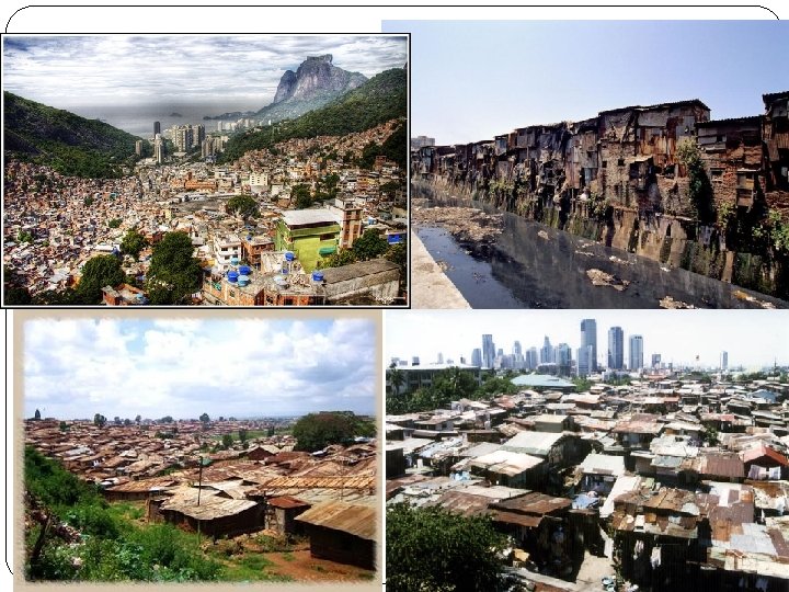
Industrialization and City Structure � Strained Infrastructure �An important trend in modern urbanization is its diffusion to LDCs � Currently highest rates of urbanization are occurring in LDCs �Urbanization in LDCs is often focused on one or two major cities with a high degree of primacy rather than being spread out throughout the country � Such intensely high rates of urbanization in LDCs are straining the infrastructural resources �Large migration streams of young adults moving from � Squatter Settlements �Many migrants are unable to find housing and build squatter settlements �United Nations estimated that 175 million people lived in squatter settlements in 2003 �Definition: � Makeshift, un-safe housing constructed from any scraps they find on the land they neither rent nor own � Called favelas or barriadas in Latin America, bastees in India, kampongs in Malaysia

Urban Systems �Defining urban systems �All urban places are part of an interlocking urban system of cities that operate within a network of spatial interaction �A. k. a- urban places interact with each other and are interdependent �Geographers analyze the spatial distribution of cities and try to determine why cities

Central Place Theory � Walter Christaller’s theory �Developed theory as a means of studying the geographical patterns of urban land use � Specifically looking to explain and predict the pattern of urban places across the map �Assumptions: � Flat land surface � Uniformly distributed rural population � Equal transportation methods � Main ideas �Central places are urban centers that provide services to their surrounding rural people � Also called hinterland �Range, Threshold �Spatial competition implies that central places compete with one another for customers �Illustrates that higherorder central places contain economic functions with high

Central Place Theory �Hexagonal Spatial Pattern �Model predicted hexagonal pattern of urban, central places �Central places vary in their degree of “economic reach” �Higher-order central places have larger ranges and thresholds �lower-order central places have smaller ranges and thresholds

Urban Hierarchy � Central place theory predicts that if a population is evenly distributed, there will be a hierarchy of evenly spread central places to serve the population � Urban hierarchy � Definition: � System of cities consisting of various levels, with a few cities at the top level and increasingly more settlements on each lower level � The position of a city within the hierarchy is determined by the types of central place functions it provides � Higher the position in the hierarchy= the higher the population being served by the central place and the more variety of central place functions performed in the city � Hierarchy � There are few urban central places are the top of the hierarchy � Example: Chicago

Applying Central Place Theory and Urban Hierarchy: An Example � Central place theory provides one piece in the jigsaw of understanding and predicting geographic patterns or urban places � Over past thirty years, populations in the U. S. south and west have increased and become wealthier overall � With more people and wealth, more services were needed �Phoenix, Atlanta, and Dallas moved up on the urban hierarchy as they � As these cities moved up the ladder, other cities took their place and others fell �Tampa, San Antonio, Charlotte moved up �Cities from Northeast and Midwest fell in rankings � Ex. Cleveland, Detroit

Rank-Size Rule/ Primate Cities �There is a relationship between a city’s population size and its place on the urban hierarchy within its urban system �In MDCs usually predicted using ranksize rule �Some urban systems have disproportionately large cities, called primate cities �ex: Bueno Aires, Argentina is nearly 10 x the size of the 2 nd-largest

World Cities � In the interlocking, interacting network of cities throughout the world’s urban system, there exist some world cities �Powerful cities that control a disproportionately high level of the world’s economic, political, and cultural activities � Sometimes called global cities � Distribution �Group of world cities have shifted � 1600 s- London, Amsterdam, Lisbon � 1700 s- Rome, Paris � 1800 s- Berlin, Chicago, New York City, St. Petersburg �Today world cities are centers of global financial decisions, flows of information, and TNCs � NYC, Tokyo, London � Pan-regional Influence �Definition: � A reach that extends beyond the city’s own region into other centers of

Megacities �All megacities are large and have over 10 million inhabitants �Examples: �Beijing, Cairo, Mexico City, Jakarta
- Slides: 22