Urban Patterns Urbanization The process by which people

Urban Patterns

Urbanization • The process by which people live and are employed in a city.

Social Area Analysis • The distribution of different types of people in an urban area. (example of Portland, Oregon) This map also shows gentrification. What is gentrification? ? ?

Cities Throughout History Ancient Cities : Walled, Temples and Palaces in Middle, settlements surrounding. Graves outside the cities, well planned, narrow passages City States: Trade oriented, diffused along the Mediterranean Roman Cities: Connected by roads Medieval Cities: Walled cities in Europe, supported by surplus from rural areas

The three Urban Land Use Models

Burgess’ Land Use Model/Concentric Zone Developed in the 1920 s • As used in urban areas: society within an urban area is often arranged in a series of concentric rings in positions defined by social factors. – The most expensive land is often in the center the city and the land on the edge of the city is cheaper. – Cities grew outwards from the original site so the oldest buildings would be in the middle of the city and the youngest would be on the edge.

Burgess Model A. Central Business District B. Zone in transition C. Zone of independent workers' homes D. Zone of better residences E. Commuter's Zone

Limits to the Burgess model • Model was developed before the advent of mass car ownership. • New working and housing trends have emerged since the model was developed. Many people now choose to live and work outside the city on the urban fringe. • Every city is different. There is no such thing as a typical city

Sector Model • Developed by H. Hoyt. • This model assumes the land use is conditioned by transportation routes radiating outward from a city center. • Industrial, retailing, and residential districts extend out from the CBD like wedges. • Hoyt saw the best housing extending north from Chicago along Lake Michigan

Does Denver follow the Sector Model?

Multiple Nuclei Model • This model assumes that urban areas have more than one focal point influencing land use. • These nuclei most often develop in response to the evolving transportation network. They form, for example, around major highway intersections and surrounding airports. • These multiple nuclei may have arisen in one of two ways: – They were once separate settlements but were absorbed by growth of the urban area.

Multiple - Nuclei Model

Comparing The Latin American City Structure • What are the differences and similarities between the aforementioned models and the Latin American City Structure Model

Gateway Cities • Ports of entry and distribution centers for large geographic areas. • Proximity to ports, natural harbors, and raw materials – – – – – San Francisco New York City Chicago Guangzhou, China Cape Town, South Africa Panama City Rio de Janeiro, Brazil Sydney, Australia Calcutta India

Forward Capital • A capital city placed in a remote or peripheral area for economic, strategic or symbolic reasons. • Examples: – Brazil: Brasilia – Malawi: from Zomba to Lilongwe – Pakistan: from Karachi to Islamabad – Malaysia: from Kuala Lumpur to Putrajaya – Japan: from Kyoto to Tokyo

Urban Sprawl and Edge Cities • Expansive suburban development over large areas in which the automobile is the primary source of transportation. • Edge Cities are located on the outskirts of larger cities.

Megalopolis A entire region in which cities have grown together and has become highly urbanized. Examples: -Eastern Seaboard, U. S -LA-OC-San Diego, Tijuana -Sao Paulo-Rio de Janeiro. Brazil -Tokyo-Osaka Japan

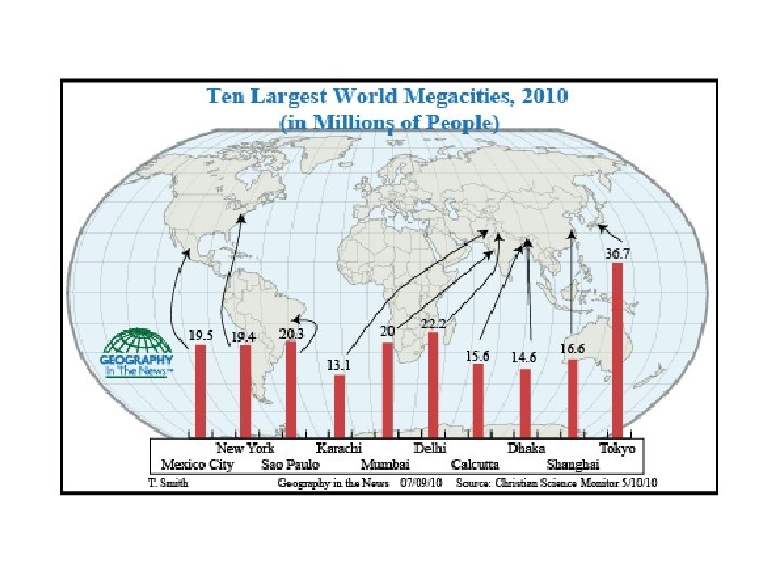
Megacities • Cities with more than 10 million people. • A megacity can be a single metropolitan area or two or more metropolitan areas that converge. • As of 2013, there are 24 megacities in the world • Examples: – – – Tokyo Delhi Mexico City New York Shanghai

Important Vocabulary • • Squatter Settlements Redlining Urban renewal Gentrification

Squatter Settlements

2013 APHG FRQ • #3 Over the past 150 years, railroad and highway systems influenced patterns of urban growth in the United States. – Identify and explain one way that railroads affected the size and one way that railroads affected the form of cities in the United States between 1870 and 1920. – Identify and explain two ways that the Interstate Highway System affected cities in the United States between 1950 and today.

Route 66 Bypassed Radiator Springs

2009 • #2. A large proportion of urban residents in the megacities of the periphery of the world system live in squatter settlements. – A. Describe a typical location of squatter settlements within urban areas of megacities on the global periphery. – B. Describe two factors that contribute to the formation of squatter settlements. – C. Give a detailed account of THREE consequences of the rapid growth of squatter settlements. The three consequences you discuss may be social, economic, political or environmental.
- Slides: 24