Unit III Nutrients Biomes Nutrient Cycles Carbon Cycle

Unit III Nutrients & Biomes

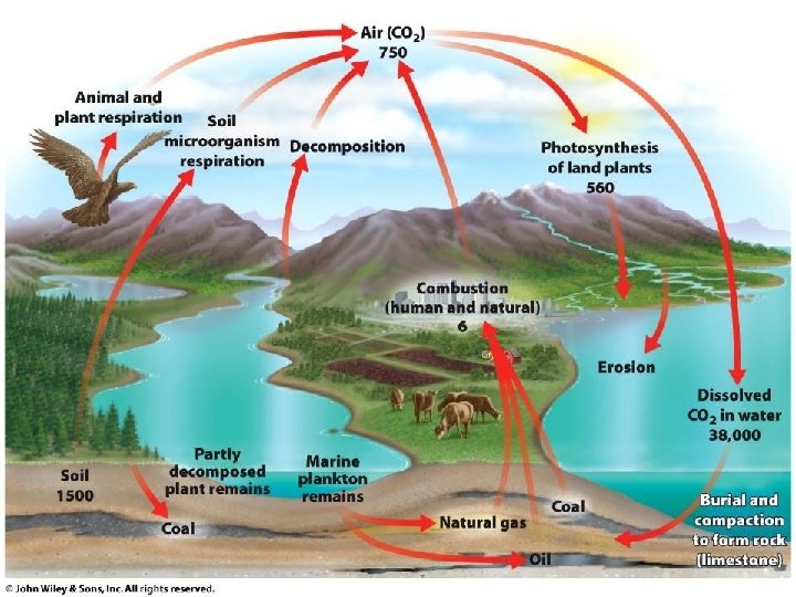
Nutrient Cycles – Carbon Cycle • Based on CO 2 cycling from animals to plants during respiration and photosynthesis. • Heavy deposits are stored in wetland soils, oceans, sedimentary rocks. – under right conditions, can become fossil fuels • Released by combustion and volcanic activity. • Returns to the soil from the atmosphere through rainfall – Carbonic Acid + H 20 = Rain with a p. H of ~5. 4

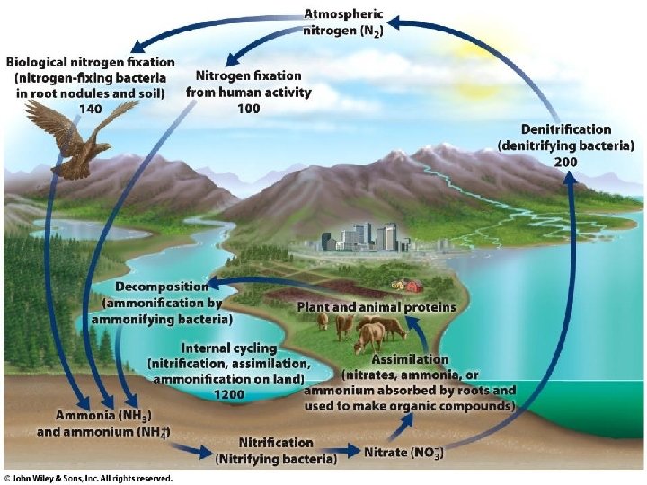
Nutrient Cycles – Nitrogen Cycle • Nitrogen Fixation • Nitrification • Passed on to animals.
 usually")
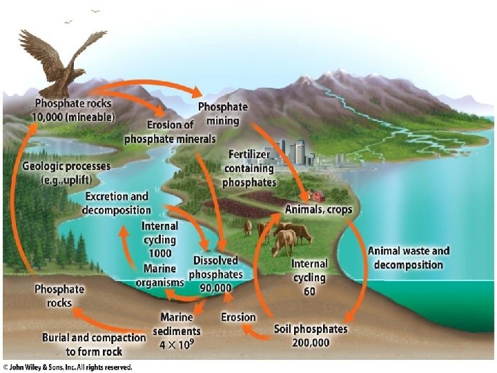
Nutrient Cycles – Phosphorous Cycle • Based on phosphate ions (PO 43 -) usually found in rock formations and ocean sediments. – Released by weathering and volcanic activity.

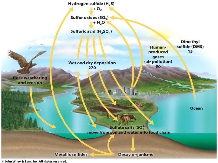
Nutrient Cycles – Sulfur Cycle • Most sulfur found in rocks, minerals, and ocean sediments. • Sulfur enters atmosphere through weathering, sea spray, and volcanic activity (H 2 S, SO 2).
 Water Cycle • Evaporation and Transpiration • Condensation")
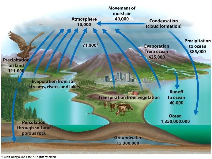
Nutrient Cycles – Hydrologic Cycle (aka) Water Cycle • Evaporation and Transpiration • Condensation and Precipitation • Infiltration and Percolation • Runoff

• Troposphere Atmosphere – inner layer of the atmosphere – physical properties include: • Stratosphere

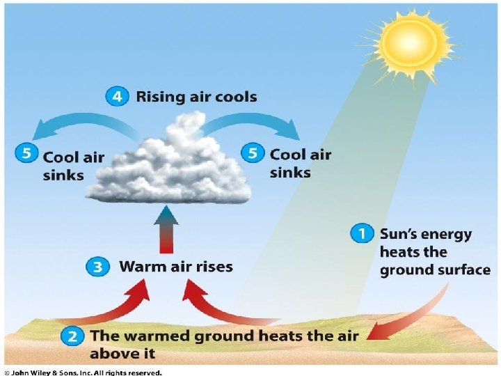
Winds • Global air circulation patterns are affected by:

What is the Earth’s tilt? 23. 5º

Winds • Warm Fronts – leading edge of a mass of warm air converging on a mass of cool air

Winds • Cold Fronts – leading edge of a mass of cool air converging on a mass of warm air

• Highs Pressure High Low • Lows High Low High

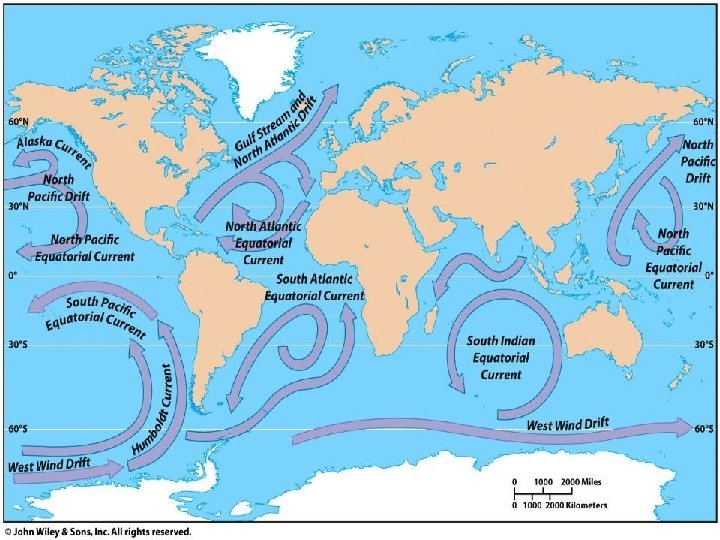
Ocean Currents • Created by same reasons as winds. • Distributes heat, nutrients, and DO. • Upwellings
 – Trade winds normally blow warm water off")
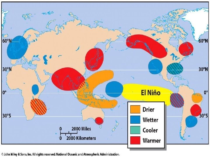
El Nino – Southern Oscillation (ENSO) – Trade winds normally blow warm water off the coast of South America and California (creates upwellings). – When winds fail, weaken, or change direction, the waters warm and stagnate. • Causes less productivity and possibly red tide. – As the Pacific surface temperature becomes warmer, global weather patterns are disrupted • First seen with wetter weather in eastern Pacific.

Climate and Weather • Climate • Winds

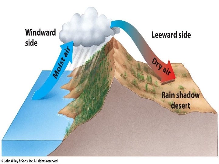
Rain Shadow Effect – AKA: Orographic Uplift – warm air rises and releases moisture on windward side of mountain. – air on leeward side is cooler and dry. – creates a distinctive microclimate on either side of mountain.

Microclimate Factors • Vegetation – affects humidity, winds, and creates shadows. – warmer in winter, cooler in summer. • Cities – buildings, asphalt, and vehicles raise temperatures and create haze and smog.

Plate Boundaries • Divergent • Convergent • Transform

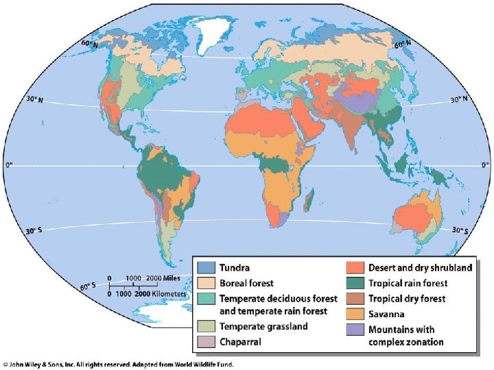
• Biomes – A large, relatively distinct terrestrial region with a similar climate soil, plants, and animals, regardless of where it occurs in the world • Typically determined by:
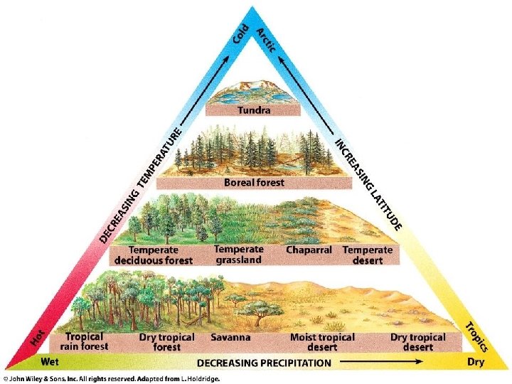

Tundras • Treeless biome in the far north with harsh, cold winters and extremely short summers • Precipitation • Temperature

Tundras • Nutrient poor soils with little organic material § Low species richness § Low primary productivity

Boreal Forests • A region of coniferous forests in the northern hemisphere • Growing Season • Precipitation

Boreal Forests • Soils are acidic and mineral poor • Vegetation comprised of drought resistant conifers § Mostly small animals • Aka:

Temperate Rainforests • Coniferous biome with cool weather, dense fog and high precipitation • Precipitation • Temperature
 •")
Temperate Rainforests • Soils are nutrient-poor, but high in organic material (dropped needles) • Dominant Vegetation • Variety of cool climate animal life • Very high species richness • Heavily logged

Temperate Deciduous Forests • Forest biome that occurs in temperate areas with a moderate amount of precipitation • Precipitation • Temperature

Temperate Deciduous Forests • Topsoil is rich in organic material and underlain by clay • Vegetation is primarily deciduous • Animals • Most of this biome land area has been regenerated after farming & timber harvest

Grasslands • Grasslands with hot summers, cold winters and too little precipitation to support trees • Precipitation • 90% of this biome has been lost to farmland

Grasslands • Soil has thick, organic material rich organic horizon • Periodic fires keep the dominant vegetation • Animals

Grasslands • North America • South America • Europe/Asia • Africa

Chaparrals • Also called a Mediterranean Climate • Temperature • Frequent fires

Chaparrals • Soil is thin and often not fertile • Vegetation • Animals

Deserts • Biome where lack of precipitation limits plant growth • Temperature • Precipitation

Deserts • Soils low in nutrients and high in salts • Sparse vegetation • Animals are very small to regulate temperature

Savannas • Tropical grassland with widely scattered trees • Temperature • Precipitation

Savannas • Soil low in nutrients due to leaching • Vegetation • Animals

Tropical Rainforests • Lush, species-rich biome that occurs where climate is warm and moist throughout the year • Precipitation • Very productive biome • Most species-rich biome

Tropical Rainforests • Ancient, weathered, nutrient-poor soil – Nutrients tied up in vegetation, not soil • Vegetation • Animals

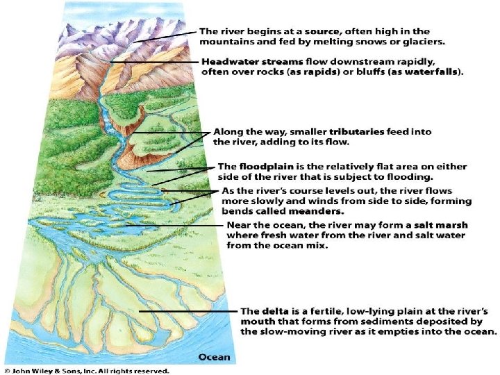
Freshwater Biomes – Freshwater comprises 1% of the world’s water but has 40% of the world’s fish species. – Two basic types: – Watershed/Drainage Basin

Lotic Water – Source Zone – Transition Zone – Flood Plain Zone •

• Littoral Zone Lentic Water • Limnetic Zone • Profundal Zone

Lentic Water • Thermal Stratification – Fall & Spring Turnovers – Summer Months

• Thermocline Lentic Water

Lentic Water – Oligotrophic Lakes – Eutrophic Lakes – Mesotrophic Lakes

Marshes and Swamps • Lands that shallow, fresh water covers for at least part of the year • Were once regularly filled in

Estuaries • Where freshwater and saltwater mix • Highly variable environment • Highly productive

– Oceans: Marine Biomes – Limiting Factors:

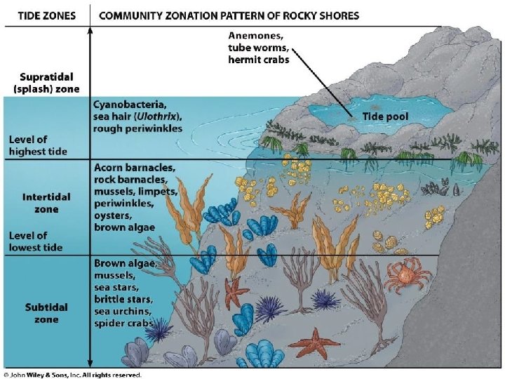
Marine Biomes • Coastal Zones • Sandy/Rocky Beaches • Intertidal Zone

Coral Reefs • Highest biodiversity in the ocean – “Oasis” of the ocean – Very sensitive to rising sea levels and temperatures – Coastal development and other human activities are destroying reefs

Open Ocean • Overall, lowest productivity of any other ecosystem • Euphotic Zone • Bathyl Zone • Abyssal Zone

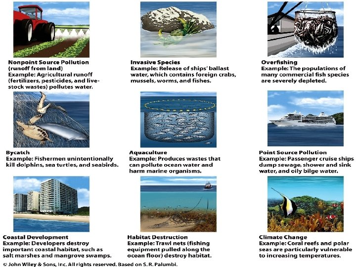
Ocean Pressures – ~40% of the world’s population lives within 100 km of a coast – Development has destroyed >50% of coastal wetlands and 1/3 of mangroves. – Fishing has damaged or destroyed habitats and severely decreased populations of fishes. – Global warming has had an immense impact on beach erosion and reef destruction.
- Slides: 65