Unit ii 10 Hrs surveying Various types of
 surveying")


 is the process by")


 Lasers")


 Bina Nusantara A global positioning system uses the characteristics")
 Application of GPS: • • Land, sea and air")


 are those")
 Transportation engineering")


 Ropeways and Cableways : 1. These are cable cars and carriages.")
 Belt conveyer : These are used for transportation of mineral ores, coals, grains")


 The vehicles are parked on the kerb or on")


- Slides: 90
Unit ii (10 Hrs. ) surveying
Various types of Maps and their uses A selective, symbolized and generalized representation of the whole or part of the earth at a reduced scale. Graphical representation of a very bigger land like land of city, land of nation to a greater scale such as 1 : 1000, 1 : 5000, 1 : 10000 etc. is called as map. A map is a graphic form, normally to scale of spatial abstraction of features on, or in relation to, the surface of the earth. TYPES OF MAPS • Surveying Maps • Thematic Maps 1. Surveying Maps: Following are the various types of surveying maps: a. Topographic maps b. Engineering maps c. Geographic maps d. Cadastral maps
a. Topographic maps: It shows natural and artificial features on the surface of the earth. Surveying done for this purpose is called topographic surveying. b. Engineering maps: This maps shows the details of engineering projects e. g. roads, dams, bridge. Surveying done for this purpose is called engineering surveying. Topographic maps Engineering maps
c. Geographic maps: These are about the political boundaries of the country and used by general public. d. Cadastral maps: These shows ownership rights of individual or communities. Surveying done for this purpose is called cadastral surveying. Cadastral maps Geographic maps
2. Thematic Maps or Special Maps: There are the special maps used for special purposes. A tool to communicate geographical concept such as distribution of population densities, climate, movement of goods, land use etc. is called as Thematic Maps.
Various uses of maps are listed below: 1. Maps are prepared to show countries, states, districts etc. avoid disputes. 2. Plans are prepared to record the property lines of private, public and governments (land records) help in avoiding unnecessary controversies. 3. Topo maps showing natural and man made features help in planning irrigation projects, flood control measures, road and railway routes, and other engineering projects. 4. Road maps help travelers to plan their programmes. 5. Locality plans helps in identifying houses and office locations. 6. Plans prepared after mine surveys help in systematically exploring mineral wealth. 7. Geological maps showing different strata in the earth crust help in selecting sites for Man made reservoirs. 8. Archaeological maps are prepared for unearthing relics of antiquity. 9. Military plans help in strategic planning. Thus, the maps prepared for various purposes are the basis for many engineering projects and useful in day to day life.
Introduction to digital mapping Digital mapping (also called digital cartography) is the process by which a collection of data is compiled and formatted into a virtual image. The primary function of this technology is to produce maps that give accurate representations of a particular area, detailing major road arteries and other points of interest. Though digital mapping can be found in a variety of computer applications, the main use of these maps is with the Global Positioning System, or GPS satellite network, used in standard automotive navigation systems.
Principles of planning To get accurate results one should follow the two basic principles explained below: 1. Working from Whole to Part In surveying large areas, a set of control points are identified and they are located with the highest precision. Then secondary control points are located using less precise methods. With respect to lines connecting secondary control points, the details of localized areas are measured and plotted. This is called working from whole to part. This principle helps in localizing the errors. If the surveying is carried out by adding localized areas one to other, the errors accumulate and the maps will be erroneous. 2. Fixing Positions of New Control Points For fixing new control points (stations) with respect to already fixed points, at least two independent processes should be followed. If A and B are two already located control points and with respect to them a new control point C is to be located, apart from the minimum measurements required as shown in Fig. , one more reading should be taken. Fixing of check lines and tie lines will also serve this process
Introduction to various survey instruments 1. For distance measurement: Chain: - 20 m, 30 m.
Introduction to various survey instruments Tape:
Introduction to various survey instruments For making survey stations: • • Ranging rod Plumb bob Pegs Arrow
Introduction to various survey instruments Ranging rod
Introduction to various survey instruments Plumb bob:
Introduction to various survey instruments Arrow:
Introduction to various survey instruments For setting right angles: • Cross staff • Optical square
Introduction to various survey instruments Cross Staff:
Introduction to various survey instruments Optical Square:
Introduction to various survey instruments For angular measurements: • • Prismatic compass Dumpy level Theodolite Tachometer
Introduction to various survey instruments Prismatic compass:
Introduction to various survey instruments Dumpy level:
Introduction to various survey instruments Theodolite:
Introduction to various survey instruments Advance surveying instruments: • • Electronics distance meter(EDM) Lasers Total station Digital Planimeter
Introduction to various survey instruments 1. Electromagnetic Distance Measurement EDMs are very useful in measuring distances that are difficult to access or long distances.
EDM instruments may be broadly classified into the following three types : 1. Infrared wave instruments 2. Visible light wave instruments 3. Microwave instruments.
2. Total Station A total station is an electronic/optical instrument used in modern surveying. The total station is an electronic theodolite (transit) integrated with an electronic distance meter (EDM) to read slope distances from the instrument to a particular point. Parts of Total Station
3. Laser theodolites and laser alignment instruments are also available for surveyors. The laser adaptor enables observer to centre the laser beam very accurately on the target Laser (Light Amplification by Simulated Emission of Radiation) alignment instruments produce a laser beam which is a visible straight line. They have wide range applications in alignment and setting out works of roads, railways, pipe lines, tunneling, mining and base line surveys. Laser attachments mounted on the telescope of theodolites are called as laser theodolite.
4. Digital Planimeter An electronic digital planimeter is used now a days to obtain the areas of irregular figures directly, accurately as well as quickly, which saves lot of time and labor. There are different types of digital planimeters such as X PLAN 360, PLANIX 5000.
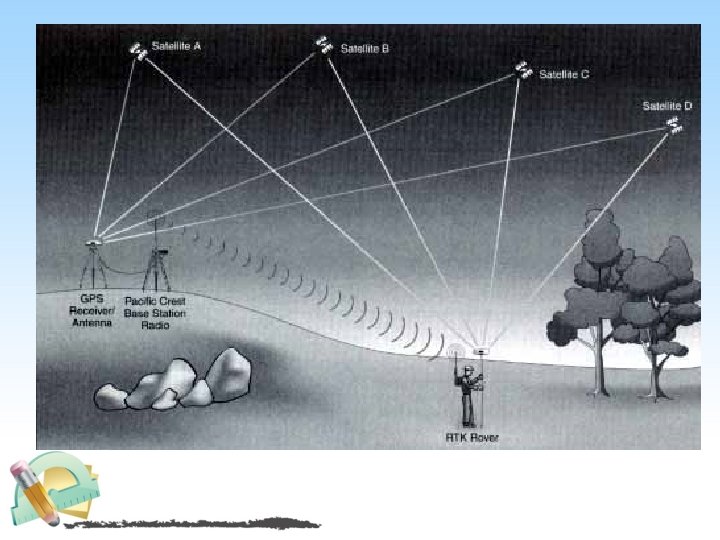
5. Global Positioning System (GPS) Bina Nusantara A global positioning system uses the characteristics of radio transmissions for location determination. Unlike previous navigation systems using ground based transmitters, satellite based transmitters are used to cover earth with higher accuracy that available from the land based systems. The satellites transmit timing information, satellite location information and satellite health information. The Space Segment is technical term for the satellites that belong to the system. The user requires a special radio receiver a GPS receiver to receive the transmissions from the satellite. The GPS receiver contains a specialized computer that calculates the location based on the satellite signals. The user does not have to transmit anything to the satellite and the satellite does not know the user is there. There is no limit to the number of users that can be using the system at any one time. The users with their receivers are known as the User Segment. The satellites are controlled and monitored from ground stations (the Control Segment). The control stations monitor the satellites for health and accuracy. Maintenance commands, orbital parameters and timing corrections are uploaded from the ground on a periodic basis.
5. Global Positioning System (GPS) Application of GPS: • • Land, sea and air navigation. Vehicle tracking Search and resource operation Military application. Bina Nusantara
Fig. 10 Theodolites
6. Geographical information system Maps are used as the languages of simple geography. Importance of map making is recognized long ago. Surveyors went round the land prepared maps. Data required for locating and calculating extent of a place/region is called spatial data. Physical properties and human activities related to a place/region are stored in the form of tables, charts and texts. This information is called attribute data. Referring to maps/plans and then to attribute data stored in hard copies like books is time consuming updating and managing the data is difficult. This problem is overcome by combining spatial data and attribute data of the location by appropriate data base management in computers. The location information (spatial data) is digitized from available maps and stored in computers. For this data structure used is either raster data or vector
6. Geographical information system Application of GIS: • • Location of engineering structures. The study of alternative sites. Layout of residential areas. Location of various utilities.
7. Theodolite A theodolite a precision instrument for measuring angles in the horizontal and vertical planes. Theodolites are mainly used for surveying applications, and have been adapted for specialized purposes in fields like metrology and rocket launch technology. A modern theodolite consists of a movable telescope mounted within two perpendicular axes—the horizontal or trunnion axis, and the vertical axis. When the telescope is pointed at a target object, the angle of each of these axes can be measured with great precision, typically to seconds of arc.
Theodolites may be either transit or non-transit. Transit theodolites (or just 'Transits') are those in which the telescope can rotate in a complete circle in the vertical plane Non transit theodolites are those in which the telescope can rotate only in a semicircle in the vertical plane. Some types of transit theodolites do not allow the measurement of vertical angles. The builder's level is sometimes mistaken for a transit theodolite, but it measures neither horizontal nor vertical angles. It uses a spirit level to set a telescope level to define a line of sight along a level plane. Tripod Leveling rod
Unit ii (10 Hrs. ) Transportation engineering
ØTransportation means the movements of the people and materials from one place to another. Ø Transportation engineering is a branch of civil engineering which deals with the study, design and construction of roads, railways, bridges, tunnels, waterways, seaways and airways. ROLE OF TRANSPORTATION IN NATIONAL DEVELOPMENT 1. 2. 3. 4. 5. A good system of transportation is very essential for the rapid economic, industrial and cultural growth of a country. As blood transportation through arteries of the body is essential for the human welfare, so also a similar good system of transportation is essential for national welfare. For rapid growth of a country, good net work of communication is essential. It is the back bone of overall progress of a country. Utilization of natural resources lying unutilized in different hills, mountains, forests and mines. Supply of Raw materials, fuel and machineries to different industries.
5. To raise the production of raw materials, fuels and machineries etc. by providing market to it. 6. Widens the size of the market. 7. Facilitates establishment of industries in backward areas 8. Solves the problem of unemployment in rural areas 9. Protect the people from the difficulties of war, natural calamities and other problems. 10. Establish relationship among different parts of the people and strengthens the feeling of unity and brotherhood.
MODES OF TRANSPORT § Road ways § Railways § Air ways § Water ways § Other means of Transport
1. Road ways • Roadways provide a channel for movement of people and goods between various centres of the city. • Roads can be used by all types of vehicles such as bullock carts, carriages, rickshaws, cycles, scooters, jeeps, cars, buses, lorries etc. • In emergencies such as accidents, the injured person can be rushed to the hospital by way of roads only. • During floods and draughts, roads are found to be a great boon in transferring the basic commodities efficiently. • They are equally useful during movements of the defense force.
2. Railways 3. 1. It is a convenient mode of transport for travelling long distances. 2. They carry heavy and bulky materials. 4. It is relatively faster than road transport. 5. Now a days underground railways also called tubeways are coming into practice. Metro Rail is again a faster mode of transport. They are called permanent ways since the steel rails are laid permanently along the route on which the train runs.
3. Airways 1. These include aeroplanes, helicopters, air crafts, jet planes etc. It is the fastest method of travel. 2. They are useful for quick transport of perishable foods and valuable goods. 3. They require constructions of run ways, control tower, terminal buildings, hangars etc. Hence, the cost of construction and maintenance is high. 4. The hot air balloons are also used for air travels, but are suitable for short distances.
4. Waterways 1. 2. 3. 4. 5. 6. 7. 8. It promotes international trade. They transport the goods through seas and oceans from one harbour to other. They require constructions of ports, docks, harbours, break waters, light houses etc. They also carry large volume of bulky goods. The transportation is by ships, boats and steamers. They consume more time. These are the cheapest form of transport and include navigation on rivers, lakes, sea, ocean etc. It is a safe mode of transport with respect to occurrence of accidents. The cost of maintaining and constructing routes is very low most of them are naturally made.
5. Specialways (a) Ropeways and Cableways : 1. These are cable cars and carriages. 2. They run through overhead cables and ropes hung between 3. two short distance stations. They are generally used for transportation of men and materials in hilly or mountainous area. They are also useful to carry coals, mine ores, sand etc. 4. These are generally adopted when the usual methods transportations are not possible. of
(b) Belt conveyer : These are used for transportation of mineral ores, coals, grains etc. They are also suitable for the movement of the people in crowded parts of the city. (c) Pipe lines : The pipe lines are useful for transport of liquid and gases, petroleum products, water and sewage etc.
CLASSIFICATION OF HIGHWAYS 1. Expressways 2. National Highways 3. State Highways 4. Major District Roads 5. Other District Roads 6. Village Roads
1. Expressways Mumbai Pune Expressway 1. A new category Express Highways is suggested in the Third Road Development Plan (1981 2001) (20 Year Road Plan). 2. These are meant to function as divided arterial highways for the movement of moving motor traffic under free flow condition in big metropolitan cities like Mumbai, Kolkata, Delhi, Chennai. 3. They have the highest design speed. 4. They connect major centres of traffic generation and intended to serve trips of medium and long length between large residential areas, industrial or commercial concentrations and the central business districts (C. B. D. ). 5. Two or three such express highways are necessarily to be provided around big cities of modern days to face the tremendous growth of traffic.
4. They have at least four lanes and are generally provided with divided carriage way, controlled access, grade separators at intersections and fencing. 5. Express highways are designed with easy gradients and smooth curves so as to carry traffic speedily and safely. 6. These are comparable next to railways in cost and carrying capacity of traffic. 1. As per the restrictions, the speed of the vehicles should never be less than specified minimum limit while travelling on the express highway. 2. They are therefore, restricted only for very fast moving vehicles. 3. Parking, loading, un loading of goods and pedestrian traffic are not permitted on these express highways.
1. 2. National Highways 2. 3. 4. 5. 6. NH 7 : - Length: 2, 369 km From Varanasi to Kanyakumari Route: Varanasi> Jabalpur> Nagpur> Hyderabad> Bangalore> Madurai> Kanyakumari 7. 8. They run through the length and breadth of the country. They connect all national capitals with state capitals, major cities, towns, border areas. These are considered as arteries of the communication system in the country. They are more important from strategic point of view. They also connect neighbouring countries. They should have at least two traffic lanes and good surface finishing and excellent strength to carry heavy traffic. The construction and maintenance of these roads are usually carried by the Central Government. All the national highways are assigned numbers for example highway connecting Chennai Belgaum Pune Mumbai is called N. H. 4 ; Mumbai Ahemdabad Jaipur Delhi is called N. H. 8 ; Madurai Rameshwaram is called N. H. 49 and so on.
TYPICAL CROSS SECTION OF NATIONAL HIGHWAY
3. State Highways 1. These are the main roads running within the states. 2. They connect the important towns, and cities of the state with national high ways and highways of neighbouring states. 3. They generally have one lane but two lanes are always preferred. 4. They have modern type of bituminous or concrete surfacing. 5. They are considered as the main arteries of the communication system of the state. 6. The construction and maintenance are usually carried by the state government by taking grants from central government. 7. Total length of all SH in the country is 1, 37, 119 Kms. Andhra Pradesh State Highways
4. Major District Road 1. These roads connect all the districts, all production areas and markets with state high way or national high way or railways. 2. They also further connect the Taluka places within the district. 3. They have a single metalled lane of traffic. 4. They have modern type of surfaces. 5. India has a total of 4, 70, 000 kms of MDR.
5. Other District Roads 1. These are also called as minor district roads. 2. These are roads connecting a particular town to a town or a village with some other roads. 3. They have some lower specifications than major district roads and state highways. 4. These roads should have good metalled surface, proper drainage and should be accessible throughout the year. 5. They possess much importance because they provide direct link to the villages and serve a large rural population, as such they should be motorable throughout the year. 6. They establish connections with major district roads and state highways. 7. The construction and maintenance are carried by the district authorities or Zilla Parishad. (Z. P. ).
6. Village Roads 1. These are meant mainly for village use. 2. These roads connect a village to a village or a village to a district or a taluka headquarters. 3. These are generally stabilized earth roads but the metal surface is preferable to serve more useful purpose. 4. The construction and maintenance are carried by the local district boards. 5. There are more than 2, 25, 000 km long village roads in the state of Maharashtra. 6. India has 26, 50, 000 kms of ODR+VR out of the total 33, 15, 231 kms of all type of roads.
Pavement
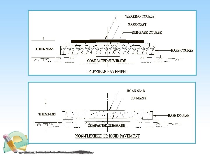
PAVEMENT Definition : Pavement is the durable surface material laid down on an area intended to sustain vehicular or foot traffic, such as road or walkway. Types of Pavements : - • Flexible Pavement • Rigid Pavement
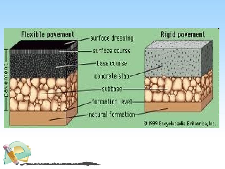
1. Flexible Pavement The road pavements, which can change their shapes to some extent without rupture, are known as flexible pavements. Any change of shapes occurring in the sub grade and subsequent layers on it, is reflected by the top surface of the pavement. Water bound macadam (WBM) pavement are the examples of flexible pavements. 2. Non Flexible or Rigid Pavement The road pavements which cannot change their shape without rupture are known as Non flexible or rigid pavement. Any change occurring in the shapes of the sub grade is not reflected by the surface of these pavements. Cement concrete road pavements are the example of rigid pavements.
FLEXIBLE PAVEMENT RIGID PAVEMENT
DIFFERENCE BETWEEN FLEXIBLE AND RIGID PAVEMENT Flexible Pavement Rigid Pavement 1. Deformation in the sub grade is transferred to the upper layers 1. Deformation in the subgrade is not transferred to subsequent layers 2. Design is based on load distributing characteristics of the component layers 2. Design is based on flexural strength or slab action 3. Have low flexural strength 3. Have high flexural strength 4. Load is transferred by grain to grain contact 4. No such phenomenon of grain to grain load transfer exists 5. Have low completion cost but repairing cost is high 5. Have low repairing cost but completion cost is high 6. Have low life span 6. Life span is more as compare to flexible 7. Surfacing cannot be laid directly on the sub grade but a sub base is needed 7. Surfacing can be directly laid on the sub grade
8. No thermal stresses are induced as 8. Thermal stresses are more vulnerable to the pavement have the ability to be induced as the ability to contract and expand freely expand is very less in concrete 9. expansion joints are not needed 9. expansion joints are needed 10. Strength of road is highly 10. Strength of road is less dependent on the strength of the sub grade 11. Rolling of surfacing is needed 11. Rolling of surfacing is not needed 12. Road can be used for traffic within 12. Road cannot be used until 14 days of 24 hours curing 13. Force of friction is less 13. Force of friction is high
TRAFFIC SIGNS AND SIGNALS
TRAFFIC SIGNS Traffic signs perform a number of functions: • They give timely warning of hazardous situation when they are not self evident. • They are of great help in regulating traffic by imparting messages to the drivers about the need to stop, give way and limit their speeds. • They give information as to highways routes, directions and points of interest. Signs are divided into three categories: regulatory, warning and guidance signs to: • Warn you of hazards ahead that would otherwise be difficult to see. • Guide you to your destination by clearly identifying the route. • Regulate traffic speed and movement. The signs are manufactured in different shapes and colors to convey a particular message.
• Regulatory Signs These signs are seen at intersections to regulate traffic flow.
• Regulatory Signs are meant to inform the road user of certain laws, regulations and prohibitions. The violation of these signs is a legal offence. Example : • Stop and give way sign • Prohibitory signs • No Parking signs • Speed limit and vehicle control signs • Restriction end sign • Compulsory direction control and other signs
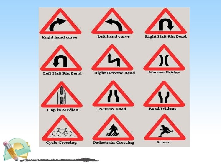
• Warning Signs • Warning or cautionary signs are used to warn the road user of certain hazardous conditions that exists on or adjacent to the roadway. • The warning signs are in the shape of a equilateral triangle with its apex pointing upwards. • The warning signs are to be located at sufficient distance in advance of the hazard warned against; these distances are 120, 90, 60, and 40 m respectively on NH/SH, MDR, ODR, and VR. On urban road the distance is 50 m
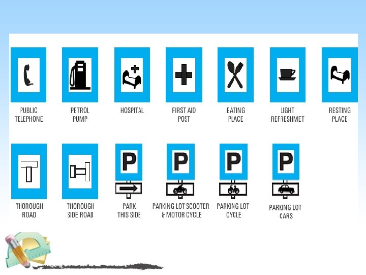
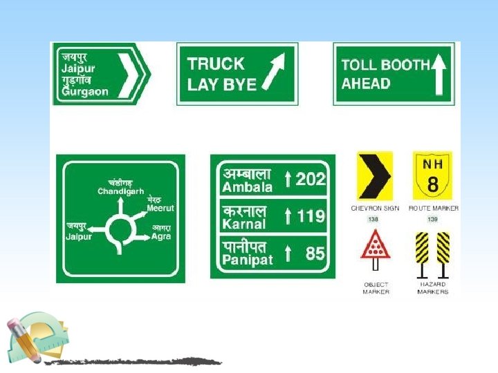
• Guide Signs Or Informatory Signs: • These signs are used to guide the road user along routes, inform them of destination and provide with the information to make travel easier, safe and pleasant. Example : • Direction and place identification Sign • Facilities Information Signs • Other Useful information Signs • Parking Signs • Flood gauge
TRAFFIC SIGNALS • Signals • Fixed Time • Manually Operated • Traffic actuated • Pedestrian • Special Traffic
• Definition: Traffic Signals are control devices which could alternately direct the traffic to stop and proceed at intersections using red and green traffic light signals automatically.
�Advantages of Signals: 1. Signal is provided at intersection to manage the traffic flow. 2. Signals provide safety to vehicular traffic and pedestrian. They reduce and avoid the accidents. 3. Signals are easy to understand compare to traffic police management at intersection. �Disadvantages of Signals: 1. Fast moving vehicles may cause rear end collision at signalised intersection 2. Improper design of signal cycle length can cause fixed delay. 3. Duration off peak hour unnecessary delay occur at signalised intersection.
Types of Traffic Signals • Fixed Time Signals: are set to repeat regularly a cycle of red, amber and green lights. The timing demand to clear off the intersection with the help of detectors which are installed at the approaches. These are very costly. • Traffic actuated Signals: are those in which the timings of the phase and cycle are changed according to traffic demand to clear off the intersection with the help of detectors which are installed at the approaches. They are very costly. • Pedestrian Signals: are meant to give the right of way to pedestrians to cross a road. The vehicular traffic should be stopped by red or stop signal on the traffic signal of the road.
• Manually operated Signals:
• Special Traffic Signals:
PARKING SYSTEM • Types of Parking System üOn Street Parking üOff Street Parking
ON –STREET PARKING (KERB PARKING) The vehicles are parked on the kerb or on the side of street or road. Types of Kerb Parking: 1. Parallel Parking 2. Angle parking
On –street parking : Parallel parking 1. Parallel parking is a method of parking a vehicle in line with other parked 2. 3. 4. 5. vehicles. Vehicles parked in parallel are in one line, parallel to the kerb, with the front bumper of each facing the back bumper of the next. Parallel parking allows a vehicle to park in a smaller space than would be true of forward parking. Parallel parking requires initially driving the vehicle slightly past the parking space followed by reversing into the space. Subsequent position adjustment may be required by the use of forward and reverse gears.
1. Angled parking is on street parking in which the vehicle has it's front closest to the curb. 2. Angled parking uses less linear curb length per parking space than traditional parallel parking so more spaces can be provided on the same block.
Types of Angle parking : • 30 0 angle parking • 60 0 angle parking • 45 0 angle parking • 90 0 angle parking
OFF – STREET PARKING § When parking facility is provided at a separate place away from the kerb it is known as off street parking. § Off street parking is an important part of the transportation system. § It is an efficient means of storing vehicles while they are not in use, and it causes little disruption to the neighboring roadways. § Additionally, since parking is the terminal or destination for a trip, the availability of off street parking can affect the attractiveness of destinations as well as transportation modes.
§ Off street parking facilities range from: § Car garage in the home To § Multi story garages § Off street parking becomes a necessity wherever the need for vehicle parking exceeds the capacity of on street parking. Types of off street parking: • Surface parking lots • Multi floor parking garages
Off –street parking : Surface Parking lots • A parking lot also known as car lot, is a cleared area that is intended for parking vehicles. Usually, the term refers to a dedicated area that has been provided with a durable or semi durable surface. • In most countries where cars are the dominant mode of transportation, parking lots are a feature of every city and suburban area. • Shopping Malls, sports stadiums, mega churches and similar venues often feature parking lots of immense area.
Off –street parking : Mega Floor parking garages
CAUSES OF ACCIDENTS
Thank you Any