UNIT I The Nature Perspectives of Geography Definition


")


 = spatially close 2. Dispersed (Scattered)")


 region: defined by a uniform characteristic Exs: a")
 region: defined by interactions Ex: magazine circulation, radio station’s range, a")
 Region: ideas or emotions of an area Exs: the South the")


 Conic Projection")


 Choropleth (by region:")


")


 mental maps: representations of our own image of the world")

: computer programs that collect layers of spatial data")


- Slides: 62
UNIT I: The Nature & Perspectives of Geography
Definition of Geography • human & physical features • spatial perspective looking at patterns & distributions • invented by Greeks: Eratosthenes “geo”: Earth “graphy”: writing
Basic Geo Ques. : • How are places related? • How are places inter-connected? • How are humans affected? “THE WHY OF WHERE!!!”
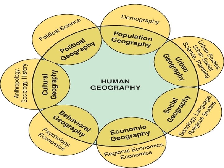
• Human Geo: study of the spatial organization of human activities • how we organize space & place • where & why human activities are located
Location absolute location: latitude & longitude; street address relative location: expressing a location in relation to another site
Site: the physical character of a place Situation: the location of a place relative to other places Fig. 1 -7: Singapore is situated at a key location for international trade.
Place place: location with physical & cultural attributes “sense of place”: infusing a place with meaning & emotion
Perception of Place Where Pennsylvanian students prefer to live Where Californian students prefer to live
The Cultural Landscape • natural landscape modified by human activities • the “Built Environment” Religion and cremation practices diffuse with Hindu migrants from India to Kenya.
Spatial analysis: the study of geographic phenomena the SPATIAL: 1. Distance 2. Accessibility 3. Connectivity
1. Distance Decay • interaction diminishes as distance increases “friction of distance” closer = more interaction
Distance Decay Curve (“j-curve”)
place utility: a place’s usefulness to a particular person or group
2. Accessibility How easy/difficult to overcome the friction of distance?
3. Connectivity • level of interaction • communication & transportation Ex: Telephone Lines, streets, pipelines, radio, TV, internet
Ullman’s Spatial Model of Interaction 1. Complementarity: supply & demand between places
2. Transferability: ability to acquire item
3. Intervening Opportunity: closer location develops = more interaction
Diffusion: - spread of an idea or innovation from its hearth Barriers to diffusion? - physical - distance decay - cultural barriers
1. Expansion Diffusion: spreads outward from the hearth a. contagious: spreads adjacently b. hierarchical: spreads from big city to smaller places
Cultural Diffusion in action Ex: Because Hindus believe cows are holy. . Mc. Donalds restaurants in India feature veggie burgers.
2. Relocation Diffusion: permanent movement of individuals who carry an idea Paris, France Kenya
Spatial Distribution • elements common to all spatial distributions : Density, Dispersion, & Pattern
Density • quantity within a defined unit of area
Dispersion • How spread out? 1. Clustered (Agglomerated) = spatially close 2. Dispersed (Scattered) = spread out
Pattern • The geometric arrangement in space • Types of Patterns: Linear, Clustered, & Random
Linear Pattern • typically depict houses along a street or towns along a railroad
Clustered Pattern • typically involve items concentrated around a single node • Ex: Center City with surrounding suburbs
Random Pattern • An unstructured irregular distribution
Levels of Scale - local - regional - national - global
Scale
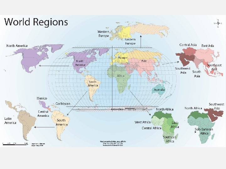
“REGIONAL APPROACH” Latin America Sub-Saharan Africa Southeast Asia
Types of Regions 1. Formal (Uniform) region: defined by a uniform characteristic Exs: a country’s border a language region
2. Functional (Nodal) region: defined by interactions Ex: magazine circulation, radio station’s range, a downtown CBD
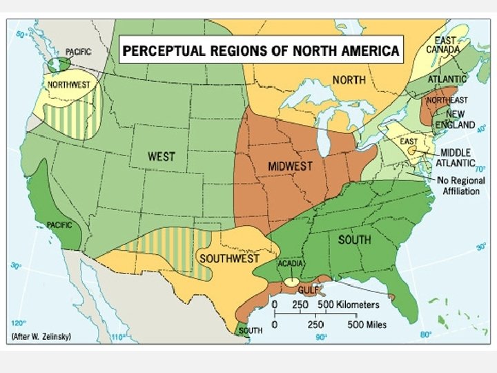
3. Perceptual (Vernacular) Region: ideas or emotions of an area Exs: the South the Middle East Chinatown Little Italy
In Montgomery, Alabama, streets named after Confederate President Jefferson Davis and Civil Rights leader Rosa Parks intersect.
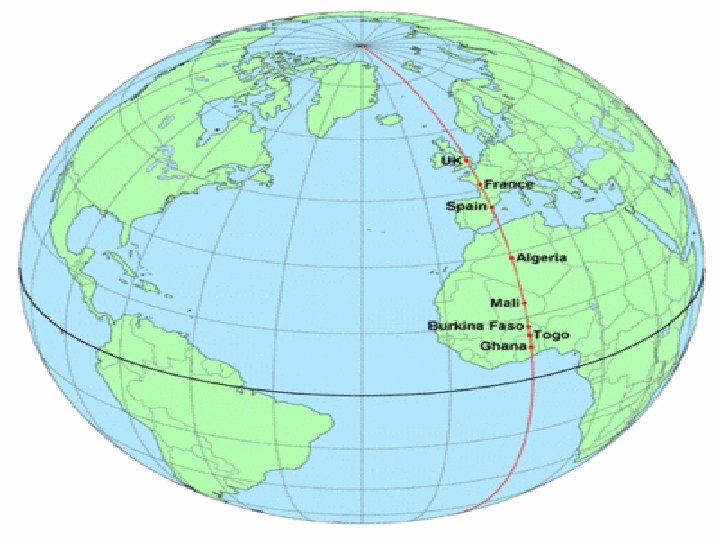
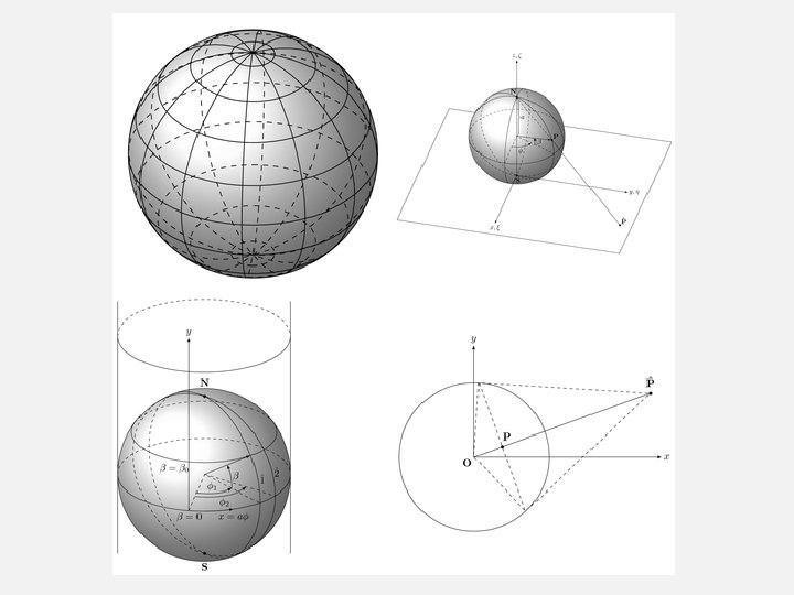
1. Globe Grid: based upon latitude-longitude 2. Map Projections: making a flat map of a round surface * All maps have distortion!
World Geographic Grid The world geographic grid consists of meridians of longitude and parallels of latitude. The prime meridian (0º) passes through Greenwich, England
Cylindrical Projection Planar Projection (Azimuthal) Conic Projection
The Robinson Projection
Which is the small-scale map? Neighborhood in Edmonton City of Edmonton Small scale: more area, less detail Large scale: less area, more detail
Two Types of Maps: Reference Maps Thematic Maps - Show locations - General purpose - “Tells a story” - Uses Data - Pattern, distribution Ex: street maps
Reference Map
Thematic Maps TYPES: Graduated Circle Dot-Distribution Isopleth (isolines: weather, topographic maps) Choropleth (by region: county, state)
Graduated Circle Map • different sizes to show frequency
Dot Map
Isopleth Map • The isoline connects values
Examples of topographic maps (shows elevation through contour lines)
Choropleth Map
Thematic Map What story about median income in the Washington, DC area is this map telling?
Mental maps (“cognitive” maps) mental maps: representations of our own image of the world
Activity Space: the places we travel to in our daily activities – How are activity spaces and mental maps related?
Geographic Information System (GIS): computer programs that collect layers of spatial data
Remote Sensing: collecting data through satellites
Measuring Spatial Interaction The Gravity Model: How size & distance affect interaction