Unit 7 Urban Patterns Borcherts Epochs Stages of

Unit 7 Urban Patterns

Borchert's Epochs Stages of Evolution of American Metropolis John Borchert’s fascination with geography can be traced to his connection to Chicago. This connection lead to a lifetime of study of America’s heartland the unique geographical elements found there. John’s lifetime of study was published as America’s Northern Heartland. As a tribute to Dr. Borchert, his family has created a website. Along with most of his published works there is a collection of his unpublished works and the entire text of America’s Northern Heartland. http: //www. borchert. com/john/index. htm

Borchert’s Epochs refer to four distinct periods in the history of American urbanization. Each epoch is characterized by the impact of a particular transport technology on the creation and differential rates of growth of American cities. A. Cities have different atmospheres 1. Once established, a city tends to survive even change and modernize 2. Four-stages in the evolution of the American metropolis a) Sail-wagon epoch (1790 -1830) b) Iron-horse epoch (1830 -1870) c) Steel-rail epoch (1870 -1920) d) Auto-air-amenity epoch (1920 -1970) Borchert did not provide an ending date for his fourth epoch. It has been suggested that today Borchert would probably add a fifth stage: e) High-Technology Epoch (1970 to present)

Over the last five decades urban growth rates have been highest in: A. LDCs. B. MDCs. C. the United States. D. northern Europe. E. Australia. 15

13 -02 Over the last five decades urban growth rates have been highest in: A. LDCs. B. MDCs. C. the United States. D. northern Europe. E. Australia Explanation: LDCs host eight of the ten most populous cities and their growth is being sped by rural migration and natural increase.

Urban Settlements Urbanization Worldwide Increasing urban percentage & populations Megacities: cities of 10 million or more people City-States: a city that is also a country. E. g. Singapore, Vatican City, and many old kingdoms of the world.

Urban Settlements Urbanization in U. S. United States: Define Megalopolis. The Boston– Washington corridor contains about one-quarter (25%) of U. S. population on 2% of U. S. land area!

Most Concentrated Area for U. S. Cities: Megalopolis The Boston–Washington corridor contains about one-quarter of U. S. population – on 2% of U. S. land area! This area is called Megalopolis. LA to San Diego into Mexico could qualify as well.

Large Cities with 3 million or more people. Many qualifying cities are NOT shown.

Note that of the 50 largest cities in the world, 5 of them are in Africa.

The _______ model holds that cities expand outward in circular rings. A. concentric zone B. edge city C. sector D. multiple nuclei E. peripheral 15

The _______ model holds that cities expand outward in circular rings. A. concentric zone B. edge city C. sector D. multiple nuclei E. peripheral Explanation: Other urban models suggest that cities grow in sectors and discrete nuclei or around specific nodes or transportation routes.
 Concentric zone model")
Urban Structure 4 main models of urban structure (Mostly North American) Concentric zone model Sector model Multiple nuclei model “Peripheral Model” - NEW

Concentric Zone Model In the concentric zone model, a city grows in a series of rings surrounding the CBD.

Bid Rent Theory The bid rent theory is a geographical economic theory that refers to how the price and demand for real estate changes as the distance from the Central Business District (CBD) increases. It states that different land users will compete with one another for land close to the city center. This is based upon the idea that retail establishments wish to maximize their profitability, so they are much more willing to pay more money for land close to the CBD and less for land further away from this area. This theory follows the reasoning that the more accessible an area (i. e. , the greater the concentration of customers), the more profitable. Based on Concentric Zone Model

Sector Model In the sector model, a city grows in a series of wedges or corridors extending out from the CBD.

A. B. C. D. E. According to the sector model of North American city structure, members of low-income groups tend to live in which of the following places? The inner city only Linear residential areas radiating from the center city outward Peripheral temporary settlements Evenly dispersed throughout the urban area 20 The suburbs and

Multiple Nuclei Model The multiple nuclei model views a city as a collection of individual centers, around which different people and activities cluster. It emphasizes the decreasing role the traditional CBD holds in modern cities.

Peripheral Model of Urban Areas What city does this remind you of? The central city is surrounded by a ring road, around which are suburban areas and edge cities, shopping malls, office parks, industrial areas, and service complexes.

Urban Realms Model www. csiss. org James E. VANCE Jr cities are made up of small "realms" which are self-sufficient urban areas with independent focal points. 1964 Modeled after cities like San Francisco, Atlanta and Los Angeles Further metamorphosis of multiple nuclei model (update) This model does a good job at explaining suburban growth and how certain functions that are normally found in the CBD can be moved to the suburbs (such as shopping malls, hospitals, schools, etc. ). These functions diminish the importance of the CBD and instead create distant realms that accomplish approximately the same thing.

Dwelling patterns in less-developed countries: A. vary dramatically based B. C. D. E. on ancient cultural practices. tend to be similar to European cities. tend to be similar to American cities. are strongly regulated by governments. lead to strong intermixing of rich and poor in the city centers. 15

13 -05 Dwelling patterns in less-developed countries: A. vary dramatically based on ancient cultural practices. B. tend to be similar to European cities. C. tend to be similar to American cities. D. are strongly regulated by governments. E. lead to strong intermixing of rich and poor in the city centers. Explanation: Most LDC cities have a colonial past and, like European cities, the poor and worker predominate in the suburbs.

Differences Between U. S. and European Cities Top professionals in Glasgow, Scotland, are more likely to live near the center of the city, in contrast to most U. S. cities, where the wealthy mostly live in suburbs.

Suburban Development in the U. S. and U. K. New housing in the U. K. is likely to be in planned new towns (in a compact manner). I also noticed this while flying over Canada. On the other hand, growth in the U. S. occurs in discontinuous developments.

Latin American City Model Similar to European cities, many Latin American cities, the wealthy live in the inner city and in a sector extending along a commercial spine, while the poor live on the outskirts of the city (or “suburbs”). The Latin American model is in direct contrast to the U. S. , where the poor tend to live close to downtown, and the wealthy live in the suburbs. This model was developed by: Dr. Larry Ford

In Latin American cities, the very poor tend to live: A. in the central business B. C. D. E. district. on the periphery of the city. in narrow corridors radiating out from the central business district. in a ring that immediately surrounds the central business district. in edge cities physically 15

13 -06 In Latin American cities, the very poor tend to live: A. in the central business district. B. on the periphery of the city. C. in narrow corridors radiating out from the central business district. D. in a ring that immediately surrounds the central business district. E. in edge cities physically separated from large cities. Explanation: Like other cities in LDCs, the poor cluster on the margins in squatter settlements.

Participant Leaders Points Participant

There were many Pre-Colonial Cities in Africa, many of which STILL do exist as the modern cities of today. This photo shows the ruins of the Great Zimbabwe, which existed prior to the colonial period. Some pre-colonial cities that still exist today include Ibadan, Kano, etc (Nigeria); Timbuktu (Mali); Kumasi (Ghana), and so on.

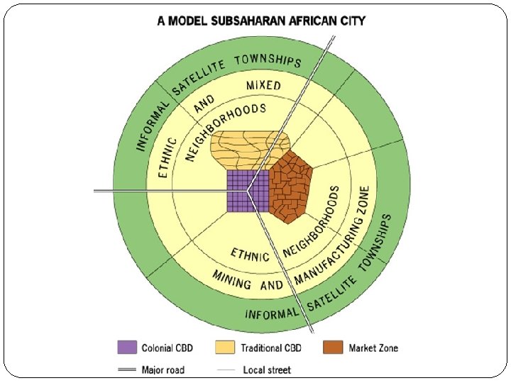
The “Dual City” Phenomenon Most African cities tend to be “dual cities”. This is mainly as a result of the presence of a traditional city center and colonial/modern (Western) city center in existence within the same city. So, most large cities in Africa tend to have “two or three downtowns” – the Traditional and Modern, and sometimes Colonial. This phenomenon was first recognized by Professor Mabogunje (1968), at the University of Ibadan, Nigeria.
, Morocco This pre-colonial old city in North Africa has narrow winding streets")
Fès (Fez), Morocco This pre-colonial old city in North Africa has narrow winding streets and dense population. The French laid out a new district to the west with a geometric street pattern (thus showing a “dual city” pattern).

The following few slides contain photographs of some of today’s African cities (unfortunately usually not seen in popular media). This photo shows a section of Nairobi, Kenya.
")
The City of Abidjan, Cote d’ Ivoire (Ivory Coast)

Top: Windhoek, Namibia Bottom: Nairobi, Kenya
")
Modern Cairo, Egypt (Africa)
, Nigeria")
Lagos Island (Eko), Nigeria
")
The alignment of ancient Chinese cities toward the cardinal directions (N, S, E, W) best illustrates the importance of which of the following factors in the shaping of these early cities? A. Topography B. Economics C. Gender D. Technology E. Belief systems 15
, the")
Asian: Ho Chi Minh City, Vietnam In Ho Chi Minh City (formerly Saigon), the French demolished the previous city and replaced it with a colonial design with boulevards and public squares.

International company headquarters, significant global financial functions, and a polarized social structure are defining characteristics of A. primate cities B. world cities C. forward capitals D. entrepots E. edge cities 15

Rank-Size Distribution in the United States and Indonesia Figure 12 -23 1/N Rule

Why Do Business Services Cluster in Large Settlements? Hierarchy of business services Services in world cities Business: clustering of services is a product of the Industrial Revolution Consumer: retail services with extensive market areas May include leisure services of national importance due to large thresholds, large ranges, and the presence of wealthy patrons. Public: world cities are often the center of national or international political power

World Cities Figure 12 -25

An urban center that is disproportionately larger than the second largest city in a country and that dominates the country’s social, political, and economic activities can be best classified as A. a megalopolis. B. a conurbation. C. a primate city. D. an edge city. E. an imperial city. 15

Problems of Urbanization Problems in foreign countries Primate Cities: a large city more that twice as large as the next largest city, usually with a large proportion of the national city population, e. g. Mexico City, Lagos (Nigeria), Bangkok (Thailand), Paris (France), London (England), etc. They are usually the cultural, economic and political center for the entire country. Cities usually become ‘primate’ (large) because too much attention is given to that particular city at the expense of others. Therefore it grows at the expense of other towns, and ends up drawing more immigrants from the countryside who are looking for work. This then leads to problems shown on next slide, especially in developing countries.

The problems of urbanization include urban primacy, housing, sanitation, traffic, unemployment, inadequate services, etc. Problems in this city (Lagos) are similar to those you will find in South America or Asia.

The process by which an inner-city neighborhood is renovated and attracts middle-class residents is called: A. annexation. B. gentrification. C. public housing. D. redlining. E. urbanization. 15

13 -08 The process by which an inner-city neighborhood is renovated and attracts middle-class residents is called: A. annexation. B. gentrification. C. public housing. D. redlining. E. urbanization. Explanation: Renovated housing stock leads to higher tax receipts for cities as well as higher rents that in turn displace poorer residents.

Why Do Inner Cities Face Distinctive Challenges? Inner-city physical issues Most significant = deteriorating housing Filtering: Process of subdivision of slowly deteriorating houses and occupancy by successive waves of lower-income people. Redlining: Process by which banks draw lines on a map and refuse to lend money to purchase or improve property within the boundaries. Urban renewal: Program in which cities clear inner-city neighborhoods and sell to private developers to improve. Public housing: Govt. housing, 30% of family’s income. Renovated housing Gentrification: Process of converting an urban neighborhood from a low-income, to middle-class.

Why Do Inner Cities Face Distinctive Challenges? Inner-city social issues The underclass An unending cycle of social and economic issues Homelessness Culture of poverty

Why Do Inner Cities Face Distinctive Challenges? Inner-city economic issues Eroding tax base Cities can either reduce services or raise taxes Impact of the recession Housing market collapse

All of the following have helped create ghettos in North American cities EXCEPT A. blockbusting and B. C. D. E. racial steering redlining by financial institutions concentration of public housing and social services fixed school district boundaries Economic Enterprise Zones 15
 illustrates the integration of heavy")
Public Transport in Brussels This figure of Brussels (Belgium) illustrates the integration of heavy rail and light rail in public transport, which might reduce the need for driving individual cars. New York City is trying to work in that direction too.
 Local government fragmentation Numerous small independent local governments")
Problems of Suburbs (and Some Solutions) Local government fragmentation Numerous small independent local governments e. g. Elkhorn (before annexation), are a problem for U. S. urban planning. No-one wants to plan in a coordinated fashion (unless they’re annexed). Solutions: To ease this burden on planning, many cities in the U. S. are consolidating into one large Metropolitan area, e. g. Lexington & Louisville, in Kentucky both have “metro areas” consisting of numerous former small towns that are no longer independent. Smart Growth: legislation to limit suburban sprawl and to preserve farmland.
- Slides: 55