Unit 7 Lesson 4 Topographic Maps Copyright Houghton


- Slides: 22
Unit 7 Lesson 4 Topographic Maps Copyright © Houghton Mifflin Harcourt Publishing Company
Unit 7 Lesson 4 Topographic Maps Where on Earth? What are some ways to represent Earth’s surface? • Maps are models that represent Earth’s surface and can show many different types of information. • Aerial and satellite images can look like regular photographs or be enhanced to show information that would not be visible otherwise. • Geologic maps show rock types and ages, as well as fault lines and elevations. Copyright © Houghton Mifflin Harcourt Publishing Company
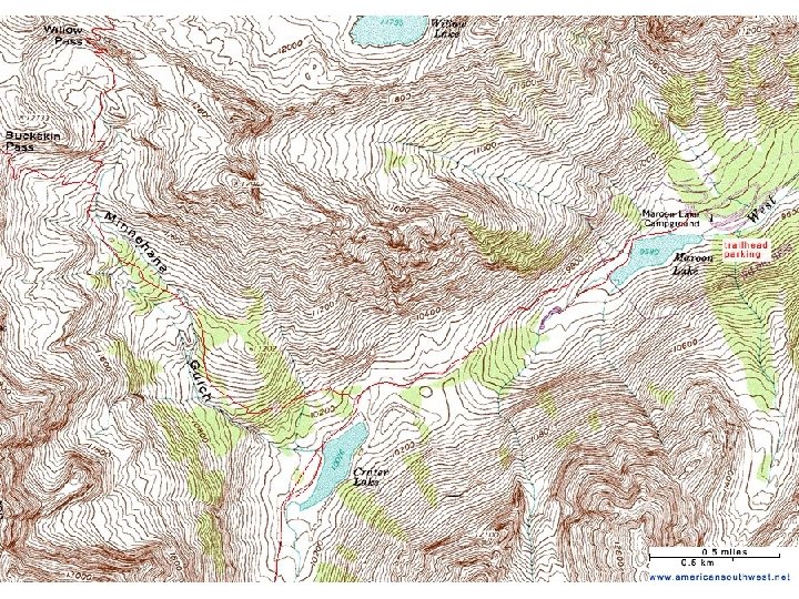
Unit 7 Lesson 4 Topographic Maps What are some ways to represent Earth’s surface? • A topographic map shows the shape of Earth’s surface with lines that represent different elevations. • Most lines on a topographic map are called contour lines, and they connect points of equal elevation. • Contour lines form closed loops, almost never cross, and are spaced depending on the land’s steepness. Copyright © Houghton Mifflin Harcourt Publishing Company
Unit 7 Lesson 4 Topographic Maps How do topographic maps show relief? • Relief is the difference between the highest and lowest elevations in a particular area. • A contour interval is the difference in elevation between two contour lines. • An index contour is a thicker contour line that often has an elevation label. Copyright © Houghton Mifflin Harcourt Publishing Company
Unit 7 Lesson 4 Topographic Maps How do topographic maps show locations of features? • Points, lines, and area symbols are used to represent features on topographic maps. • Points mark locations, such as mountain peaks and buildings. • Lines may represent features such as rivers, trails, roads, and boundaries. • Colored or textured areas are typically used to represent different types of land cover. Copyright © Houghton Mifflin Harcourt Publishing Company
Unit 7 Lesson 4 Topographic Maps How can you identify land features on topographic maps? • Certain patterns of contour lines can help you identify different types of land features. • Contour lines with a V shape may represent valleys or ridges. • Closed circles may represent hills or depressions. • Contour lines stacked very close together represent a steep land feature. Copyright © Houghton Mifflin Harcourt Publishing Company
Unit 7 Lesson 4 Topographic Maps How can you measure Earth’s surface using a topographic map? • A map scale shows the relationship between the sizes and distances shown on the map and the actual measurements on Earth’s surface. • Slope measures steepness from one point to another. • For slope in a topographic map, the rise is the change in elevation, and the run is the horizontal distance between two points. Copyright © Houghton Mifflin Harcourt Publishing Company
Unit 7 Lesson 3 Weathering, Erosion, and Deposition Copyright © Houghton Mifflin Harcourt Publishing Company
Unit 7 Lesson 3 Weathering, Erosion, and Deposition Crushers! What is weathering? • Weathering is this process by which rock breaks down into smaller pieces or changes composition. • Weathered rock pieces, known as sediment, are an important component of soil. • Differential weathering describes how different rocks in the same environment can weather at different rates. Copyright © Houghton Mifflin Harcourt Publishing Company
Unit 7 Lesson 3 Weathering, Erosion, and Deposition What is weathering? • Physical weathering is the breakdown of rock into smaller pieces. Physical weathering does not change the chemical makeup of a rock. • Chemical weathering changes the chemical makeup of a rock. • Physical weathering and chemical weathering often work together in nature. Copyright © Houghton Mifflin Harcourt Publishing Company
Unit 7 Lesson 3 Weathering, Erosion, and Deposition What causes physical weathering? • Abrasion is a process where agents, such as wind, water, and ice, carry particles that scrape against rock. • Plant roots can grow into the cracks of a rock and break the rock into pieces. Water accomplishes a similar feat by seeping into cracks, freezing, and expanding. • Digging animals can expose buried rocks to agents of physical weathering. Copyright © Houghton Mifflin Harcourt Publishing Company
Unit 7 Lesson 3 Weathering, Erosion, and Deposition What causes chemical weathering? • Two main agents that cause chemical weathering are oxygen and acids. • Oxidation occurs when certain chemicals in a rock react with oxygen to form new chemical compounds. • Acid precipitation can speed up chemical weathering. • Microscopic organisms, lichens, and mosses can also cause chemical weathering. Copyright © Houghton Mifflin Harcourt Publishing Company
Unit 7 Lesson 3 Weathering, Erosion, and Deposition Earth Movers What are erosion and deposition? • Erosion transports rock, sediment, and soil from one place to another. • Deposition lays down rock, sediment, and soil. • Erosion and deposition work together, constantly reshaping Earth’s surface. Copyright © Houghton Mifflin Harcourt Publishing Company
Unit 7 Lesson 3 Weathering, Erosion, and Deposition What causes erosion and deposition? • Wind, water, ice, and gravity are agents of both erosion and deposition. • Flowing water moves millions of tons of sediment every day. • A glacier is a large mass of ice that exists yearround and flows slowly over land. • Alpine glaciers can erode land to form jagged ridges and peaks. Continental glaciers can leave depressions in the land in which lakes form. Copyright © Houghton Mifflin Harcourt Publishing Company
Unit 7 Lesson 3 Weathering, Erosion, and Deposition What causes erosion and deposition? • Wind can move soil and sediment. Wind erosion and deposition creates sand dunes. • Gravity causes rocks and soil to move down a slope, a process known as mass movement. • Gravity also determines the movement of other agents of erosion, such as water and ice. Copyright © Houghton Mifflin Harcourt Publishing Company
Unit 7 Lesson 3 Weathering, Erosion, and Deposition Shore Shapers How can weathering and erosion shape coastal features? • Ocean waves and currents play a large role in shaping Earth’s shoreline. • Weathering and erosion along a shoreline can form sea cliffs, wave-cut platforms, sea caves, sea arches, and sea stacks. • Some parts of a shoreline may erode faster than others, leaving behind headlands. Copyright © Houghton Mifflin Harcourt Publishing Company
Unit 7 Lesson 3 Weathering, Erosion, and Deposition How can deposition shape coastal features? • Waves and currents deposit material to form features, and beaches are the main features of coastal deposition. • Longshore currents can deposit materials offshore to create features such as sand spits, tombolos, and barrier islands. Copyright © Houghton Mifflin Harcourt Publishing Company
Unit 7 Lesson 3 Weathering, Erosion, and Deposition Drip, Drop How can flowing water shape land? • Weathering and erosion by flowing water form various land features, such as valleys, cliffs, and canyons. • Acids in groundwater can slowly dissolve rock to form caves. Copyright © Houghton Mifflin Harcourt Publishing Company
Unit 7 Lesson 3 Weathering, Erosion, and Deposition How can flowing water shape land? • Deposition by flowing water forms features such as alluvial fans, deltas, and floodplains. • Cycles of flooding cause layers to build up along rivers, forming a flat floodplain. • Groundwater can deposit dissolved minerals in new locations to form stalactites and stalagmites. Copyright © Houghton Mifflin Harcourt Publishing Company
Unit 7 Lesson 3 Weathering, Erosion, and Deposition Ice Sculptures How can glaciers weather and erode Earth’s surface? • As glaciers move, they pick up material and scrape out the land beneath them. • Several land features characteristic of glacial weathering and erosion are cirques, glacial horns, and arêtes. Copyright © Houghton Mifflin Harcourt Publishing Company
Unit 7 Lesson 3 Weathering, Erosion, and Deposition What can melting glaciers deposit? • Glaciers also shape Earth’s surface by leaving behind lakes and deposits of rock and sediment. • Glacial deposition can create land features, such as glacial till, moraines, drumlins, erratics, and kettle lakes. Copyright © Houghton Mifflin Harcourt Publishing Company