Unit 6 Meteorology Review Regents Earth Science Miss


- Slides: 81

Unit 6 – Meteorology Review Regents Earth Science Miss Wojdan

1. Describe the relationship between temperature and altitude. A. As altitude increases, temperature increases B. As altitude increases, temperature decreases C. As altitude increases, temperature stays the same D. As altitude increases, temperature fluctuates

1. Describe the relationship between temperature and altitude. A. As altitude increases, temperature increases B. As altitude increases, temperature decreases C. As altitude increases, temperature stays the same D. As altitude increases, temperature fluctuates

2. Describe the relationship of pressure and altitude. A. As altitude increases, pressure increases B. As altitude increases, pressure decreases C. As altitude increases, pressure stays the same D. As altitude increases, pressure fluctuates

2. Describe the relationship of pressure and altitude. A. As altitude increases, pressure increases B. As altitude increases, pressure decreases C. As altitude increases, pressure stays the same D. As altitude increases, pressure fluctuates

3. In which layer of the atmosphere is ozone contained? A. B. C. D. Thermosphere Mesosphere Stratosphere Troposphere

3. In which layer of the atmosphere is ozone contained? A. B. C. D. Thermosphere Mesosphere Stratosphere Troposphere

4. How does temperature change in the mesosphere? A. B. C. D. Temperature decreases with height Temperature increases with height Temperature stays the same Temperature increases, then decreases

4. How does temperature change in the mesosphere? A. B. C. D. Temperature decreases with height Temperature increases with height Temperature stays the same Temperature increases, then decreases

5. Which location will generally have the most annual precipitation? A. B. C. D. A B C D

5. Which location will generally have the most annual precipitation? A. B. C. D. A B C D

6. Jet streams generally move across the United States from the: A. B. C. D. North to South to North West to East to West

6. Jet streams generally move across the United States from the: A. B. C. D. North to South to North West to East to West

7. What instrument is used to measure barometric pressure? A. B. C. D. Barometer Thermometer Sling Psychrometer Wind Vane

7. What instrument is used to measure barometric pressure? A. B. C. D. Barometer Thermometer Sling Psychrometer Wind Vane

8. Which instrument is used to measure relative humidity? A. B. C. D. Thermometer Anemometer Sling Psychrometer Barometer

8. Which instrument is used to measure relative humidity? A. B. C. D. Thermometer Anemometer Sling Psychrometer Barometer

9. Which atmospheric conditions describe the air mass that is influencing weather conditions at location C? A. B. C. D. Cool and Dry Cool and Moist Warm and Dry Warm and Moist

9. Which atmospheric conditions describe the air mass that is influencing weather conditions at location C? A. B. C. D. Cool and Dry Cool and Moist Warm and Dry Warm and Moist

10. Which ocean current warms the climate of northwestern Europe? A. B. C. D. North Atlantic Current Canary Current North Equatorial Current Labrador Current

10. Which ocean current warms the climate of northwestern Europe? A. B. C. D. North Atlantic Current Canary Current North Equatorial Current Labrador Current

11. Which New York State weather station had clear skies? A. B. C. D. Albany Buffalo New York City Syracuse

11. Which New York State weather station had clear skies? A. B. C. D. Albany Buffalo New York City Syracuse

12. Which symbol would be used to represent this front on a weather map? A. B. C. D.

12. Which symbol would be used to represent this front on a weather map? A. B. C. D.

13. What controls the direction of movement of most surface ocean currents? A. Density differences at varying ocean depths B. Varying salt content of the oceans C. Prevailing winds D. Seismic activity

13. What controls the direction of movement of most surface ocean currents? A. Density differences at varying ocean depths B. Varying salt content of the oceans C. Prevailing winds D. Seismic activity

14. Which symbol correctly represents the frontal boundary at line AB? A. B. C. D.

14. Which symbol correctly represents the frontal boundary at line AB? A. B. C. D.

15. Which air mass is associated with low relative humidity and low air temperature? A. B. C. D. Continental Polar Continental Tropical Maritime Polar Maritime Tropical

15. Which air mass is associated with low relative humidity and low air temperature? A. B. C. D. Continental Polar Continental Tropical Maritime Polar Maritime Tropical

16. What is the dewpoint when the air temperature is 26°C and the relative humidity is 77%? A. 3⁰C B. 20⁰C C. 22⁰C D. 23⁰C

16. What is the dewpoint when the air temperature is 26°C and the relative humidity is 77%? A. 3⁰C B. 20⁰C C. 22⁰C D. 23⁰C

17. Based on these readings, the relative humidity of the air is closest to A. B. C. D. 8% 11% 32% 60%

17. Based on these readings, the relative humidity of the air is closest to A. B. C. D. 8% 11% 32% 60%

18. The climate of which location is warmed by a nearby major ocean current? A. B. C. D. A B C D

18. The climate of which location is warmed by a nearby major ocean current? A. B. C. D. A B C D

19. Which weather variable would most likely decrease ahead of an approaching storm system? A. B. C. D. Wind Speed Air Pressure Cloud Cover Relative Humidity

19. Which weather variable would most likely decrease ahead of an approaching storm system? A. B. C. D. Wind Speed Air Pressure Cloud Cover Relative Humidity

20. Which graph best represents the change in air pressure as air temperature increases at Earth’s surface? A. B. C. D.

20. Which graph best represents the change in air pressure as air temperature increases at Earth’s surface? A. B. C. D.

21. What is the dewpoint if the relative humidity is 100% and the air temperature is 20°C? A. B. C. D. 0⁰C 10⁰C 20⁰C 100⁰C

21. What is the dewpoint if the relative humidity is 100% and the air temperature is 20°C? A. B. C. D. 0⁰C 10⁰C 20⁰C 100⁰C

22. Which station model correctly shows wind coming from the west at 25 -knots? A. B. C. D.

22. Which station model correctly shows wind coming from the west at 25 -knots? A. B. C. D.

23. The circulation of surface winds associated with a low-pressure system is: A. Counterclockwise and toward the center B. Counterclockwise and away from the center C. Clockwise and toward the center D. Clockwise and away from the center

23. The circulation of surface winds associated with a low-pressure system is: A. Counterclockwise and toward the center B. Counterclockwise and away from the center C. Clockwise and toward the center D. Clockwise and away from the center

24. Which sequence of ocean currents was responsible for the movement of these boats? A. South Equatorial → Gulf Stream → Labrador → Benguela B. South Equatorial → East Australia → Antarctic Circumpolar → Peru C. North Equatorial → Koroshio → North Pacific → California D. North Equatorial → Gulf Stream → North Atlantic → Canary

24. Which sequence of ocean currents was responsible for the movement of these boats? A. South Equatorial → Gulf Stream → Labrador → Benguela B. South Equatorial → East Australia → Antarctic Circumpolar → Peru C. North Equatorial → Koroshio → North Pacific → California D. North Equatorial → Gulf Stream → North Atlantic → Canary

25. What is the dewpoint temperature when the relative humidity is 30% and the air temperature is 20°C? A. B. C. D. -28⁰C 2⁰C 6⁰C 9⁰C

25. What is the dewpoint temperature when the relative humidity is 30% and the air temperature is 20°C? A. B. C. D. -28⁰C 2⁰C 6⁰C 9⁰C

26. Which weather variable is measured by this instrument? A. B. C. D. Wind Direction Air Pressure Wind Speed Relative Humidity

26. Which weather variable is measured by this instrument? A. B. C. D. Wind Direction Air Pressure Wind Speed Relative Humidity

27. On which station model would the present weather symbol * most likely be found? A. B. C. D.

27. On which station model would the present weather symbol * most likely be found? A. B. C. D.

28. A barometric pressure of 1021. 0 millibars is equal to how many inches of mercury? A. 29. 88 in. Hg B. 30. 15 in. Hg C. 30. 25 in. Hg D. 30. 50 in. Hg

28. A barometric pressure of 1021. 0 millibars is equal to how many inches of mercury? A. 29. 88 in. Hg B. 30. 15 in. Hg C. 30. 25 in. Hg D. 30. 50 in. Hg

29. The planetary wind belts in the troposphere are primarily caused by the A. Earth’s rotation and the uneven distribution of heat on the surface B. Earth’s revolution and the uneven distribution of heat on the surface C. Earth’s rotation and the Sun’s gravitational force on the Earth’s surface D. Earth’s revolution and the Sun’s gravitational force on the Earth’s surface

29. The planetary wind belts in the troposphere are primarily caused by the A. Earth’s rotation and the uneven distribution of heat on the surface B. Earth’s revolution and the uneven distribution of heat on the surface C. Earth’s rotation and the Sun’s gravitational force on the Earth’s surface D. Earth’s revolution and the Sun’s gravitational force on the Earth’s surface

30. Which map best shows the most probable areas of precipitation associated with these weather systems? A. B. C. D.

30. Which map best shows the most probable areas of precipitation associated with these weather systems? A. B. C. D.

31. Which station model correctly represents the weather conditions in an area that is experiencing winds from the northeast at 25 knots and has had a steady drop in barometric pressure of 2. 7 millibars during the last three hours? A. B. C. D.

31. Which station model correctly represents the weather conditions in an area that is experiencing winds from the northeast at 25 knots and has had a steady drop in barometric pressure of 2. 7 millibars during the last three hours? A. B. C. D.

32. Air masses are identified on the basis of temperature and A. B. C. D. Type of precipitation Wind Velocity Atmospheric Transparency Moisture Content

32. Air masses are identified on the basis of temperature and A. B. C. D. Type of precipitation Wind Velocity Atmospheric Transparency Moisture Content

33. Which New York State location is most likely to experience the heaviest winter snowfall when the surface winds are blowing from the west or northwest? A. B. C. D. New York City Binghamton Oswego Plattsburgh

33. Which New York State location is most likely to experience the heaviest winter snowfall when the surface winds are blowing from the west or northwest? A. B. C. D. New York City Binghamton Oswego Plattsburgh

34. The upward movement of air in the atmosphere generally causes the temperature of that air to A. Decrease and become closer to the dewpoint B. Decrease and become farther from the dewpoint C. Increase and become closer to the dewpoint D. Increase and become farther from the dewpoint

34. The upward movement of air in the atmosphere generally causes the temperature of that air to A. Decrease and become closer to the dewpoint B. Decrease and become farther from the dewpoint C. Increase and become closer to the dewpoint D. Increase and become farther from the dewpoint

35. What is the barometric pressure indicated by this station model? A. B. C. D. 0. 029 mb 902. 9 mb 1029. 0 mb

35. What is the barometric pressure indicated by this station model? A. B. C. D. 0. 029 mb 902. 9 mb 1029. 0 mb

36. What is the relative humidity when the dry-bulb temperature is 16°C and the wetbulb temperature is 14°C? A. B. C. D. 90% 80% 14% 13%

36. What is the relative humidity when the dry-bulb temperature is 16°C and the wetbulb temperature is 14°C? A. B. C. D. 90% 80% 14% 13%

37. Which ocean current brings warm water to the western coast of Africa? A. B. C. D. Agulhas Current North Equatorial Current Canary Current Guinea Current

37. Which ocean current brings warm water to the western coast of Africa? A. B. C. D. Agulhas Current North Equatorial Current Canary Current Guinea Current

38. Clouds usually form on the windward sides of mountains because this is where air A. B. C. D. Rises and cools Rises and warms Sinks and cools Sinks and warms

38. Clouds usually form on the windward sides of mountains because this is where air A. B. C. D. Rises and cools Rises and warms Sinks and cools Sinks and warms

39. In the United States, most tornadoes are classified as intense A. Low-pressure funnel clouds that spin clockwise B. Low-pressure funnel clouds that spin counterclockwise C. High-pressure funnel clouds that spin clockwise D. High-pressure funnel clouds that spin counterclockwise

39. In the United States, most tornadoes are classified as intense A. Low-pressure funnel clouds that spin clockwise B. Low-pressure funnel clouds that spin counterclockwise C. High-pressure funnel clouds that spin clockwise D. High-pressure funnel clouds that spin counterclockwise

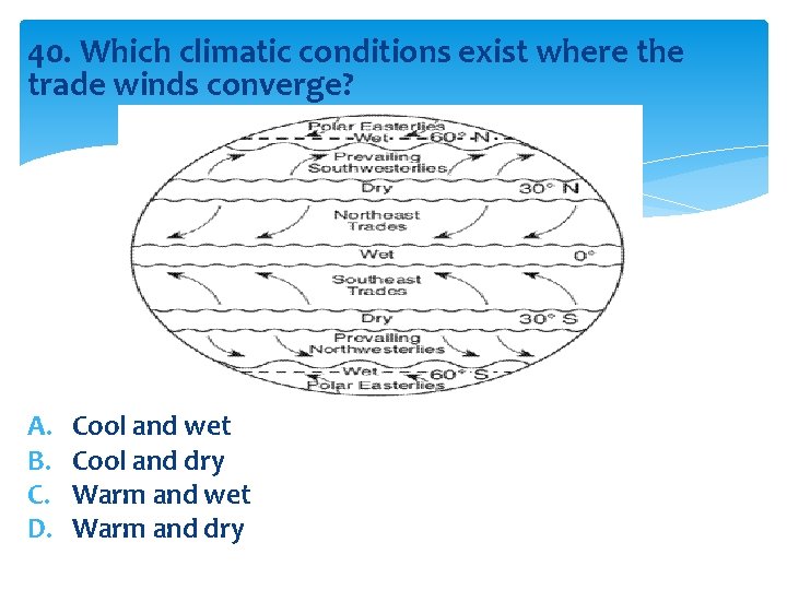
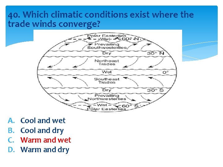
40. Which climatic conditions exist where the trade winds converge? A. B. C. D. Cool and wet Cool and dry Warm and wet Warm and dry

40. Which climatic conditions exist where the trade winds converge? A. B. C. D. Cool and wet Cool and dry Warm and wet Warm and dry