Unit 3 The Hydrosphere Where does our water


 • Water at")


 comes from.")


- Slides: 29
Unit 3 The Hydrosphere
Where does our water come from? ? • 71% of the Earth’s surface is covered with water • 97% of water is in the oceans • 3% is freshwater • 2 % is in glaciers and ice • 0. 4% is in rivers, streams, lakes, and the atmosphere • 0. 6% is in groundwater (and available for human consumption)
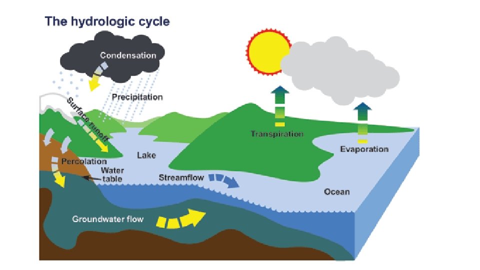
Hydrologic Cycle • Evaporation • Liquid changing to a gas (vapor) • Water at the surface of lakes, rivers, oceans, etc. evaporates due to energy from the sun.
Hydrologic Cycle • Transpiration • Water evaporating from plants. • Plants lose water through their leaves, stems, and roots.
Hydrologic Cycle • Condensation • When water vapor changes into a liquid form. • Water vapor rises in the air and cools and small water droplets are formed – this creates clouds.
Hydrologic Cycle • Precipitation • When water is released from a cloud in the form of rain, snow, sleet, freezing rain, etc. • Precipitation is the primary water enters the atmosphere.
Hydrologic Cycle • Infiltration • The process by which water gets absorbed into the ground
Hydrologic Cycle • Runoff • Water that doesn’t get absorbed by the ground or evaporated becomes runoff.
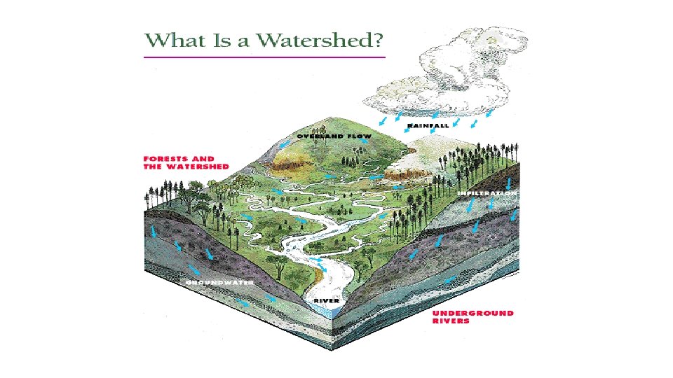
Watersheds ● ● ● Land area that contributes to a stream, lake, or other body of water Imaginary Line called a divide separates a drainage basin Divides usually along ridges
River Basins • River basin – portion of land drained by a river and its tributaries • Tributary – a river/stream flowing into a larger river or lake
What is the difference between a river basin and a watershed? • Both river basins and watersheds areas of land that drain to a particular body of water (lake, stream, river, estuary) • River basins … all water drains to a large river • Watershed … a smaller area of land that drains to a smaller stream, lake, or wetland • There are many smaller watersheds within a river basin.
Groundwater • Groundwater is where our potable water (safe for human consumption) comes from.
Groundwater • The importance of groundwater • Consumption • Recharge/discharge of lakes and rivers • Pollution/Contaminates • Slope Stability and Subsidence
Porosity • Porosity is the amount of pore space in a rock, or the open spaces between the grains. • a. High porosity – beach sand • b. Low porosity – well-cemented sandstone
Permeability • Permeability is the ease with which the fluids flow through a rock or sediment.
Porosity and Permeability • Permeability depends on: i. Porosity – the higher the porosity the higher the permeability. ii. Larger Sediments are more permeable than finer grained sediments because the pores between the grains are larger. iii. Sorting or arranging of pores. iv. Connectivity of grains. v. Packing. (Controls pore size)
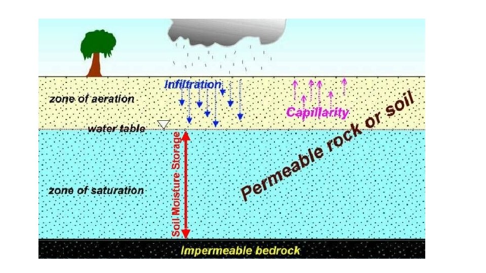
The Water Table • Infiltration – when it rains, some of the water percolates, or soaks, into the ground. • Some of the water is held in the soil because it clings to the soil particles • Some may evaporate from the soil • Zone of aeration – may be used by plants
Water Table • Excess water penetrates downward until it reaches the water table. • zone of saturation – below the water table, all of the pore spaces are filled with water. • The water table is the top of the zone of saturation.
Water Table • The water table is not flat. It mimics the topography. It stands somewhat higher under hills, and lower under valleys.
Water Table • Springs, lakes, swamps, or rivers are present where the water table intersects (or lies above) the ground surface • If a well is drilled, the water level in the well is at the water table.
Water Table • Think about when you went to the seashore and dug a hole in the sand near the sea. What happened?
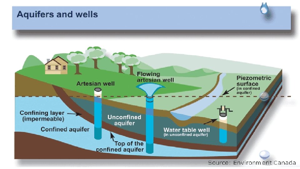
Aquifers 1. An aquifer is a water-bearing rock. 1. Aquifers have high porosity and high permeability.
Wells How much water can a well yield? An average figure is about 5 gallons per minute.
Artesian Well A deep well that passes through impermeable rock and reaches water that is held under pressure between the impermeable rock layers