Unit 1 Unit 1 Syllabus Introduction Frequency Allocations

Unit 1

Unit 1 Syllabus Introduction Frequency Allocations for Satellite Services Intelsat – U. S. Domsats – Polar Orbiting Satellites Definitions of Terms for Earth-orbiting Satellites Kepler’s First Law – Kepler’s Second Law – Kepler’s Third. Law Orbital Elements – Apogee and. Perigee Heights Orbital Perturbations – Effects of a Calendars – Universal Time – Julian Dates Nonspherical Earth – Atmospheric Drag – – Sidereal Time Inclined Orbits Earth Station Referred to the IJK Frame – The Orbital Plane– The Geocentric. The. Top centric-Horizon Co-ordinate Equatorial Coordinate System The Sub-satellite Point – Predicting Problems Satellite Position.

History • Communicating through a satellite first appeared in the short story titled “The Brick Moon, ” written by an American author Edward Everett Hale and published in The Atlantic Monthly in 1869– 70. • The first practical concept of satellite communication was proposed by 27 -year-old Royal Air Force officer Arthur C. Clarke in a paper titled “Extra. Terrestrial Relays: Can Rocket Stations Give Worldwide Radio Coverage? ” published in the October 1945 issue of Wireless World.

The first artificial Satellite • Sputnik 1, was launched successfully by the Soviet Union on October 4, 1957. • It was only 58 cm (23 inches) in diameter with four antennas sending low-frequency radio signals at regular intervals. • It orbited Earth in a elliptical orbit, • Took 96. 2 minutes to complete one revolution. • It transmitted signals for only 22 days until its battery ran out • Was in orbit for only three months

Sputnik 1

First satellite to relay voice signals • Launched by the U. S. government’s Project SCORE (Signal Communication by Orbiting Relay Equipment) from Cape Canaveral, Florida, on December 19, 1958. • It broadcast a taped message conveying “peace on earth and goodwill toward men everywhere” from U. S. Pres. Dwight D. Eisenhower.

Score at launch pad
")
KEY TECHNOLOGIST • American engineers John Pierce of American Telephone and Telegraph Company’s (AT&T’s) Bell Laboratories and Harold Rosen of Hughes Aircraft Company developed key technologies in the 1950 s and ’ 60 s that made commercial communication satellites possible. • Pierce outlined the principles of satellite communications in an article titled “Orbital Radio Relays” published in the April 1955 issue of Jet Propulsion. • In it he calculated the precise power requirements to transmit signals to satellites in various Earth orbits. • Pierce’s main contribution to satellite technology was the development of the traveling wave tube amplifier, which enabled a satellite to receive, amplify, and transmit radio signals. • Rosen developed spin-stabilization technology that provided stability to satellites orbiting in space.

NASA -National Aeronautics and Space Administration

ECHO 1 • Established in 1958 • It embarked on a program to develop satellite technology. • NASA’s first project was the Echo 1 satellite that was developed in coordination with AT&T ’s Bell Labs. • Pierce led a team at Bell Labs that developed the Echo 1 satellite, which was launched on August 12, 1960. • Echo 1 was a 30. 5 -metre (100 -foot) aluminumcoated balloon that contained no instruments but was able to reflect signals from the ground. • Since Echo 1 only reflected signals, it was considered a passive satellite.

ECHO 1

ECHO 2 • Echo 2, managed by NASA’s Goddard Space Flight Center in Beltsville, Maryland, was launched on January 25, 1964. • NASA abandoned passive communications systems in favour of active satellites. • The Echo 1 and Echo 2 was proved to be indispensable later in the development of active satellite systems.

ECHO 2

TELSTAR • Pierce’s team also developed Telstar 1, the first active communications satellite capable of two-way communications. • Was launched into low Earth orbit on July 10, 1962, by a Delta rocket. • NASA provided the launch services and some tracking and telemetry support. • It was the first satellite to transmit live television images between Europe and North America. • It also transmitted the first phone call via satellite - a brief call from AT&T chairman Frederick Kappel transmitted from the ground station in Andover, Maine, to U. S. Pres. Lyndon Johnson in Washington, D. C.

Telestar 1

SYNCOM • Rosen’s team at Hughes Aircraft attempted to place the first satellite in geostationary orbit, Syncom 1, on February 14, 1963. • However, Syncom 1 was lost shortly after launch. • Syncom 1 was followed by the successful launch of Syncom 2, the first satellite in a geosynchronous orbit (an orbit that has a period of 24 hours but is inclined to the Equator), on July 26, 1963, • Syncom 3, the first satellite in geostationary orbit, on August 19, 1964. • Syncom 3 broadcast the 1964 Olympic Games from Tokyo, Japan, to the United States, the first major sporting event broadcast via satellite.

SYNCOM

Advantages of Satellite communication • Satellite links are unaffected by the propagation variations that interfere with HF radio. • Free from the high attenuation of wire or cable facilities • Capable of spanning long distances. • The numerous repeater stations required for lineof-sight or troposcatter links are no longer needed. • They furnish the reliability and flexibility of service that is needed to support a military operation.

Advantages of Satellite communication • The system is capable of handling thousands of communications channels. • Frequencies are not dependent upon reflection or refraction and are affected only slightly by atmospheric phenomena. • Destruction of a single communication satellite would be quite difficult and expensive. • A high degree of freedom from jamming

HOW?

Frequency Allocations for Satellite Services • International Telecommunication Union

ITU Regions • Region 1: Europe, Africa, what was formerly the Soviet Union, and Mongolia • Region 2: North and South America and Greenland • Region 3: Asia, Australia, and the southwest Pacific

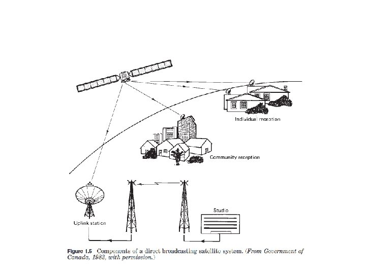
Services provided by satellites Name of the satellite Services Fixed satellite service • Telephone Networks • Transmitting TV signals to cable companies Broadcasting satellite service Direct Broad cast service or DTH Mobile satellite services • Land Mobile • Maritime mobile • Aeronautical Mobile Navigational satellite services GPS Meteorological satellite services Search and rescue services

Frequency Band Designations • • used for mobile and navigational services and for data transfer from weather satellites. used for mobile satellite services and navigation systems. used for FSS and no direct broadcast services are allowed (6/4 GHz) used at present for DBS, and it is also used for certain fixed satellite services. (14/12 GHz)

Overview of satellite systems 1. The largest international system, Intelsat, 2. The domestic satellite system in the United States, Domsat, and 3. U. S. National Oceanographic and Atmospheric Administration (NOAA) series of polar orbiting satellites used for environmental monitoring and search and rescue.

INTELSAT

INTELSAT International Telecommunication Satellite Created in 1964 Has 140 member countries 40 investing entities satellites are in geostationary orbit, geostationary satellites orbit in the earth’s equatorial plane and that their position is specified by their longitude. • Life time is 10 to 15 years • • •
, • the Indian")
INTELSAT covers three main regions, the • Atlantic Ocean Region (AOR), • the Indian Ocean Region (IOR), and • the Pacific Ocean Region (POR). • Traffic in the AOR is about three times that in the IOR and about twice that in the IOR and POR combined. • Thus the system design is tailored mainly around AOR requirements (Thompson and Johnston, 1983)

INTELSAT

Evolution of some of the INTELSAT satellites.

Intel sat VII capacity Parameters Two way telephone circuits TV channels Two way telephone circuits achieved with digital circuit multiplication VII 1800 3 90000 Life time is for 14 to 17 years Intel sat IX is for self study VII/A 22500 3 112500

U. S Domsat – Domestic satellite • Used to provide various telecommunications services, such as: • voice, data & video transmissions, within a country. • Situated in geostationary orbit. • Wide selection of TV channels for the home entertainment market • A large amount of commercial telecommunications traffic is also handeled

Domsat • Provides a DTH television service • Can be classified broadly as – high power, – medium power, and – low power • the primary purpose of satellites in the high-power category is to provide a DBS service. • In the medium-power category, the primary purpose is point-to-point services, but space may be leased on these satellites for the provision of DBS services. • In the low-power category, no official DBS services are provided.
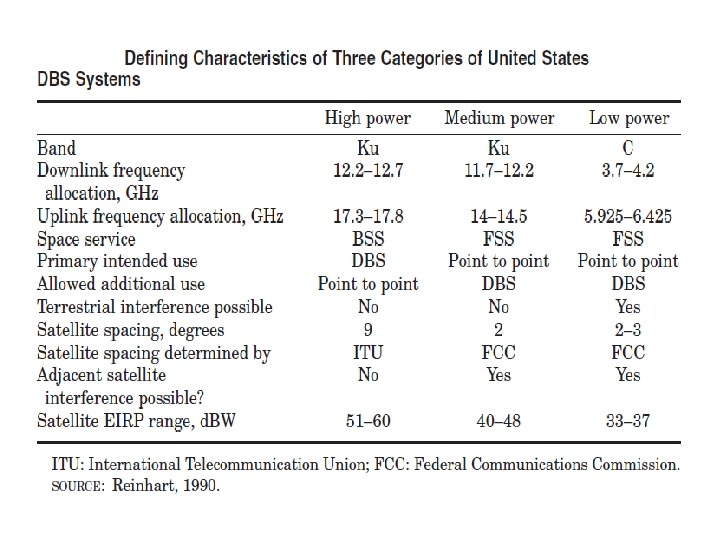

Minimum Orbital Spacing - DOMSAT • In 1983, the U. S. Federal Communications Commission (FCC) adopted a policy objective. • 2° as the minimum orbital spacing for satellites operating in the 6/4 -GHz band • 1. 5° for those operating in the 14/12 -GHz band (FCC, 1983). • It is clear that interference between satellite circuits is likely to increase as satellites are positioned closer together.

Polar Orbiting Satellites • Orbit the earth to cover the north and south polar regions.

The polar orbiters • Able to track weather conditions and provide a wide range of data, – Includes visible and infrared radiometer data for imaging purposes – radiation measurements, and – temperature profiles. • They carry ultraviolet sensors that measure ozone levels, • They monitor the ozone hole over Antarctica.

Kepler’s three Law 1. The orbit of a planet is an ellipse with the Sun at one of the two foci. 2. A line segment joining a planet and the Sun sweeps out equal areas during equal intervals of time. 3. The square of the orbital period of a planet is proportional to the cube of the semi-major axis of its orbit.

Kepler’s First Law • States that the path followed by a satellite around the primary will be an ellipse.

Eccentricity • The eccentricity is defined as • For a circle, e = 0 – The range of values of the eccentricity for ellipses is 0 < e < 1 – The higher the value of e, the longer and thinner the ellipse

Kepler’s second law • States that, for equal time intervals, a satellite will sweep out equal areas in its orbital plane, focused at the barycenter.

Kepler’s Third Law •

Kepler’s Third Law

Example • Average orbital radius – Earth = 1. 5 X 10⁸ m – Jupiter = 7. 8 X 10⁸ m • Orbital period – Earth = 1. 0 years – Jupiter = ? ? – Ans = 11. 9 Years

Definitions of Terms for Earth-Orbiting Satellites

Inclination The angle between the orbital plane and the earth’s equatorial plane. It is measured at the ascending node from the equator to the orbit, going from east to north. Apogee The point farthest from earth. Perigee The point of closest approach to earth. Line of apsides : The line joining the perigee and apogee through the center of the earth.

Descending node The point where the orbit crosses the equatorial plane going from north to south. Ascending node The point where the orbit crosses the equatorial plane going from south to north. Line of nodes The line joining the ascending and descending nodes through the center of the earth.

• Prograde orbit: An orbit in which the satellite moves in the same direction as the earth’s rotation. • It is also known as a direct orbit. • The inclination of the orbit always lies between 0 and 90°. • Most satellites are launched in this orbit. • Because the earth’s rotational velocity provides part of the orbital velocity with a consequent saving in launch energy.

Retrograde orbit An orbit in which the satellite moves in a direction counter to the earth’s rotation, The inclination of a retrograde orbit always lies between 90 and 180°.

Argument of perigee The angle from ascending node to perigee, measured in the orbital plane at the earth’s center, in the direction of satellite motion.

Right ascension of the ascending node : For an absolute measurement of an orbit , a fixed reference in space is required. The reference chosen is the first point of Aries, otherwise known as the vernal, or spring, equinox. It occurs when the sun crosses the equator going from south to north, An imaginary line is drawn from this equatorial crossing through the center of the sun points to the first point of Aries (symbol ). This is the line of Aries. The right ascension of the ascending node is then the angle measured eastward, in the equatorial plane, from the line to the ascending node.

Mean Anomaly • Mean anomaly “M” gives an average value of the angular position of the satellite with reference to the perigee. • For a circular orbit, M gives the angular position of the satellite in the orbit. • For elliptical orbit, the position is much more difficult to calculate, and M is used as an intermediate step in the calculation.

True anomaly • The true anomaly is the angle from perigee to the satellite position, measured at the earth’s center. • This gives the true angular position of the satellite in the orbit as a function of time.

Keplers 3 rd Law Brief • Kepler’s third law can be written in the form • where n is the mean motion of the satellite in radians per second and • μ is the earth’s geocentric gravitational constant. • With a in meters, its value is • With n in radians per second, the orbital period in seconds is given by,

ORBITAL ELEMENTS Definition • A set of mathematical parameters that enables us to accurately describe satellite motion

ORBITAL ELEMENTS Purpose • Discriminate one satellite from other satellites • Predict where a satellite will be in the future or has been in the past • Determine amount and direction of maneuver or perturbation
 ü Inclination ü")
The Six Keplerian Elements ü Size/Period ü Shape (Circular or Ellipse) ü Inclination ü Right Ascension ü Argument of Perigee ü True Anomaly

Size/Period • Size is how big or small your satellite’s orbit is…. • Defined by semi-major axis “a” • There are basically 4 sizes of orbits satellites use: – Low Earth Orbit (LEO): approx 120 – 1200 miles above Earth – Medium Earth Orbit (MEO) or Semi-synchronous Orbit: approx 12, 000 miles above Earth – Highly Elliptical Orbit (HEO): altitude varies greatly! From 100 miles to sometimes several hundred thousand miles – Geo-synchronous or Geo-stationary Orbit (GEO): approx 22, 300 miles from Earth
 or Retrograde (towards the")
Location of Orbits • Equatorial – Prograde (towards the east) or Retrograde (towards the west) • Polar – Over the Poles!! • A very Important Point: ALL ORBITS OF SATELLITES MUST INTERSECT THE CENTER OF THE EARTH

Shape • Orbit shapes are either circular or not circular: some sort of an. Ellipse!! • How elliptical an orbit, is called Eccentricity

Circular Orbits • Characteristics – – Constant speed Nearly constant altitude • Typical Missions – – Reconnaissance/Weather (DMSP) Manned Navigational (GPS) Geo-synchronous (Comm sats)

Elliptical Orbits • Characteristics – – – Varying speed Varying altitude Asymmetric Ground Track • Typical Missions – – – Deep space surveillance (Pioneer) Communications (Polar comm. ) Ballistic Missiles

Eccentricity “e” e = 0. 75 e =. 45 e=0

Inclination “i” • Inclination is the tilt of your orbit • At 0 degrees of inclination, you are orbiting the equator • At 90 degrees of inclination, you are in a polar orbit Equatorial Plane Inclination: Is this angle, measured in degrees Inclination Orbital Plane

Inclination “i” Prograde: 0 i < 90 Equatorial: i = 0 or 180 Polar: i = 90 Retrograde: 90 i < 180

Right Ascension “Ω” • Right Ascension is the swivel of your tilt, as measured from a fixed point in space, called the First Point of Aries ii e Lin of s de No First Point of Aries ( ) Right Ascension of the Ascending Node ( )

Right Ascension “Ω” • Right Ascension will determine where your satellite will cross the Equator on the ascending pass • It is measured in degrees Inclination Lin es od f. N eo First Point of Aries ( ) Right Ascension is this angle, measured in degrees

Argument of Perigee “ω” • Argument of Perigee is a measurement from a fixed point in space to where perigee occurs in the orbit • It is measured in degrees Perigee Inclination Lin es od f. N eo Apogee Argument of Perigee: Is this angle, measured in degrees

True Anomaly • True Anomaly is a measurement from a fixed point in space to the actual satellite location in the orbit • It is measured in degrees True Anomaly: Is this angle, measured in degrees Direction of satellite motion Fixed point in space

Summery of Keplerian elements • Earth-orbiting artificial satellites are defined by six orbital elements referred to as the Keplerian element set. – the semimajor axis a – the eccentricity e – the mean anomaly M 0, gives the position of the satellite in its orbit at a reference time known as the epoch. – The argument of perigee ω, gives the rotation of the orbit’s perigee point relative to the orbit’s line of nodes in the earth’s equatorial plane. – the inclination i and – the right ascension of the ascending node Ω , relate the orbital plane’s position to the earth.

Apogee and Perigee Heights • the length of the radius vectors at apogee and perigee can be obtained from the geometry of the ellipse • In order to find the apogee and perigee heights, the radius of the earth must be subtracted from the radii lengths,

Orbit Perturbations • Effects of a nonspherical earth • For a spherical earth of uniform mass, Kepler’s third law gives the nominal mean motion n 0 as • The 0 subscript is included as a reminder that this result applies for a perfectly spherical earth of uniform mass.

Effects of a nonspherical earth • However not practically – K 1 is a constant which evaluates to 66, 063. 1704 km 2. • The earth’s oblateness has negligible effect on the semi major axis a, • If a is known, the mean motion is readily calculated. • The orbital period taking into account the earth’s oblateness is termed the anomalistic period

Effects of a nonspherical earth • The anomalistic period is • where n is in radians per second. • If the known quantity is n one can solve the above Eq. for a, keeping in mind that n 0 is also a function of a. • The above equation may be solved for a by finding the root of the following equation:

Problem • A satellite is orbiting in the equatorial plane with a period from perigee to perigee of 12 h. Given that the eccentricity is 0. 002, calculate the semimajor axis. The earth’s equatorial radius is 6378. 1414 km.

Answer • Non perturbed value a = 26597 km • Perturbed Value a = 26598. 6 km

Effects of a nonspherical earth • The oblateness of the earth also produces two rotations of the orbital plane. • regression of the nodes, – where the nodes appear to slide along the equator. – In effect, the line of nodes, which is in the equatorial plane, rotates about the center of the earth. – Thus , the right ascension of the ascending node, shifts its position.

Effects of a nonspherical earth • If the orbit is prograde the nodes slide westward, • if retrograde, they slide eastward. • As seen from the ascending node, a satellite in prograde orbit moves eastward, and in a retrograde orbit, westward. • The nodes therefore move in a direction opposite to the direction of satellite motion, hence the term regression of the nodes. • For a polar orbit (i = 90°), the regression is zero.

Effects of a nonspherical earth • The second effect is rotation of apsides in the orbital plane, • Both effects depend on the mean motion n, the semimajor axis a, and the eccentricity e

Atmospheric Drag • For satellites below 1000 km, the effects of atmospheric drag are significant. • Because the drag is greatest at the perigee, • The drag acts to reduce the velocity at this point, resulting the satellite not toreach the same apogee height on successive revolutions. • As a result the semi major axis and the eccentricity are both reduced. • Drag does noticeably change the other orbital parameters, including perigee height.

Atmospheric Drag • An approximate expression for the change of major axis is • The mean anomaly is also changed. • An approximate expression for the amount by which it changes is

Inclined Orbits • Determination of the look angles and range involves the following quantities and concepts: 1. The orbital elements, 2. Various measures of time 3. The perifocal coordinate system, which is based on the orbital plane 4. The geocentric-equatorial coordinate system, which is based on the earth’s equatorial plane 5. The topocentric-horizon coordinate system, which is based on the observer’s horizon plane

Inclined Orbits • The two major coordinate transformations which are needed are as follows: ■ The satellite position measured in the perifocal system is transformed – to the geocentric-horizon system in which the earth’s rotation is measured, thus enabling the satellite position and the earth station location to be coordinated. ■ The satellite-to-earth station position vector is transformed – to the topocentric-horizon system, which enables the look angles and range to be calculated.
- Slides: 84