
Unit 1 Test Review Which map would be

Unit 1 Test Review
Which map would be a large scale map? 1. 2. 3. 4. 5. country continent state city world
Which map would be a large scale map? 1. 2. 3. 4. 5. country continent state city world
A place’s location relative to other objects or places is called its 1. 2. 3. 4. 5. Absolute location Region Site Relative location Dimension
A place’s location relative to other objects or places is called its 1. 2. 3. 4. 5. Absolute location Region Site Relative location Dimension
An object at 90 degrees north latitude is 1. 2. 3. 4. 5. At the North Pole On the equator At the Tropic of Cancer At the Tropic of Capricorn Closer to Australia than to Europe
An object at 90 degrees north latitude is 1. 2. 3. 4. 5. At the North Pole On the equator At the Tropic of Cancer At the Tropic of Capricorn Closer to Australia than to Europe
The International Date Line is approximately ___ degrees from the Prime Meridian. 1. 2. 3. 4. 5. 0 45 90 180 360
The International Date Line is approximately ___ degrees from the Prime Meridian. 1. 2. 3. 4. 5. 0 45 90 180 360
An area with one or more unique and distinguishing characteristics is called a: 1. 2. 3. 4. 5. Locality Situation Site Location Region
An area with one or more unique and distinguishing characteristics is called a: 1. 2. 3. 4. 5. Locality Situation Site Location Region

The movement of money from one country to another and one currency to another has primarily been facilitated by 1. The leadership of the United States 2. Advances in electronic communications 3. The World Trade Organization 4. Transnational corporations 5. Global agreements brokered by the United Nations

The movement of money from one country to another and one currency to another has primarily been facilitated by 1. The leadership of the United States 2. Advances in electronic communications 3. The World Trade Organization 4. Transnational corporations 5. Global agreements brokered by the United Nations
Globalization 1. Decreases consumer preferences 2. Promotes the maintenance of traditional cultures 3. Benefits some countries more than others 4. Decreases communication across borders 5. Is tightly controlled by the United States
Globalization 1. Decreases consumer preferences 2. Promotes the maintenance of traditional cultures 3. Benefits some countries more than others 4. Decreases communication across borders 5. Is tightly controlled by the United States
The frequency an object appears in a given area is its 1. 2. 3. 4. 5. Distribution Density Relative location Dispersion Diffusion
The frequency an object appears in a given area is its 1. 2. 3. 4. 5. Distribution Density Relative location Dispersion Diffusion
That the physical environment causes social development is the core concept of 1. 2. 3. 4. 5. Cultural relativism Possibilism Cultural ecology Environmental determinism Stimulus diffusion
That the physical environment causes social development is the core concept of 1. 2. 3. 4. 5. Cultural relativism Possibilism Cultural ecology Environmental determinism Stimulus diffusion
The science of making maps is: 1. 2. 3. 4. 5. demography cartography topography geomorphology meterology
The science of making maps is: 1. 2. 3. 4. 5. demography cartography topography geomorphology meterology
A system for transferring locations from a globe to a flat map is: 1. 2. 3. 4. 5. distribution interruption rendition scale projection
A system for transferring locations from a globe to a flat map is: 1. 2. 3. 4. 5. distribution interruption rendition scale projection
A computer system that stores, organizes, retrieves, analyzes and displays geographic data is: 1. 2. 3. 4. 5. GIS GPS remote sensing USGS topographic analysis
A computer system that stores, organizes, retrieves, analyzes and displays geographic data is: 1. 2. 3. 4. 5. GIS GPS remote sensing USGS topographic analysis
The South is established as a vernacular region of the United States by: 1. 2. 3. 4. 5. climate religion education levels cotton production all of the above
The South is established as a vernacular region of the United States by: 1. 2. 3. 4. 5. climate religion education levels cotton production all of the above
The arrangement of a phenomenon across the Earth’s surface is: 1. 2. 3. 4. 5. regional analysis spatial association spatial distribution regional dissociation
The arrangement of a phenomenon across the Earth’s surface is: 1. 2. 3. 4. 5. regional analysis spatial association spatial distribution regional dissociation
The division of the United States into regions by the Census Bureau is an example of a: 1. 2. 3. 4. 5. climate region formal region nodal region functional region vernacular region
The division of the United States into regions by the Census Bureau is an example of a: 1. 2. 3. 4. 5. climate region formal region nodal region functional region vernacular region
Diffusion of AIDS is an example of which type of diffusion? 1. 2. 3. 4. 5. contagious hierarchical relocation stimulus osmosis
Diffusion of AIDS is an example of which type of diffusion? 1. 2. 3. 4. 5. contagious hierarchical relocation stimulus osmosis
The borders of American south or “Dixie” as a culture region are: � 1. defined by the locations of all NASCAR races and country music radio stations. � 2. poorly defined fuzzy borders which overlap other American culture regions. � 3. a finite political boundary which surrounds the Civil War era Confederate states. � 4. defined by the planting range of agricultural products like peanuts and cotton. � 5. a measurable transition zone of 10 miles along the Mason-Dixon line.
The borders of American south or “Dixie” as a culture region are: � 1. defined by the locations of all NASCAR races and country music radio stations. � 2. poorly defined fuzzy borders which overlap other American culture regions. � 3. a finite political boundary which surrounds the Civil War era Confederate states. � 4. defined by the planting range of agricultural products like peanuts and cotton. � 5. a measurable transition zone of 10 miles along the Mason-Dixon line.
The concept of “place” in human geography can be best defined as: � 1. a location on the Earth’s surface with a distinctive characteristic. � 2. a point formed by the intersection of two or more transportation lines. � 3. a point where a natural resource is located. � 4. a sub-unit of a region composed of villages or small towns. � 5. a location where people live and work.
The concept of “place” in human geography can be best defined as: � 1. a location on the Earth’s surface with a distinctive characteristic. � 2. a point formed by the intersection of two or more transportation lines. � 3. a point where a natural resource is located. � 4. a sub-unit of a region composed of villages or small towns. � 5. a location where people live and work.
A decrease in interaction between different places as the distance between places increases in defined as: � 1. elasticity. � 2. friction of distance. � 3. distance decay. � 4. segregation. � 5. terminal costs.
A decrease in interaction between different places as the distance between places increases in defined as: � 1. elasticity. � 2. friction of distance. � 3. distance decay. � 4. segregation. � 5. terminal costs.
Practice Free Response Question: Geography is unique from other disciplines in that it applies a spatial perspective to different phenomenon and processes that occur on the earth’s surface. a. Define the spatial perspective. b. Explain what it means to think geographically. c. Describe the types of data that geographers analyze. d. Discuss an example of a problem that can only be solved from a spatial perspective.
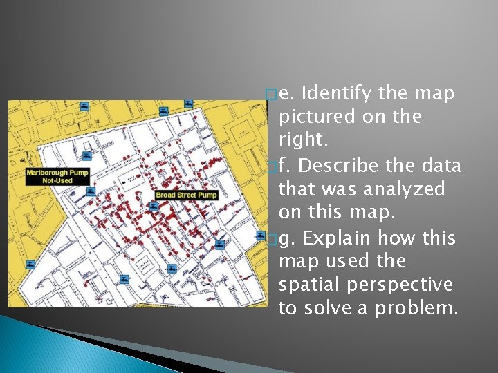
� e. Identify the map pictured on the right. � f. Describe the data that was analyzed on this map. � g. Explain how this map used the spatial perspective to solve a problem.
- Slides: 41