Unit 1 Physical Patterns and Processes Earth Sun


 – allows for the transmission of")


- Slides: 20
Unit 1 : Physical Patterns and Processes
Earth- Sun Relationship • The Earth-Sun relationship is responsible for annual changes in the seasons • Earth is tilted at a 23. 5 degrees • Tropic of Cancer is the farthest northern point where sun rays hit earth directly (Summer Solstice), longest day of the year • Tropic of Capricorn is the farthest southern point where sun rays hit earth directly (Winter Solstice), shortest day of the year • In Southern Hemisphere, November, December, and January are the warmest months. Coldest months are May, June, and July • Northern Hemisphere is complete opposite, warmest months are May, June, and July. Coldest months are November, December, and January
Tropic of Cancer Equator Tropic of Capricorn Prime Meridian
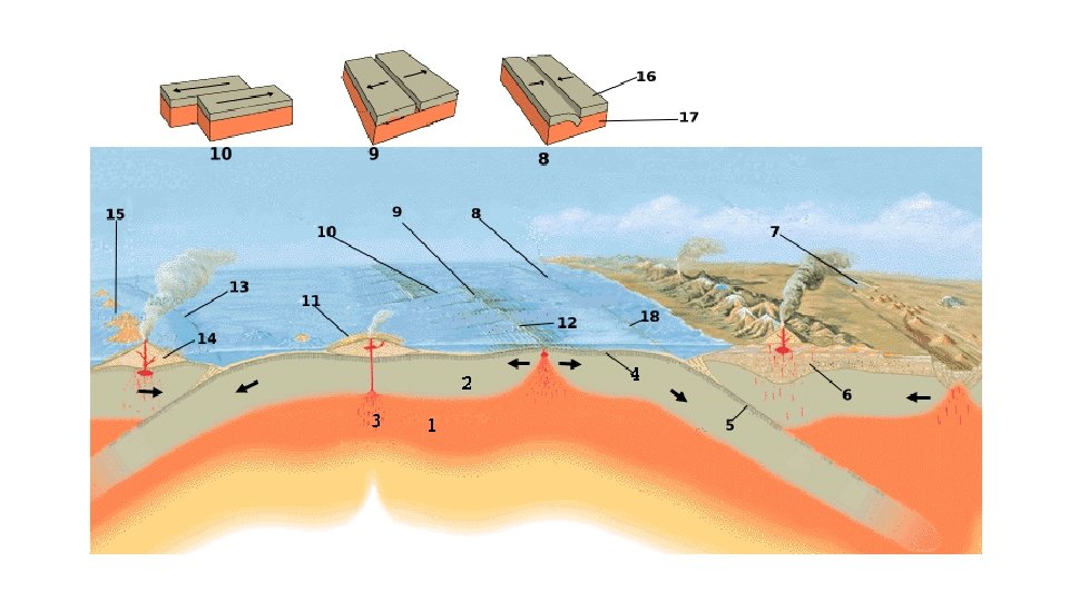
Processes that Affect the Environments 1. Weather – refers to day conditions of the atmosphere and is affected by solar energy and pressure systems and cloud cover. 2. Tectonic forces – refers to the plates that make up the earths crust • • Plate movements cause earthquakes and volcanic activity Divergent Plates – tectonic plates move apart Convergent Plates – one tectonic plate is forced under another tectonic plate Transform Boundaries – refers to areas where tectonic plates slide past each other
3. Erosion – refers to the movement of weathered material by wind, water, or ice • Water Erosion – evident in Rivers and along coastlines • Wind Erosion – movement of particles from one location to another, creating physical features such as sand dunes • Ice Erosion – occurs when large ice structures, transport and deposit material 4. Soil Building – refers to the physical creation of weathered rock, organic matter, air and water • Erosion is part of the soil-building process
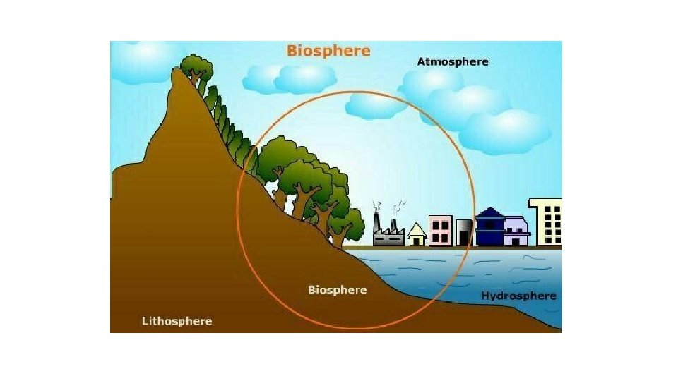
Processes Affecting the Spheres • Lithosphere – the outermost shell of the earth • Atmosphere – the layer of air that surrounds the earth • Hydrosphere – comprised of all the water that is on earth including lakes, rivers, oceans, and underground supplies • Biosphere – refers to the living plants and animals that inhabit the land water on the earth, also known as ecosystems
• Hurricanes – causes high winds and large amounts of rainfall affecting the atmosphere, hydrosphere, and lithosphere • Can uproot plants, stones, or other loose materials affecting the lithosphere • Can cause loss of plant, animal and human life affecting the biosphere • El Nino – impacts precipitation levels causing periods of drought and flooding affecting all spheres • Earthquakes – causes fractures in the lithosphere; possible damage to lives in the biosphere • Tsunamis are created in the hydrosphere and threaten the lithosphere • Volcanoes – releases gases and ash into the atmosphere; released ash affects lithosphere and hydrosphere • Lava flows affect the lithosphere • Eruptions can create crates in the lithosphere
Different Landforms • Mountains, Islands, rifts, volcanoes – caused by tectonic forces • Plains – erosion from water, ice or wind; flowing lava • Atolls – growth of coral reefs around a volcano • Valleys – glacial erosion and tectonic forces • Deltas – soil building and water erosion • Canyons – water erosion • Fjord – glacial erosion • Sand dunes – wind erosion
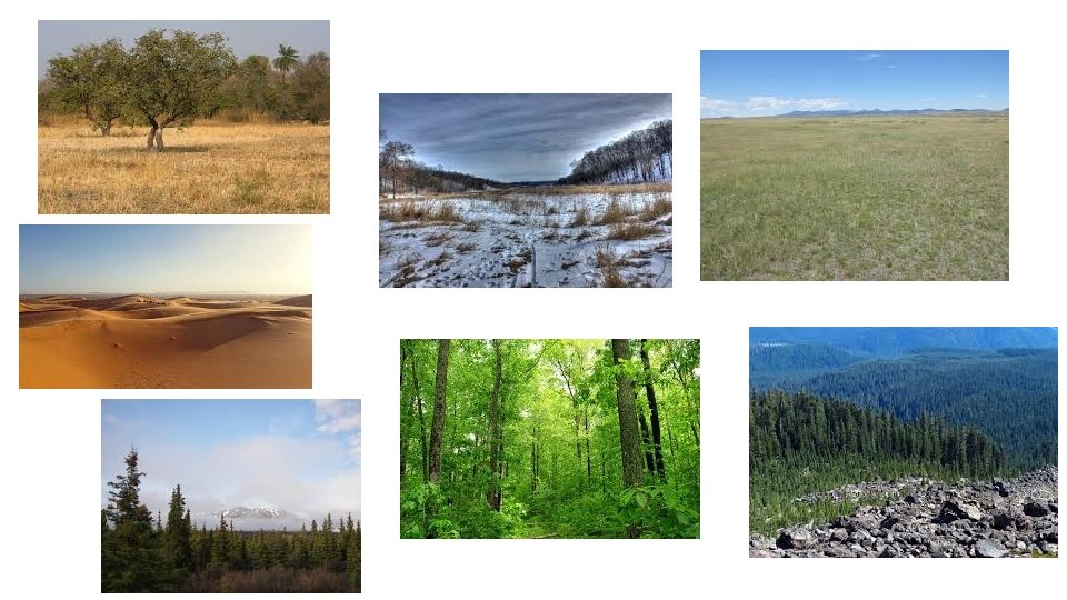
Biomes • Forests • Temperate Deciduous Forest – found in the mid latitudes where the climate is characterized by plentiful rainfall, moderate temperatures, and cool winters. Trees lose their leaves after changing colors in the fall • Temperate Coniferous Forest – found in temperate climate zones where the summers are warm and the winters are cool and rainfall is adequate. Evergreens predominate. Mainly found in Coastal Areas that experience mild winters and heavy rainfall • Taiga or Boreal Forest – The World’s Largest biome is located in the highest northern latitudes where average temperatures and average precipitation are low and are characterized by evergreen coniferous forests. Animals living in this biome must adapt to very cold temperatures
• Grasslands • Steppes – found in climates that are experience low levels of rainfall, absence of trees. This biome is home to large grazing animals • Savannas – found in climates that experience low levels of rainfall, have more than steppes and therefore have some trees. Home to a variety of large animal species • Deserts • Are distinguished by a lack of rainfall, typically less than ten inches per year and can be hot or cold. Climate conditions require the plants and animals to adapt to extreme conditions • Tundra or Artic Biome • Found almost entirely in the Northern Hemisphere near the Artic Ocean, characterized by low amounts of precipitation and extremely cold temperatures. • Permafrost or frozen subsoil makes it difficult to sustain plant life in this biome • This Biome lacks trees and is distinguished by small shrubs and low growing plants • Plants adapt to colder climate conditions and thrive in the short summer and spring
Innovations • Transportation • Railroads allowed for faster transportation of goods to market and the settlement of people to varied locations • Ex. Transcontinental railroad, Trans-Siberian Railroad, and the Trans-Canadian Railroad • Highways and roads have allowed for economic activities to move from city center • Ex. Interstate Highway system in the U. S. and the Interoceanic Highway in South America • Canals • Dredging allows for the creation of deeper ports • Ex. Hong Kong airport
• Energy Innovations • Wind/Solar Power allow for the renewable creation of energy • Dams/Hydroelectric Power provide for widespread access to electricity and control of flooding • Oil Drilling/ Hydraulic fracturing increase the amount of oil extracted; may have environmental implications • Nuclear Power provides an alternative source of energy but poses a risk for human exposure to radiation
GPS and GIS • Global Positioning System (GPS) – allows for the transmission of location and weather information • Has facilitated precision in location and aided in navigations systems • Use in military, businesses and individuals • Geographic Information Systems (GIS) – integrated data to produce charts, maps, and globes allowing for the visualization of geographic data that can be used to analyze relationships and patters • Internet has allowed information to be easily accessible worldwide
Elevation, Latitude, Wind Systems Elevation q. Location in Higher elevations experience cooler Temperatures and high amounts of precipitation in the form of snow. Thin air in high elevations lacks the ability to hold heat causing both cooler temperatures and precipitation Latitude • Latitude has a significant impact on temperature with locations nearest the equator experiencing high temperatures and those near the poles experiencing cold temperatures. Latitude has a slight influence on precipitation, mostly near the equator where rising hot air contributes to the humidity Wind Systems • Serve to move warm or cool air across the earth’s surface and to distribute precipitation around the globe. Wind systems can bring moist air from across an ocean or dry air from across land. Monsoons ar an example of a wind pattern that brings moist air across areas of South Asia causing heavy Rainfall. Temperatures in coastal locations are affected by the temperature of the water nearby and the winds that cross over the water
Ocean Currents, Mountain Barriers, Ocean Currents • Ocean currents help to distribute heat away from the equator. Warm water at the equator circulates toward the tropics. Water from the tropics circulates to the poles where the water cools and then circulates back toward the equator. Wind systems have an effect on ocean currents and like wind systems, ocean currents also transfer precipitation around the world Mountain Barriers • Mountain Barriers have a great effect on precipitation. As air rises to pass over a mountain barrier it releases moisture as the air cools. This creates a wet side or windward side and a dry side or leeward side to mountain barriers. The windward side of a mountain is generally on the side closest to ocean. This process is referred to as orographic precipitation or the rain shadow effect. Windward sides of mountain ranges receive higher average precipitation and leeward sides of mountain ranges tend to receive lower average precipitation
Climate Regions • Climate regions are characterized by a combination of average temperatures with average amounts of precipitation • 5 major climates: Polar, temperate, tropical, arid, and highland • Polar climate region is located in the higher latitudes and is characterized by generally low temperatures, low precipitation, long winters and short summers. Within the polar climate region are the subregions of subartic, tundra, and ice cap • Temperate climate region is located in the mid latitudes and is characterized by seasonal temperature variations and seasonal precipitations variations. Within the temperate climated region are thde sub regions of marine west coast, Mediterranean, humid subtropical, and humid continental. Humid subtropical climates vary around the globe
• Tropical climate region is located in the low latitudes and characterized by warm temperatures year around abundant rainfall. Within the tropical climate region are the sub regions of tropical rainforest and savanna • Arid/dry climate region is characterized by variations in temperatures and low rainfall. This climate zone is most commonly sub divided into desert or steppe • Highland climate regions are located in higher elevations no matter the latitude