Unit 1 Map Skills VISUAL VOCABULARY LATITUDE Imaginary

Unit 1 Map Skills VISUAL VOCABULARY

LATITUDE � Imaginary lines drawn on maps from east to west to locate places north or south of the equator

EQUATOR � An imaginary line that runs horizontally through the center of the Earth, dividing the Northern and Southern hemispheres.

LONGITUDE � Imaginary lines drawn on maps from north to south to locate places east or west of the prime meridian

PRIME MERIDIAN � An imaginary line that runs through the center of the Earth vertically dividing the Eastern and Western hemispheres.

MAP KEY �A small chart included on a map that gives descriptions of what symbols are used and what they stand for.

SCALE � Represents the distance between two locations on the map. Ex: 1 inch on the map equals 1 mile on the ground

COMPASS ROSE �A design on a map that shows directions

CARDINAL DIRECTIONS � The four major compass points of North, South, East, West used to navigate a map

INTERMEDIATE DIRECTIONS � The in-between compass points of Northeast, Northwest, Southeast, Southwest

SYMBOL �A picture that is used to represent an object on a map

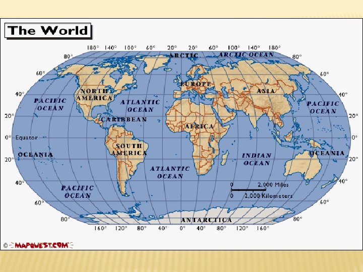
MAP SKILLS How do we find places on maps?

LATITUDE � Lines run horizontally � measured in degrees. � The Equator is 0 degrees Latitude. � Latitude lines are called parallels.

equator � imaginary belt that runs halfway point between the North Pole and the South Pole.

LATITUDE NORTH POLE 90 Lines of North latitude are numbered from 0° to 90° are N. L. [ 80 70 60 50 40 30 20 10 ] 10 20 30 40 50 60 70 80 SOUTH POLE 90 Lines of South latitude are numbered from 0° -90° are S. L.

LATITUDE THE NORTH POLE IS AT 90° N The equator is at 0° latitude. It is neither north nor south. It is at the center between THE SOUTH POLE north and IS AT 90° S south. 40° N is the 40° line of latitude north of the equator. 40° S is the 40° line of latitude south of the equator.

MAJOR LINES OF LATITUDE � North Pole � Arctic Circle � Tropic of Cancer � Equator � Tropic of Capricorn � Antarctic Circle � South Pole

LONGITUDE � � � Prime Meridian is the main line of longitude Lines of Longitude run vertically. Called Meridians East or West of the Prime Meridian is found in Greenwich, England is 0 degrees Longitude.

LONGITUDE LINES OF LONGITUDE BEGIN AT THE PRIME MERIDIAN. 60° W is the 60° line of longitude west of the Prime. W Meridian. E 60° E is the 60° line of longitude east of the Prime Meridian. The Prime Meridian is located at 0°. It is neither east or west

180° East Longitude West Longitude North Pole LONGITUDE N W PRIME MERIDIAN E S Lines of longitude are numbered east from the Prime Meridian to the 180° line and west from the Prime Meridian to the 180° line.

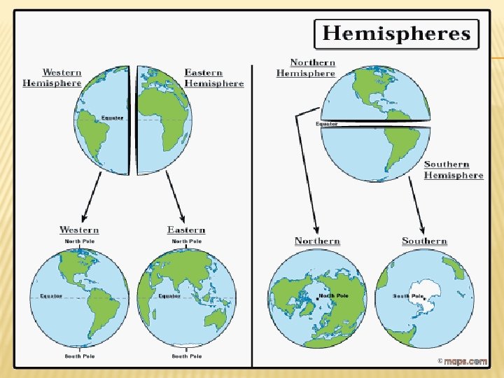
HEMISPHERES � The Equator splits the earth into the northern and southern hemisphere � The Prime Meridian splits the earth into Eastern and Western hemisphere

CAN YOU UNDERSTAND THIS LEGEND?

AGE EXPECTANCY Legend

GLOBE SAYS � This game follows the same rules as “Simon Says” � Body parts represent the major lines of latitude �Top of head – North Pole �Ears – Arctic Circle �Shoulders – Tropic of Cancer �Waist – Equator �Knees – Tropic of Capricorn �Shins – Antarctic Circle �Toes – South Pole

“HOW TO” FOLDABLE N Step #1: Highlight the Equator YELLOW and Prime Meridian PINK Step #2: Draw the Compass Rose in the bottom corner * North, South, East, West, Northeast, Southeast, Northwest, Southwest NW NE E W Step #3: Using the lines made by the highlighted equator and Prime Meridian to label the cardinal directions on the globe. Step #4: Label the Hemispheres using the intermediate directions on the inside of the quadrant in the globe. SW SE S
- Slides: 27