TYPE AND CLASSIFICATION OF MAPS THE GLOBE A

TYPE AND CLASSIFICATION OF MAPS

THE GLOBE A globe is a three-dimensional, spherical, scale model of Earth (terrestrial globe or geographical globe) or other celestial body such as a planet or moon. While models can be made of objects with arbitrary or irregular shapes, the term globe is used only for models of objects that are approximately spherical.
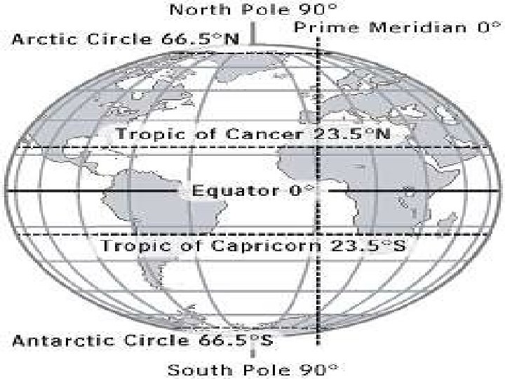

Latitude Lines Imaginary lines running horizontally around the globe. Also called parallels, latitude lines are equidistant from each other. Each degree of latitude is about 69 miles (110 km) apart. Zero degrees (0°) latitude is the equator, the widest circumference of the globe. Latitude is measured from 0° to 90° north and 0° to 90° south— 90° north is the North Pole and 90° south is the South Pole. Longitude Lines Imaginary lines, also called meridians, running vertically around the globe. Unlike latitude lines, longitude lines are not parallel. Meridians meet at the poles and are widest apart at the equator. Zero degrees longitude (0°) is called the prime meridian. The degrees of longitude run 180° east and 180° west from the prime meridian.

Equator Zero degrees latitude. The Sun is directly overhead the equator at noon on the two equinoxes (March and Sept. 20 or 21). The equator divides the globe into the Northern and Southern hemispheres. The equator appears halfway between the North and South poles, at the widest circumference of the globe. It is 24, 901. 55 miles (40, 075. 16 km) long Hemisphere a half of the earth, usually as divided into northern and southern halves by the equator, or into western and eastern halves by an imaginary line passing through the poles. Grid latitude and longitude lines form an imaginary grid over the Earth’s surface.
. The prime meridian runs through the Royal")
Prime Meridian Zero degrees longitude (0°). The prime meridian runs through the Royal Greenwich Observatory in Greenwich, England (the location was established in 1884 by international agreement). The prime meridian divides the globe into the Western and Eastern hemispheres. The Earth's time zones are measured from the prime meridian. The time at 0° is called Universal Time (UT) or Greenwich Mean Time (GMT).

International Date Line Located at 180° longitude (180° E and 180° W are the same meridian). Regions to the east of the International Date Line are counted as being one calendar day earlier than the regions to the west.

Tropic of Cancer A line of latitude located at 23° 30' north of the equator. The Sun is directly overhead the Tropic of Cancer on the summer solstice in the Northern Hemisphere (June 20 or 21). It marks the northernmost point of the tropics, which falls between the Tropic of Cancer and the Tropic of Capricorn A line of latitude located at 23° 30' south. The Sun is directly overhead the Tropic of Capricorn on the summer solstice in the Southern Hemisphere (Dec. 20 or 21). It marks the southernmost point of the tropics. Arctic Circle A line of latitude located at 66° 30' north, delineating the Northern Frigid Zone of the Earth.

Antarctic Circle A line of latitude located at 66° 30' south, delineating the Southern Frigid Zone of the Earth. Globe The most accurate map of the Earth, duplicating its spherical shape and relative size.

MAPS Map Representation of a physical plane with selective information. Maps represent a contain detailed definite area and geographical information.

TYPES OF MAPS Political Map: A political map does not show any topographic features. It instead focuses solely on the state and national boundaries of a place. They also include the locations of cities - both large and small, depending on the detail of the map.

Physical Map: A physical map is one that shows the physical landscape features of a place. They generally show things like mountains, rivers and lakes and water is always shown with blue. Mountains and elevation changes are usually shown with different colors and shades to show relief. Normally on physical maps green shows lower elevations while browns show high elevations.

Topographic map: A topographic map is similar to a physical map in that it shows different physical landscape features. They are different however because they use contour lines instead of colors to show changes in the landscape.

Climate Map: A climate map shows information about the climate of an area. They can show things like the specific climatic zones of an area based on the temperature, the amount of snow an area receives or average number of cloudy days.

Economic or Resource Map: An economic or resource map shows the specific type of economic activity or natural resources present in an area through the use of different symbols or colors depending on what is being shown on the map.

Road Map: A road map is one of the most widely used map types. These maps show major and minor highways and roads (depending on detail) as well as things like airports, city locations and points of interest like parks, campgrounds and monuments.

Thematic Map: A thematic map is a map that focuses on a particular theme or special topic and they are different from the six aforementioned general reference maps because they do not just show natural features like rivers, cities, political subdivisions, elevation and highways.

CLASSIFICATION OF MAPS REFERENCE OR NAVIGATIONAL MAPS These are created to help navigate over the earth surface. These kinds of maps show where particular places are located and can be used to navigate the way to them. A street map or the common highway road map falls into this category. Physical geographers use topographic maps to show the locations of landscape features on the earth.
 of land")
CLASSIFICATION OF MAPS TOPOGRAPHIC MAPS illustrate the horizontal and vertical positions (relief) of land surface features. Topographic maps use contour lines to show elevation (height above sea level). THEMATIC MAPS are used to communicate geographic concepts like the distribution of densities, spatial relationships, magnitudes, movements etc. World climate or soils maps are notable examples of thematic maps.

MAP ESSENTIALS • TITLE • Shows what the subject of the map is. • COMPASS ROSE • It has arrows which point in all 4 principal directions. • SCALE • Used to represent distances between two points on a map.

BAR SCALE A scale on a map which gives distances in miles or kilometers using bars. LEGEND Used to explain what the symbol on a map represents. KEY Another name for a legend on a map. LOCATOR MAP Shows where in the world the area on the map is located.
- Slides: 21