Tropical Cyclone Precipitation Structures Derived from Reflectivity Statistics



- Slides: 23

Tropical Cyclone Precipitation Structures Derived from Reflectivity Statistics Using TRMM PR Robert Rogers and Frank Marks NOAA/AOML Hurricane Research Division Krystal Valde Univ. of Miami/CIMAS and NOAA/AOML Hurricane Research Division Andrew Hagen Department of Meteorology Penn State University

Motivation • Radial, vertical, and temporal distributions of latent heating in tropical cyclones (TC’s) are key parameters in determining TC structure and intensity • While these parameters cannot be directly measured, radar reflectivity provides a proxy means of diagnosing details of the structure of convective and stratiform processes occurring within the TC • From these processes vertical motion and latent heating profiles can be inferred, yielding information on TC structure and intensity • TRMM Precipitation Radar provides valuable information that can be used for many purposes: • identify and compare structure of precipitation features in TC’s • compare statistics of precipitation structures across platforms and numerical models • compare precipitation structures as a function of storm parameters (e. g. , storm intensity, location, environment) • identify possible differences in precipitation structures for different storm evolutions (e. g. , rapid intensification, tropical cyclogenesis)

Methodology • TRMM 2 A 25 Version 6 PR reflectivity profile dataset used • global dataset of tropical cyclone overpasses from 1998 -2006 • Partition areas into separate regions based on precipitation structure • eyewall, rainband, stratiform regions (for storms of hurricane strength only) • convective/stratiform partitioning (for systems of tropical depression, tropical storm, and hurricane strength) • partitioning based on vertical profile of PR reflectivity • Statistics of reflectivity profiles for different regions calculated and compared

Precipitation structures diagnosed from TRMM PR Isabel 2003 eyewall B height (km) A stratiform rainband eyewall A distance (km) B

Precipitation structures diagnosed from TRMM PR Mean reflectivity profiles for different storm regions N=118 orbits 64 storms

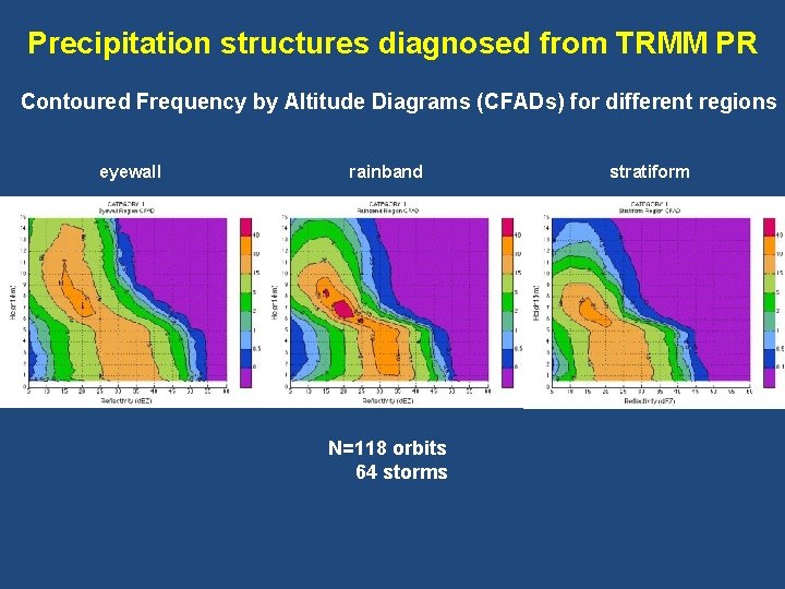
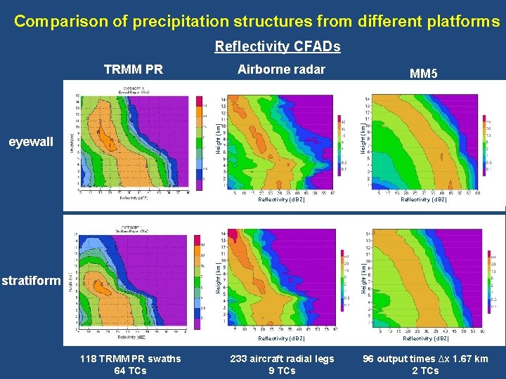
Precipitation structures diagnosed from TRMM PR Contoured Frequency by Altitude Diagrams (CFADs) for different regions eyewall rainband N=118 orbits 64 storms stratiform

Comparison of precipitation structures from different platforms Reflectivity CFADs Airborne radar eyewall MM 5 Height (km) TRMM PR stratiform 118 TRMM PR swaths 64 TCs Reflectivity (d. BZ) Height (km) Reflectivity (d. BZ) 233 aircraft radial legs 9 TCs 96 output times ∆x 1. 67 km 2 TCs

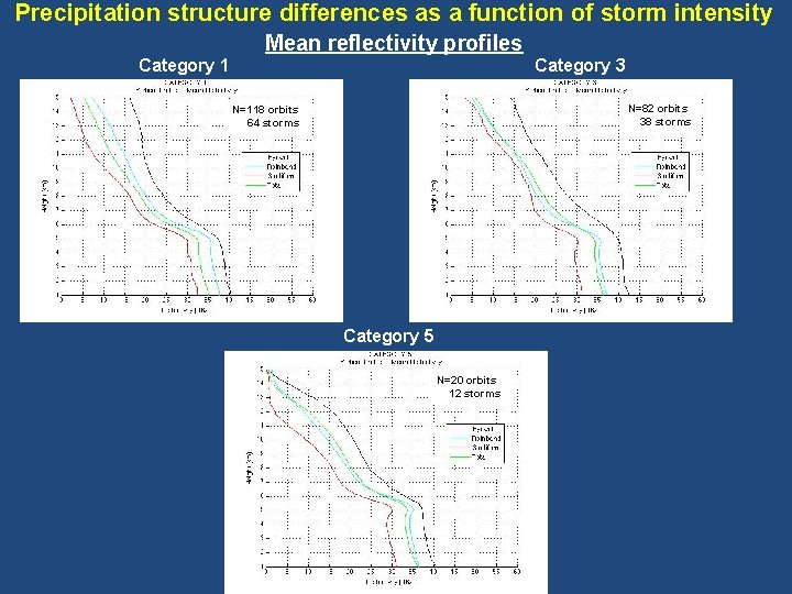
Precipitation structure differences as a function of storm intensity Mean reflectivity profiles Category 1 Category 3 N=82 orbits 38 storms N=118 orbits 64 storms Category 5 N=20 orbits 12 storms

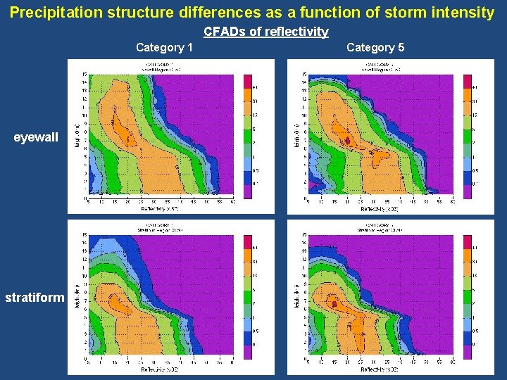
Precipitation structure differences as a function of storm intensity CFADs of reflectivity Category 1 eyewall stratiform Category 5

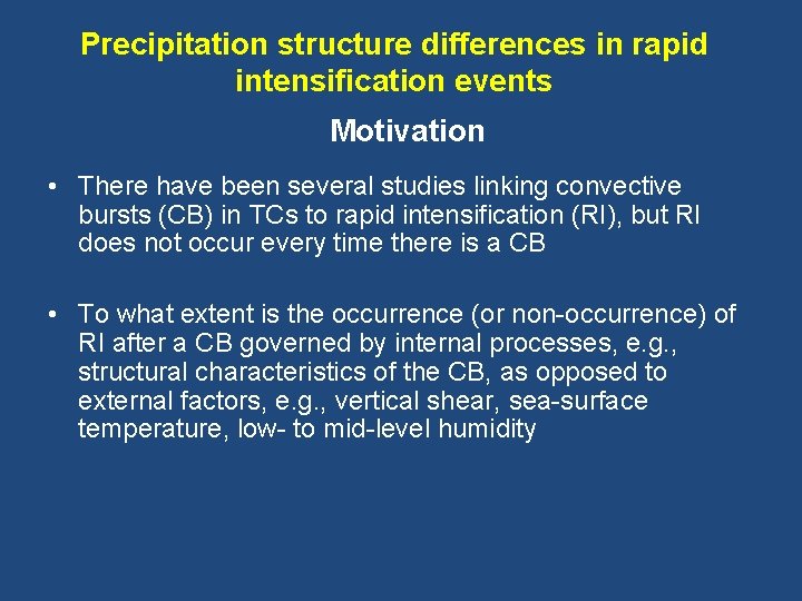
Precipitation structure differences in rapid intensification events Motivation • There have been several studies linking convective bursts (CB) in TCs to rapid intensification (RI), but RI does not occur every time there is a CB • To what extent is the occurrence (or non-occurrence) of RI after a CB governed by internal processes, e. g. , structural characteristics of the CB, as opposed to external factors, e. g. , vertical shear, sea-surface temperature, low- to mid-level humidity

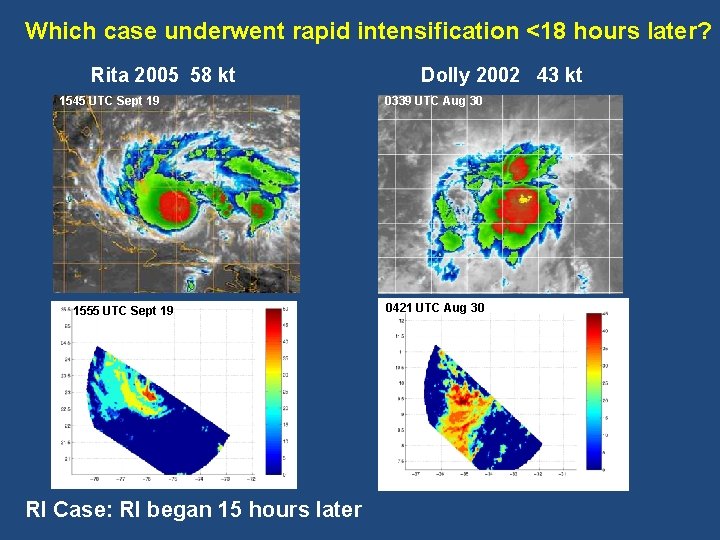
Which case underwent rapid intensification <18 hours later? Rita 2005 58 kt 1545 UTC Sept 19 1555 UTC Sept 19 RI Case: RI began 15 hours later Dolly 2002 43 kt 0339 UTC Aug 30 0421 UTC Aug 30

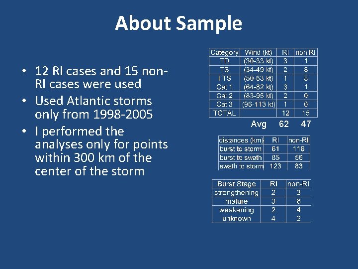
Methodology • Used Atlantic storms only from 1998 -2005 • Identified CB cases, defined as: • Half degree by half degree or larger area of <-70 ºC cloud tops on GOES IR • Must persist for at least 3 hours • Center of CB must be within 200 km of center of storm • CB must have at least some area of <190 K brightness temperature using 85 GHz PCT • Associated CB cases with RI events, defined as 30 -kt increase in maximum sustained winds in 24 hours by NHC’s Best Track. RI had to occur within 24 h of CB. • Examined statistics of reflectivity fields from TRMM PR overpasses for RI (12 cases) and non-RI (15 cases) events that had a CB associated with them • Partitioned data into convective and stratiform regions, dependent on vertical profile of reflectivity

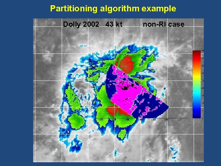
Partitioning algorithm example Dolly 2002 43 kt non-RI case

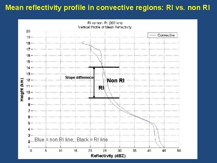
Height (km) Mean reflectivity profile in convective regions: RI vs. non RI Slope difference Non RI RI Blue = non RI line; Black = RI line Reflectivity (d. BZ)

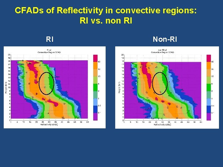
CFADs of Reflectivity in convective regions: RI vs. non RI RI Non-RI

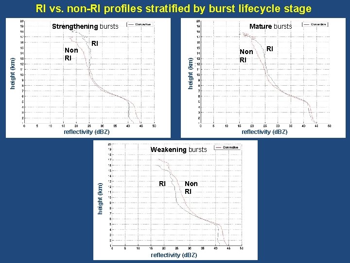
RI vs. non-RI profiles stratified by burst lifecycle stage Mature bursts RI height (km) Non RI RI RI reflectivity (d. BZ) Weakening bursts height (km) Strengthening bursts RI Non RI reflectivity (d. BZ)

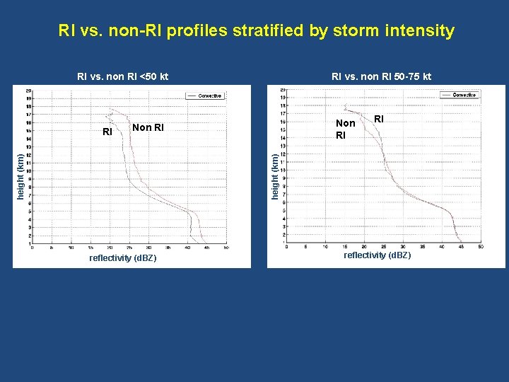
RI vs. non-RI profiles stratified by storm intensity RI vs. non RI <50 kt Non RI RI height (km) RI RI vs. non RI 50 -75 kt reflectivity (d. BZ)

Summary • PR reflectivity profiles provide information on the vertical structure of different precipitation regions within tropical cyclones, can distinguish among them • Distinct differences between platforms, biases from numerical models evident • Reflectivity mean profiles extend higher (lower) for weaker (stronger) tropical cyclones, differences less pronounced for lower altitudes • Reflectivity distributions are broader (narrower) for weaker (stronger) tropical cyclones • Reflectivity profiles decrease less (more) rapidly with height at high altitude for systems that undergo (do not undergo) rapid intensification after a convective burst – vertical motions in the convective regions stronger in RI events? • Differences in slope of reflectivity profiles evident for RI cases as a function of burst lifecycle stage, not so for non-RI cases • Differences in slope of reflectivity between RI and non-RI cases evident for stronger tropical cyclones, not as evident for weaker tropical cyclones

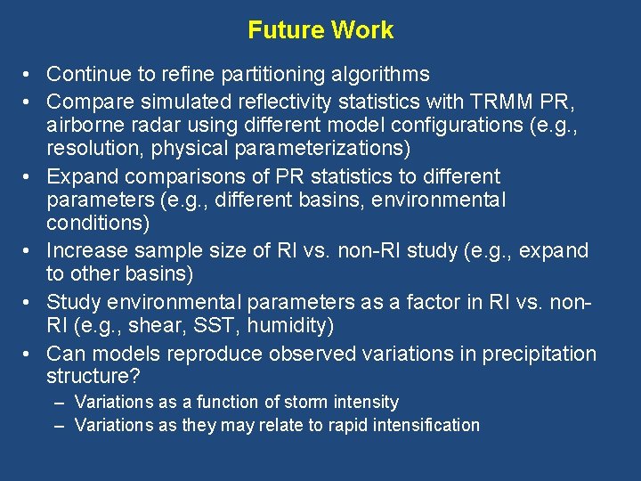
Future Work • Continue to refine partitioning algorithms • Compare simulated reflectivity statistics with TRMM PR, airborne radar using different model configurations (e. g. , resolution, physical parameterizations) • Expand comparisons of PR statistics to different parameters (e. g. , different basins, environmental conditions) • Increase sample size of RI vs. non-RI study (e. g. , expand to other basins) • Study environmental parameters as a factor in RI vs. non. RI (e. g. , shear, SST, humidity) • Can models reproduce observed variations in precipitation structure? – Variations as a function of storm intensity – Variations as they may relate to rapid intensification

Supplementary slides

About Sample • 12 RI cases and 15 non. RI cases were used • Used Atlantic storms only from 1998 -2005 • I performed the analyses only for points within 300 km of the center of the storm Avg 62 47

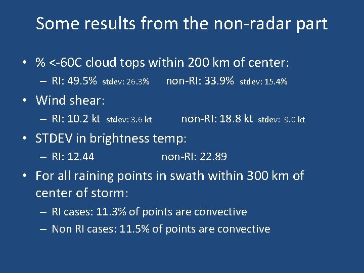
Some results from the non-radar part • % <-60 C cloud tops within 200 km of center: – RI: 49. 5% stdev: 26. 3% non-RI: 33. 9% stdev: 15. 4% • Wind shear: – RI: 10. 2 kt stdev: 3. 6 kt non-RI: 18. 8 kt stdev: 9. 0 kt • STDEV in brightness temp: – RI: 12. 44 non-RI: 22. 89 • For all raining points in swath within 300 km of center of storm: – RI cases: 11. 3% of points are convective – Non RI cases: 11. 5% of points are convective

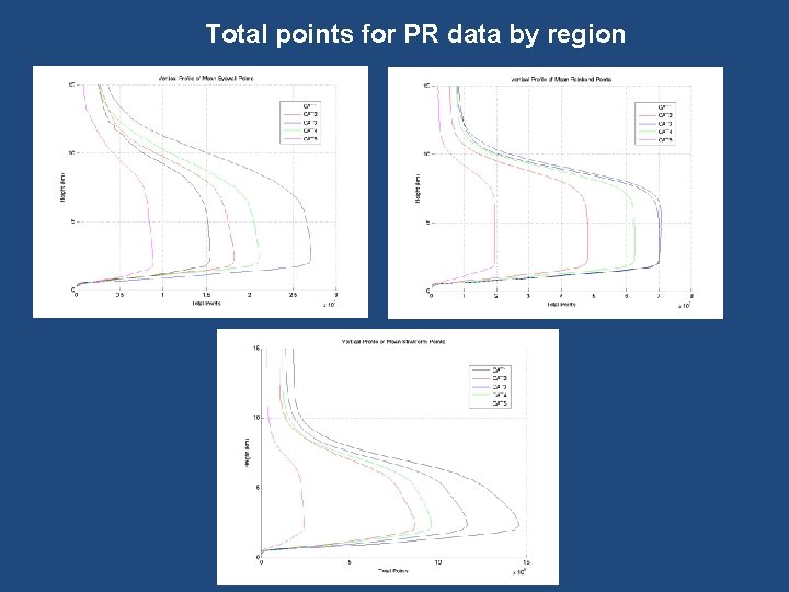
Total points for PR data by region