TRANSPORTATION PLANNING AND ENGINEERING TE501 Transportation Problems and

TRANSPORTATION PLANNING AND ENGINEERING TE-501 Transportation Problems and Models in Transportation Lecture # 2 Engr. Hina Saleemi Assistant Professor Department of Transportation Engineering & Management University of Engineering & Technology, Lahore 1

Lecture Outline • • • Transportation Problems Transportation Goals and Objectives Time Horizon Travel Demand Forecast Study Area Traffic analysis Zone Data Collection Transportation Inventories Highway Planning Study Travel Decisions System Descriptive Model

Transportation Problems § § § § Service Related Congestion Inadequate Capacity Higher user costs Safety Issues Right-of-way and relocation issues Air Pollution Noise Other Factors Affecting Transportation § Population growth and dispersion § Increased automobile ownership

Transportation Goals and Objectives Goals related to transportation service, impact and affecting factors are: § Increased access § Efficiency and Economy § Conservation of natural resources § Performance measures § Travel times § Constraints and Standards § Budget

Transportation Planning-Time Horizons Short term transportation planning : Intended for projects implemented in 1 to 3 years to provide better management of existing facilities e. g Traffic signal retiming, transit improvements. Long term transportation planning Considers projects to be constructed over a 20 year period. Adding new highway elements, adding bus lines or freeway lanes, etc.

Travel Demand Forecasting Used to establish vehicular volumes on future or modified transportation system alternatives. Urban transportation forecasting process includes the following elements: § Define the study area § Data collection or inventories § Analysis of existing conditions and calibration of forecasting techniques § Forecast of future travel demand § Analysis of results

Transport Survey Design This series of lectures is designed to cover important aspects related to Transport Surveys including • Information needed • Study area definition • Zoning • Types of movement • Types of surveys • Survey design • Sampling methods and size • Data processing and analysis

Information-needed Typical information required from the data collection can be grouped into four categories, enumerated as below. Socio-economic data: Information regarding the socio-economic characteristics of the study area. Important ones include income, vehicle ownership, family size, etc. This information is essential in building trip generation and modal split models. Travel surveys: Origin-destination travel survey at households and traffic data from cordon lines and screen lines. Former data include the number of trips made by each member of the household, the direction of travel, destination, the cost of the travel, etc. The latter include the traffic flow, speed, and travel time measurements. These data will be used primarily for the calibration of the models, especially the trip distribution models.

Information-needed Land use inventory: This includes data on the housing density at residential zones, establishments at commercial and industrial zones. This data is especially useful for trip generation models. Network data: This includes data on the transport network and existing inventories. Transport network data includes road network, traffic signals, junctions etc. The service inventories include data on public and private transport networks. These particulars are useful for the model calibration, especially for the assignment models.

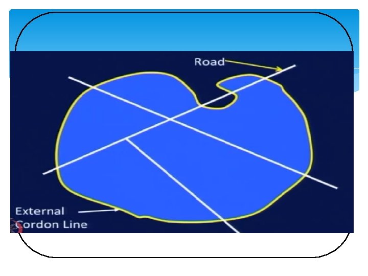
THE STUDY AREA Once the nature of the study is identified, the study area can be defined to encompass the area of expected policy impact. The study area need not be confirmed by political boundaries, but bounded by the area influenced by the transportation systems. The boundary of the study area is defined by what is called as external cordon or simply the cordon line.

Definition of The Study Area The study area for which transportation facilities are being planned is first of all defined. For planning at the urban level, the study area should embrace the whole contribution containing the existing and potential continuously built up areas of the city. Interactions with the area outside the cordon are defined via external stations which effectively serve as doorways to trips, into, out of, and through the study area.

Definition of The Study Area The imaginary line representing the boundary of the study area is termed as the ‘‘ external cordon line’’ The area inside the external cordon line determines the travel pattern to a large extent, and as such, it is surveyed in great detail. The land-use pattern and the economic activities are studies intensively and detailed surveys (such as the home-interview) are conducted in the area to determine the travel characteristics. On the other hand, the area outside the cordon line is not studied in such details.

Definition of the Study Area In short, study area should be defined such that • majority of trips have their origin and destination in the study area, and • should be bigger than the area-of-interest covering the transportation project.

Selection of External Cordon Line The selection of the external cordon line for urban transportation planning should be done carefully with due consideration to the following factors: i. The external cordon line should circumscribe all areas, which are considered likely to be developed during the planning period. ii. The external cordon line should contain all areas of systematic daily life of the people oriented towards the city centre and should in effect be the commuter shed.

Selection of External Cordon Line iii. The external cordon line should be continuous and uniform in its course so that movements cross it only once. The line should intersect roads where it is safe and convenient for carrying out traffic survey. iv. The external cordon line should be compatible with the previous studies of the area or studies planned for the future.

Zoning for Transportation Planning The defined study area is sub-divided into smaller areas called zones or traffic zones. The purpose of such a sub division is to facilitate the spatial quantification of land use and economic factors, which influence travel pattern. Sub division into zones further helps in geographically associating the origins and destinations of travel.

Zoning Zones within the study area are called internal zones and those outside the study area are called external zones. In large study projects, it is convenient to divide the study area into sectors, which are sub divided into zones. Zones can themselves be sub divided into sub-zones depending upon the type of land use.

Zoning A convenient system of coding of the zones will be useful for the study. One such system is to divide the study area into 9 sectors. The central sector (CBD) is designated 0, and the remaining eight are designated from 1 to 8 in a clockwise manner. The prefix 9 is reserved for the external zones. Each sector is sub divided into 10 zones bearing numbers 0 to 9. If necessary, each zone can be divided into 10 sub-zones bearing numbers from 0 to 9.

Zoning

Zoning It would be helpful, if the following points are kept in view when dividing the area into zones: i. The zones should have a homogeneous land use so as to reflect accurately the associated trip making behaviour. ii. Anticipated changes in land use should be considered when sub-dividing the study area into zones. iii. It would be advantageous, if the sub division follows closely that adopted by other bodies (e. g. census department) for data collection. This will facilitate correlation of data.

Zoning iv. The zones should not be too large to cause considerable errors in data. At the same time, they should not be too small either to cause difficulty in handling and analysing the data. As a general guide, a population of 1000 -3000 may be the optimum for a small area; and a population of 5000 -10000 may be the optimum for large urban areas. In residential areas, the zones may accommodate roughly 1000 households.

Zoning v. The zones should preferably have regular geometric form for easily determining the centroid, which represents the origin and destination of travel. vi. The sectors should represent the catchment of trips generated on a primary route. vii. Zones should be compatible with screen lines and cordon lines.

Zoning viii. Zone boundaries should preferably be watersheds of trip making. ix. Natural or physical barriers such as canals, rivers etc. can form convenient zone boundaries.

Points to Consider In addition to the external cordon lines, there may be a number of internal cordon lines arranged as concentric rings to check the accuracy of survey data. Screen lines running through the study area are also established to check the accuracy of data collected from home-interview survey. Screen lines can be conveniently located along physical or natural barriers having a few crossing points. Examples of such barriers are rivers, railway lines, canals, etc.

Zoning

Types of movement The basic movements for which survey data required are: • Internal to internal • External to external • Internal to external • External to internal

Types of movement

Defining the Study Area • Define the study area boundaries. • Further subdivide the area into traffic analysis zones (TAZ).

Traffic Analysis Zone-TAZ Defined as: “a special area defined by state and/or local transportation officials for tabulating traffic-related data” Usually consists of one or more census blocks or block groups.

Traffic Analysis Zone-TAZ Guidelines for establishing TAZ : • Socioeconomic characteristics should be homogeneous. • Intra-zonal trips should be minimized. • Zones should not be created within other zones. • The zone system should generate and attract approximately equal trips, households, population or area. • Zones should be approximately equal in size (smaller in downtown areas and larger on the periphery).

Traffic Analysis Zone-TAZ Other Guidelines : • Boundaries are major roadways or physical barriers such as railways or rivers. • Political and historical boundaries should be used where ever possible. • Zones should use census tract boundaries where possible.

Data Collection This phase provides information about the city and its people. Serves as the basis for developing travel demand estimates Includes information about: • Economic activity (employment, sales volume, income, etc. ) • Land use (type, intensity) • Travel characteristics (trip and traveler profile) • Transportation facilities (capacity, travel speed, etc. ) • Data may be collected using surveys or can be based on previously collected data

Data Collection The data can be collected At home, During the trip, and At the destination of the trip Most details of internal to internal travel can be obtained by home interview survey. The details of internal-external, external-internal, and external travels can be studied by cordon surveys.

Data Collection When collected at home, the data can be wide ranging and can cover all the trips made during a given period. The data collected during the trip is necessarily of limited scope since the procedure yields data only on the particular trip intercepted. At the destination end, the direct interview types of surveys provide data on demand for parking facilities and or the trip ends at major traffic attraction centres such as factories, offices and commercial establishments.

Types of Surveys Home-interview survey Commercial vehicle survey Intermediate public transport survey Public transport surveys Road-side-interview surveys Post-card-questionnaire surveys Registration-number surveys Tag-on-vehicle surveys

Transportation Inventories Involve: • Description of the existing transportation services • Available facilities and their condition • Location of transit routes and schedules • Maintenance and operating costs • System capacity and existing traffic volumes, speed and delay • Property and equipment • Type of data collected depends on the project

Highway Planning Study Data needs: • Functional classification of roadways in system • Freeways, arterials, collectors and local roads • Physical roadway features • Number of lanes, pavement width, traffic signals, traffic control devices • Street and highway capacity for segments and intersections • Travel times along the arterials

Highway Planning Study • Computerized network of existing roadway system is then produced • Network consists of a series of links, nodes and centroids • Link: portion of the highway system that can be described by its capacity, lane width and speed • Node: end point of a link and represents an intersection • Centroid: location within a zone where trips are considered to begin and end

Traveler Decisions Forecasts should be predicated on some understanding of traveler decision. • The various decisions will ultimately determine the: Quantity, • Spatial distribution (by route), and • Temporal distribution of vehicles on a highway network

What is a Modeling is the process of constructing a mathematical object whose behavior or properties correspond in some way to a particular real world system. A mathematical object could be a system of equations, an algorithm, a geometric or algebraic structure, or even just a set of parameters.

System Descriptive Model “A system descriptive model describes logical relationships, such as the system’s whole part relationship that defines its part tree, the interconnection between its parts, the functions that its components perform, or the test cases that are used to verify the system requirements. ”

System Descriptive Model - Develop the system equations. - Solve the system when x 4 = 300

System Descriptive Model -Develop mathematical model Calculate traffic flow on missing lanes when traffic form E to F is at least 50 vehicles Calculate flow on missing lanes when flow from D to E is zero.
 45")
LAB WORK 2 System Descriptive Model (Real Time Problem) 45

Garhi Shahu Intersection • Visit Garhi Shahu Intersection near UET Lahore • Traffic count for one complete hour • Share the data 46
 47")
LAB WORK 3 System Descriptive Model (Real Time Problem) 47

Garhi Shahu Intersection • Traffic volume study for a complete network including two intersections • Develop system descriptive model for that network 48

Any Questions 49
- Slides: 49