Transportation Engineering Prof Rajesh Bhagat Asst Professor CED

Transportation Engineering Prof. Rajesh Bhagat Asst. Professor, CED, YCCE, Nagpur B. E. (Civil Engg. ) GCOE, Amravati M. Tech. (Enviro. Engg. ) VNIT, Nagpur Experience & Achievement: v Selected Scientist, NEERI-CSIR, Govt. of India. v GATE Qualified Three Times. v UGC - NET Qualified in First Attempt. v Selected Junior Engineer, ZP Washim. v Three Times Selected as UGC Approved Assistant Professor. v Assistant Professor, PCE, Nagpur. v Assistant Professor, Cummins College of Engg. For Women, Nagpur v Topper of Pre-Ph. D Course Work at UGC-HRDC, RTMNU Nagpur Mobile No. : - 8483002277 / 8483003474 Email ID : - rajeysh 7 bhagat@gmail. com Website: - www. rajeysh 7 bhagat. wordpress. com
 Introduction & importance of transportation. 2) Road transport characteristics, classification of roads,")
UNIT-I 1) Introduction & importance of transportation. 2) Road transport characteristics, classification of roads, network patterns & principles of alignment. 3) Traffic Engineering: 3 E’s of traffic engineering, various traffic Surveys, intersection-types & parking. 2
 Geometric Design: design of super elevation, I. R. C. standards")
UNIT - II 1) Geometric Design: design of super elevation, I. R. C. standards for geometric design. 2) Road user & road vehicle characteristics. 3) Factors affecting design standards. 4) Cross section elements, horizontal alignment, curves, extra widening, transition curves & vertical alignments. 5) Stopping & overtaking sight distance overtaking zones. 3
 Introduction: Pavement materials 2) Aggregates: Physical & Mechanical properties &")
UNIT – III 1) Introduction: Pavement materials 2) Aggregates: Physical & Mechanical properties & tests on aggregates. 3) Bituminous Materials: classification & sources, properties & tests, Cutback bitumen, Emulsions & IRC/IS standards. 4
 Construction & Maintenance: IRC, MOST specifications for quality & quantity of materials,")
UNIT-IV 1) Construction & Maintenance: IRC, MOST specifications for quality & quantity of materials, techniques, tools and plant for the Earthwork, sub base, base and wearing/ surface course of flexible pavements with gravel, WBM, stabilized Bitumen & Concrete as Construction materials, Drainage, shoulders, maintenance & repairs. 5
 Bridges: Introduction, Components, classification and identification. 2) Data Collection, site selection, Economic")
UNIT-V 1) Bridges: Introduction, Components, classification and identification. 2) Data Collection, site selection, Economic Span, Estimation of flood discharge, waterway, scours depth, depth of foundation, Afflux, clearance and free board. 3) Loads, Forces and Stresses for Bridges. 6
 Railways: Classification, lines and their track standards, gauges, track section, railway terminology")
UNIT-VI 1) Railways: Classification, lines and their track standards, gauges, track section, railway terminology & permanent way. 2) Sleepers: Function, types, merits and demerits, sleeper density, ballast cushion & ballast section. 7
 1 To determine specific gravity of aggregates. 2 To")
PRACTICALS: - (Min. 10 Experiment) 1 To determine specific gravity of aggregates. 2 To determine impact value of given aggregate sample. 3 To determine crushing value of given aggregate sample. 4 To determine flakiness index of given aggregate sample. 5 To determine abrasion value by Los Angeles test. 6 To perform water absorption test on given aggregate sample. 7 To find softening point of given bitumen sample. 8 To perform penetration test for given bitumen sample. 9 To perform flash and fire point for given bitumen sample. 10 To perform ductility test on given bitumen sample. 11 To perform viscosity test on bitumen. 12 To perform CBR test on given soil sample. 13 To perform Marshall Stability Test on bituminous concrete. 14 Bridge site visit. 8
 Highway engineering by Khanna & Justo, Nem Chand & Bros. Pub. 1)")
References: 1) Highway engineering by Khanna & Justo, Nem Chand & Bros. Pub. 1) Bridge Engineering by S. P. Bindra, Dhanpat Rai Publication. 2) A Text Book of Railway Engineering by S. C. Saxena & S. P. Arora, Dhanpat Rai Sons, New Delhi. 3) Indian Road Congress, IRC handbooks , International Code Council. 4) Traffic and Highway Engineering by J. Garber and L. A. Hoel, Thomson Learning, Inc.

Objective of Transportation System: Main objective of a good transportation system is to provide safe, economical, efficient transportation facility for the travel of passengers and transportation of goods. 10
 Transportation is an index of economic, social, cultural, industrial &")
Role of Transportation: 1) Transportation is an index of economic, social, cultural, industrial & commercial progress of a country. 2) Transportation is vital for the economic development of any region, whether it is agricultural or industrial product needs to be transported from production to distribution. 3) Transportation is also required for carrying raw material for production. 4) The whole structure of industry and commerce rests on the well laid foundation of transport. 5) No country or region can ever flourish if it lacks adequate transport facilities. 6) Main role of transportation is to provide safe, economical, efficient transportation facility for the travel of passengers and transportation of goals.
 Economic Activity & Transport: production, supply, consumption, human demand.")
Importance of Transportation System: 1) Economic Activity & Transport: production, supply, consumption, human demand. 2) Social Effects of Transportation: Population have always settled along the routes. 3) Sectionalism: Cultural exchange, living condition improvement, increase of knowledge, etc. 4) Concentration of Population in Urban Area: Employment opportunity & superior facilities. 5) Aspects of Safety, Law & Order: emergency, external aggression, etc. 6) Development in Rural Area: 75 % population living in rural area, balanced development of city & village. 12
 Human portar b) Animal transport c) Road transport 1) 2)")
Classification of Transport: a) Human portar b) Animal transport c) Road transport 1) 2) 3) 4) 5) Human energy Animal energy Petrol & diesel energy Steam energy Electric energy d) Rail transport e) Air transport 13
 Land Transport: Highways,")
Different Mode of Transportation: Classification from Surface Point of View: 1) Land Transport: Highways, Railways, Cableways, etc. 2) Water Transport: Canal ways, River ways, Ocean ways, Lake ways, etc. 3) Air Transport: Airways. Classification based on Freedom to Move: 1) One Degree Freedom: Vehicles are free to move along a line. Ex. Railways. 2) Two Degree Freedom: move along a line as well as laterally. Ex. Ship, bats, etc. 3) Three Degree Freedom: free to move in any plane. Ex. Aero-planes.
 Road Transport: Transportation by road system is the only")
Different Mode of Transportation: 1) Road Transport: Transportation by road system is the only mode which could give maximum flexibility of service from origin to destination, to one & all. Nearest to people 2) Rail Transport: Transportation could be economical between the railway station & advantages for passenger & goods for long distance. (as resistance to traction along the track for the movement is much lower) 3) Water Transport: Transportation is most energy efficient but slow. 4) Air Transport: Fastest among the four modes, Comfortable, energy requirement more, costly & affected by weather condition.

Characteristics Railways Transport Highway Transport Load handling Capacity. Heavier loads at high speed. Low. Right of entry. Not free to all. Free & flexible. Operational Control. Signaling, interlocking & block system. Not required. Tractive Resistance. Less (1/6 th of highway) More. Gradient. Minimum. Steeper Gradient. Constr. /Maintenance. Higher. Less. Origin & Destination. Starting & Destination points are fixed. Door to door service. Length of Haul. Bulk & Heavy goods is cheaper Short distance upto (Convenient). 500 km is convenient. Employment. Less. Higher. Hilly Regions. Not suitable. Suitable. Accident rate. Few. More. Net tonnes-kms/vehicle hr. Higher. Lower. Horse Power. Lesser per tonnes Higher per tonnes.
 Roads are used by passenger car, buses, trucks, 2")
Characteristics of Road Transport: 1) Roads are used by passenger car, buses, trucks, 2 -3 wheel automobile, cycle, animal drawn vehicle & pedestrian. 2) Requires lowest initial investment (C & M) than other mode like railway, airport & harbours. 3) Offers complete freedom to users according to need & convenience. 4) Flexibility in location, direction, speed & timings of travel, which is not available in other modes of transport. 5) Possible to travel directly from respective places of origin to the destination. 6) For short distance saves time & most convenient. 7) Accidents in other modes are more severe & disastrous in spite of various safety measure & strict control. 8) Only mode that offers the facilities to the whole section of society.
 The deficiency in the road development has contributed")
Importance of Roads in India: 1) The deficiency in the road development has contributed to the set back in the growth of agricultural, industrial & commercial sectors in the country. Hence, for balanced development of any country, it is essential to provide a well planned road network connecting all the towns and villages. 2) It is necessary to provide good road links between the villages & market centers. 3) Overall economic progress can be achieved, only if adequate transport facilities are made available between villages. district & commercial centers. 4) It is also important to develop high quality highways, expressways, connecting important urban, industrial & commercial centers. 5) Road developments generates considerable employment potential, which is of additional significance to the developing country. 6) Paved surface in good condition can contribute to 15 to 40 % savings in vehicle operation cost.
 1) The branch of transportation engineering which deals")
Road Engineering: ( Highway Engineering ) 1) The branch of transportation engineering which deals with the design, construction & maintenance of different types of roads is called Road Enginering. 2) The science & technology dealing with roads is generally called Highway Engineering. Traffic: a vehicles, cyclist, pedestrian, etc. travelling together on a road constitute the traffic. Roadway: comprises of carriageway plus shoulder on either side. Motorway : portion of roadway of an urban road reserved for use only by high speed & power driven vehicles. This is also referred as expressway or super highway.
 Development, planning & location of roads. 2) Highway design.")
Scope of Highway Engineering: 1) Development, planning & location of roads. 2) Highway design. 3) Material required for construction & maintenance. 4) Highway traffic performance & control. 5) Economics, finance & administration.
 The first road was constructed in 1900 B. C.")
Development of Road Construction: 1) The first road was constructed in 1900 B. C. by Assyrian empire as per authentic record. 2) Romans are the pioneers in ancient road construction 312 B. C. 3) Roads were constructed on a large scale only during the period of Roman empire.
 Pierre Tresaguet developed an improved method in France by")
Tresaguet Method of Construction: 1) Pierre Tresaguet developed an improved method in France by the year 1764. 2) Subgrade was prepared & a layer of large foundation stones were laid on edge by hand. 3) At the edges of the pavement large stones were embedded edgewise to serve as submerged kerb stones. 4) After that broken stones were packed to a thickness of about 8 cm & compacted. 5) Top wearing course was made of smaller stones & compacted to a thickness of 5 cm & increasing towards center gradually with slope 1 in 45. 6) Thickness of the road need be only 30 cm. 7) Importance given to subgrade moisture & drainage of surface water.
 When Tresaguet was working in France, John Metcalf (1717 -1810) was")
Metcalf Method: 1) When Tresaguet was working in France, John Metcalf (1717 -1810) was working on road construction & development in England. 2) Good Drainage System. 3) He constructed about 290 km of road in northern England.
 Thomas Telford was the founder of the Institution of Civil Engineers")
Telford Method: 1) Thomas Telford was the founder of the Institution of Civil Engineers at London. 2) 1803, A level subgrade was prepared to a width of about 9 m. 3) Large foundation stone were laid with hand with largest face down so as to laid in stable position. 4) The interstices between foundation stones were filled with smaller stone & chipping. 5) The central portion of about 5. 5 m width was covered with two layers of angular broken stones to compacted thickness 10 & 5 cm. 6) Lime mortar with broken stone were also used to lateral stability towards edges of road. 7) Cross slope of about 1 in 45 was maintained. 8) Telford also provided cross drains at intervals of about 90 m.
 1827, John Macadam put forward an entirely new method of road")
Macadam Method: 1) 1827, John Macadam put forward an entirely new method of road construction as compared to all the previous methods. 2) The soil subgrade being the lowest portion of the pavement should be prepared properly & kept drained so as to carry the load transmitted through the pavement. Therefore subgrade was compacted & prepared with a cross slope of 1 in 36. 3) Small size broken stones were spread over the prepared soil subgrade & compacted. Similarly next layer were constructed. 4) This technique helped to improve the load dispersion characteristics even though thickness were less than previous methods. 5) Water Bound Macadam, Penetration Macadam, Bituminous Macadam & Dense Bituminous Macadam method developed with slight modification.
 WBM road construction method is improved method")
Water Bound Macadam Method: WBM Method 1) WBM road construction method is improved method based on Macadam method. 2) Crushed stones mechanically interlocked by rolling & voids filled by screening & binding material with water. 3) Thickness of each compacted layer 7. 5 to 10 cm. 4) Coarse aggregate of size 40 to 90 mm used for sub-base. 5) Subgrade ie lowest portion of pavement is prepared with compacted layer of smaller size broken stones carry the load transmitted. 6) Compacted layer of smaller size stones at bottom replaced the heavy foundation stones used before this. 7) Stresses due to the wheel load of traffic gets decreased at the lower layer of pavement & larger size stones are not necessary at the lowest layer. 8) Compacted stones of smaller size are better for load dispersion. 9) Economical, locally available material is used & not required skilled labor. 10) Maintenance is high & life is less.

WBM Method
 Road were exist in Mohenjo-Daro & Harappa, 25 to")
Road Development in India: 1) Road were exist in Mohenjo-Daro & Harappa, 25 to 35 centuries (B. C. ) 2) Emperor Ashoka had improved the roads. 3) Roads of India were also improved during the Mughal periods. 4) 1865, Lord Dalhousie, Governor General formed PWD & which constructed Grand Trunk Road.
 Road development in India started after initiation")
Progress of Road Development in India: 1) Road development in India started after initiation of the Nagpur Road Plan in the year 1943. 2) The road development works progressed with the implementation of plans with effect from the year 1951 & subsequent road development plan. 3) The total road length in the country has increased from 4 lakh km in the year 1951 to over 42 lakh km now. 4) Only 35 -40% of total revenue from the road transport sector in the country has been invested on road maintenance works & for development plans during the past several decades.
 1927, the central government appointed the Jayakar")
Road Development in India: Jayakar Committee: 1) 1927, the central government appointed the Jayakar Committee to report on the condition of existing roads & to suggest ways to develop the road. 2) Central government should look after all the important road. 3) The road development in the country should be considered as a national interest. 4) An extra tax should be levied on petrol from the road users to develop a road 5) Road development fund called Central Road Fund. It is formed by the year 1929. 6) The semi-official technical body called the Indian Roads Congress (IRC) was formed in 1934, to monitor design & construction of road. 7) A research organization should be instituted to carry out research and development work. 8) The Central Road Research Institute was started in 1950.
 Indian Road Congress is a semi official technical body")
Indian Road Congress: IRC 1) Indian Road Congress is a semi official technical body established by central government as per recommendation of Jayakar committee in 1934. 2) IRC is formed to monitor the standardization, specification, recommendation regarding design & construction of roads. 3) It provide a forum for regular pooling of experience and ideas on all matters affecting the planning, construction and maintenance of roads in India. 4) IRC played important role in the formulation of 20 year road development plans in India. 5) Now IRC has become successful an active body of controlling specifications, standardization and recommendations on materials, design and construction of roads and bridges. 6) The IRC work with Ministry of Road Transport & Also publishes research journals.
 Indian Legislature formed the Central Road Fund in 1929 as")
Central Road Fund: 1) Indian Legislature formed the Central Road Fund in 1929 as per recommendation of Jayakar Committee. 2) At that period the consumers of petrol were charged an extra levy of 2. 64 paisa per litre. 3) Out of annual revenue collected, 20% was to be retained by central government for administration purpose. Balance 80% was to be distributed for construction & maintenance of road.
 In 1939 the motor vehicles Act was brought into effect")
Motor Vehicle Act: 1) In 1939 the motor vehicles Act was brought into effect by Government of India to regulate the road traffic in the form of traffic laws, ordinances and regulations. 2) The three phases primarily covered are control of the driver, vehicle ownership and vehicle operation on roads and in traffic stream. 3) The motor vehicle act has been appended with several ordinances subsequently. The motor vehicle act has been revised in the year 1988.
 A conference of the chief Engineers of all the states")
Nagpur Road Congress: 1) A conference of the chief Engineers of all the states and provinces was conducted in 1943 by the Govt. of India at Nagpur, at initiative of the IRC to finalize the first road development plan for the country as a whole. 2) This is the landmark in the history of road development in India, as it was the first attempt to prepare a co-ordinated road development programme in a planned manner. 3) In this, first 20 year road development plan finalized & popularly known as the Nagpur Road Plan. 4) Target was to build 16 km length of road per 100 Km 2 area of country.
 In 1956 the National Highway Act was passed. 2) The")
National Highway Act: 1) In 1956 the National Highway Act was passed. 2) The responsibility of development and maintenance of the National highway (NH) to be provisionally taken by the central government. 3) The central govt. to be empowered to declare any other highways as NH or to omit any of existing national highways from the list. 4) Also empowered to acquire land for the development of NH. 5) National Highway Authority of India (NHAI) started operating 1995.
: First 20 Year Road Development Plan 1) Responsibility of")
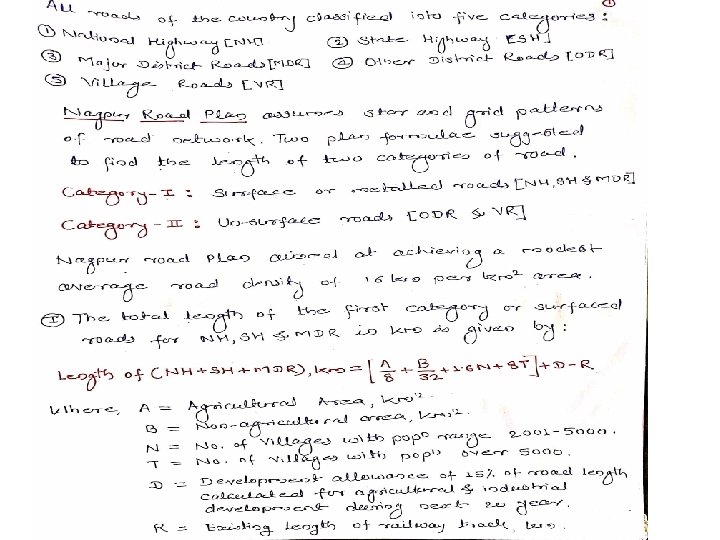
Nagpur Road Plan (1943 -63): First 20 Year Road Development Plan 1) Responsibility of construction & maintenance of national highways was assigned to the central government. 2) Nagpur Road Plan (1943 -63) aiming to provide for 1, 98, 000 km of surface roads and 3, 33, 600 km of un-surfaced roads to reach 16 km road length per 100 sq. km area. 3) The formulae were based on star and grid pattern of road network. But the existing irregular pattern of roads and obligatory points not fitting in the geometric pattern were to be given due consideration. 4) Size of the grid of road in agricultural area would be 16 km so that the maximum distance from the center is 8 km and the average distance of the villages from metaled roads would be less than 3. 2 km. 5) In non-agricultural area the size of the grid is of 64 km sides, the farthest distance from the center to the metaled roads being 32 km. 6) The second category roads are meant to provide internal road system linking small villages with first category roads.

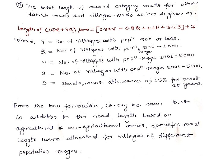
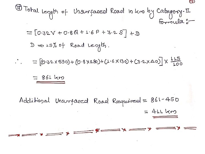
Nagpur Road Plan: First 20 Year Road Development Plan The length of railway tracks in the area was also considered in deciding the length of first category road. Recommendations were made for the geometric standards of roads, bridge specifications & highway organizations. Two formulae were finalized at the Nagpur Conference for deciding the road length for the country as a whole as well as for individual areas (like district) The road network in the country was classified into five categories: 1) National Highways, 2) State Highways, 3) Major District Road, 4) Other District Roads & 5) Village Roads
 Bombay Road Plan 1) First 20")
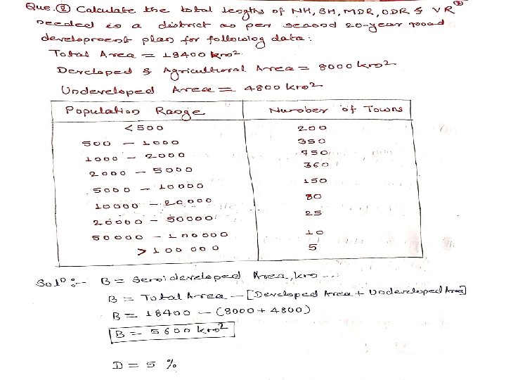
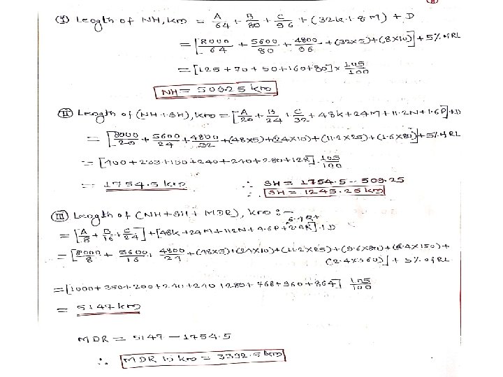
Second 20 Year Road Development Plan: (1961 -81) Bombay Road Plan 1) First 20 year road plan’s target road length was nearly completed earlier in 1961, Hence next 20 year road plan commenced from 1961 by the IRC, sub committee and Chief Engineers. 2) The second road plan expected overall road length of 10, 57330 km by the year 1981. The cost of the plan has been worked out to Rs. 5200 crore. 3) The target of this plan is to provide a total road length of 32 km per 100 sq. km area which is almost double of that achieved up to the year 1961. 4) Maximum distance of any place in a developed area would be 6. 4 km from a metaled road and 2. 4 km from any category of roads. 5) The maximum distance from any place in as semi-developed area would be 12. 8 km from a metaled road. 6) Similarly the maximum distance in an undeveloped area would be 19. 2 km from a metaled road and 8 km from any road.
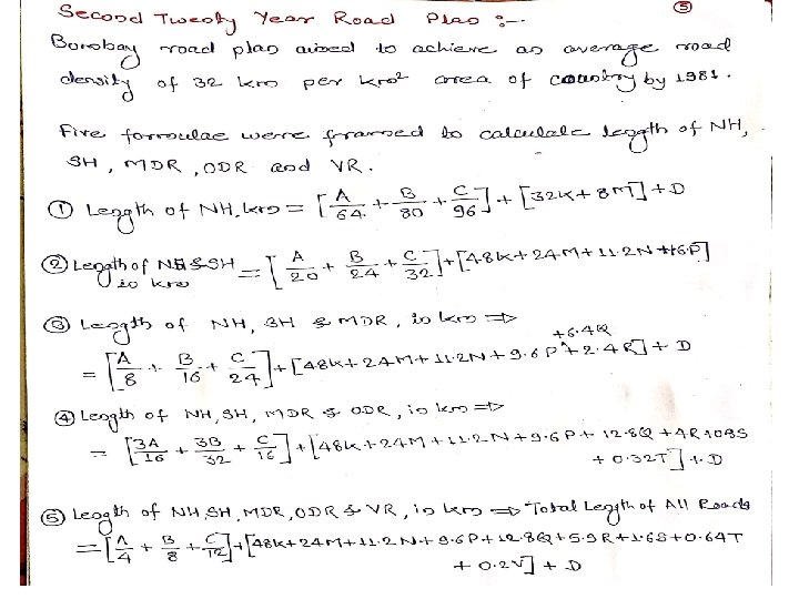
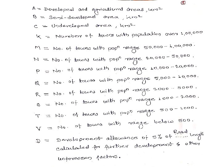
 Bombay Road Plan 7) Every town")
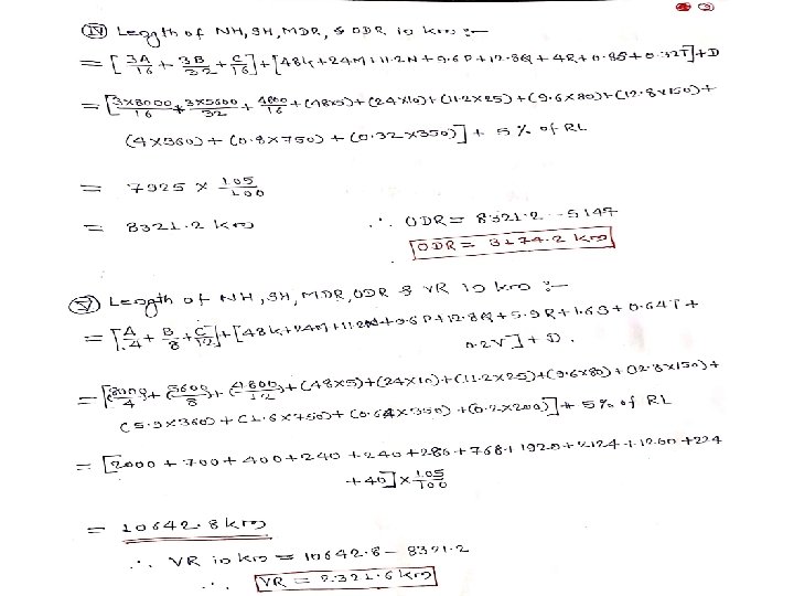
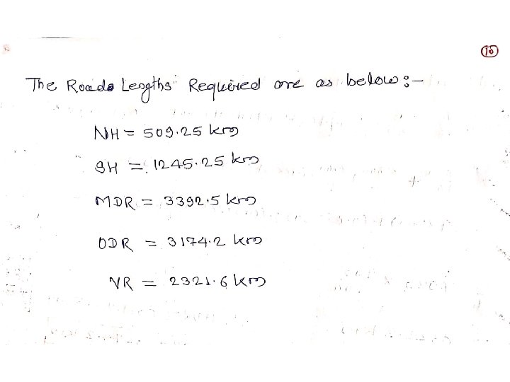
Second 20 Year Road Development Plan: (1961 -81) Bombay Road Plan 7) Every town with population above 2000 in plains and above 1000 in semi hill areas and above 500 in hilly areas should be connected by a metaled road. 8) Expressways 1600 km of length has been included in the proposed target of NH. 9) Length of railway track is considered independent of the road system and hence it is not subtracted to get the road length. 10)Five different formulae were framed to calculate the length of NH, SH, MDR, ODR & VR.
 Lucknow Road Plan 1) Villages having")
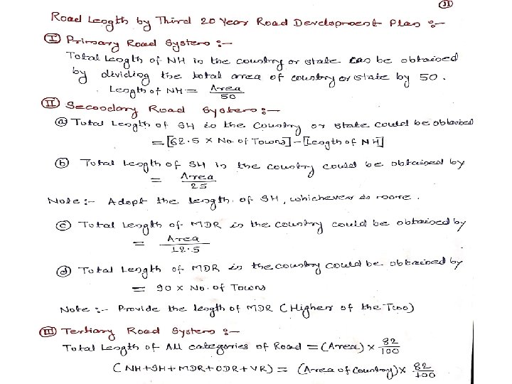
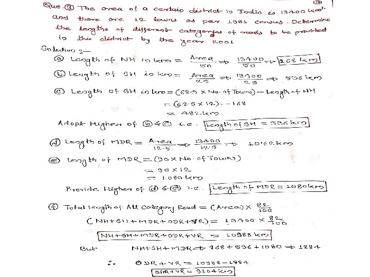
Third 20 Year Road Development Plan: (1981 -2001) Lucknow Road Plan 1) Villages having population over 500 should be connected by all weather roads. 2) Overall density of road in the country should be increased to 82 km per 100 sq. km. 3) NH network should be expanded to form square grid of 100 km sides so that no part of the country is more than 50 km away from a NH. 4) All villages with population over 1500 should be connected by MDR & population 1000 to 1500 by ODR. 5) Villages of population less than 500 should be connected by road within a distance of 3 km in plain & 5 km in hilly area. 6) Roads should be constructed in less industrialized area to attract growth of industries. 7) The existing roads should be improved by rectifying the defects in geometric design. 8) Improving the pavements surface & widening of pavements, as necessary, so that safety & economy is achieved.
 NHAI took up the National Highway Development Projects")
National Highway Development Projects: 2000 1) NHAI took up the National Highway Development Projects by the year 2000. 2) Phase-I : Golden Quadrilateral of total length 5864 km connecting 4 major cities. • Delhi – Mumbai • Mumbai – Chennai • Chennai - Kolkatta • Kolkatta – Delhi 3) Phase-II : • North – South corridor connecting Srinagar to Kanyakumari. • East – West corridor connecting Silchar to Porbandar. 4) Phase-III, IV, V, VI & VII : Development of NH, Expreesways & improvement of urban road network.
 : 1) It is village road development programme")
Pradhan Mantri Gram Sadak Yojana (PMGSY) : 1) It is village road development programme launched in 2000 by central government. 2) The objective is to provide connectivity to all unconnected habitations having population of 500 & above with all weather roads. Road Development Plan: Vision 2021 1) Fourth 20 year Road Development Plan, 2001 -2021 got approved well before 2000. 2) It is prepared by IRC with Ministry of Road Transport.

Classification of Roads: Depending on whether they can be used during different season of the year: 1) All Weather Road: negotiable during all season of the year. 2) Fair Weather Road: traffic may be interrupted during monsoon season. Road Classification as per Nagpur Road Plan based on location & function: 1) National Highway (NH): connecting major ports, foreign highways, capitals of large states & industrial area. NH-4 Thane- Bangalore- Chennai. 2) State Highway (SH): Connecting NH of adjacent highways, district head quarter & important cities within state. Same design speed & geometric design specification used for NH & SH. 3) Major District Roads (MDR): Important roads within a district serving areas of production and markets. Also connecting with other major roads or SH. 4) Other District Roads (ODR): Roads are serving rural areas of production & markets. 5) Village Roads (VR): Connecting villages.
 Primary system")
Modified Classification of Road System by Third Road Development Plan (1981 -2001) Primary system Secondary System Tertiary System or Rural Roads Expressways State Highways Other District Roads National Highways (NH) Major District Roads Village Roads
 Rectangular or")
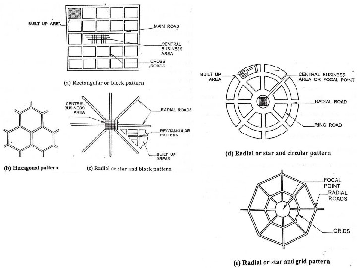
Road Patterns: The various road pattern may be classified as follows: 1) Rectangular or Block Pattern: Adopted in the city of roads of Chandigarh but from traffic operation point is not convenient 2) Hexagonal Pattern: 3) Radial or Star & Block Pattern: 4) Radial or star & Circular Pattern: Road network in Delhi 5) Radial or Star & Grid Pattern: Nagpur Road

 The position occupied by the center line of a")
Road Alignment: Highway Alignment 1) The position occupied by the center line of a road in plan is called road alignment. 2) The position or layout of the center line of highway on the ground is called the alignment. 3) Highway alignment includes both horizontal & vertical alignment of a roadway. 4) The horizontal alignment includes the straight path, the deviations and horizontal curves. 5) Changes in gradient & vertical curves are covered under vertical alignment of roads. 6) Improper alignment leads to more construction cost, maintenance cost, vehicle operation cost & accident rate. 7) Basic requirements of alignment are short, easy, safe & economical.

Highway Alignment
 Obligatory Points: obligatory points through which the road alignment")
Factors Controlling Highway Alignment: 1) Obligatory Points: obligatory points through which the road alignment has to pass are generally due to the topographic & other site condition including natural obstruction. Mountain pass, Bridge to cross a river, etc. There are obligatory points through which the road should not pass like religious places, costly structure, unsuitable land, etc. 2) Traffic: Road alignment should be decided based on the requirements of road traffic. Traffic flow, Traffic volume, Future trends, etc. 3) Geometric Design: Gradient, radius of curve, & sight distance also would govern the final alignment of road. . 4) Economics: While trying to decreasing the initial construction cost, either the future road maintenance cost or vehicle operation cost or both of these may increase considerably. Therefore, economic analysis should be done properly based on life cycle cost. 5) Other Consideration: others factors such as horizontal, vertical alignment, drainage consideration, hydrological factors, political consideration & monotony.
 Topographic Map Study: The process")
Survey to be conducted for finalizing the Alignment: 1) Topographic Map Study: The process of making several possible alternative alignments of a road on the topographical map of the area is known as map study. 2) Reconnaissance Survey: A general examination of a fairly broad stretch of land between the terminal stations in the field, along the proposed alternative alignment marked on the map is known as reconnaissance survey. Engineer visit the site & examine the general characteristics of area. Rapid & rough survey between terminal station. 3) Preliminary Survey: The art of finding the details of alternative alignment found suitable during the reconnaissance survey is known as preliminary survey. Field to office work. 4) Detailed Survey or Location Survey: The detailed examination of the field along the alignment finally recommend during the preliminary survey is called as location survey.
 Traffic Engg. which deals with planning & geometric design of roads")
Traffic Engineering: 1) Traffic Engg. which deals with planning & geometric design of roads on one hand & regulation and control on other hand. 2) Traffic Engineering which deals with the improvement of traffic performance on road network and terminals through systematic traffic studies, scientific analysis & engineering applications. 3) Traffic Engg. is the science of measuring traffic & travel, the study of basic laws relating to traffic flow & generation & application of this knowledge to the professional practice of planning, designing & operating traffic systems to achieve safe & efficient movements of persons & goods. Objectives of Traffic Engg. : 1) To provide efficient flow of traffic. 2) To provide free flow of traffic. 3) To provide rapid flow of traffic. 4) To provide safety to traffic.

Scope of Traffic Engineering: The basic objective of traffic engineering is to achieve efficient, free & rapid flow of traffic, with least number of traffic accidents. 1) Traffic Characteristics 2) Traffic Studies and analysis 3) Planning analysis 4) Geometric design 5) Traffic operation, regulation & control. 6) Road safety aspects 7) Administration & management

3 E’s of Traffic Engineering: Phases of Traffic Engineering are implemented with the help of Engineering, Enforcement & Education is known as 3 E’s. 1) Engineering 2) Enforcement 3) Education Engineering deals with improvement of road geometrics, providing road facilities & installation of suitable traffic control devices. Enforcement is made through traffic laws, regulation & control. Education may be imparted by sufficient publicity and through television.
 Engineering: Engineering deals with improvement of road geometrics, providing road facilities & installation")
1) Engineering: Engineering deals with improvement of road geometrics, providing road facilities & installation of suitable traffic control devices. The geometric design features of the road such as sight distance, width of pavements, width of shoulders, horizontal & vertical alignment design details & intersection design elements are checked & corrected if necessary. 2) Education: Education may be imparted by sufficient publicity and through television, poster, newspaper, etc. Education of road users (pedestrian, passenger, driver, students, etc. ) & Safety drives ( Training courses, workshop, traffic safety week, etc). 3) Enforcement: Enforcement is made through traffic laws, regulation & control. The various measures of enforcement that may be useful to prevent accidents at spot prone to accidents are enumerated here. The motor vehicle rules are revised from time to make them more comprehensive. Speed control, Traffic control devices, Training & supervision, Medical check, special precaution for commercial vehicle, etc.

Traffic Control Devices: The improvement made & facilities provided to the road users so as to obtain efficient, free & rapid flow of traffic with less number of accidents are known as traffic control devices. Types of Traffic Control Devices. 1) Traffic Signs or Road Signs 2) Traffic Markings or Road Markings 3) Traffic Signals 4) Traffic Islands Objective: The main object of providing traffic control devices on road is to provide safe, convenient & economical transportation of persons & goods.
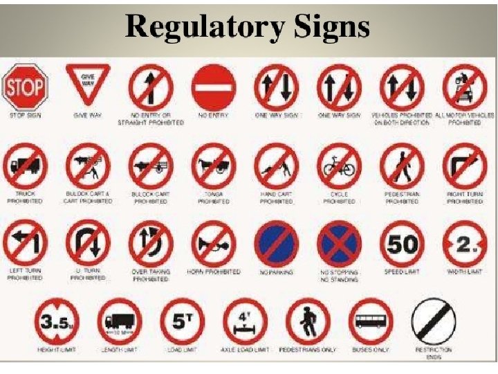
 Regulatory or Mandatory Signs: Gives information to road users")
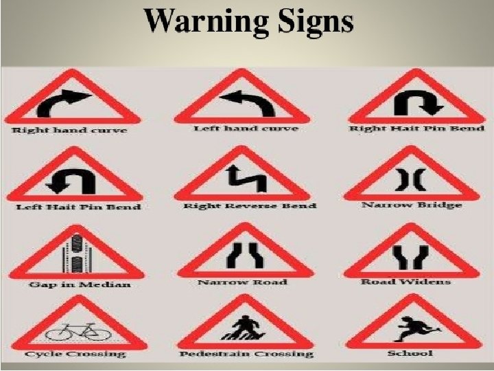
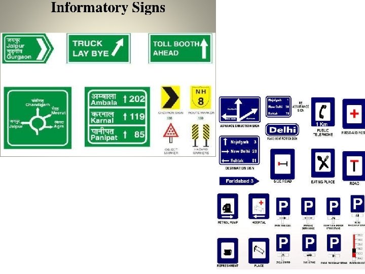
Classification of Road Signs: 1) Regulatory or Mandatory Signs: Gives information to road users certain laws, regulations & prohibitions. 2) Warning or Cautionary Signs: Used to warn the road users in advance of certain hazardous condition that exists on the road way. 3) Informatory Signs : Used to guide the road users along routes, inform them of destination, distance, etc.

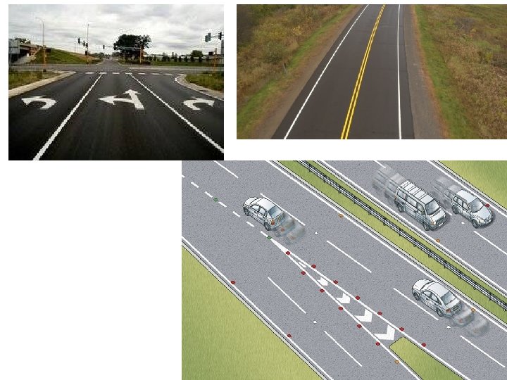
Highway Lighting: It is essential to reduce highway accidents & fatalities that occur during night driving. It necessary at intersection, bridge site, level crossing & places where there is restriction of traffic movements. Pavement Markings: Marking may be generally of white paint. Yellow color marking are used to indicates parking restriction. 1) Center line 2) No passing zone marking 3) Stop lines 4) Cross walk lines 5) Approach to obstruction 6) Parking space limit

Road Intersection: The places where two or more roads are arranged to join or cross at same or different levels are known as road intersection or road junctions. 1) Intersection at Grade: All the roadways join or cross at the same level. Un-channelized & channelized or rotary 2) Grade Separated Intersection: Separation in grade of the intersecting roads is achieved by providing a bridge. Over bridge or under pass.

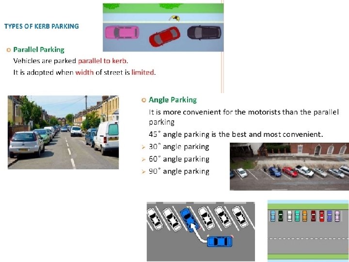
Parking Facility: Vehicles do not keep moving along the road during entire 24 hours of the day. Problems of parking is becoming more & more acute day by day. I. On Street or Kerb Parking: Vehicles are parked along the kerb. Parallel parking & Angle parking. II. Off Street Parking: If perking demand is more, kerb parking can not be permitted in views of traffic congestion. Parking facility at separate place away from the road is known as off street parking. It should be provided at the nearest locations depending upon the availability of space. Surface Parking Lots & Multi Storeyed Parking Garages.
 Surface Parking Lots & 2) Multi")
Off Street Parkings are of two types: 1) Surface Parking Lots & 2) Multi Storeyed Parking Garages.
- Slides: 77