Transportation along a coastline To know how Longshore
 moves material along a")


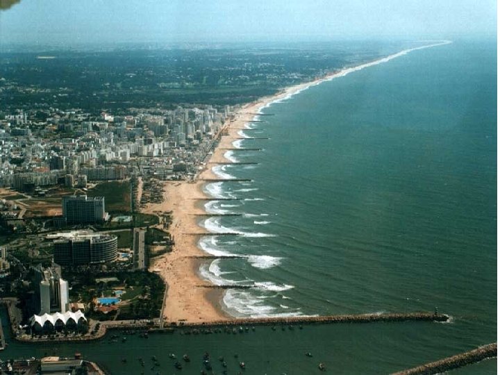


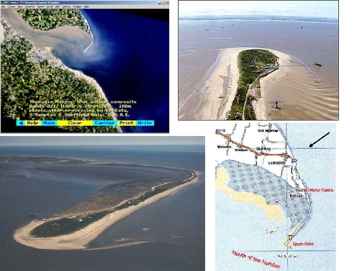
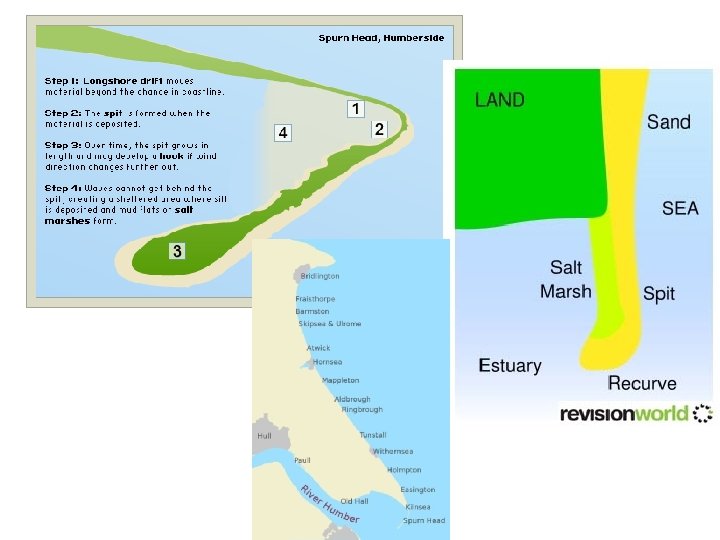
 Example: Spurn Point (Head), Holderness Coastline, East Riding, North-East England.")


- Slides: 49
Transportation along a coastline To know how Longshore Drift (LSD) moves material along a coastline.
What is long-shore drift? • http: //www. youtube. com/watch? v=U 9 Eh. Va 4 Mm. Es&feature=player_embedded
Longshore drift
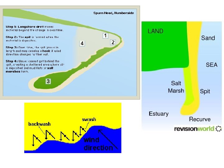
Key terms • Swash: the movement of water up the beach • Backwash: the movement of water back down the beach • Destructive waves: types of waves that remove material from the beach • Constructive waves: types of waves that build up material on the beach • Longshore drift: the movement of beach material along a coastline in a zigzag motion • Prevailing wind: the main direction from which an areas winds come from
Longshore Drift Waves can approach the coast at an ____ because of the direction of the ______. The _______ carries material up the beach at an angle. The ______ then flows back to the sea in a straight line at 90 degrees. Continual swash and backwash _____ material sideways along the coast. This movement of material is called longshore drift and occurs in a _____ motion. In normal conditions more material is _______ on a beach than is removed. However, during storms _______ waves can remove more material than is deposited. To limit the amount of material that is transported along a coastline we can use coastal defences called _______ that trap material on the beach.
Transportation • Waves can approach the coast at an angle because of the direction of the prevailing wind. The swash carries material up the beach at an angle. The backwash then flows back to the sea in a straight line at 90 degrees. This movement of material is called transportation. • Continual swash and backwash transports material sideways along the coast. This movement of material is called longshore drift and occurs in a zigzag motion. • In normal conditions more material is deposited on a beach than is removed. However, during storms destructive waves can remove more material than is deposited. To limit the amount of material that is transported along a coastline we can use coastal defences called groynes that trap material on the beach.
Ms Capper’s answer Describe and explain the process of longshore drift • Longshore drift is a method of coastal transportation and it refers to the movement of sediment along the coastline. • Waves usually approach the coastline at an angle, which is dictated by the direction of the prevailing wind. • The swash (incoming wave) carries sediment up the beach and the backwash then pulls material back to sea at a 90 degree angle, this is due to the force of gravity pulling the water back down the slope of the beach. • Continual swash and backwash transports material sideways along the coast in a zigzag motion. • Constructive waves (in normal conditions) result in more material being deposited than is removed by longshore drift. • Finer particles, such as sand, are transported further along a coastline than heavier material such as shingle.
Self assessment: Give yourself a level
Benefits of Longshore Drift : • Builds up wider beaches at coastal resorts with groynes so more people can use the beach • Provides more beach material further along the coast to help protect coastline from erosion Waves approach at an angle to the shore Beach material is higher on the side of the groyne facing the prevailing wind and waves Beach is wider on the side of the groyne facing the approaching waves Eroded material are found down the coast
Methods of transportation There are four ways that waves and tidal currents transport sediment. These can then contribute to the movement of sediment by longshore drift. • Solution - Minerals are dissolved in sea water and carried in solution. The load is not visible. Load can come from cliffs made from chalk or limestone, and calcium carbonate is carried along in solution. • Suspension - Small particles are carried in water, e. g. silts and clays, which can make the water look cloudy. Currents pick up large amounts of sediment in suspension during a storm, when strong winds generate high energy waves. • Saltation - Load is bounced along the sea bed, e. g. small pieces of shingle or large sand grains. Currents cannot keep the larger and heavier sediment afloat for long periods. • Traction - Pebbles and larger sediment are rolled along the sea bed. Watch: Sticky does coastal erosion Task: Make your own sticky video, showing the 4 methods of coastal transportation
Coasts Beaches, spits and bars
Lesson Objectives • To be able to describe and explain the formation of beaches, spits and bars.
Demonstrate Be READY TO LEARN Think like a Geographer Coastal Deposition It happens when there is lots of erosion elsewhere on the coast, meaning there’s lots of sediment available. There’s lots of transportation of material into the area. LO: To explore the impact erosion, transportation and deposition has on changing coastal environments.
Be READY TO LEARN ACTIVATE Think like a Geographer What is a beach? Beaches are found on coasts between high and low tide level. Beaches are deposits of sand that lies between the high and low tide levels. Most beaches are formed of sand shingle (pebbles) as well as mud and silt. They are mainly found in bays because the waves that enter the bay are constructive waves that have a strong swash and build up the beach. LO: To explore the characteristics and formation of the deposition landforms; beaches.
Be READY TO LEARN Think like a Geographer DEMONSTRATE Pebble Beach Profiles Berms Increasing particle size Smaller sediment particles Large material thrown high onto the beach LO: To explore the characteristics and formation of the deposition landforms; beaches.
What is a beach berm? A berm, is a terrace of a beach that has formed in the backshore, above the water level at high tide. Berms are commonly found on beaches that have fairly coarse sand are the result of the deposition of material by low-energy waves. They have a marked change of slope at their seaward edge and a flat or reverse-sloped platform that lies slightly higher than the mean high-water level. On broad beaches there may be three or more subparallel berms, each formed under different wave conditions. On some beaches a berm several metres wide may be laid down each summer and destroyed each winter by high storm waves.
Be READY TO LEARN DEMONSTRATE Think like a Geographer Sand Beach Profiles LO: To explore the characteristics and formation of the deposition landforms; beaches.
Beach formation • Beaches are made up from eroded material that has been transported from elsewhere and then deposited by the sea. For this to occur, waves must have limited energy, so beaches often form in sheltered areas like bays. • Constructive waves build up beaches as they have a strong swash and a weak backwash. • Sandy beaches are usually found in bays where the water is shallow and the waves have less energy. • Pebble beaches often form where cliffs are being eroded, and where there are higher energy waves. • A cross-profile of a beach is called the beach profile. T • he beach profile has lots of ridges called berms. They show the lines of the high tide and the storm tides. • A sandy beach typically has a gentle sloping profile, whereas a shingle beach can be much steeper. • The size of the material is larger at the top of the beach, due to the highenergy storm waves carrying large sediment. • The smallest material is found nearest the water as the waves break here and break down the rock through attrition.
Be READY TO LEARN Think like a Geographer DEMONSTRATE Study Figure 1, a photograph of a beach. Figure 1 LO: To explore the characteristics and formation of the deposition landforms; beaches.
Be READY TO LEARN DEMONSTRATE Think like a Geographer Study Figure 1, a photograph of a beach. MODEL ANSWER: Beaches are formed when constructive waves deposits load (1) as it loses energy (1). LO: To explore the characteristics and formation of the deposition landforms; beaches.
Spits, bars and tombolos https: //www. youtube. com/watch? v=3 XBq. Eb. Pzgds https: //www. youtube. com/watch? v=Bs-G 57 Ja. Qm 4
Be READY TO LEARN ACTIVATE Think like a Geographer Characteristics of Sandbanks Spit, Dorset Proximal end Distal end Lagoon Mudflats and salt marshes Large hook Spit LO: To explore the characteristics and formation of coastal deposition landforms; spits and bars.
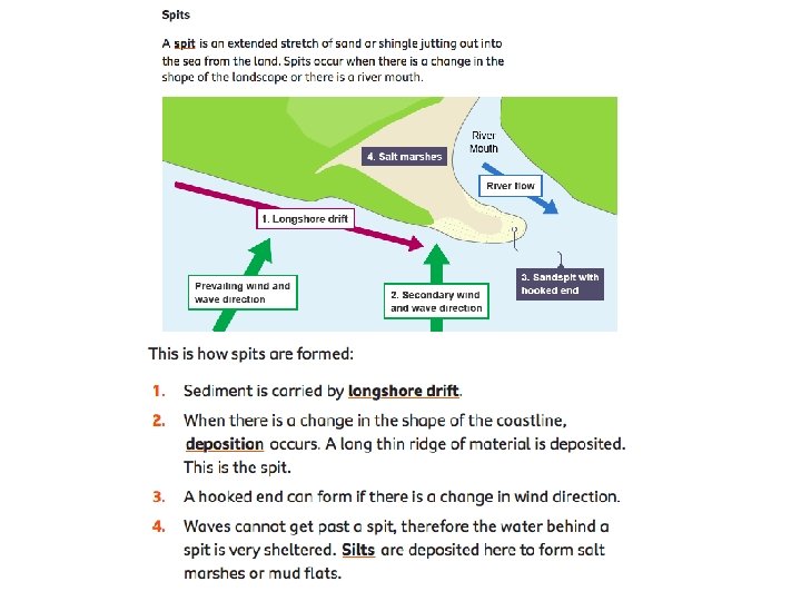
ACTIVATE Be READY TO LEARN Think like a Geographer Formation of a Spit 1. 2. 3. 4. Longshore drift transports sand along the coast. The coastline changes shape and the waves begin to loose energy. Deposition starts to build up at the proximal end and the spit grows out into the sea. The spit is exposed to changes in wind and wave direction which cause the distal end to hook back towards the land. LO: To explore the characteristics and formation of coastal deposition landforms; spits and bars.
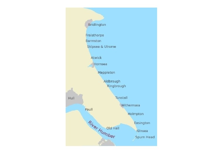
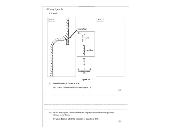
Landform: Spit (deposition) Example: Spurn Point (Head), Holderness Coastline, East Riding, North-East England.
Description • Spurn point is a long narrow ridge of sand shingle, known as a spit. • It is located at the southern most point of the Holderness coastline in East Riding, Yorkshire. • One end of the spit is attached to the land and shingle then extends out into the sea in the direction of the coastline. • Spurn point is over 3 miles long, although in some places it is only 50 metres wide. • It is like a beach that goes out into the sea instead of hugging the land.
Formation • The soft and easily eroded boulder clay, that forms much of Holderness, provides plentiful material for longshore drift. • Prevailing winds approach the Holderness coast from the north-east and move material along the coastline from north to south. This movement is known as longshore drift. • The energy in the waves transporting the material is reduced where the North Sea meets the Humber Estuary. As a result the material is deposited. This process is known as deposition. • As more and more material is deposited it builds upwards and outwards forming a spit (a beach that sticks out to sea). • Waves cannot get behind the spit and this has created a sheltered area where silt is deposited and mud flats have formed.
Eroded material is deposited where the coastline changes direction Groynes have been built here to stop Spurn point being washed away The old lighthouse The second lighthouse The lifeboat crew’s houses Docking facilities The Vessel Traffic Services tower
Management • In the middle of the 19 th century a series of groynes were built on the shore to check the erosion. This was later found to be a bad idea as it stopped the natural movement of the sand around the point, and it also failed to stop the erosion. • There is a policy of managed retreat at Spurn Point today, this is a soft engineering technique and it means that nature is being allowed to take its course. • Human management north of Spurn Point is having an impact though. Groynes that have been built to protect settlements along Holderness e. g. Hornsea and Withernsea reduce the amount of beach material arriving at Spurn Point. The point has already been breached several times in the past and sections of it today are only 50 m wide.
Coasts : Features of Deposition: Spits 12 As cliff and beach material is transported along a coast by longshore drift, if the flow is interrupted or slowed down, the material is deposited to form a range of coastal • A SPIT is unable to extend features. right across an estuary due SPIT: to the force of the river • A linear beach that extends from the shore current finding a route out to across a river estuary or along the coast – but the sea. doesn’t join on to any other feature. • It is RECURVED at the end e. g. Spurn Point, E. Yorkshire in the direction of the strongest of the two currents. • In Spurn Point’s case, the North Sea current is more powerful than the River Humber current, so the spit curves in towards the Possible Questions : estuary. Is this a Describe and explain the SPIT formation of a coastal spit (7) TOMBOLA or BAR ?
Coasts : Features of Deposition / Evolution of Spurn Head, E. Yorkshire – A SPIT 14 A : Sea erodes the coast and Longshore Drift transports material down the coast B : The North Sea and R. Humber currents meet, slow down & deposit their material. The N. Sea current is stronger so the recurved spit bends in to the Humber channel. A Riv er H um b er C urre nt B h ort S r Cu a e t ren C D N E C : As the Spit head grows southwards, erosion still takes place up-coast D : The neck of the spit has more erosion than deposition – so gets thinner E : The sea breaks through the neck, the spit head is an island is eroded away
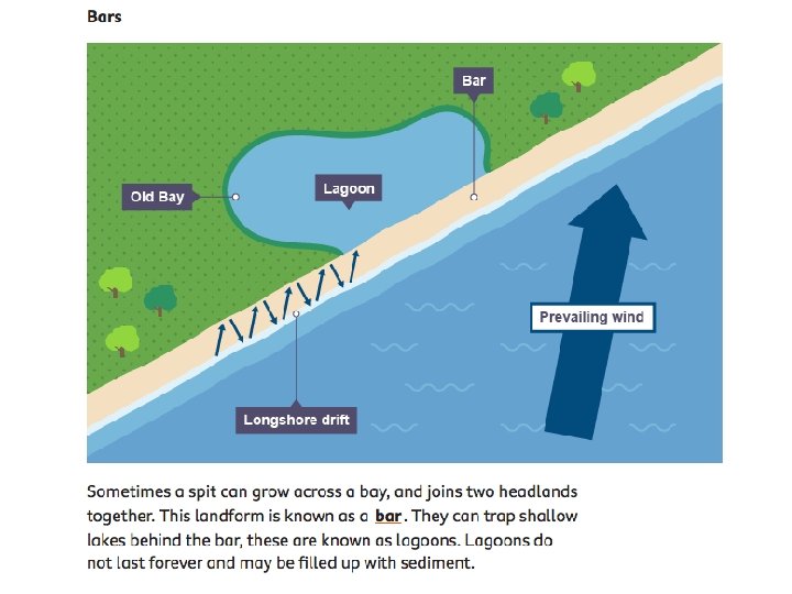
ACTIVATE Be READY TO LEARN Think like a Geographer How is a bar formed? Slapton Ley Bar, Devon, United Kingdom 1. A spit joins together two headlands. 2. A bar cuts off the bay between the headlands from the sea. 3. A lagoon can form behind the bar. LO: To explore the characteristics and formation of coastal deposition landforms; spits and bars.
Be READY TO LEARN Demonstrate Think like a Geographer On your worksheets, label the characteristics of Sandbanks Spit, Dorset. Using the photograph of Slapton Ley Bar, draw a diagram to show a bar. Sandbanks Spit Large hook Lagoon Distal end Slapton Ley Bar Spit Mudflats and salt marshes Proximal end LO: To explore the characteristics and formation of coastal deposition landforms; spits and bars.
ACTIVATE Be READY TO LEARN Think like a Geographer On your worksheet, explain the formation of Spits and Bars. LO: To explore the characteristics and formation of coastal deposition landforms; spits and bars.
Demonstrate Study Figure 2, a graph showing how the width of a beach varied along its length in the years 2010 and 2015. Be READY TO LEARN Think like a Geographer Figure 2 The total volume of material on the beach in Figure 2 increased between 2010 and 2015 because large amounts of material, carried by sea water, were deposited on the coast. (2) Reason 1: ……………. . …………………… Reason 2: …………………… LO: To explore the impact erosion, transportation and deposition has on changing coastal environments.
Demonstrate Study Figure 2, a graph showing how the width of a beach varied along its length in the years 2010 and 2015. Be READY TO LEARN Think like a Geographer Figure 2 The total volume of material on the beach in Figure 2 increased between 2010 and 2015 because large amounts of material, carried by sea water, were deposited on the coast. (2) MODEL ANSWER: There’s lots of erosion elsewhere on the coast, meaning there’s lots of sediment available (1). There’s lots of transportation of material into the area (1). LO: To explore the impact erosion, transportation and deposition has on changing coastal environments.
Coasts : Features of Deposition / Features of the spit at Spurn Head Thin neck o ited s o ep mu lt ( i s er riv 15 f spit each r b ly Like use d) rn Spu Li ho ght u th D he on Spurn Lifeboat st ation cti ire D Recent Deposition here 2 cu bulence w Tur Direction of the River Humber current t of r No et rrents me ac e S nt rre
Things you could include…. . • Direction of longshore drift • Arrows to show swash and backwash • Area of calm water behind spit • Saltmarsh • Vegetation on spit • Hooked end because of wind changes
Coasts : Features of Deposition: Bar Possible Questions What is the difference between a Bar and a Spit? Are these permanent or temporary features of coastal deposition? 13 A BAR is a spit which extends across a bay and reaches the shore on the other side. The water which is cut off becomes a saltwater LAGOON of still water. Eventually, over time the lagoon fills in with windblown sand, sediment, reeds and other vegetation and becomes a marsh. This is SLAPTON LEY in
Tombolo