Towards a Global Statistical Geospatial Framework Martin Brady

Towards a Global Statistical Geospatial Framework Martin Brady Director Geospatial Solutions Section Australian Bureau of Statistics European Forum for Geography and Statistics November 2015
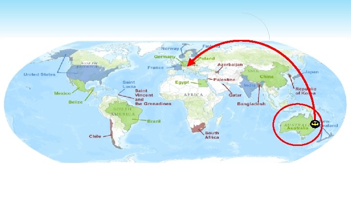


Ø International collaboration Ø Statistical – Geospatial Integration in Australia Ø Global Statistical Geospatial Framework Ø Statistical and geospatial data and metadata interoperability Ø Protecting confidentiality

The challenge ‘The work on global geospatial information management over the past two to three years has confirmed that one of the key challenges is a better integration of geospatial and statistical information as a basis for sound and evidence-based decision-making. ’ Secretary General of the UN Economic and Social Council, 2012.

Geospatial program review Ø Greater collaboration - outreach and information sharing - shared best practice and standards - partnership between statistical and geospatial Ø A common approach to linking statistics to location – a global statistical-geospatial framework Ø Establish an expert group to progress issues Ø Hold a global forum to discuss issues and experiences
 UN Statistical Commission (UNSC) §")
A new partnership UN Economic and Social Council (ECOSOC) UN Statistical Commission (UNSC) § ABS Geospatial program review – proposed a global framework UN Committee of Experts on Global Geospatial Information Management (UN-GGIM) § List of nine issues included 'linking of spatial to statistics' UN Expert Group Statistical-Geospatial Integration UN Global Forum Statistical-Geospatial Integration

United Nations Expert Group on the Integration of Statistical and Geospatial Information

Expert Group - Objectives Ø Coordination and dialogue between statistical and geospatial communities. Ø Propose work plans and guidelines to advance the implementation of a global framework. Ø Address technical, institutional and information policy issues of a global framework. Ø Pursue the implementation of the framework in the 2020 Round of Population Censuses, as well as other censuses and global data initiatives.

The future ‘When both statistical and geospatial information are integrated within a statistical-spatial framework, the geo-statistical results can significantly improve the quality of official statistics and Population Censuses, and the measuring and monitoring of the sustainable development goals. ’ Summary Report of the Global Forum on the Integration of Statistical and Geospatial Information, 2014

Ø Statistical – Geospatial Integration in Australia

Open data Big Data

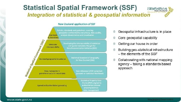
SSF Vision SSF Goals Informed decision making is enhanced by using location in a common framework to allow seamless integration of administrative, statistical and spatial information resources. All statistical data is consistently spatially enabled Users can discover, access, integrate, analyse and visualise statistical information seamlessly for regions of interest

The Framework

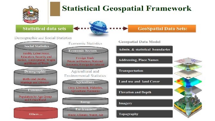
Statistical Community Spatial Community Socio-Economic Datasets Core Statistical Tax Census, Demographics, Agriculture, Building, Labour Force, etc. Income and Business Tax Foundation Spatial Data Framework – Fundamental Elements Admin. & statistical boundaries Addressing, Place Names Health Medicare, Pharmaceuticals, Workforce Social Welfare Unemployment, Disability, Family Support Immigration Land Valuation and Use SSF bridge Transport, Water Land Property Elevation and Depth Imagery Others … Positioning

Population grid – geospatial from statistics

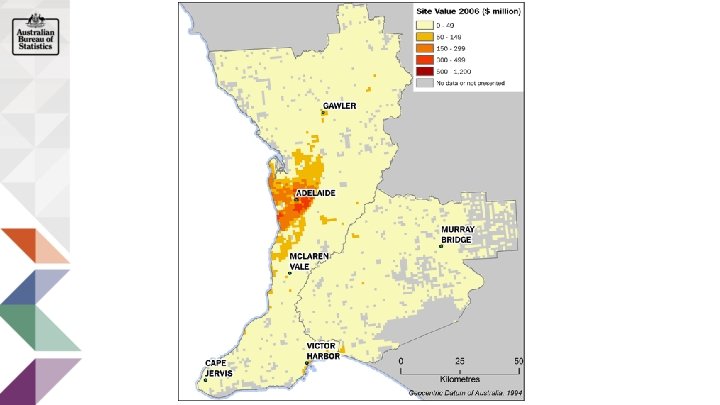
Land Account – statistics from geospatial Geospatial Input State Valuations: • Land use • Land value Irrigated Pasture Statistical Output Geoscience Australia’s Dynamic Land Cover grid Trees open Inland Water Land parcel (Property) Rain-fed Detailed Land Account tables: Land cover by land use, area and value Trees - Small area land account summary data: - Land value - Land cover - Land use - Cadastral change Integrated with other small area data: + Population + Building approvals

Adding Geospatial Information to Statistics Address points from Health Survey - spatial link to built environment data Access to Greenspace Population Density Commuting Distance Access to Health Services

Adding Geospatial Information to Statistics Access to Greenspace Geo-statistics Person Age Sex Body Mass Index Distance to Greenspace 1 F 30 19 0. 25 2 F 28 32 2. 01 3 M 42 27 0. 36

The future… Statistical data linked with spatial data using registers Sample selection or geocoded admin. addresses Statistical dataset Address Register Web Service compares address points and greenspace Greenspace Dataset of address point identifiers with attribute of walking distance to greenspace

Ø Global Statistical Geospatial Framework Ø Statistical and geospatial data and metadata interoperability Ø Protecting confidentiality

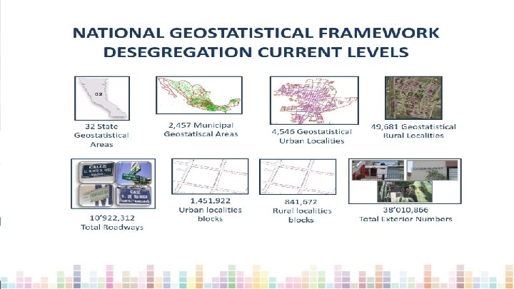
UN Expert Group Global Statistical Geospatial Framework Ø Bring together a proposal adapted from Australian Statistical Spatial Framework Ø Include input from: • Mexico’s National Geostatistical Framework. • EFGS/Eurostat on the GSBPM model for geospatial. • Other country examples of adoption/application.

Global Statistical Geospatial Framework

Next Steps UNSD to: Ø UNSD to undertake consultation – starting Nov 2015 Ø Proposal for adoption in 2016 – UN Statistical Commission – UN-GGIM Committee of Experts

UN Expert Group - Areas for further work Ø 2020 Round of Population Censuses Ø Collaboration and partnership Ø Consistent terminology Ø Protecting confidentiality Ø Interoperable data and metadata between statistical and geospatial domains
 Ø Geography for data")
UN Expert Group - Areas for further work (cont. ) Ø Geography for data release - Administrative, statistical and grid geographies Ø Authoritative geocoding Ø Big data in official statistics and geospatial information

Geospatial and statistical data and metadata interoperability Ø Statistical and geospatial data is not easily transformed and integrated. Ø Too much time is spent preparing and managing data, instead of analysing. Ø Machine to machine is not integrated. Ø UNSD / UN-GGIM establishing a Working Group. – Expert Group and standards organizations

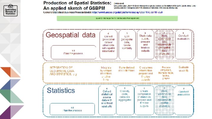
Common Statistical Production Architecture Business Architecture Information Architecture Application Architecture Technology Architecture • General Statistical Business Process Model – GSBPM • General Statistical Information Model • – GSIM • Data Documentation Initiative – DDI • Statistical Data and Metadata Exchange – SDMX • National Statistical Office - NSO Geospatial Data and Metadata
 Ø Open Geospatial Consortium –")
Working Group Ø International Organization of Standardization – (ISO) Ø Open Geospatial Consortium – (OGC) Ø International Hydrographic Organization – (IHO) Ø Statistics Community ? ? - National Statistical Offices - HLG Modernisation Committee on Standards?

Protecting confidentiality for regionalised data Ø “Geographic Differencing” is a specific privacy risk for regionalised data. Ø It is similar to other classification differencing risks, for example occupations. Ø Greater risk due to variety of geographies used within countries.

Geographic differencing Ø Simple geographic differencing – Statistical data for Region 1 is subtracted from Region 2.

Perturbation or controlled rounding – protecting against geographic differencing

Thank you For more information E-mail: geography@abs. gov. au Search: Statistical Spatial Framework
- Slides: 39