Topography Objective Interpret topographic maps TOPOGRAPHY THE STUDY

Topography Objective: Interpret topographic maps.

TOPOGRAPHY THE STUDY OF THE SHAPES AND FEATURES OF THE EARTH’S SURFACE.

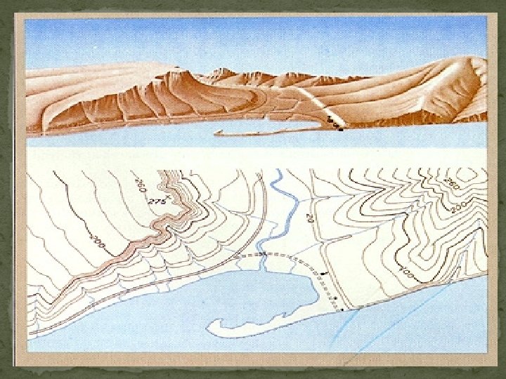
TOPOGRAPHIC MAP SHOWS THE THREE DIMENSIONAL SHAPE AND ELEVATIONS OF AN AREA OF LAND IN TWO DIMENSIONS


ELEVATION HEIGHT ABOVE SEA LEVEL

CONTOUR LINE THAT CONNECTS PLACES ON A TOPOGRAPHIC MAP THAT ARE ALL AT THE SAME ELEVATION (eventually a closed loop) ü Label the contour lines on your map. Contour line
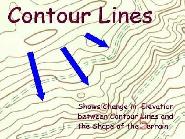

CONTOUR LINE INTERVAL THE VERTICAL DIFFERENCE IN ELEVATION BETWEEN NEIGHBORING CONTOUR LINES contour line interval ü Label the contour line interval on your map.

CONTOUR INTERVALS

INDEX CONTOURS

RELIEF THE DIFFERENCE BETWEEN THE HIGHEST ELEVATION POINT AND THE LOWEST ELEVATION POINT ON A MAP 200 300 400 Units = feet What is the relief of this map? What is the contour interval of this map?

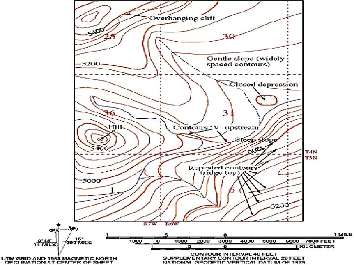
TOPOGRAPHIC MAP RULES v. CONTOUR LINES ARE CLOSELY SPACED ON STEEP SLOPES. v. CONTOUR LINES ARE WIDELY SPACED ON GENTLE SLOPES.

Contour lines LINES CLOSE TOGETHER STEEPER LINES SPACED OUT - < STEEP

Topographic Map Rules WHERE A CONTOUR LINE CROSSES A STREAM OR VALLEY, THE CONTOUR LINE BENDS TO FORM A “V” THAT POINTS UPSTREAM. In the upstream direction, the successive contours represent higher elevations.

OTHER FEATURES

Topographic Map Rules v. CONTOUR LINES NEAR THE TOP OF A HILL FORM CLOSED, CIRCULAR SHAPES. v The top of the hill is higher than the highest closed contour line.

Topographic Map Rules v. DEPRESSIONS WITHOUT OUTLETS ARE SHOWN BY CLOSED HATCHED CONTOURS. The contour lines have short lines on the inside that are pointing down slope. The bottom of the depression is lower than the lowest closed contour line.

DEPRESSION RINGS W/ SHORT LINES POINTING CENTER

Map Rules Contour lines do not cross – height interval changed evenly Index contour = 5 th line 200 WIDE spaced contour lines = GENTLE slope Series of concentric rings = rise in elevation 0 25 DOTTED lines = river CLOSE spaced contour lines = STEEP slope Rings w/ short lines pointing center = DEPRESSION

Satellite Map A MAP MADE OF PICTURES OF THE EARTH TAKEN FROM A SATELLITE ORBITING THE EARTH.

Aral Sea in central Asia
- Slides: 23