Topographic Maps Exactly what you need to know

 • Site name: • • Latitude: 28. 64 °S")


- Slides: 21
Topographic Maps Exactly what you need to know for Test in Week 5 Get out Pink books
BYRON BAY (CAPE BYRON LIGHTHOUSE) • Site name: • • Latitude: 28. 64 °S Longitude: 153. 64 °E • Elevation: 95 m • Most easterly point of the Australian mainland.
What is the definition of relief? • Relief is a general term describing the shape of the land, including height and steepness • Contour lines, colours, shading, spot heights show different patterns of relief
Turn to page 7 of pink book
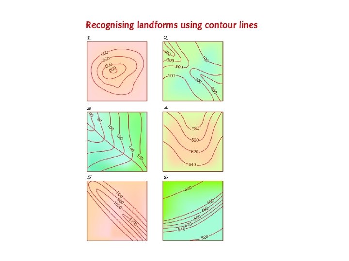
Activity • Match each of the following landform names to the correct contour map: • A cliff • B ridge • C river valley • D round hill • E saddle • F spur.
Geoactive pg 26
Grid references pg 13
Grid References pg 14
Grid References • Turn to Page 13 of pink book
Pg 25 Geoactive
What is the definition of gradient? • Gradient is a measure of slope of the land • Gradient can be classified according to the steepness of the slope • The gradient of an area is the vertical rise of slope over a given horizontal distance.
What is the definition of local relief? • Local relief is the variation in height over a small, defined area.
Aspect • This slope has a NORTH-EAST aspect
Definition of climate • The long-term weather pattern for a place or region
Calculating percentages from a pie graph
Working with photographs- oblique aerial photo Oblique – at a slanting angle
Types of Photos
Types of Photos
Vertical aerial photo