Topographic Maps A map that shows the surface

 features")


 4. Contour lines that cross a valley or")


 be 1410 meters? 2. What is")


- Slides: 48
Topographic Maps • A map that shows the surface features of Earth • Shows the e. LEv. ATion of an area –Height of an object above sea level
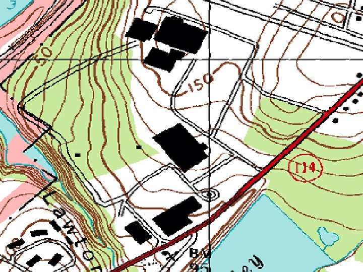
Topographic Map Features • Natural Features –Rivers, lakes –Mountains • Artificial (man made) features –Cities –Roads, bridges
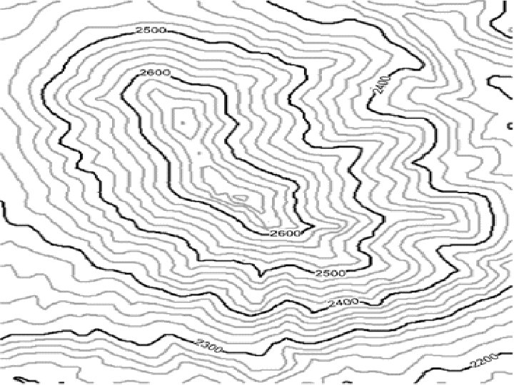
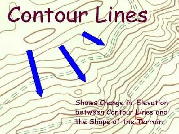
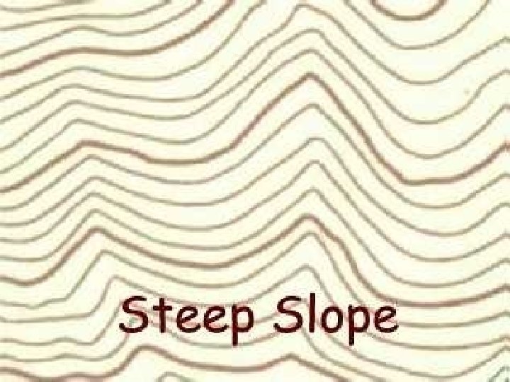
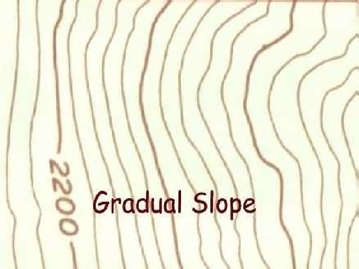
Parts of a Topographic Map 1. Contour Lines • A line that connects points of equal elevation • Used to show features of the land • Spacing of lines depends on slope of land – Close lines = steeper slope – Farther apart = gentle slope
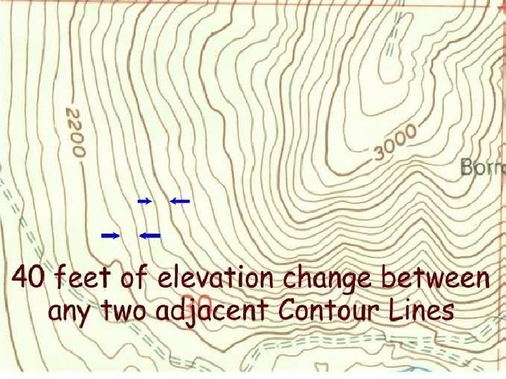
Parts of a Topographic Map 2. Contour Interval The difference in elevation between one contour line to the next • Stays the same throughout a map
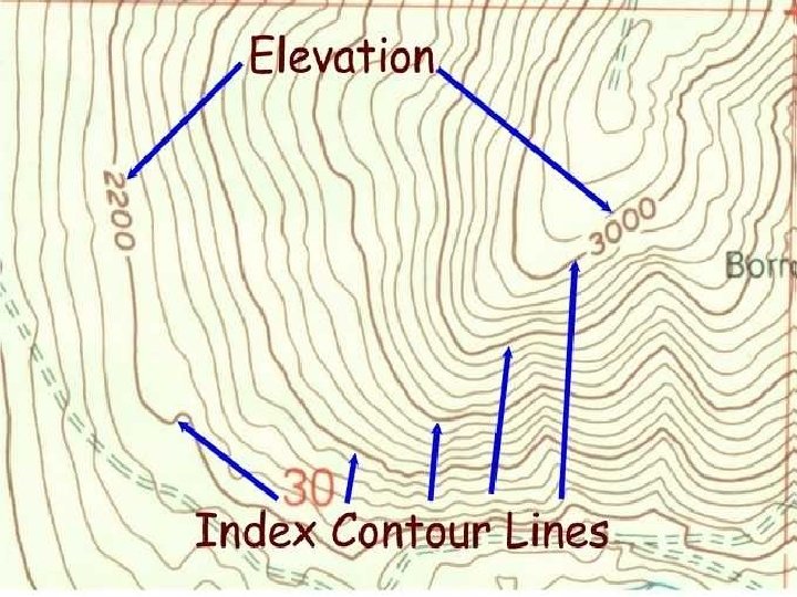
Parts of a Topographic Map 3. Index Contour • A darker, bolder contour line that indicates a change in elevation • Usually found every fifth (5 th) contour line
Reading Topographic Maps • Features on Earth’s surface can be represented by colors –Blue = Water –Brown = contour lines –Green = wooded areas
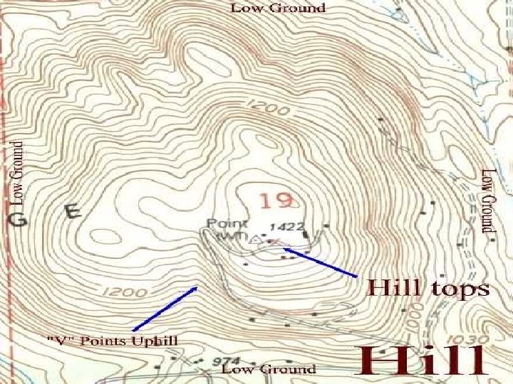
Golden Rules of Topographic Maps 1. Contour lines never cross, all points on a line represent one elevation 2. Spacing of contour lines depends on steepness of slope 3. Tops of mountains or hills are shown by closed circles
Golden Rules of Topographic Maps (continued) 4. Contour lines that cross a valley or stream are V-shaped –The V points towards the area of highest elevation 5. Depressions have hash marks pointing towards the center
Let’s take a walk up a hill!
We’re now at an elevation of 100 meters. 100 m
Let’s keep going! 100 m
Now we’re at 200 m 100 m
Shall we march on? 200 m 100 m
We’ve made it to 300 m! 300 m 200 m 100 m
On to the peak! 300 m 200 m 100 m
We’re on the peak, but what’s our elevation? 300 m 200 m 100 m
Any ideas? Let’s add contour lines for every 50 meters and see if that helps. 300 m 200 m 100 m
We know that we are above 350 m, but less than 400 m. 350 m 300 m 250 m 200 m 150 m 100 m 50 m
Let’s head down the hill, it’s getting late! 350 m 300 m 250 m 200 m 150 m 100 m 50 m
Now what’s our elevation? If you said somewhere between 200 m and 250 m you are right! 350 m 300 m 250 m 200 m 150 m 100 m 50 m
Let’s try this again! 350 m 300 m 250 m 200 m 150 m 100 m 50 m
What’s our elevation now? If you said 50 m or just under, you’re right! 350 m 300 m 250 m 200 m 150 m 100 m 50 m
Let’s now look at the same hill, but the way we might see it from an airplane!
Each color change represents a 50 meter increase.
Now, let’s try the same hike! Our elevation is 0 meters.
Now what is our elevation?
If you said more than 150 meters, but less than 200 meters your right!
Let’s go a little higher.
Think you know our elevation now? More than 300 meters--But less than 350 meters
If we were standing on the peak, what would be our elevation? More than 350 meters, less than 400 meters
Let’s head down hill.
Know our elevation?
More than 100 meters, less than 150 meters
Grab a piece of paper and write your answers to the following questions. Ready?
1. Could the elevation at the peak (B) be 1410 meters? 2. What is the elevation at (E)? 3. What is the elevation difference between (A) & (B)? 4. Could the elevation at (F) be 417 meters? 5. If you walked a straight line from (D) to (C) would you walk over a ridge or down a valley? 6. Just looking at the map, would it be easier to head down from the peak going East, or going North?
E C D B 1200 m F 1000 m A 400 800 m m 600 m
1. No : The elevation must be under 1400 meters, but over 1300 meters. 2. about 400 meters 3. (A) is probably close to the 750 meter line, (B) is above 1300 meters. The difference between the two would probably be 650 to 700 meters. 4. No: It must be more than 700 meters and less than 800 meters. 5. Down a valley: If the contour lines point up the slope it’s a valley, if they point down the slope it’s a ridge. 6. East: When contour lines are close together that means there is a steep slope, the further apart the lines, the more gentile the slope and therefore an easier walk! Go east!