Topic 3 Locating Positions on Earth Global Positioning

Topic 3: Locating Positions on Earth
")
Global Positioning System (GPS)

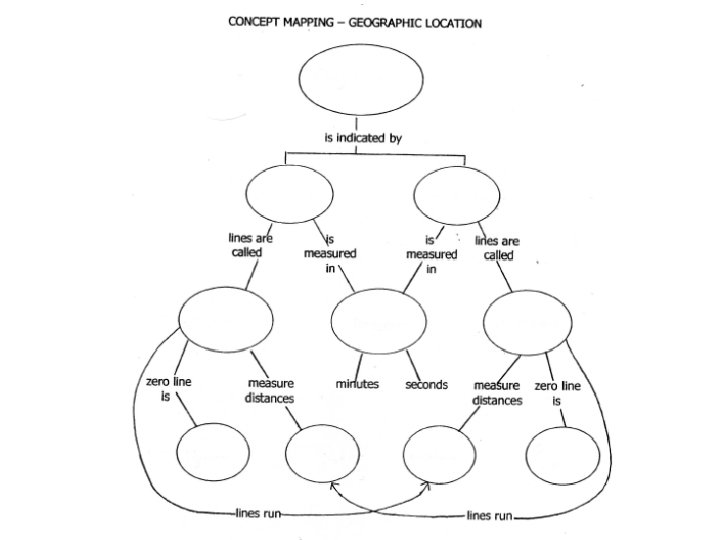
Latitude • Latitude is the angular distance NORTH or SOUTH of the equator. • Lines of latitude form a circle around the earth, and are called PARALLELS. • 0 o to 90 o

Measuring Latitude • The altitude of Polaris in the sky equals an observer’s latitude in the Northern Hemisphere.

This picture of the night sky above Hawaii was taken by leaving the camera shutter open for a long time. The picture captures the apparent movement of the stars caused by Earth's rotation on its axis. Polaris is the star in the center of the star field; it shows essentially no movement. Earth's axis points almost directly to Polaris, so this star is observed to show the least movement. The other stars appear to trace arcs of movement because of Earth's spin on its axis. Photograph by Richard J. Wainscoat http: //www. lpi. usra. edu/education/skytellers/polaris/about. shtml Polaris Animation Polaris in PA

Longitude • Longitude is the angular distance EAST or WEST of the Prime Meridian. • Lines of longitude form semi-circles that connect Earth’s North and South Poles, and are called MERIDIANS. • 0 o to 180 o

0 o 180 o M O N D A Y Prime Meridian International Dateline S U N D A Y

Measuring Longitude EARTH’S ROTATION • Local noon: when the sun is highest in the sky • Earth’s total rotation in 24 hours is 360 o – So in 1 hour, Earth rotates 15 o. • Each degree of latitude or longitude can be further broken down – 1 degree = 60 minutes – 1 minute = 60 seconds
- Slides: 11