Tools to help complete Height Mod Surveys OPUS


- Slides: 23
Tools to help complete “Height Mod” Surveys OPUS & OPUS Projects Joe Evjen, Geodesist, NGS Height Modernization Eastern States Regional Tuesday, March 04, 2014 Webinar
standard geodetic data your GPS data geodesy. noaa. gov/OPUS IGS & NGS base stations & site information files IGS antenna calibrations & satellite orbits & reference frames UNAVCO teqc converter PAGES baseline processor var. geophysical models NGS geodetic toolkit Online Positioning User Service free, fast, easy, consistent coordinates JGE 2013 v 1 mark description your solution options: projects & publishing
Static: OPUS determines your position with a differential GPS static solution, using hours of data. This process is repeated 4 x from other CORS. line se ba e 1 in basel line e as 5 baseline 4 ba se lin e 3 2 b NO BENCH MARKS … is this a height mod survey?
From: opus <opus@ngs. noaa. gov> Subject: OPUS solution : nji 20010. 10 o. txt OP 1377187607298 NGS OPUS SOLUTION REPORT ============. . . SOFTWARE: EPHEMERIS: NAV FILE: ANT NAME: ARP HEIGHT: page 5 1209. 04 master 43. pl 072313 START: 2010/01/01 00: 00 igs 15645. eph [precise] STOP: 2010/01/01 01: 59: 00 brdc 0010. 10 n OBS USED: 5443 / 5579 : 98% 3 S-02 -TSATE NONE # FIXED AMB: 34 / 35 : 97% 1. 000 OVERALL RMS: 0. 010(m) REF FRAME: NAD_83(2011)(EPOCH: 2010. 0000) X: 1319482. 451(m) 0. 002(m) Y: -4656035. 048(m) 0. 004(m) Z: 4140724. 263(m) 0. 005(m) E W EL ORTHO LAT: LON: HGT: OPUS report 40 44 29. 30530 285 49 20. 27369 74 10 39. 72631 16. 818(m) 49. 149(m) IGS 08 (EPOCH: 2010. 0001) 1319481. 685(m) 0. 002(m) -4656033. 603(m) 0. 004(m) 4140724. 204(m) 0. 005(m) 0. 002(m) 40 44 29. 33769 0. 002(m) 285 49 20. 25908 0. 002(m) 74 10 39. 74092 0. 002(m) 0. 006(m) 15. 568(m) 0. 006(m) 0. 016(m) [NAVD 88 (Computed using GEOID 12 A)] UTM COORDINATES UTM (Zone 18) STATE PLANE COORDINATES SPC (2900 NJ ). . .
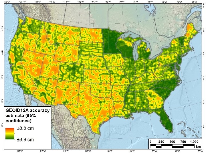
OPUS uses GEOID 12 A to convert ellipsoid height to NAVD 88 How good is it?
DSWorld displays GEOID 12 A accuracy estimates
0. 20 Bad survey? bad marks? bad OPUS? 0. 18 NAVD 88 height accuracy, meters 0. 16 (0. 017 m) NAVD 88 height difference between OPUS and published (0. 055 m) NAVD 88 height accuracy computed from OPUS h + GEOID 12 A (beta tool) 0. 14 (0. 021 m) NAVD 88 height accuracy reported on OPUS solution U H FT 0. 12 0. 10 0. 08 0. 06 0. 04 O E L U R S U P m O c 4 = 1 σ 8 cm = σ 2 : B M 0. 02 0. 00 1, 359 each 4+ hour OPUS solutions on NAVD 88 adjusted bench marks
OPUS-projects: first, run OPUS to harvest all project data OPUS automatically forms sessions from simultaneously observed marks, enabling multi-baseline processing and adjustment of redundant observations. Improved solutions for simultaneous or simple data quality analysis repeated observations harvest data from multiple observers share upload & processing tasks customize your processing using PAGES improve survey accuracy constrain to local networks publishing support (limited)
Why complicate OPUS? Observation CORS 1 HATFIELD 2013 -08 -14 CORS 2 Session CORS 3 OPUS solutions OPUS Projects Adjustment CORS 4 CORS 5 MCCOY 10
Why complicate OPUS? Observation CORS 1 HATFIELD 2013 -08 -14 CORS 2 Session CORS 3 OPUS solutions session 001 OPUS Projects Adjustment CORS 4 CORS 5 MCCOY 11
Why complicate OPUS? Observation CORS 1 HATFIELD CORS 2 Session CORS 3 OPUS solutions session 001 Adjustment CORS 4 CORS 5 MCCOY session 002 session N 2013 -08 -14 OPUS Projects 12
Why complicate OPUS? Observation CORS 1 HATFIELD CORS 2 Session CORS 3 OPUS solutions session 001 Adjustment CORS 4 CORS 5 MCCOY session 002 session N 2013 -08 -14 network adjustment 13
What’s all that really mean for me? OPUS solutions = pretty good, but each treated as independent and assumes “perfect” CORS. Sessions = simultaneously-observed marks processed together in sessions increases consistency. Adjustments = interlinking sessions through network adjustments increases accuracy. 2013 -08 -14 OPUS Projects 14
NGS > OPUS geodesy. noaa. gov/OPUS is the access point for all things OPUS. 2013 -08 -14 OPUS Projects 15
NGS > OPUS > options “Options” allows any user with your project id to add data. 2013 -08 -14 OPUS Projects 16
NGS > OPUS > options > project ID > upload … and a mark description
NGS > OPUS the “Projects” link 2013 -08 -14 OPUS Projects 18
NGS > OPUS > projects … launches the OPUS Projects gateway page. 2013 -08 -14 OPUS Projects 19
Limitations? • Uploads through OPUS-Static. – Dual-frequency. – 2 hrs ≤ data span ≤ 48 hrs (≤ 2 GPS midnights). – Observation interval = a factor of 30 (seconds). • Minimum project size. – None • Maximum project size. – There are practical limits to a project’s maximum size. – About 100 marks in a single session. – Number of data files < a few hundred. 2013 -08 -07 Introduction 20
OPUS Projects Training Because of its increased complexity, training is required to be an OPUS Projects manager. These workshops are usually two day in length and small so that there is ample time for one-on-one interaction with the instructor. Check the NGS training center schedule for upcoming workshops run by NGS. 2013 -08 -14 OPUS Projects 21
Things To Come. OPUS Projects improves because your criticisms and suggestions. Although we can’t act upon every comment, we do appreciate and consider every one. They have and will continue to steered development. Here a few things already in the works: • Allowing data files < 2 hrs in duration. • Better integration with CORS. • Better support for publishing to the NGSIDB. 2013 -08 -07 Introduction 22
User guide in final development