Tohoku Earthquake 2011 Case Study Tohoku Earthquake 2011


- Slides: 25
Tohoku Earthquake 2011 Case Study
Tohoku Earthquake 2011 Primary impacts Key statistics Secondary impacts Location Tectonic setting Key socio-economic data about Japan Moment Magnitude Scale 1 2 3 4 5 6 7 8
The response to the Tohoku Earthquake 2011 linked to the Park Model
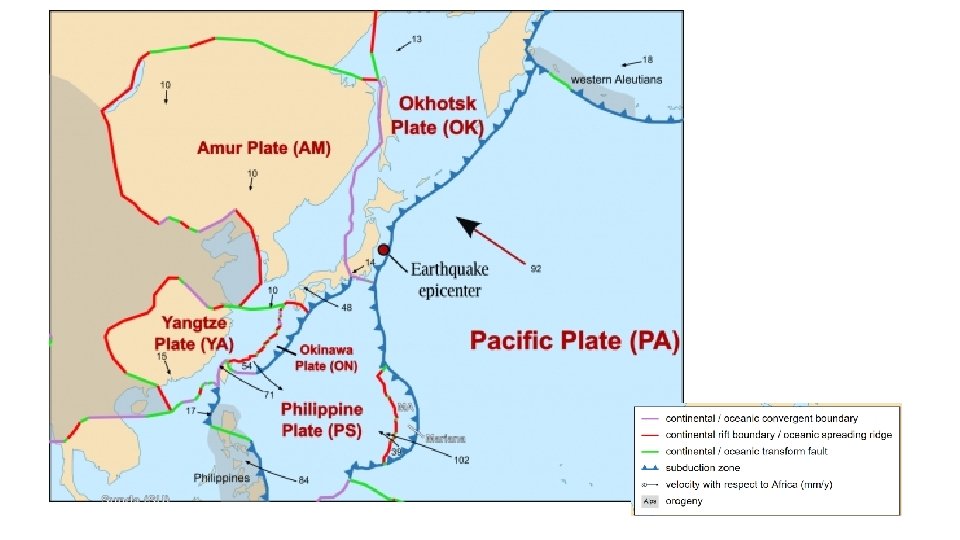
Tectonic setting
Distribution of tsunamis • Destructive plate boundaries where plate movement leads to vertical displacement; Subduction zone related earthquakes generate the majority of all tsunamis • Landslides Associated with the displacement of water • Volcanic eruptions as energy from debris is transferred to water • Meteor Impacts
Earthquake triggered Tsunamis
Seismic sea waves
How deadly? Historic tsunamis: 1450 BC The Santorini supervolcano is believed to have created a massive tsunami affecting the entire Mediterranean and wiping out some civilisations. 7250 BP Storegga slide created a huge submarine debris slide off Norway, producing a tsunami which was more than 6 m high and affected Scotland & other North Sea bordering countries.
• Displaced water mass attempts to find its equilibrium, forming a tsunami. The tsunamis waves move outwards, away from their source and in deep waters can travel unnoticed on the surface at speeds up to 590 mph, crossing an entire ocean in a day or less. • The speed of the tsunami depends on the depth of the ocean basin and as the tsunami waves reach the shallower water, the front of the wave slows down. Then, as the tsunami approaches shore, the waves pile up to create a wave that can rise up to 30 feet before hitting the shore.
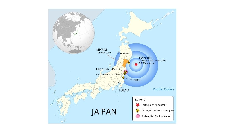
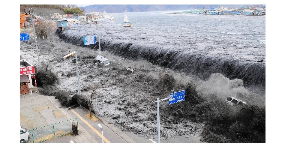
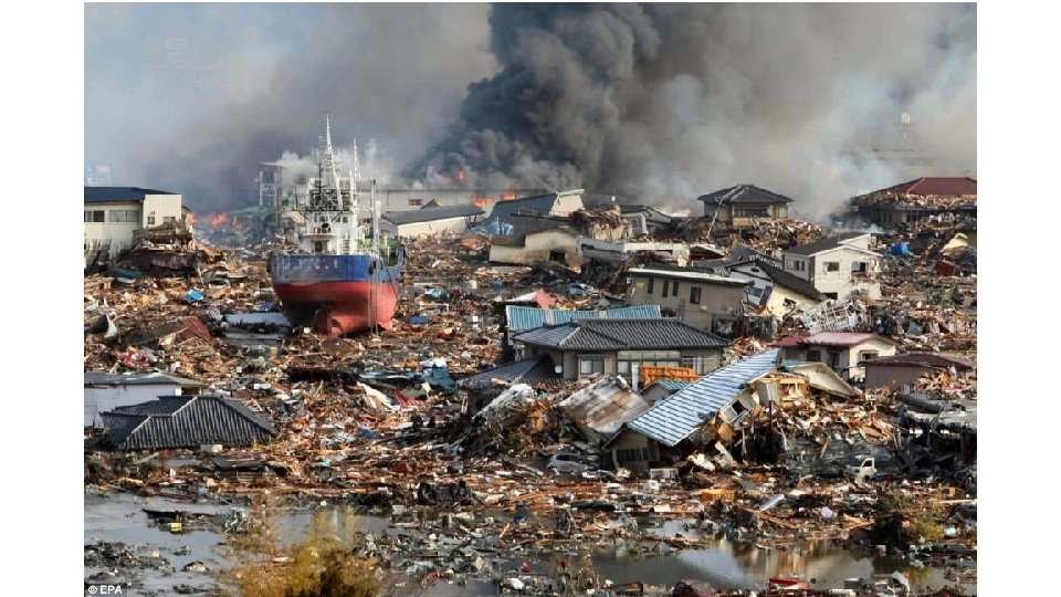
Mar 11, 2011 CE: Tohoku Earthquake and Tsunami On March 11, 2011, Japan experienced the strongest earthquake in its recorded history. The earthquake struck below the North Pacific Ocean, 130 kilometers (81 miles) east of Sendai, the largest city in the Tohoku region, a northern part of the island of Honshu. The Tohoku earthquake caused a tsunami. A tsunami—Japanese for “harbor wave”—is a series of powerful waves caused by the displacement of a large body of water. Most tsunamis, like the one that formed off Tohoku, are triggered by underwater tectonic activity, such as earthquakes and volcanic eruptions. The Tohoku tsunami produced waves up to 40 meters (132 feet) high, More than 450, 000 people became homeless as a result of the tsunami. More than 15, 500 people died. The tsunami also severely crippled the infrastructure of the country. In addition to the thousands of destroyed homes, businesses, roads, and railways, the tsunami caused the meltdown of three nuclear reactors at the Fukushima Daiichi Nuclear Power Plant. The Fukushima nuclear disaster released toxic, radioactive materials into the environment and forced thousands of people to evacuate their homes and businesses.
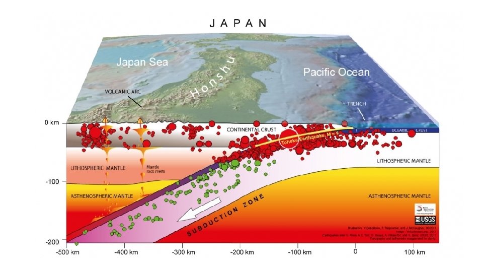
Tectonic Summary The March 11, 2011, M 9. 1 Tohoku earthquake, which occurred near the northeast coast of Honshu, Japan, resulted from shallow thrust faulting on the subduction zone plate boundary between the Pacific and North America plates. At the location of this earthquake, the Pacific plate moves roughly westward relative to the North America plate at a velocity of 83 mm/yr, and begins its westward descent beneath Japan at the Japan Trench, east of the March 11 th earthquake. Note that some authors divide this region into several microplates that together define the relative motions between the larger Pacific, North America and Eurasia plates; these include the Okhotsk and Amur microplates that are part of North America and Eurasia, respectively. The location, depth (about 25 km), and focal mechanism solutions of the March 11 th earthquake are consistent with the event having occurred on the subduction zone plate boundary. Modeling of the rupture of this earthquake indicates that the fault moved as much as 50– 60 m, and slipped over an area approximately 400 km long (along strike) by 150 km wide (in the down-dip direction). The rupture zone is roughly centered on the earthquake epicenter along strike, while peak slips were up -dip of the hypocenter, towards the Japan Trench axis. The March 11 th earthquake was preceded by a series of large foreshocks over the previous 2 days, beginning on March 9 with a M 7. 4 event approximately 40 km from the epicenter of the March 11 th earthquake, and continuing with another three earthquakes greater than M 6 on the same day. The Japan Trench subduction zone has hosted nine events of M 7+ since 1973. The largest of these, a M 7. 8 earthquake approximately 260 km to the north of the March 11 th epicenter, caused 3 fatalities and almost 700 injuries in December 1994. In June 1978, a M 7. 7 earthquake 35 km to the southwest of the March 11 th epicenter caused 22 fatalities and more than 400 injuries. Large offshore earthquakes have occurred in the same subduction zone in 1611, 1896, and 1933 that each produced devastating tsunami waves on the Sanriku Coast of Pacific northeast Japan. That coastline is particularly vulnerable to tsunami waves because it has many deep coastal embayments that amplify tsunami waves and cause great wave inundations. The M 7. 6 subduction earthquake of 1896 created tsunami waves as high 38 m and caused 27, 000 fatalities. The M 8. 6 earthquake of March 2, 1933, produced tsunami waves as high as 29 m on the Sanriku Coast and caused more than 3, 000 fatalities. Unlike the recent M 9. 0 earthquake, the 1933 earthquake did not occur as the result of thrust faulting on the subduction zone plate interface, but rather within the Pacific plate just seaward of the Japan Trench. The March 11, 2011, earthquake was much larger than other post-1900 plate boundary thrust fault earthquakes in the southern Japan Trench, none of which attained M 8. A similarly sized predecessor may have occurred on July 13, 869, when the Sendai area was swept by a large tsunami that Japanese scientists have identified from written records and a sand sheet. Continuing readjustments of stress and related aftershocks are expected in the region of this earthquake. The exact location and timing of future aftershocks cannot be specified. Numbers of aftershocks will continue to be highest on and near to fault-segments on which rupture occurred at the time of the mainshock. The frequency of aftershocks will tend to decrease with elapsed time from the time of the mainshock, but the general decrease of activity may be punctuated by episodes of higher aftershock activity. Beyond the ongoing aftershock sequence, the earthquakes in Japan have not significantly raised the probability of future major earthquakes. While the probability of future large earthquakes far from northern Honshu has not increased, neither has it decreased; large global earthquakes will likely continue to occur just as we have observed in the past.
Impacts • • • At least 15, 703 people killed, 4, 647 missing, 5, 314 injured, 130, 927 displaced At least 332, 395 buildings, 2, 126 roads, 56 bridges and 26 railways destroyed or damaged by the earthquake and tsunami along the entire east coast of Honshu from Chiba to Aomori. The majority of casualties and damage occurred in Iwate, Miyagi and Fukushima from a Pacific-wide tsunami with a maximum runup height of 37. 88 m at Miyako. • The total economic loss in Japan was estimated at 309 billion US dollars. • Electricity, gas and water supplies, telecommunications and railway service disrupted and several reactors severely damaged at a nuclear power plant near Okuma. • Several fires occurred in Chiba and Miyagi. • At least 1, 800 houses destroyed when a dam failed in Fukushima. • Maximum acceleration of 2. 93 g recorded at Tsukidate. Horizontal displacement and subsidence observed. • Landslides occurred in Miyagi. • Liquefaction observed at Chiba, Odaiba, Tokyo and Urayasu. • The tsunami destroyed or severely damaged many coastal towns in the Kuji-Minamisanriku-Nami area.
Global impacts • One person killed and several houses destroyed at Jayapura, Indonesia by a tsunami with a wave height of 2 m. • One person killed south of Crescent City, California and several boats and docks destroyed or damaged at Crescent City by a tsunami with a recorded wave height of 247 cm. • Several houses, boats and docks destroyed or damaged at Santa Cruz, California; Brookings, Oregon; Hale`iwa, Kailua Kona and Kealakekua, Hawaii. • Some buildings damaged slightly in the Galapagos Islands, Ecuador by a tsunami with a recorded wave height of 208 cm at Santa Cruz. • Several houses destroyed at Pisco, Peru. • Felt (VIII) at Fukushima, (VII) at Agui, Hiratsuka, Kiryu, Komae, Oyama, Sendai and Tsukuba and (VI) in much of eastern Honshu, including the Tokyo-Yokohama area, Japan. Felt from Hokkaido to Kyushu. Recorded (7 JMA) in Miyagi. Felt in Northern Mariana Islands, North Korea, South Korea, Taiwan, northeastern China and southeastern Russia as far as Kaohsiung, Beijing and Petropavlovsk-Kamchatskiy. • Seiches observed at Leikanger, Norway. Water fluctuations observed in a well in Newfoundland, Canada. • The tsunami had maximum runup heights of 29. 6 m at Ofunato, 18. 4 m at Onagawa and 9. 4 m at Iwaki. Wave heights in centimeters (above sea level) were recorded at the following selected tide gauges: 250 at Arica, Chile; 282 at Hanasaki and 157 at Omaezaki, Japan; 163 at Manzanillo, Mexico; 156 on Midway Island; 97 on Chatham Island, New Zealand; 109 at Manus, Papua New Guinea; 173 at Callao, Peru; 250 at Kahului, Hawaii, USA; 202 at Port Orford, Oregon; 157 at Shemya, Alaska. • The tsunami also caused some massive slabs of ice to calve from the Sulzberger Ice Shelf, Antarctica. • New Guinea; 173 at Callao, Peru; 250 at Kahului, Hawaii, USA; 202 at Port Orford, Oregon; 157 at Shemya, Alaska. The tsunami also caused some massive slabs of ice to calve from the Sulzberger Ice Shelf, Antarctica
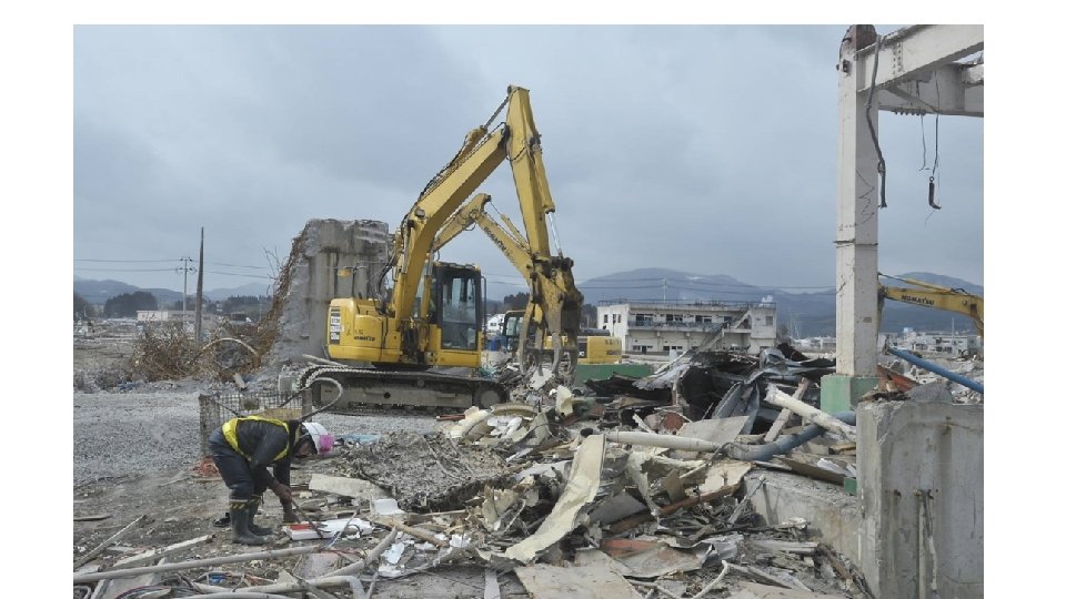
• Nine years have passed since the occurrence of the 2011 Tohoku earthquake in Japan. Taiwan Red Cross (TRC) has been continuing the recovery and reconstruction works for the areas heavily-hit by the strong earthquake and tsunami. According to the 29 th Progress Report delivered by Japanese Red Cross Society (JRCS), the construction of 656 public housing units in Otsuchi, Iwate Prefecture was completed in November 2019. The six large reconstruction hardware and related software efforts by TRC in the three heavily-hit areas of Fukushima, Miyagi, and Iwate have reached a successful conclusion as Otsuchi celebrated its 130 th anniversary on 2 February 2020. • Of the 656 public housing units built after the 2011 Tohoku earthquake, 463 units were supported by the fund contributed by TRC, and the remaining 193 units were supported and constructed by the government of Iwate Prefecture. Otsuchi is responsible for the management of the entire 656 public housing units. Otsuchi located in a remote area in the northeast part. They faced a huge financial difficulty after hit by the disaster. Therefore, TRC signed a memorandum of cooperation with JRCS, covering 85% of the reconstruction costs. A total of 656 public housing units was completed and ready for move in last November. • With a focus on the heavily-hit remote areas, the recovery project supports public reconstruction, include building public housing units for seniors, kindergartens, afterschool facilities, community hospital, and a community activity center that can be transformed into an emergency shelter in times of natural disaster or any other emergency. • TRC contributed 2. 22 billion JPY towards the reconstruction of the project supported community hospital – Minamisanriku Town Hospital in Miyagi Prefecture. The reconstruction was completed on 15 November 2015. Minamisanriku Town Hospital is three stories high with an area of 7, 300 square meter. The site was elevated to protect patients and staff from tsunami. Boasting 1 operating room and 11 clinics with 90 beds, the institution can service 50, 000 outpatients and 31, 000 inpatients each year. They have 9 departments, include Internal Medicine, Surgery, Plastic Surgery, Pediatrics, Ophthalmology, Urology, Otorhinolaryngology, Dermatology, and Oral Surgery. The hospital is also equipped with advanced screening technology such as CT scanning machines. • TRC launched an emergency appeal for the 2011 Tohoku earthquake right after the disaster occurred. As of December 2019, the project raised donations, inclusive of interest, in the amount of NTD 2, 577, 784, 675. Expenditures have amounted to NTD 2, 577, 311, 441, making for a fund implementation rate of 99. 98%.
Responses resources • Five years since Fukashima BBC report • The Road to Recovery and Reconstruction from the Great East Japan Earthquake • World Vision resource with response timeline World Vision is an NGO, a global Christian humanitarian organization. We partner with children, families, and their communities to reach their full potential by tackling the causes of poverty and injustice.
Tohoku Earthquake 2011 Primary impacts Key statistics Secondary impacts Location Tectonic setting Key socio-economic data about Japan Moment Magnitude Scale 1 2 3 4 5 6 7 8
The response to the Tohoku Earthquake 2011 linked to the Park Model
Hazard Management • Why can't we predict when earthquakes will happen Iain Stewart