Tides Oceanography What is a Tide A change


- Slides: 19
Tides Oceanography
What is a Tide? • A change in the ocean water level • Typically reaching a high and low level twice daily (about 6 hours apart)
Types of Tides • Flood tide – change from low to high tide • Ebb tide – change from high tide to low tide
Cause of tides • Gravity • Creates a bulge in the ocean water almost inline with the position of the moon. – One toward the moon – One on opposite side of the earth, away from the moon
Different Tides • Diurnal tide – location experiences one high and low tide daily • Semi-diurnal tide – location experiences two high and low tides daily • Mixed tides – experience two unequal high tides and two unequal low tides per tidal day
Factors Affecting Tides • Shapes of shorelines • Depth of water • Orbit of the moon around earth – Ellipse – Closest point (called perigee) about every 28 days • Orbit of earth around the sun – Ellipse
Neap Tide • Seven days after the full moon and new moon • Earth, moon and sun are at right angles • Causes smallest range between high and low tide
Spring Tide • When all the earth, moon and sun are inline • Moon and sun’s pull on the Earth’s water is at its greatest • Causes greatest ranges between high and low tide
The ability for the ocean to absorb and store energy from the sun is due to… • The transparency of the water that allows the sun’s ray to penetrate deep into the ocean. • Constant turbulence from wind and weather mixes the water, distributing surface hearting throughout
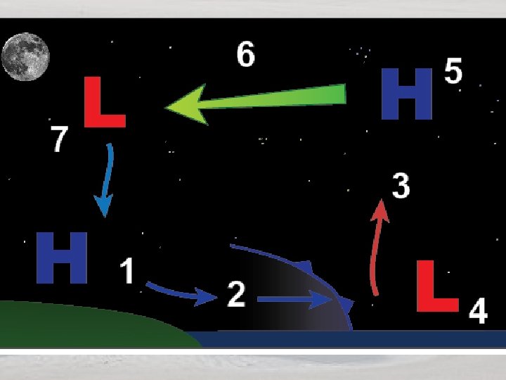
Sea Breeze Circulation • Composed of two opposing flows – One at the surface (called sea breeze) – One aloft (a return flow) • Two flows are a result of the difference in air density between the land sea caused by the sun’s heating.
Air begins to cool Density differences causes air to flow back over water Air cools, density increases, sinks toward Earth. Less dense air rises. Enhanced high pressure near ocean’s surface. Thermal Low Cooler, more dense air spreads inland
Steps of Sea Breeze 1. Sun warms ground and ocean, ground’s heat radiates into atmosphere, warming air. As air warms, density decreases creating a weak low pressure area called a “thermal low” 2. The cooler, more dense air from water, spreads inland. 3. Air from ocean undercuts less dense air over land forcing it to rise. -Sea breeze front - develops due to the large difference between the air temperature over land over water 4. Air begins to cool, density increases, forms small area of high pressure (Occurs from 3, 000 to 5, 000 feet in elevation. ) 5. High pressure/density air flows back over water (where there is low air pressure/density) 6. Air cools, density increases, air sinks toward the earth’s surface 7. Enhances high pressure near the ocean’s surface.
Land Breeze 1. Land temperature falls below ocean temperature resulting in increase in air’s density. Gravity’s pulls dense air offshore. 2. More dense air undercuts the lighter, warmer air over water. 3. Forces air up into the atmosphere 4. Raising air from a weak low pressure area. 5. Rising air accumulates aloft forming an area of higher pressure 6. Air flows back toward land from high pressure to low pressure 7. Air cools, increases in density, then sinks causing an increase in density and high pressure.
Land Breezes Weaker than Sea Breeze • At night: – Cooling ground inhibits vertical motion which weakens the land breeze circulation – Nighttime cooling produces a shallower change in temperature so land breeze circulation is shallower – Terrain, vegetation, and buildings inhibit the flow of air from land to water.
Marine Layer • Represents a difference between a cool, moist airmass and a warmer airmass. • Can persists for days and weeks along the west coast, particularly Southern California. • Depth depends on the large scale weather patterns that pass overhead
Marine Layer and High Pressure System • High pressure systems tend to squish the marine layer down near the surface • Coastal clouds and foggy weather is confined to beaches with warm, sunny conditions beginning a mile or so inland.
As high pressure decreases in strength • Downward force decreases allowing marine layer to penetrate farther inland • Flog lifts at the beach to a lower cloud deck • Further inland, fog is located at the leading edge of the inland push of the cooler air.
Marine Layer and Low Pressure System • Marine layer is allowed to deepen as much as 6, 000 feet • Fog is confined to mountain tops and passes • Air begins to warm at lower elevations as it is modified by the heat rising from the ground. • Cooler air moves over coastal mountains and through the passes into the interior valleys.