This Photo by Unknown Author is licensed under

This Photo by Unknown Author is licensed under CC BY-SA GOES-R Geostationary Satellites and their use in fire detection

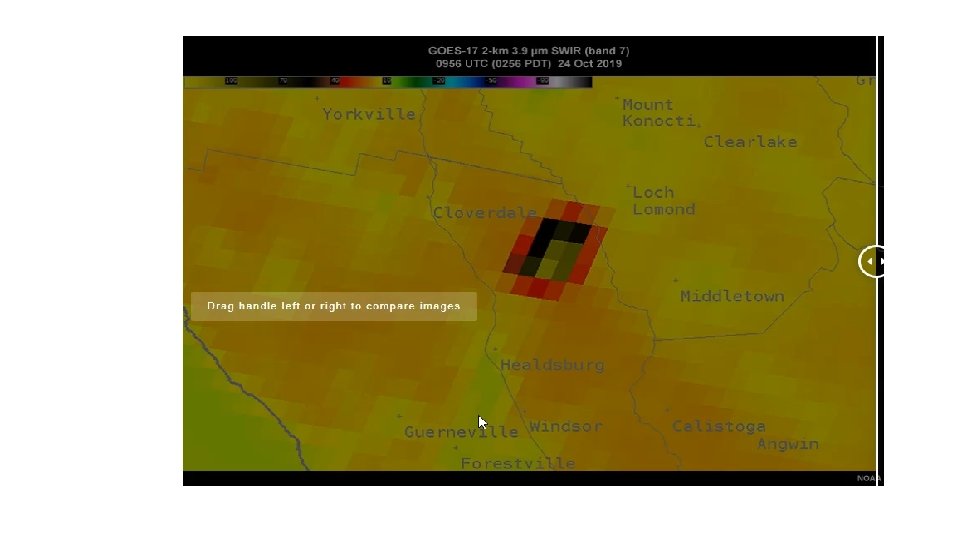
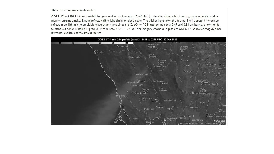
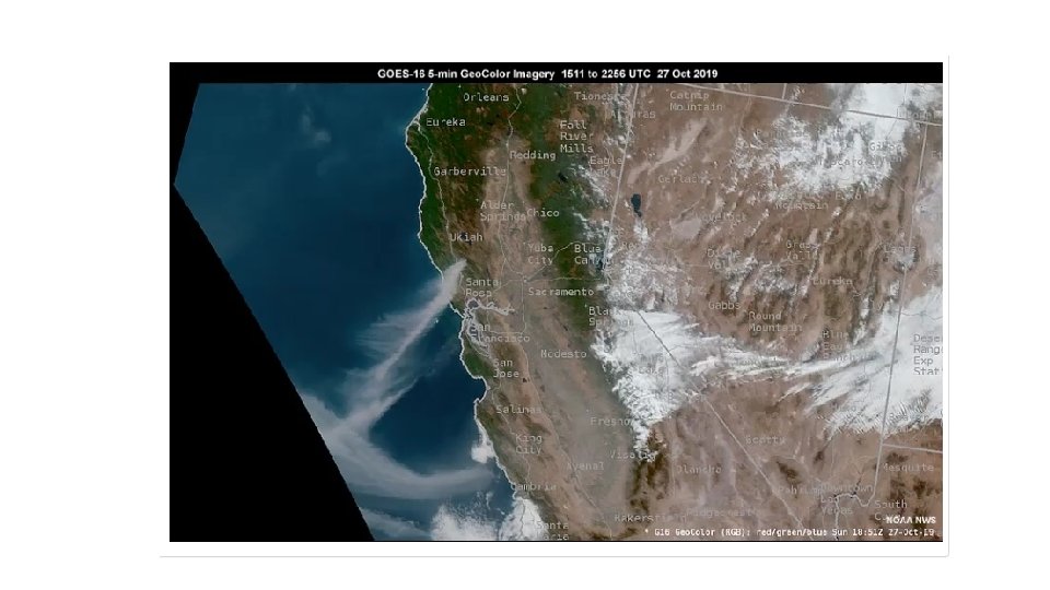
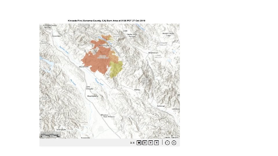
In the fall of 2019 a number of high profile and rapidly spreading fires ignited throughout California. The largest, the Kincade fire, was active from 23 October to 6 November in Sonoma County. The fire burned nearly 78, 000 acres and damaged or destroyed over 400 structures.

Early history 1966 – Weather Movies Spinning visible camera recorded weather movies. Positive feedback led to the addition of infrared to provide nighttime as well as daylight coverage. This Photo by Unknown Author is licensed under CC BY-NC-ND This Photo by Unknown Author is licensed under CC BY-SA

Satellites and Instruments today for trace wildfires polar orbiters : • NASA's Terra and Aqua satellites • NASA-NOAA's Suomi NPP satellite provide detailed views of fires and smoke globally up to twice a day

geostationary platforms
 • Sounding is added to the visual and infrared")
1980 – GOES 4 (VISSR) • Sounding is added to the visual and infrared capability of the satellite. • Atmospheric temperature and moisture profiles improve. • Sounding channels between carbon monoxide and water vapor band. • Cloud detection (visible channel) • Horizontal temperature and moisture track convection. • Vertical resolution remains limited.

ABBA, 1990’s – Better, Stronger, Faster sensor • Faster coverage, Higher resolution, More bands, Improved SNR • Automated Biomass Burning Algorithm (ABBA) • GOES 7, GOES 8 – Wildfire ABBA (WFABBA) 2002 This Photo by Unknown Author is licensed under CC BY-SA
 2002")
Wildfire ABBA (WFABBA) 2002
 2002")
Wildfire ABBA (WFABBA) 2002
 4 X higher")
GEOS- R • • • 3 X more channels (16 channel) 4 X higher resolution – 2 km 5 X faster scan rate – 30 s to 1 min 2019 Q 2 – GOES R & JPSS Joint Polar Sat System PG&E leverages data from 5 satelites Accesses a data stream of 1 min intervals PG&E algorithm monitors detections Links to local weather data and generates email alerts

• GEOS-R also called GEOS-16 • The Geostationary Operational Environmental Satellite – R Series • -3 rd Generation Series • launched on November 19, 2016 (23: 42: 00 UTC) , 105º W longitude 35, 786 km, above the equator

Specification:
: smoke Bands • SWIR band (1. 6 µm): smoke")
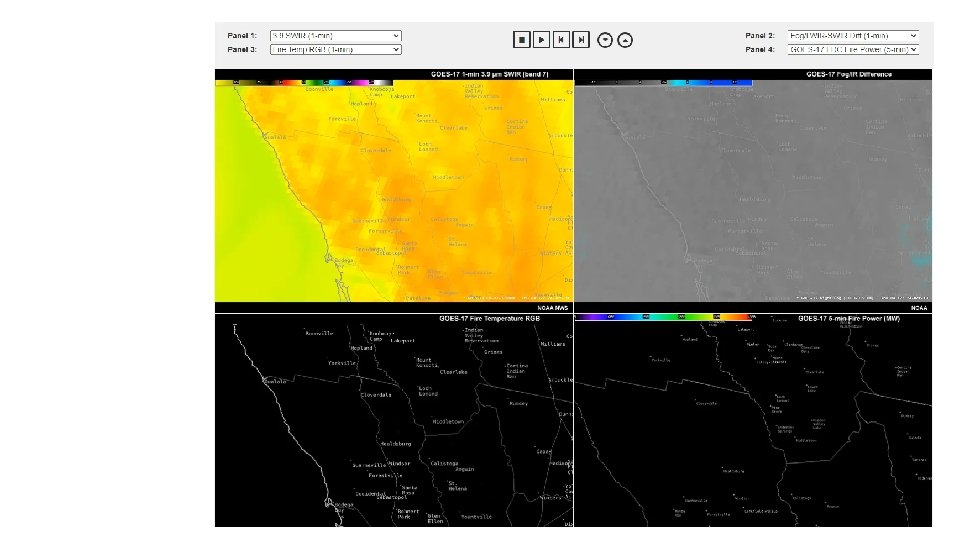
VIS band (0. 64 µm): smoke Bands • SWIR band (1. 6 µm): smoke from low-burn-rate fires resolution 1. 0 Km • MWIR band (3. 9 µm): fire identification resolution 2. 0 Km • MWIR band (7. 0 µm): • TIR band (11. 2 µm): • TIR band (12. 3 µm): • TIR band (13. 3 µm): • VIS band (0. 47 µm): • VIS band (0. 86 µm): This band provides synergy with AVHRR/3 band The band is used for determining vegetation amount, aerosols and ocean/land studies. • SWIR band (1. 378 µm): • TIR band (8. 5 µm): • TIR band (10. 3 µm):

Tech approach

Data Processing Base on Reflectance OLCI true color reconstruction process: ρ = Rrs π. Rrs: remotely-sensed reflectance, water-leaving reflectance X, Y, and Z (red, green, and blue) Δλ = 1 nm, 400– 700 nm ρw : surface reflectance The three tristimulus functions (XCIE, YCIE, and ZCIE) begin at 360 and extend to 780 nm, D 65 term is the standard illuminant for daylight, OLCI reflectance data
")
Base parameter ρ( reflectance)

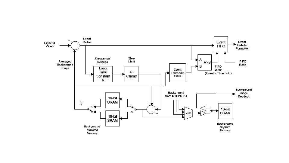
Scan model interpreter Full disk: Defined as a 17. 4 degree diameter circle centered at nadir. CONUS (Contiguous U. S. ): Defined as a 3000 km (NS) x 5000 km (EW) rectangle. Meso: Defined as a square 1000 x 1000 km area (at the satellite subpoint Simplified Functional Block Diagram of RTEP Event Detection Logic:

Result:

Sources 1. PG&E Fire-Detection Satellite Map, www. pge. com/en_US/safety/emergencypreparedness/natural-disaster/wildfires/fire-detectionsatellite-map. page. 2. Williams, David. “New Radar Helps Scientists See inside Wildfires and Fits on the Back of a Truck. ” CNN, Cable News Network, 4 Nov. 2019, www. cnn. com/2019/11/04/us/wildfire-radar-trnd/index. html. 3. Stone, Maddie The Washington Post. “Experimental Radar Is Being Used to Peer Beneath The Smoke of The California Fires. ” Science. Alert, 4 Nov. 2019, www. sciencealert. com/this-new-radar-could-help-scientistspredict-the-spread-of-deadly-wildfires#. 4. “GOES Early Fire Detection (GOES-EFD) System. ” CSTARS D 3 Science, www. cstarsd 3 s. ucdavis. edu/systems/goes-efd. Accessed 9 Nov. 2020. 5. “GOES Early Fire Detection (GOES-EFD) System. ” CSTARS D 3 Science, www. cstarsd 3 s. ucdavis. edu/systems/goes-efd. Accessed 9 Nov. 2020. 6. “GOES-16: A Game-Changer for Fighting Deadly Wildfires. ” www. goes-r. gov/feature. Stories/goes 16 Wildfires. html. Accessed 9 Nov. 2020.
- Slides: 27