THINKING GEOGRAPHICALLY Chapter 1 Map Scale 3 types


- Slides: 15
THINKING GEOGRAPHICALLY Chapter 1
Map Scale • 3 types of scale: • Fractional/Ratio-1/24, 000 or 1: 24, 000 means 1 inch on the map represents 24, 000 inches on the ground • Written: 1 inch equals one mile • Bar - • Scale examples • Neighborhood maps, world maps, country maps all have different scales • The scale is determined by the amount of detail shown in a map • Neighborhood maps will have the largest scale, World maps have the smallest scale
Scale Differences: Maps of Florida
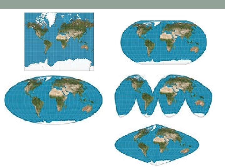
Projection • Since the earth is a 3 D object and a map is a 2 D object, maps will have distortions • This leads to distortion • Shape, distance, relative size, direction • Types of projections • Robinson, Mercator, Mollweide, Sinusoidal, Goode homolosine, • Robinson is best to show size of the oceans • Mercator has least distortion in shape and direction. Grossly distorted near poles
How Geographers Address Location • Contemporary Tools • GIS- layered data to show patterns and relationships (Ian Mc. Harg) • Remote sensing- Satellites that record and map the Earth (mostly environmental but helps with monitoring urban sprawl) • GPS- Precise location provided by satellites (navigation)
Uniqueness of Places and Regions • Place: Unique location of a feature • Place names- Lakeland (toponym). Can be named for several reasons • Site- physical character like climate, water, soil, vegetation. • Situation-location to other places. Singapore is a good example. • Mathematical location- GPS coordinates • Greenwich, England • Latitude and longitude provide location • Latitudes are calculated by the sun whereas longitudes are man made • East of international dateline-ahead • West of international dateline-behind
World Geographic Grid Fig. 1 -8: The world geographic grid consists of meridians of longitude and parallels of latitude. The prime meridan (0º) passes through Greenwich, England.
World Time Zones Fig. 1 -9: The world’s 24 standard time zones are often depicted using the Mercator projection.
Uniqueness of Places and Regions • Regions: Areas of unique characteristics • Cultural landscape- regions have distinct characteristics because of social and physical processes and the Earth is shaped by these relationships. • Types of regions- Vernacular, Formal and Functional • Regional integration of culture -Care about/care for help explain why places on the Earth are unique • Cultural ecology-Culture effects the environment • Possibilism versus Environmental determinism
Formal and Functional Regions Fig. 1 -11: The state of Iowa is an example of a formal region; the areas of influence of various television stations are examples of functional regions.
Vernacular Regions Fig. 1 -12: A number of factors are often used to define the South as a vernacular region, each of which identifies somewhat
Physical Processes • Climate- 5 types. People will not live in harsh climates therefore climate influences human activities • Vegetation- 4 types. Mostly influences types of agriculture practiced • Soil-10 orders (not types). Erosion and depletion • Landforms-Geomorphology helps understand the distribution of people and economic activities
Similarity of Different Places • Scale: From local to global • Globalization of economy- people can do business anywhere in the world • Globalization of culture- Blue jeans in Japan • Space: Distribution of features • Distribution- arrangement of data • Gender and ethnic diversity in space- both shape the Earth’s surface • Connections between places • Spatial interaction- Faster travel, technology increases interaction over wide distances • Diffusion-something spread over distance • Expansion, contagious and stimulus diffusion
Space-Time Compression, 1492– 1962 Fig. 1 -20: The times required to cross the Atlantic, or orbit the Earth, illustrate how transport improvements have