The Western Michigan University Asylum Lake Geophysical Test


. u Singles at 0.")


 n n Geophysics Courses: GL 560, 561,")


 n n Schlumberger, Inc. (well logging); logged")


")


- Slides: 34
The Western Michigan University Asylum Lake Geophysical Test Site William A. Sauck, Department of Geosciences Western Michigan University
Acknowledgements n n Dr. Estella Atekwana To the many students who have helped with installations. u u u u n Richie Laton Darren Meyer Carrie Lovetere Kay Spreitzer Brian Bird Andrew Kozlowski Adrian Ezeagu Hidetsugu Kosaka To our WMU administrators for their tolerance.
Outline Introduction n Site Location, Morphology, & Geology n Subsurface Targets n Usage of the Site n Responses of various geophysical instruments n Conclusions / Future Directions n
Introduction n Site History u State of Michigan - State Hospital Grounds u Ceded to WMU u Cropland rented to various farmers until 1997. u Long term preservation as a natural area under auspices of 1999 Kalamazoo Foundation - WMU agreement. n Reasons for developing a test site u Teaching geophysics and archaeology classes where the subsurface features are known. u Calibrating and testing WMU geophysical equip. u Attract manufacturers of new equipment.
Site Location / Morphology / Geology n n n SW side of Kalamazoo, on one of three contiguous University Farms properties. Nearly flat, 50 m x 200 m area. (1 hectare). Water table at 20 m. Conductive clayey till at surface, 0. 6 to 0. 8 meters thick. This is underlain by more than 30 m of glacial outwash sands and gravels.
WMU Campus Test Site
Asylum Lake Area
Location of 50 m x 200 m WMU Geophysical Test Site
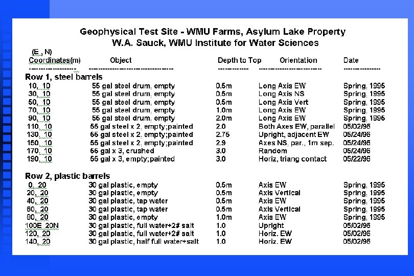
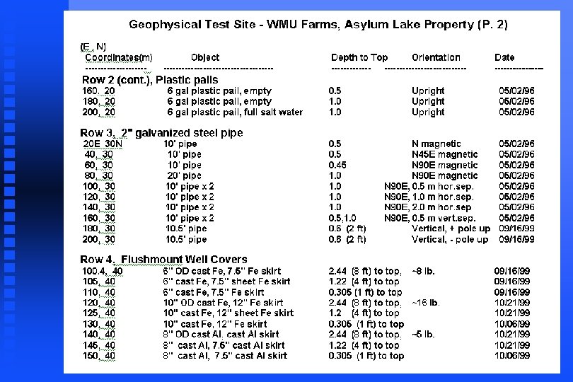
Subsurface Targets n Row 1: 55 gal steel drums (empty). u Singles at 0. 5 m and 1 m depth u Pairs in various orientations u Trios in various orientations n Row 2: 30 gal Plastic drums; 6 gal pails u Empty, n Row 3: 3. 05 m x 5 cm steel pipe (2” x 10’) u Singles n half-filled or filled with tap water, salt water. at various orientations, pairs Row 4: [ half is reserved for archaeology] u Steel and Aluminum flushmount well covers
& Steel drums are buried singly at various orientations and depths, then in pairs and trios along row 10 N. 30 Gal plastic drums with water or partially filled with water are along row 20 N. Steel pipes (10 ft x 2 inches) in various orientations and depths, and pairs are along row 30 N. The archaeology 10 m x 10 m squares, as well as flush-mount well covers at 3 depths, are in row 40 N, and contain numerous small objects.
Excavating for plastic drums; WMU Test Site
One of WMU field trucks with water trailer
Two freshly painted steel drums ready to be covered.
Usage of the site ( WMU ) n n Geophysics Courses: GL 560, 561, 562, 563, 564. Hydrogeology Field Course (geophys. module): GL 525 Master’s Thesis: Justin M. Bailey - “Comparison of Target Detectability and Resolution by 3 Different Horizontal Loop EM Systems at the Asylum L. Geophysical Test Site” (in progress). Funded Research: W. A. Sauck - “Evaluation of Geophysical Techniques for Locating Abandoned Water Supply and Monitor Wells in Michigan”; MDEQ Abandoned Well Management Program, $42, 000.
Geonics EM-61 Asylum Lake
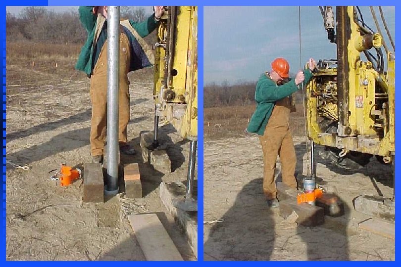
2” x 42’ Black Steel
G-858 Mag.
2” x 21’ Black Steel
Usage of the site ( non-WMU ) n n Schlumberger, Inc. (well logging); logged a deep well with the intent of adapting petroleum well logging tools to the smaller-scale water supply and monitor wells. Sensors & Software(Toronto); Pulse Ekko radar (GPR). Zonge Engineering & Research Organization (Tucson); nano. TEM, a new time-domain EM system for investigations of the shallow subsurface. DUALEM, Inc. (Milton, Ontario); tested DUALEM-4, a new dual-coil electromagnetic system.
Geophysical instruments tested on site. n Magnetometers ; magnetic gradiometers. u n Electromagnetic Induction systems (EM) u n Bison 2390; Syscal R 2 Ground Penetrating Radar (GPR) u n Bison 12 -ch; Geometrics Strataview 24 -channel Electrical Resistivity systems (ER) u n Geonics EM-16, EM-17, EM-31, EM-34, EM-38, EM-61; DUALEM 4 Seismic systems u n Geometrics G-816, G-858, Schonstedt GA-72 CV; Fisher FX-3 GSSI SIR-10 A+, Sensors & Software Pulse Ekko Well-logging systems u Keck SR-3000 natural gamma ray
Geonics EM-31 Asylum Lake
EM-31 m. Siemens/m
West half of test site - shallow conductivity.
Geonics EM-61 HH (Hand Held)
Map of EM-61 HH results, which show shallow objects best.
GSSI Geo. Phex GEM-300 EM System
GEM-300 @ 2610 Hz
Conclusions n n n The conductive surficial till layer makes GPR and EM surveying very challenging. Only two of the plastic drums have been detected by geophysical means. The polarity of the EM-31 response over steel drums reverses when burial depth exceeds about half the coil separation => null point exists? The multi-frequency GEM 300 / GEM-2 have the potential to discriminate between target types based on spectral response. Pipes & drums have strong perm. magnetization.
Conclusions / Future Directions n n This site has attracted international interest by equipment manufacturers and has given WMU faculty and students valuable previews of a number of new geophysical systems. Hundreds of students have learned the responses of objects typical of sites which must be characterized by environmental / engineering companies. Targets of the type found at colonial archaeology sites were emplaced in 2000. This is a low-impact use, conformable with the nature preserve envisioned for the entire property.
Typical View of WMU Geophysical Test Site
Thank You