The Weekend Navigator Basic Level I Copyright 2008

The Weekend Navigator Basic Level I Copyright 2008 Coast Guard Auxiliary Association, Inc.

Chapter 4: The Tools of Navigation

Chapter 4: Lesson Objectives • Charts and their construction • Mercator projection versus a polyconic projection • Pros and cons of Mercator projections • Pros and cons of polyconic projections • Reading a chart

Chapter 4: Lesson Objectives • • Navigational tools Using navigational tools Using other navigational tools Lesson experience using plotting exercises

What are the Tools of the Trade? • • • Charts Aids to navigation Plotting tools Compasses Electronic navigation instruments

What is a Nautical Chart? • Provides information what is on and under the water • Scaled representation of the earth, accurately portraying shapes, distances, and directions • Charts are made to be drawn on!

Who Prepares Nautical Charts? • Information is provided by the National Oceanographic and Atmospheric Administration (NOAA) • Charts are prepared by the National Ocean Service (NOS)

How to Project the Earth on a Flat Chart? • Done by using projections for specific applications • Two types of maps: – Mercator projections – Polyconic projections

Mercator Projection? • Parallels of latitude are horizontal and straight • Meridians of longitude are vertical and straight • Parallels intersect the meridians at right angles

Advantages of a Mercator Projection • You can measure and plot directions and distance directly on the chart and use them for navigation • Maintains directional relationships better over long distances • Projection of choice for coastal and offshore navigation

Disadvantages of a Mercator Projection • Distorts the shapes and relative sizes of landmasses and ocean basins – Land masses will appear larger than they actually are • Distortion becomes exaggerated near the poles

Polyconic Projection • Developed from a series of cones placed over the earth’s surface and then flattened • In local areas, the parallels are perpendicular with the meridian • Courses can be plotted

Polyconic Projection

Polyconic Projection

Advantages of a Polyconic Projection • Used for inland lake nautical charts – Great Lakes and major river systems

Disadvantages of a Polyconic Projection • Not suitable for plotting travel over great distances

What Information is Found on a Chart? • • Depths Scales Updates Coordinates Symbols Chart grid Horizontal datum

Depths • Soundings are plotted depth measurements either in feet or fathoms • Vertical datum or standard is established because of fluctuating water levels in tidal regions – Mean low water (MLW) – Mean lower low water (MLLW)

Depths • Depth contour lines are used to identify points of selected constant depth – Plotted in multiples of fathoms (6 feet) – Contour depths are oriented with the contour and is in contrasting print (italic vs. regular)

Depths • • Shallow water is colored light blue Deep water is colored white Very shallow water is colored green Land is colored tan

Scales • Charts come in variety of scales – 1: 40, 000 -scale means 1 inch on the chart equals 40, 000 inches (1/2 nautical mile) • Local waters: 1: 20, 000 scale • Harbors: 1: 10, 000 scale • Open waters: 1: 80, 000 scale

Scales • The smaller the ratio, the larger the scale and the more detail (i. e. 1: 10, 000) – Good for navigation in narrow and rock-strewn waters • The larger the ratio the smaller the scale and the less detail (i. e. 1: 80, 000) – Good for “big picture” cruise planning

Updates • Updated only at intervals • Updates provided by hydrographic via Notice to Mariners (NTM) • Updates provided by the USCG via Local Notice to Mariners (LNM)

Chart Grid and Horizontal Datum • Utilizes a system of coordinates of latitude and longitude • Horizontal datum is a framework that allows for a common reference • World Geodetic System 1984 (WGS-84) is used today as the horizontal datum

Coordinates • Latitude and longitude provide a nautical position address • Latitude scale is found on the left and right margins of the chart • Longitude scale is found on the top and bottom margins

Coordinates • Meridians are lines of longitude or vertical slices that pass through both poles • Prime Meridian is at 0 o and passes through Greenwich, England • All meridians are great circles

What is a Great Circle? • An imaginary line scribed on the Earth’s surface by a plane passing through the exact center of the Earth

Rhumb Line • Rhumb line is a course on a single bearing

Finding Your Spot on the Earth • Scales on coastal nautical charts are divided into: – Degrees – Minutes – Tenths of minutes • A minute of angle is 1/60 th of a degree

Finding Your Spot on the Earth • A minute of latitude is always exactly equal to one nautical mile • The latitude scale can be used for measuring distance on the a chart • A minute of longitude is equal to one nautical mile only at the equator, but can not be used for measuring distance on a chart

Chart Symbology • Rocks • Wrecks • Other obstacles

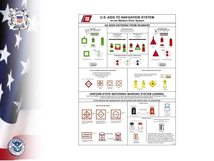
Navigation Aids • Lateral aids or marks indicate the sides and center of the channel – “Red right returning” rule of lateral marking – Safe water or mid channel marks – Day beacons – Lighted beacons

Navigation Aids • Informational aids mark dangers or note local rules – No-wake zones – Barge moorings – Anchorage areas – Wing dams on rivers – Rocky areas – Swimming beaches

Day Beacons • Day beacons are unlighted fixed navigation aids – Indicated on a chart by a green square or red triangle – May be on land or in shallow waters on poles


Lighted Beacons • Lighted fixed navigation aid indicated on a chart by a symbol that resembles an exclamation mark – Solid black dot indicates actual position – Magenta teardrop flare indicates it is lighted

Characteristics of Lighted Beacons • Characteristics are printed next to the symbol – Pattern of “ 4 s” mean 4 second intervals – Colors of “R” (red), “G” (green), “Y” (yellow), and “W” (white) – Height of the aid – Visible range of the aid
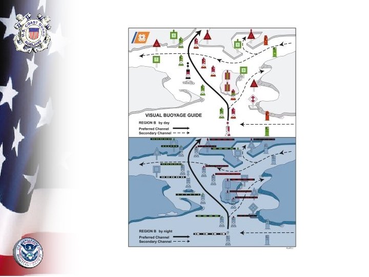

Light Patterns • Certain navigational aids have prescribed light patterns • Lighted center channel buoy flashes a Morse code “A” (short-long) pattern with white light • Junction buoy will flash a two short plus one short (2+1) pattern either red or green

Buoys • Buoys have a small, open, black circle with a diamond flare • Color of the buoy is given in the label – “R” = red, “G” = green, “RW” = red/white
 is conical is shape and red in color •")
Buoys • Nun buoy (“N”) is conical is shape and red in color • Can buoy (“C”) is cylindrical and green in color • Mid channel buoy has red/white vertical stripes and a white light

Other Buoys • Sound-making buoys – Bell buoys – Gong buoys – Siren buoys • Light colors may be red, green, or white

Plotting Tools • Dividers • Parallel rules • Protractor • Tool kit

Dividers • Used to measure distances • Used to measure latitude and longitude coordinates • Drawing compass is similar to dividers

Determining Latitude Coordinate • One point is placed on spot of interest and other point is on a line of latitude • Divider is transferred to latitude scale – Read as degrees, minutes, and 1/10 ths of minutes north (N)

Measuring Distance Using Dividers • One point is placed on each end of the distance • Divider is transferred to distance scale to determine the distance measurement

Measuring Distance Using Dividers • Remember: Most charts have distance scales in nautical miles, statute miles, and kilometers. On the water, use nautical miles because of the natural relationship with latitude

Measuring Distance Using Dividers • Distance longer than dividers? – “walk” your dividers along the distance line

Parallel Rules • Consists of a pair rules joined by two or more swinging hinges • Serve as a straight edge for plotting • Helps transfer a plotted bearing line across the chart to compass rose

Rolling Parallel Rules • One straight edge • Moves across the chart on a long roller

Protractor Plotting Tool • Easier to use than parallel rules particularly in cramped spaces

Navigation Tool Kit • • • Drawing compass Calculator Notebook Pencils/erasers Waterproof sleeves for charts

Other Navigation Tools • Ship’s compass • Hand bearing compass • Global Positioning System (GPS) • Other electronics

The Ship’s Compass • Every boat should have a compass. • Quality and size are important • Deviation must be adjusted for and done by a professional

Hand Bearing Compass • A handheld magnetic compass with a built in sight • Used to take visual bearings • Always use the compass from a single spot near the helm
 • Most popular electronic navigation system • Must have a")
Global Positioning System (GPS) • Most popular electronic navigation system • Must have a clear view of the sky above the boat and be able to receive simultaneous satellite signals • Remember: A GPS position is just an abstraction until it is plotted on a chart!

Other Electronic Devices • Radar – Powerful and versatile tool for fixing positions using bearings and ranges – Only electronic device for tracking other vessels • Depth sounder – Tells the depth of water directly under your boat – Useful to compare depth readings with chart soundings

Other Electronic Devices • Fluxgate compass – Helps eliminate potential errors caused by friction of compass card – Self-compensate for local magnetic variation • Autopilot – Mechanical device that controls the boat’s rudder – Must be connected to a fluxgate compass or GPS device

Other Electronic Devices • VHF radio – Valuable tool especially in emergencies – New radios include a digital selective calling (DSC) function – DSC transmits your position when a call is made – Assists the USCG in determining your position

Summary • Nautical charts – Depths – Scales – Updates – Chart grid – Horizontal datum – Coordinates – Symbology

Summary • Navaids – Beacons – Buoys • Plotting tools – – Dividers Parallel rules Protractor Tool kit • Compasses – Ship’s compass – Hand bearing compass • Other navigation tools – – – GPS Radar Depth sounder Fluxgate compass Auto pilot VHF radio
- Slides: 62