
The use of the Consolidated Prediction Format at





- Slides: 24
The use of the Consolidated Prediction Format at Zimmerwald Werner Gurtner Astronomical Institute University of Bern ILRS Workshop 3 -7 October 2005 Eastbourne
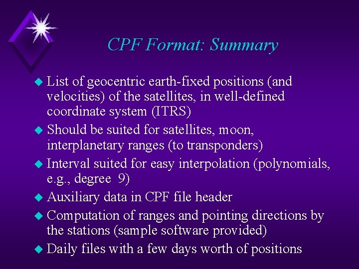
CPF Format: Summary u List of geocentric earth-fixed positions (and velocities) of the satellites, in well-defined coordinate system (ITRS) u Should be suited for satellites, moon, interplanetary ranges (to transponders) u Interval suited for easy interpolation (polynomials, e. g. , degree 9) u Auxiliary data in CPF file header u Computation of ranges and pointing directions by the stations (sample software provided) u Daily files with a few days worth of positions
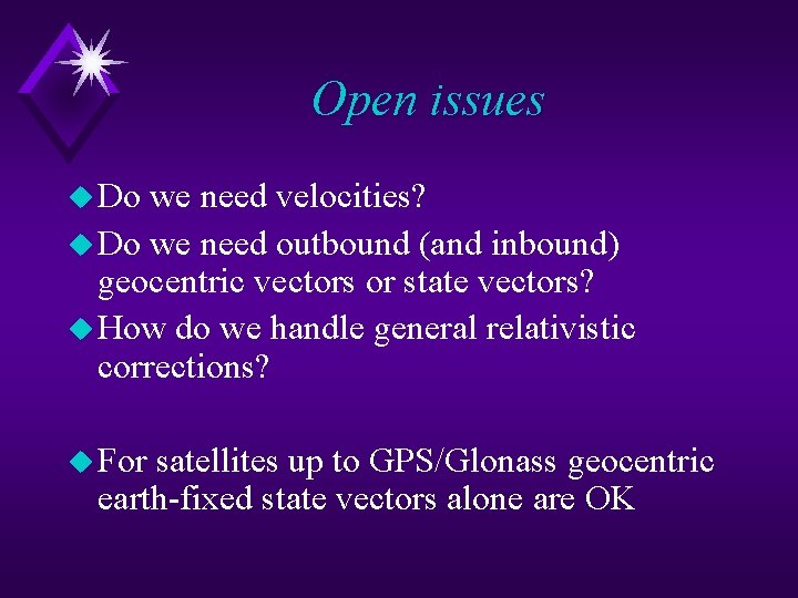
Open issues u Do we need velocities? u Do we need outbound (and inbound) geocentric vectors or state vectors? u How do we handle general relativistic corrections? u For satellites up to GPS/Glonass geocentric earth-fixed state vectors alone are OK
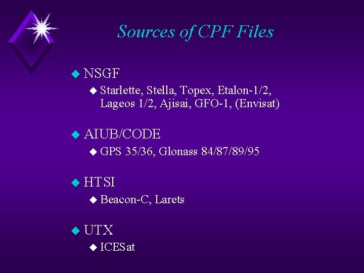
Sources of CPF Files u NSGF u Starlette, Stella, Topex, Etalon-1/2, Lageos 1/2, Ajisai, GFO-1, (Envisat) u AIUB/CODE u GPS 35/36, Glonass 84/87/89/95 u HTSI u Beacon-C, u UTX u ICESat Larets
Handling of CPF Files (separately for each satellite) u CPF files are daily received by mail (a few days worth of data) u Add new records to / replace old records in merged file (Take only records in and around predicted pass intervals to keep merged file smaller, delete records older than 10 days) u Generate u u u weekly pass list Compute velocity for late epoch (Lagrange interpolation: Sr HERMITE) Compute osculating elements for late epoch Determine actual pass times (geometry, visibility, illumination)
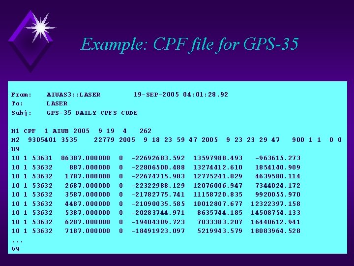
Example: CPF file for GPS-35 From: To: Subj: AIUAS 3: : LASER 19 -SEP-2005 04: 01: 28. 92 LASER GPS-35 DAILY CPFS CODE H 1 CPF 1 AIUB 2005 9 19 H 2 9305401 3535 22779 H 9 10 1 53631 86387. 000000 10 1 53632 887. 000000 10 1 53632 1787. 000000 10 1 53632 2687. 000000 10 1 53632 3587. 000000 10 1 53632 4487. 000000 10 1 53632 5387. 000000 10 1 53632 6287. 000000 10 1 53632 7187. 000000. . . 99 4 262 2005 9 18 23 59 47 2005 0 0 0 0 0 -22692683. 592 -22806500. 488 -22674715. 983 -22322988. 129 -21782775. 741 -21090035. 585 -20283744. 971 -19404309. 723 -18491923. 097 9 23 23 29 47 13597988. 493 13274412. 610 12775241. 829 12076006. 947 11158720. 835 10012807. 677 8635744. 185 7033383. 207 5219943. 579 900 1 1 -963615. 273 1854140. 909 4639580. 114 7344024. 172 9920055. 970 12322397. 158 14508754. 133 16440612. 941 18083964. 528 0 0
Prediction Generation u Interpolate satellite positions for reflection times in appropriate intervals during satellite pass u Interpolation: Sr HERMITE u Iteration u Compute u Ranges / flight times (subtract corner cube z positions for GPS, Glonass) u Pointing elements (azimuth, elevation) u Point-behind angle u Allow for u Tropospheric u Time biases corrections
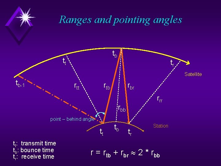
Ranges and pointing angles tb tt tr Satellite tb-1 rtt rtb rbr rrr rbb point – behind angle tt tt: transmit time tb: bounce time tr: receive time tb tr Station r = rtb + rbr 2 * rbb
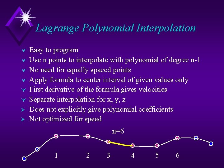
Lagrange Polynomial Interpolation Ú Ú Ú Ø Ø Easy to program Use n points to interpolate with polynomial of degree n-1 No need for equally spaced points Apply formula to center interval of given values only First derivative of the formula gives velocities Separate interpolation for x, y, z Does not explicitly give polynomial coefficients Not optimized for speed n=6 1 2 3 4 5 6
Lagrange Polynomial Interpolation Ú Ú Ú Ø Ø Easy to program Use n points to interpolate with polynomial of degree n-1 No need for equally spaced points Apply formula to center interval of given values only First derivative of the formula gives velocities Separate interpolation for x, y, z Does not explicitly give polynomial coefficients Not optimized for speed n=6 1 2 3 4 5 6
Software: Interpolation Subroutine SUBROUTINE HERMITE(ITYP, X, Y, Z, NMAX, NVAL, XP, YP, ZP, IRCODE) ----------------------------Interpolation by a polynomial using NVAL out of NMAX given data points Input : ITYP NVAL NMAX X(I) Y(I) Z(I) XP : 1: use Lagrange polynomial of degree NVAL-1 2: use Hermite formula: Polynomial of degree 2*NVAL-1 : : : number of points to use for interpolation number of given points in list arguments of given values (I=1, . . . , NMAX) functional values Y=f(X) derivatives Z=f’(X) interpolation argument Output: YP : interpolated value at XP ZP : first derivative of YP (ITYP=1 only) IRCODE: return code (0=ok, 2=error) The function selects the NVAL values to be used for interpolation such that the interpolated data point is located in the center interval. (Works best for NVAL = even number, of course).
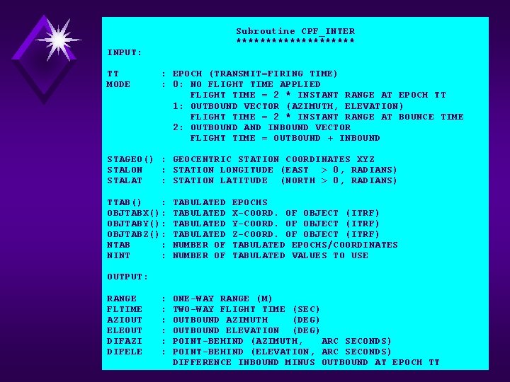
INPUT: TT MODE Subroutine CPF_INTER ********** Subroutine CPF_INTER : EPOCH (TRANSMIT=FIRING TIME) : 0: NO FLIGHT TIME APPLIED FLIGHT TIME = 2 * INSTANT RANGE AT EPOCH TT 1: OUTBOUND VECTOR (AZIMUTH, ELEVATION) FLIGHT TIME = 2 * INSTANT RANGE AT BOUNCE TIME 2: OUTBOUND AND INBOUND VECTOR FLIGHT TIME = OUTBOUND + INBOUND STAGEO() : GEOCENTRIC STATION COORDINATES XYZ STALON : STATION LONGITUDE (EAST > 0, RADIANS) STALAT : STATION LATITUDE (NORTH > 0, RADIANS) TTAB() : OBJTABX(): OBJTABY(): OBJTABZ(): NTAB : NINT : TABULATED NUMBER OF EPOCHS X-COORD. OF OBJECT (ITRF) Y-COORD. OF OBJECT (ITRF) Z-COORD. OF OBJECT (ITRF) TABULATED EPOCHS/COORDINATES TABULATED VALUES TO USE OUTPUT: RANGE FLTIME AZIOUT ELEOUT DIFAZI DIFELE : : : ONE-WAY RANGE (M) TWO-WAY FLIGHT TIME (SEC) OUTBOUND AZIMUTH (DEG) OUTBOUND ELEVATION (DEG) POINT-BEHIND (AZIMUTH, ARC SECONDS) POINT-BEHIND (ELEVATION, ARC SECONDS) DIFFERENCE INBOUND MINUS OUTBOUND AT EPOCH TT
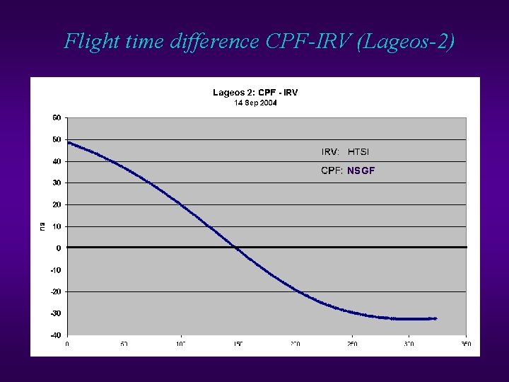
Flight time difference CPF-IRV (Lageos-2) NSGF
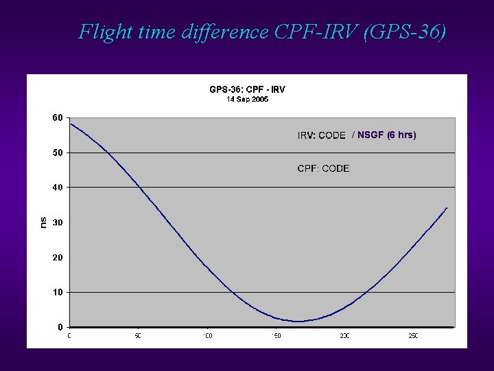
Flight time difference CPF-IRV (GPS-36) / NSGF (6 hrs)
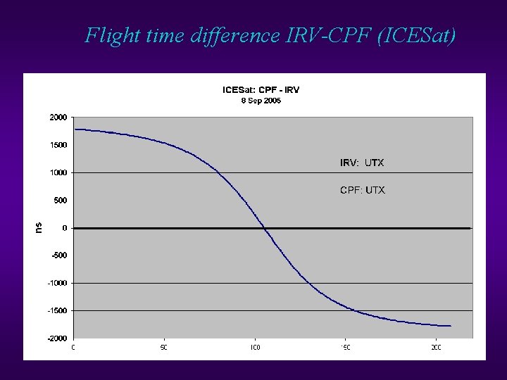
Flight time difference IRV-CPF (ICESat)
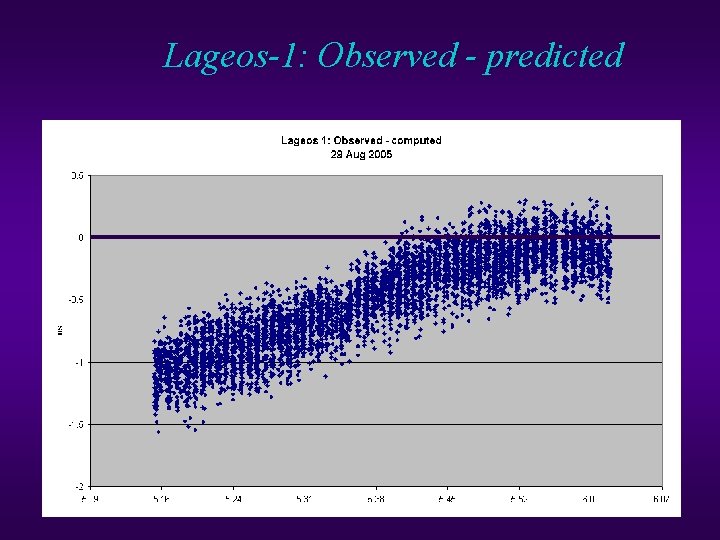
Lageos-1: Observed - predicted
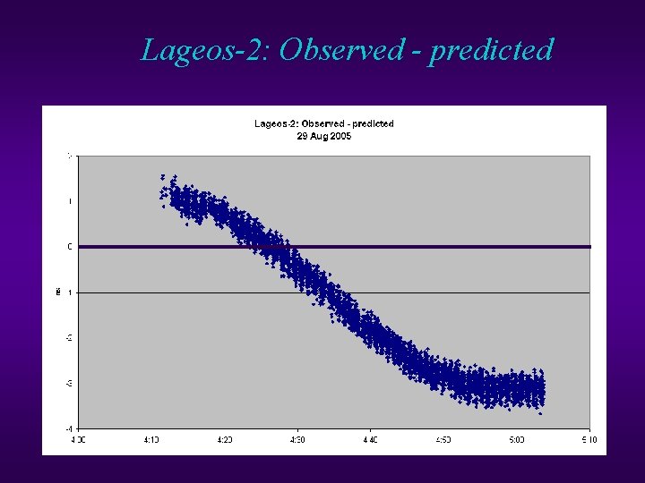
Lageos-2: Observed - predicted
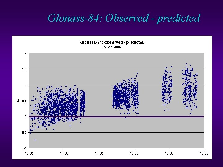
Glonass-84: Observed - predicted
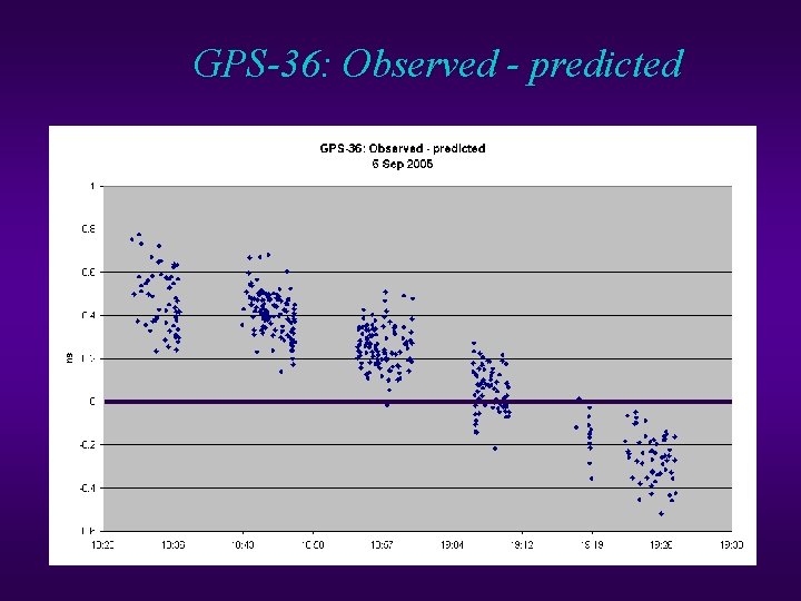
GPS-36: Observed - predicted
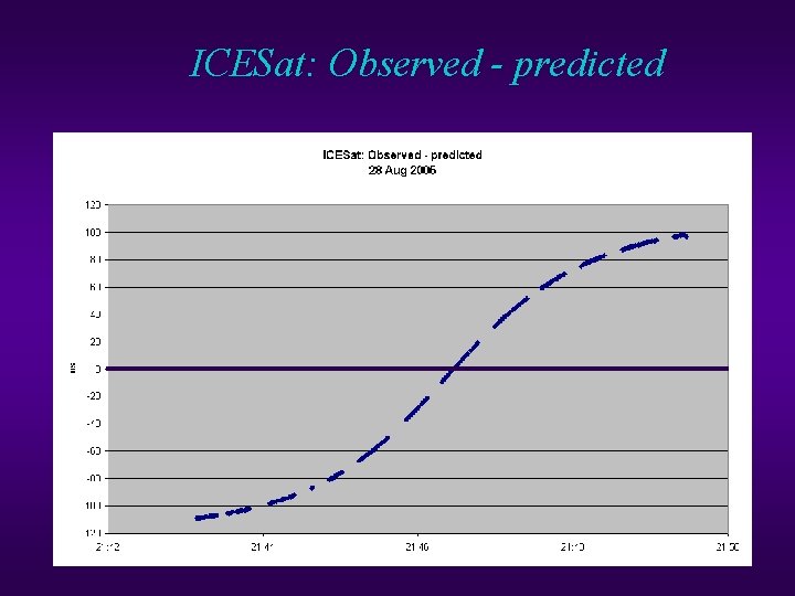
ICESat: Observed - predicted
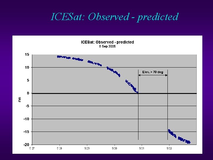
ICESat: Observed - predicted
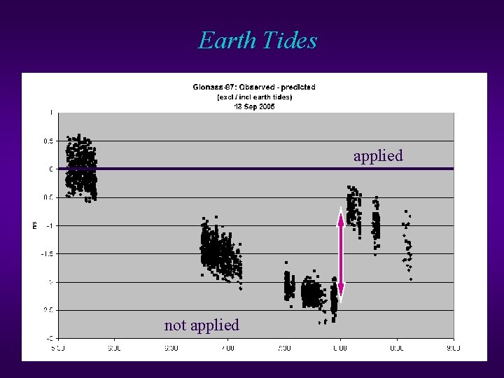
Earth Tides applied not applied
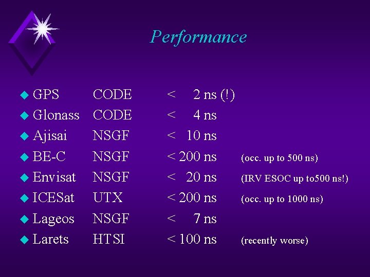
Performance u GPS CODE u Glonass CODE u Ajisai NSGF u BE-C NSGF u Envisat NSGF u ICESat UTX u Lageos NSGF u Larets HTSI < 2 ns (!) < 4 ns < 10 ns < 200 ns < 7 ns < 100 ns (occ. up to 500 ns) (IRV ESOC up to 500 ns!) (occ. up to 1000 ns) (recently worse)
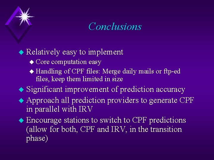
Conclusions u Relatively easy to implement u Core computation easy u Handling of CPF files: Merge daily mails or ftp-ed files, keep them limited in size u Significant improvement of prediction accuracy u Approach all prediction providers to generate CPF in parallel with IRV u Encourage stations to switch to CPF predictions (allow for both, CPF and IRV, in the transition phase)