The Urbanization Activity Urban Sprawl and Its Effects

The Urbanization Activity Urban Sprawl and Its Effects

For this game you will need…. • • • Large sheet of blank paper Lined paper Pencil/Eraser Ruler Coloring pencils (optional)

Early Settlements Early settlements were often agricultural settlements, these were areas of low population density and often dispersed to allow space for farmers to farm their crops.

Round 1 • Draw: – – 1 River 2 -3 cm wide and runs from edge to edge 2 bridges 4 main roads (single line) 8 houses (approx 1 -2 cm, foundation of a house must touch a road, number each house)

Round 2 • • Select 1 house which will be yours and shade it in Draw: – – 1 church 1 cemetery 2 stores 1 pub/restauraunt

Resource Based Settlements Sometimes isolated rural settlements would occur which formed out of resource-based settlements, these are often referred as mining, fishing, and forestry towns.

Round 3 • • Draw a mine on an isolated part of your map Place 4 houses in close proximity to the mine

Service Based Settlement Some people settled in isolated areas because they can earn a living by providing services to residents and to travelers passing through. Often these settlements would be scattered along major roads.

Service Based Settlement Some people settled in isolated areas because they can earn a living by providing services to residents and to travelers passing through. Often these settlements would be scattered along major roads.

Round 4 • Draw 2 pairs of house/store on your map, it must be connected to a road

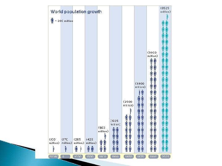
Population Growth • • • Around 1750 and onward, population began to grow at an ever-increasing rate. What were some of the reasons? Food production/distribution Improvements in public health (soap, sewage lines, etc. ) Conquest of disease (medicine, vaccines, etc. )

Population Growth • • • Around 1750 and onward, population began to grow at an ever-increasing rate. What were some of the reasons? Food production/distribution Improvements in public health (soap, sewage lines, etc. ) Conquest of disease (medicine, vaccines, etc. )

Round 5 • • • Draw 6 more houses 1 more church 1 more road 1 more pub/restaurant 1 more river bridge 1 more store

Villages As agricultural productivity improved over time and food surpluses became larger, people no longer needed to produce their own food. People started to become specialist in their field, such as weaving, making metal objects, milling, baking. Since these specialists were offering goods and services to others, it made sense for them to live close together.

Round 6 • Draw 2 services and 4 houses on one location of your map and 1 service and 2 houses on another location

Towns As villages began to grow, they started to form towns and cities. The goods and services produced in these towns and cities were exchanged for food products in the countryside.

Round 7 • • Create a space on your map that will represent the amount of agricultural land needed to support your population. Label this land “Agricultural Use Only”. Erase and re-locate any houses/businesses in that area. Add 10 more houses to your map

Industries In order for these cities to grow even larger and increase their economic base, they needed basic industries. A greater population base and improvements in transportation allowed cities to build factories and manufacturing plants to produce goods, some of which were sold locally while others were shipped and sold to other communities.

Round 8 • • • Add a railroad from one edge of the map to another Add 3 factories or manufacturing plants on your map Add 5 houses Add 3 apartments Add 2 estates (mansions) Add 1 office building

Feed The Need As cities continue to expand, there becomes a growing need for services and entertainment. Some cities even become tourist hotspots so that they can bring in more outside money. Both physical and human features can draw in tourists (ie. Niagara Falls, Wonderland, CN Tower)

Round 9 • Draw: – – – 2 tourist attractions Another road 8 more houses 2 theatres 2 apartments 1 government building

Impacts of Urbanization • 21 st century city faces many challenges – – Social and economic stratification Wasteful consumption of resources Transportation congestion Environmental degradation

Impacts of Urbanization • More then 50% of the world’s population lives in cities – • Enormous pressure on: – – – • By 2030, estimated 5 billion Transportation systems Housing stock Infrastructure Increased greenhouse gas production

Questions To be done individually. 1. 2. 3. 4. 5. List and describe 2 reasons that towns and cities grow. What were some of the difficulties you faced in placing your buildings on your map. How might this relate to the real world? Define “urban sprawl” and explain how it relates to your map. What pushed people into your city, what pulled people into your city? If you could control the development of a future town or city, what laws would you put into place to make it a better place to live?

New Urbanism • Promotes the creation and restoration of: – – – Diverse Walkable Compact Vibrant Mixed-use communities

New Urbanism • • These are composed of the same components as conventional development, but assembled in a more integrated fashion, in the form of complete communities. Housing, work places, shops, entertainment schools, parks, and civic facilities essential to the daily lives of the residents, all within easy walking distance to each other

Principals of New Urbanism • • • Walkability Connectivity Mixed use and diversity Mixed housing Quality Architecture and Urban Design Traditional neighbourhood design Increased density Sustainability Smart transportation Quality of life

Walkability • • • Most things within a 10 -min walk of home and work Pedestrian friendly street design (buildings close to street; porches, windows & doors; tree-lined streets; on street parking; hidden parking lots; garages in rear lane; narrow, slow speed streets). http: //vimeo. com/41261102

Connectivity • • • Interconnected street grid network disperses traffic & eases walking A hierarchy of narrow streets, boulevards, and alleys High quality pedestrian network and public realm makes walking pleasurable

Mixed Use & Diversity • • A mix of shops, offices, apartments, and homes on site. Mixed-use within neighbourhoods, within blocks, and within buildings Diversity of people – of ages, income levels, cultures, and races

Mixed Housing • A range of types, sizes, and prices in closer proximity

Quality Architecture & Urban Design • • • Emphasis on beauty, aesthetics, human comfort, and creating a sense of place Special placement of civic uses and sites within community Human scale architecture & beautiful surroundings nourish the human spirit

Traditional Neighbourhood Structure • • • Discernable center and edge Public space at center Importance of quality public realm; public open space designed as civic art Contains a range of uses and densities within 10 -minute walk Transect planning: Highest densities at town center; progressively less dense towards the edge.

Increased Density • • More buildings, residences, shops, and services closer together for ease of walking, to enable a more efficient use of services and resources, and to create a more convenient, enjoyable place to live New Urbanism design principles are applied at the full range of densities from small town, to large cities

Smart Transportation • • A network of high-quality trains connecting cities, towns, and neighbourhoods together. Pedestrian-friendly design that encourages a greater use of bicycles, rollerblades, scooters, and walking as daily transportation

Sustainability • • • Minimal environmental impact of development and its operations Eco-friendly technologies, respect for ecology and value of natural systems Energy efficiency Less use of finite fuels More local production More walking, less driving

Quality of life • Taken together these add up to a high quality of life well worth living, and create places that enrich, uplift, and inspire the human spirit

Smart Growth • An urban planning and transportation theory that concentrates growth in compact walkable urban centers to avoid sprawl. – Advocates compact, transit-oriented, walkable bicycle-friendly land use, including neighbourhood schools, complete streets, and mixed-use development with a range of housing choices.

Smart Growth • There are 10 accepted principles that define Smart Growth – Mix land use – Take advantage of compact building design – Create a range of housing opportunities and choices – Create a walkable neighbourhood – Foster distinctive, attractive communities with a strong sense of place – Preserve open space, farmland, natural beauty, and critical environmental areas – Strengthen and direct development towards existing communities – Provide a variety of transportation choices – Make development decisions predictable, fair, and cost effective – Encourage community and stakeholder collaboration in development decisions.
- Slides: 40