THE STRUCTURE OF THE EARTH THE INTERNAL STRUCTURE


- Slides: 105
THE STRUCTURE OF THE EARTH
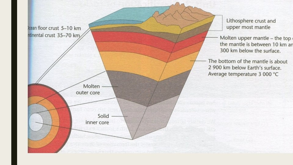
THE INTERNAL STRUCTURE OF THE EARTH ■ Geomorphology is the study of the earth’s physical feature and the processes that forms it. ■ Crust – outer shell forms the land as well as the rocks under the ocean. ■ Mantle – very hot rock under the crust. Makes up 80% of the earths volume. ■ Molten – hot sticky liquid. ■ Core – divided into inner and outer core. Outer core very hot molten material and inner solid.
CLASSIFICATION OF ROCKS. ■ More than 70% of the earths crust is covered by water. ■ We see rocks above the ground as hills and mountains. ■ Most of the rocks are covered by sand etc. ■ Rocks are divided into three main categories. ■ 1 – Igneous ■ 2 – Sedimentary ■ 3 - Metamorphic
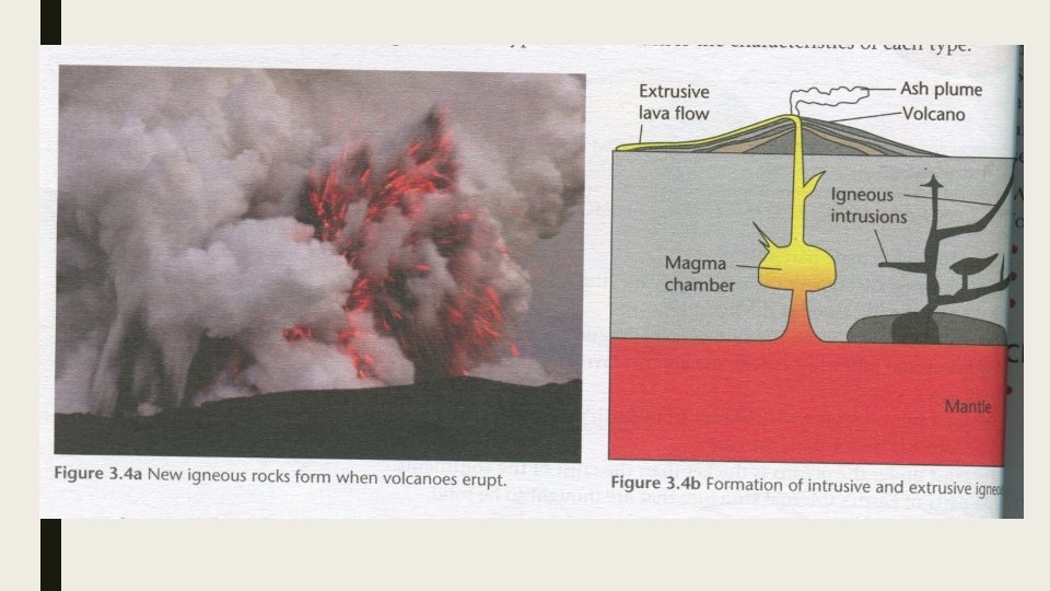
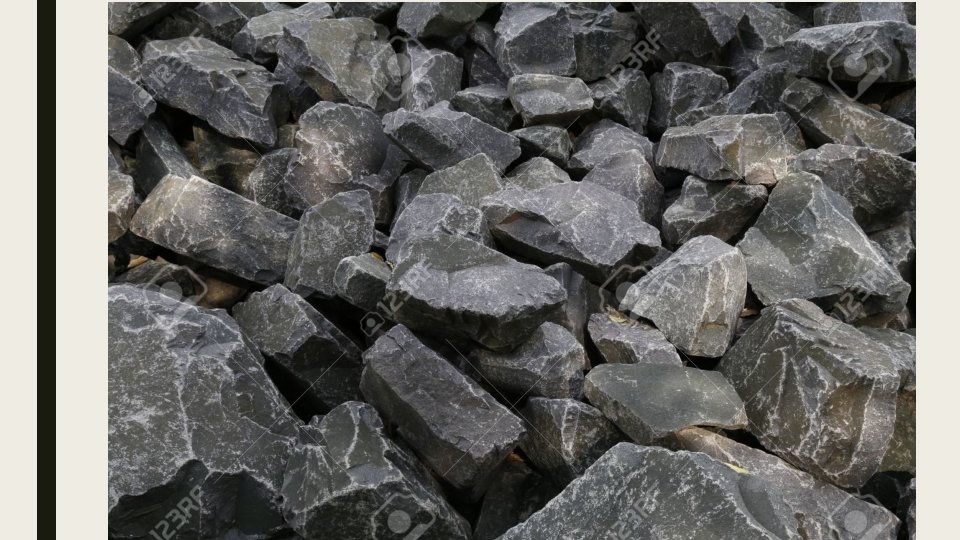
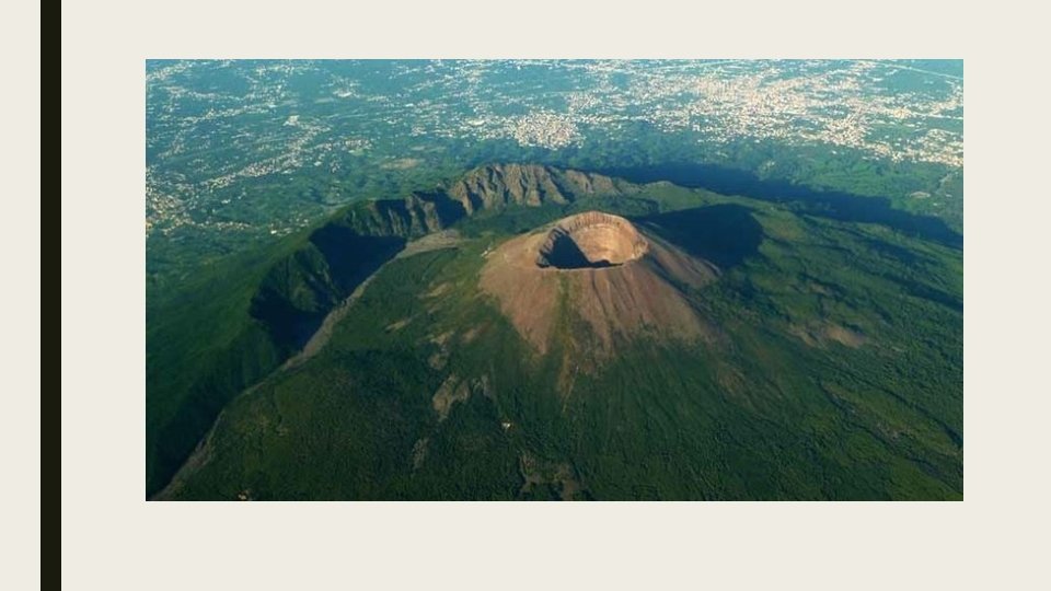
IGNEOUS ROCKS ■ Forms when hot liquid called magma cools down and become solid. ■ Igneous rock form when volcanoes erupt and pour lava and ash onto the surface. ■ Classify it according to where and when it forms. ■ Surface area – extrusive igneous rock ■ Under the surface of the earth – intrusive igneous rocks.
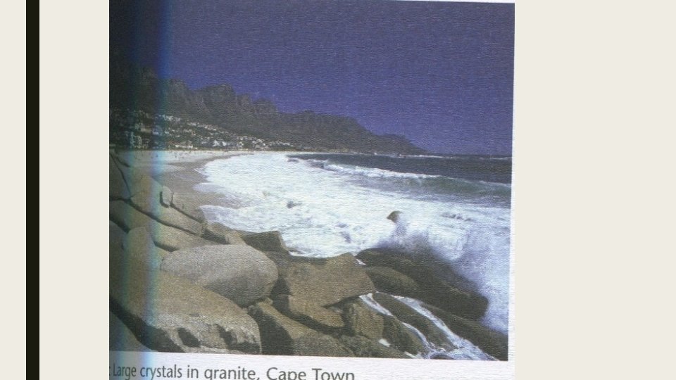
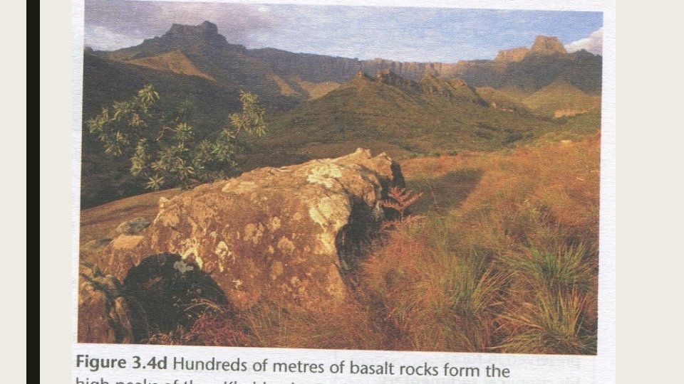
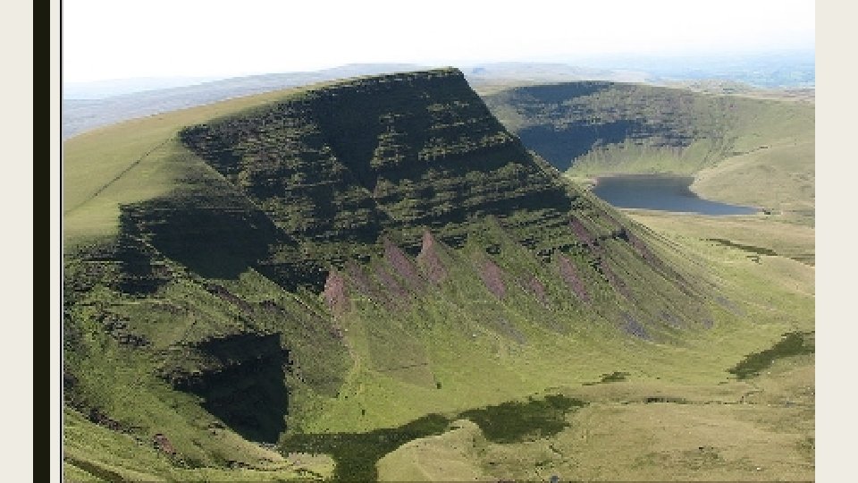
Kinds of igneous rocks Extrusive igneous rocks E. g. Basalt Where formed Composition On the earth’s Small, fine surface from crystals, volcanic and usually dark fissure eruptions Intrusive Inside Earth’s igneous rocks crust: some E. g. Granite igneous intrusions occur deep in the crust Large crystals that can be seen often lighter in colour. Grey Occurrence in SA High peaks of Drakensberg Exposed by erosion or diggings. Cape Mountains.
Exam question structure of the earth
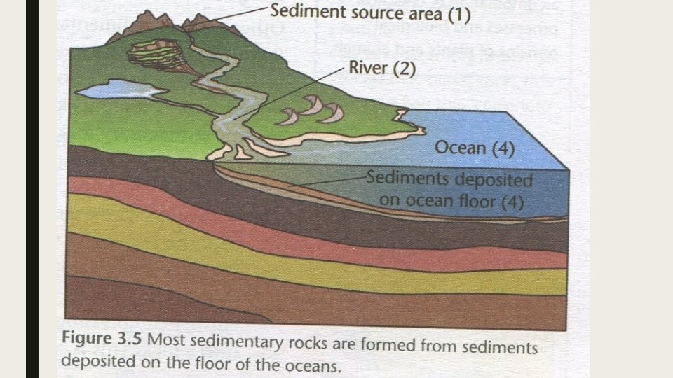
SEDIMENTARY ROCKS ■ Most surface rocks are sedimentary rocks. ■ Formed from sediments which form from sediments that are deposited in water. ■ Pieces of rocks, stones remains of plants and animals ■ Sand mud that’s worn off the land carried in the rivers to the ocean. ■ Examples: sandstones, limestone and coal.
CLASSIFICATION OF SEDIMENTARY ROCKS ■ 1. Clastic sedimentary rocks. ■ 2. Organic sedimentary rocks ■ 3. Chemical and biochemical sedimentary rocks.
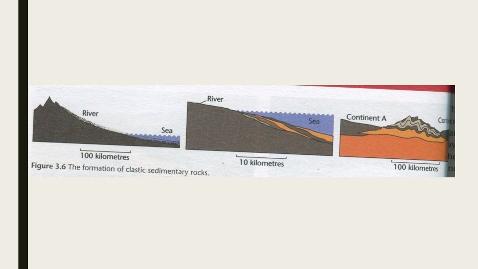
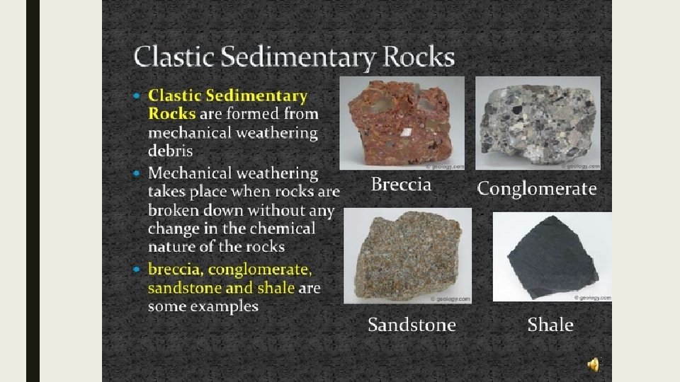
1. CLASTIC SEDIMENTARY ROCKS. ■ Sedimentary rocks formed from small pieces of rock, grains of sand or mud ■ Clasts are the little pieces of broken up rock. Can be as small of as sand grains or as large as pebbles. ■ Sandstone and conglomerate are examples.
PROCESS OF CLASTIC ■ 1 ■ Pieces of rock are loosened by weathering and erosion. ■ Washed or slide downhill into a river. ■ Washed along the river getting smaller as they bounce into other rocks ■ Eventually becomes grains and fine mud
■ 2 ■ Over time sand mud build up on the ocean floor near the mouths of rivers. ■ Weight of the sediment on the bottom layer slowly compresses. ■ Chemicals from the water cement the particles together turning it into sedimentary rock like sandstone.
■ 3 ■ Sediment may be forced above the sea by moving continents
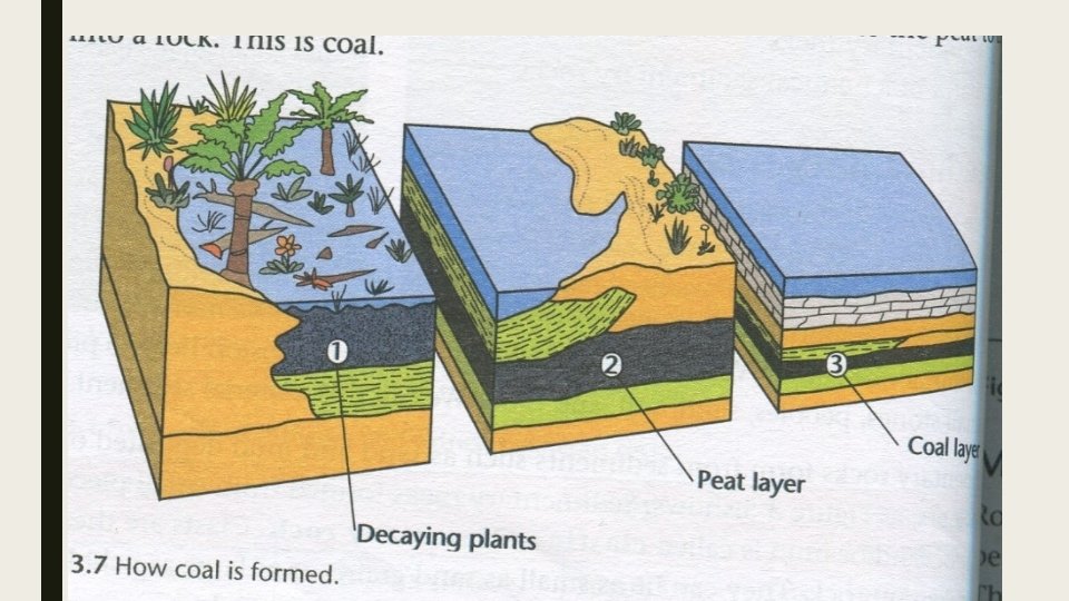
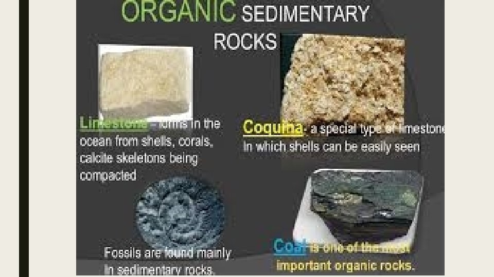
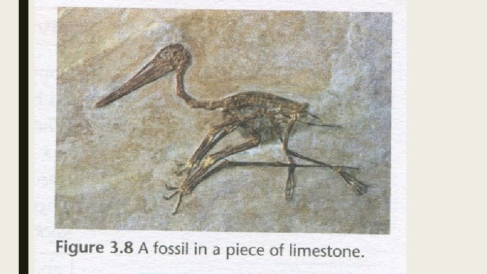
2. ORGANIC SEDIMENTARY ROCKS ■ Remains from plants and animals. ■ Fossils may occur in this sediment. ■ Coal is the example of this
How coal is form ■ coal forms in swampy areas as a result of decay plants in the absence of oxygen. ■ Other sediments such as sand, clay and silt deposit on top of decaying plant. ■ Weight of the sediment compressed underlying decayed organic matter. turning it into a rich dark substance called peat. ■ Squeezed all water peat turns into coal.
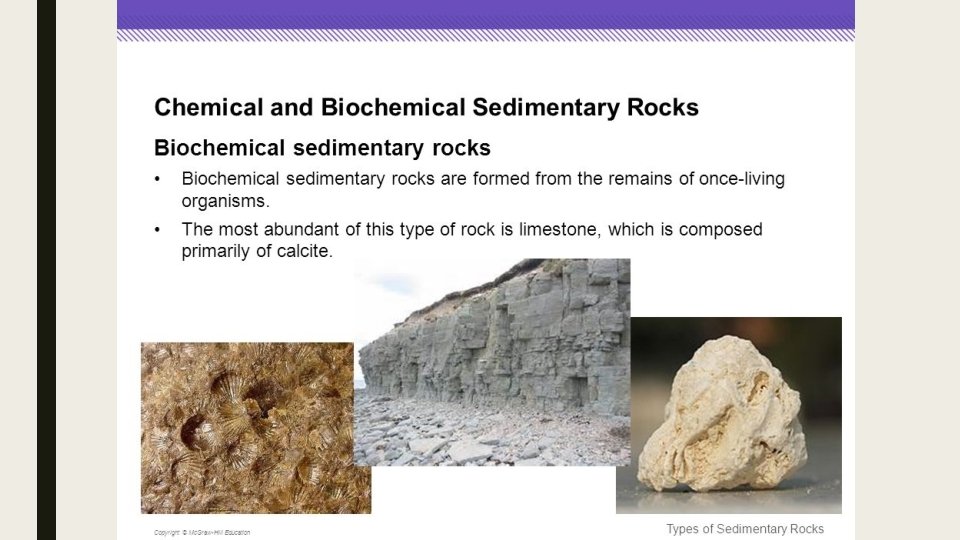
3. CHEMICAL AND BIOCHEMICAL SEDIMENTARY ROCKS ■ Formed by chemical action ■ As water evaporate the chemicals are deposited and eventually form rocks. ■ E. g rock salts. ■ Form by the remains of shells and sea creautres. ■ More accurate to call is biochemical sedimentary rocks.
■ Shells of ancient sea creatures provide material that forms rocks. ■ These shell are microscopically small. ■ Shells are rich in calcium carbonate ■ Some of it dissolves in water. ■ As the layers thicken the weight squashes out water. ■ Calcium carbonate is left as a glue = glues shells together. ■ E. g. limestone.
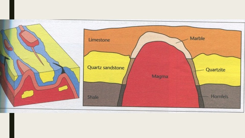
METAMORPHIC ROCK ■ Once igneous or sedimentary rock that has been changed either by pressure or heat.
METAMORPHIC ROCK FORMED BY HEAT. ■ Rocks are baked which are close to the molten rock. ■ Metamorphed by heat = contact metamorphism. ■ They recombine to totally different material. ■ Deep underground or sometimes on the surface when lava comes into contact with other rock
METAMORPHIC ROCK BY PRESSURE ■ Rocks that get squashed between moving land masses. And changes. ■ Change under the pressure of overlaying rocks. ■ E. g. quartzite, marble and slate. ■ Metamorphic rock formed by a combination of heat and pressure.
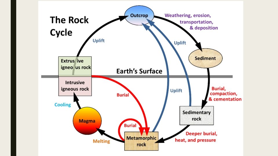
ROCK CYCLE ■ 1. Magma rises into the earths crust. ■ 2. Metamorphic rock changes into magma. ■ 3. Sedimentary rock changes into metamorphic rock due to heat and pressure. ■ 4. Igneous rocks form on the earths surface. ■ 5. Intrusive igneous rocks form within the crust ■ 6. Sedimentary rock formed by compressing of sediments.
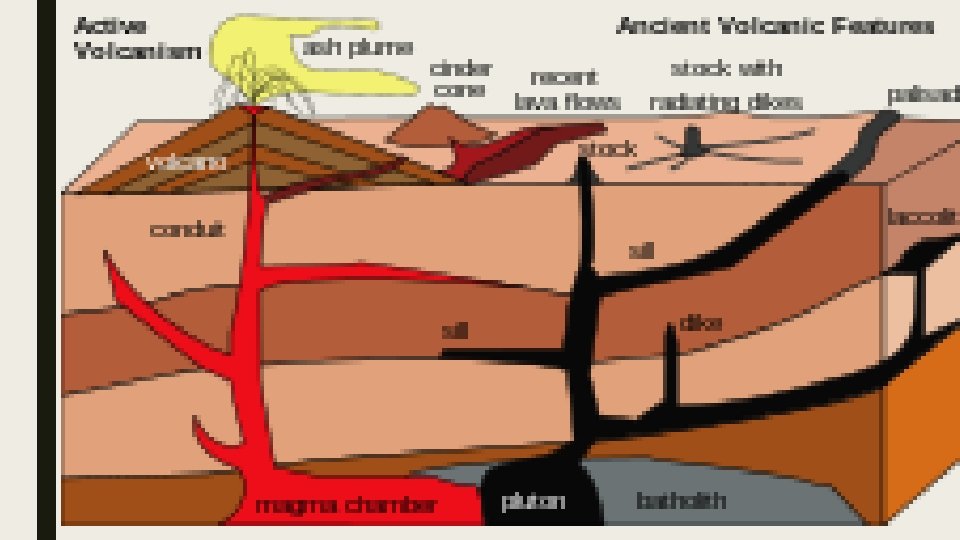
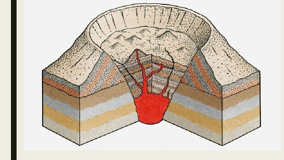
INTRUSIVE IGNEOUS ACTIVITY AND ASSOCIATED FEATURES. ■ Igneous intrusions are classified according to their shape. , depth, size, and how they formed in relation to surrounding rock. ■ Most igneous rock is only seen after erosion of the earths top layer.
BATHOLITH ■ Largest of the igneous intrusions. ■ Cover thousands of km ■ Associated with continental movement. ■ Form deep in the earths crust. ■ Granite is the most common.
LACCOLITHS ■ Much smaller than batholiths ■ Is a dome shaped intrusion. ■ Magma force between layers of the sedimentary rock. ■ Some cause mountains to push up.
MONOLITH ■ Large intrusion that often stands above the surrounding land
DYKES AND SILLS ■ When magma forces its way vertically through layer of rock forms a dyke. ■ Usually only a few meters across. ■ Dolerite is common. ■ Magma forces between rock strata and cools forms a sill. ■ Sills form parallel to the layers of strata.
PIPES ■ Central vents of old volcanoes. ■ Solidified to form carrot-shaped intrusions into the surrounding rock. ■ Often called volcanic pipes.
OVERVIEW OF LANDFORMS ASSOCIATED WITH DIFFERENT ROCKS ■ Tors ■ Lava flows ■ Caldera ■ Domes and monoliths ■ Volcanic neck
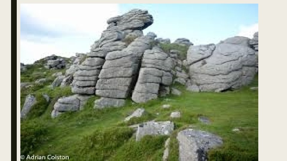
TORS ■ Are the weathered tops of igneous intrusions. ■ Appear rounded as a column of rocks about 20 m
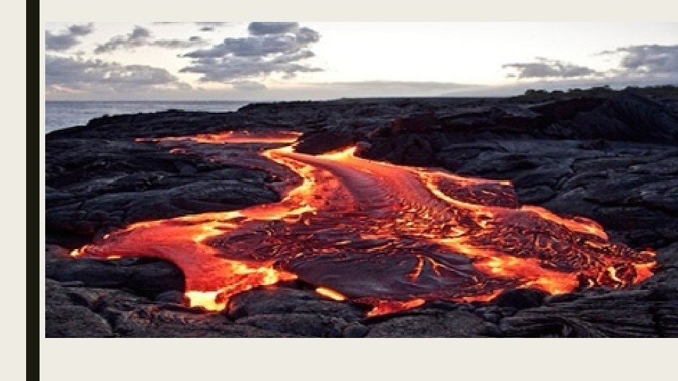
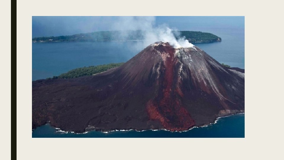
LAVA FLOWS ■ Thin lava flows from vents in the earth’s surface ■ Covers large amount of the earths surface. ■ Example would be basalt
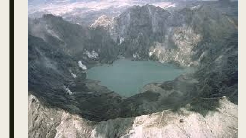
CALDERA ■ Collapse in volcano ■ Normally a lake in the center
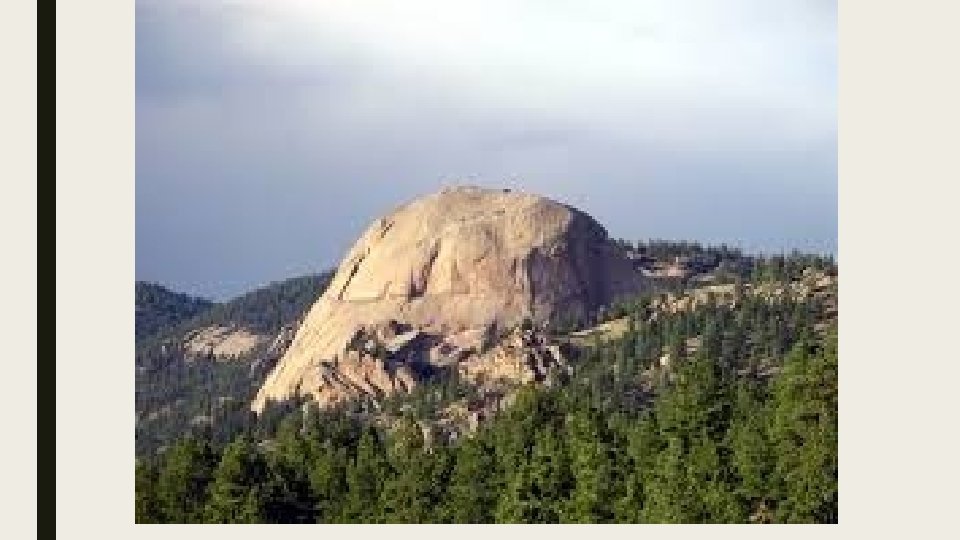
DOMES AND MONOLITHS ■ When large igneous intrusions are exposed. ■ Exposed through weathering of the earths surface,
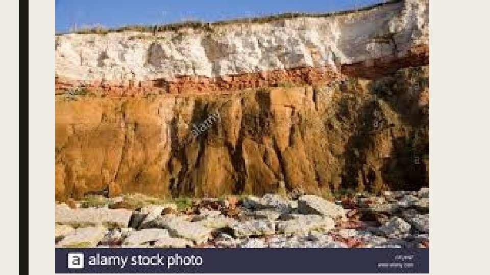
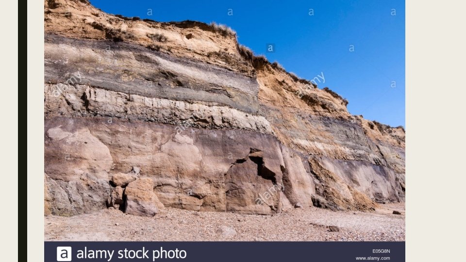
LANDFORMS ASSOCIATED WITH SEDIMENTRY ROCK ■ Deposited in horizontal layers then turn to rock called strata. ■ Some bands of strata are stronger than other bands ■ The stronger bands are more resistant in erosion. ■ Softer bands erode easily. ■ Different hardness helps produce landforms like mesa, buttes etc.
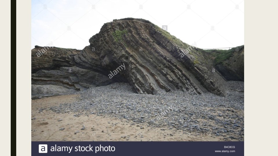
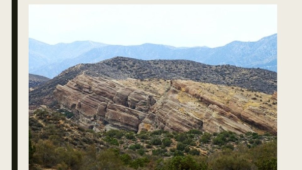
LANDFORM ASSOCIATED WITH INCLINED STRATA. ■ Sedimentary deposited at an angle at the edge of a continent as it slopes. ■ More than often it results from the movement of the Earth’s crust. ■ Deposited inclined erode to form a landform called a cuesta. ■ One steep slope and one gentle slope. ■ Scarp = slope and dip slope = gentle.
PLATE TECTONICS ■ A theory developed in the 60’s ■ Attempt to explain certain geological features were connected.
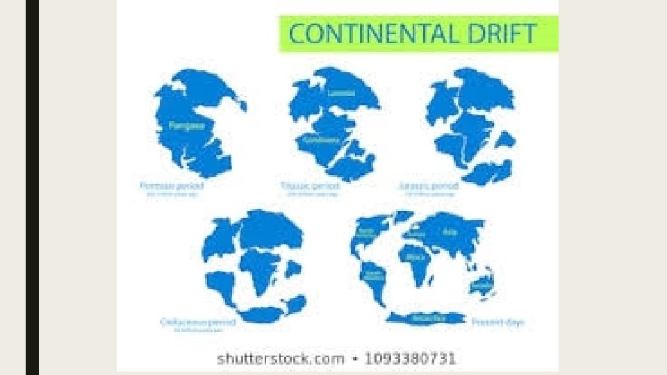
CHANGES IN THE POSITION OF THE CONTINENTS. ■ Alfred Wegner proposed a theory that the earths continents floated on the mantle. ■ Continental drift = suggest that continents were formed from one large landmass that slowly broke up
LARGE LANDMASS ■ PANGEA: One large landmass existed 180 million years ago ■ LAURASIA AND GONDWANALAND : broken up pieces of Pangea 175 million years ago. ■ Above mentioned started to split up about 150 to 65 million years ago.
EVIDENCE OF THE MOVEMENT OF CONTINENTS
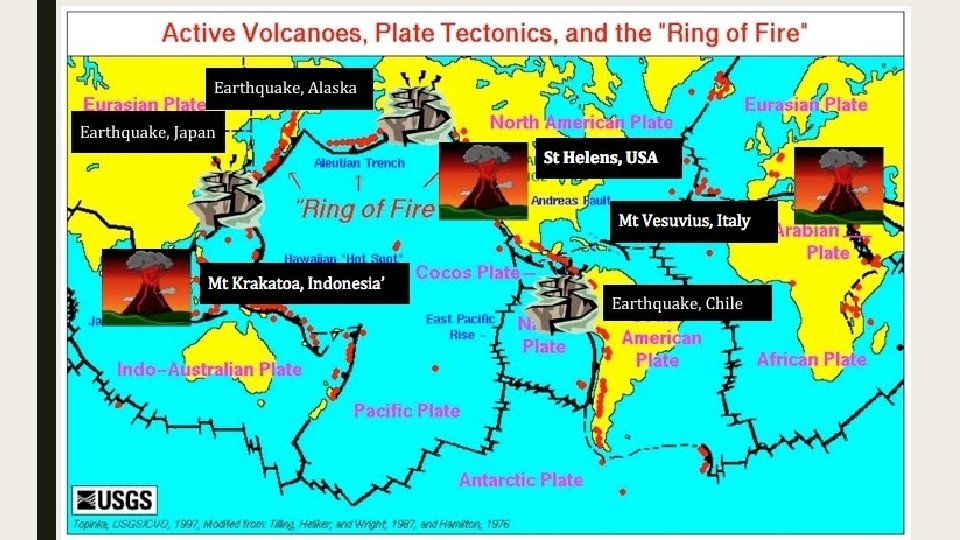
PLATE TECTONICS – explanation for the movement of continents. ■ New evidence in the 1960 s prove that the continents moved. ■ Movement example spreading of the sea-floor = complete theory plate tectonics. ■ Earthquakes, volcanoes, mountain building, folding and faulting.
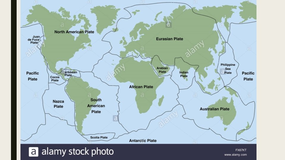
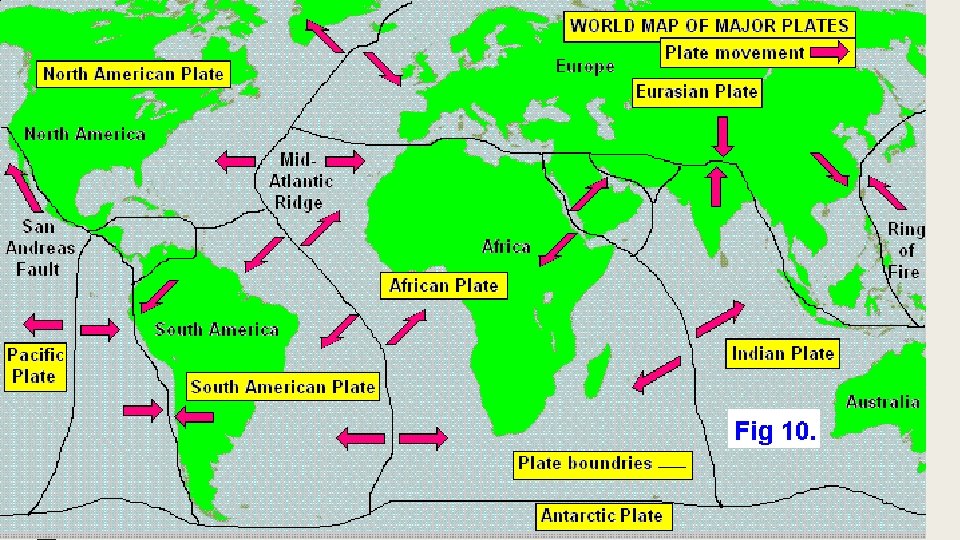
WHAT IS PLATE TECTONICS? ■ It’s a theory that divides the earths crust into 7 giant pieces called plate tectonics. ■ Most plates are made of continental crust and some oceanic crust. – moves a few cm a year ■ Forces in the mantle are believed to cause the movement. ■ Edges of the plates are called plate boundaries.
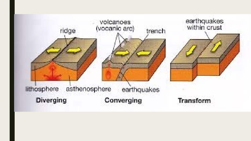
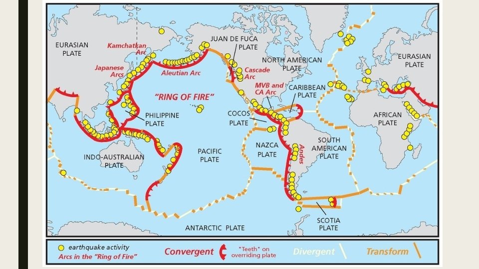
KINDS OF PLATE BOUNDARIES. ■ DIVERGENT BOUNDARIES ■ CONVERGENT BOUUNDARIES ■ TRANSFORM BOUNDARIES.
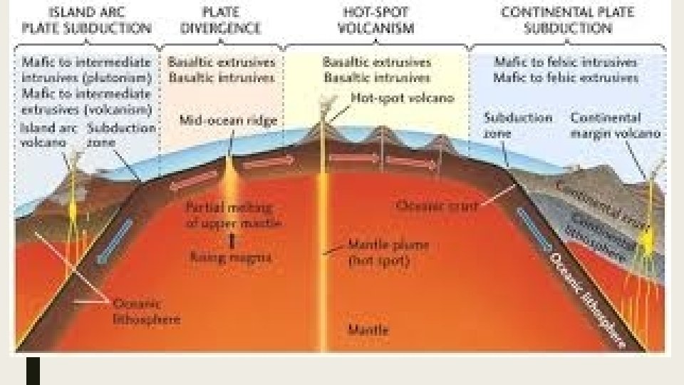
DIVERGENT BOUNDARIES ■ Where plates move away from the each other, ■ New crust is created from erupting volcanoes at divergent plate boundaries
CONVERGENT BOUNDARIES. ■ Where plates come together ■ One is formed under the other. ■ Plate melts causing earthquakes and volcanic eruptions.
TRANSFORM BOUNDARIES. ■ Plates grind past each other. ■ Usually associated with earthquakes.
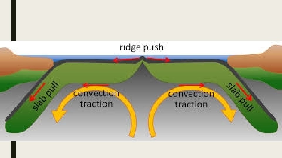
THE MECHANICS OF PLATE MOVEMENTS 1. The convection currents from above areas of high temperature in Earths mantle. 2. The high temperature set up convection currents in the mantle, causing the liquid mantle to move. 3. This movement drags the solid crust above the mantle in the direction of the convection current. 4. As the plates move apart, magma rises from the mantle and fills the gap between the two plates.
■ This shows how the earths surface is spreading and increasing. ■ And the convergent boundaries shows how the earths crust gets destroyed at the plate boundary
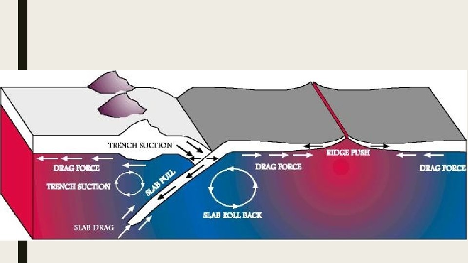
DESTRUCTION OF PLATES AT THE CONVERGENT ZONES. 1. Convection currents drag the denser oceanic plate under the lighter continental plate. 1. The sinking of an oceanic plate at a convergent boundary is called subduction. This is known as the subduction zone. 2. As the oceanic plate enters the mantle, it begins to bend and crack, forming trenches. 3. This process of subduction creates volcanic and earthquake activity, 4. Earthquakes tend to happen neat the trenches, volcanoes occur further inland on continental plates. 5. Volcanoes are triggered by the melting of the oceanic plate when
SIMPLIFY ■ New oceanic crust is created at the ridges under the oceans. ■ Oceanic plates moved by the convection currents under the mantle. ■ Descending convection currents drag the denser oceanic plate under the continental plate. ■ This get destroyed back into the mantle.
PROCESS AND LANDFORMS ASSOCIATED WITH PLATE BOUNDARIES. 1. Landforms associated with divergent plate boundaries. 2. Landforms associated with convergent plate boundaries. 3. Landforms associated with transform plate boundaries.
TWO KINDS OF DIVERGENT BOUNDARIES 1. BETWEEN TWO OCEAN PLATES. 2. WITHIN OCEANIC CRUST.
BETWEEN TWO OCEAN PLATE. ■ Mid oceanic ridge is the main feature of a divergent plate. ■ Volcanoes erupting at the plate boundaries create mid oceanic ridges. ■ Earthquake activity is also associated with this,
■ Mid Atlantic ridge is one of the longest chain of mountains in the world. ■ Divides north and south America and the African and Eurasian plate ■ Iceland was created from volcanic activity on the plate border of diverging plates
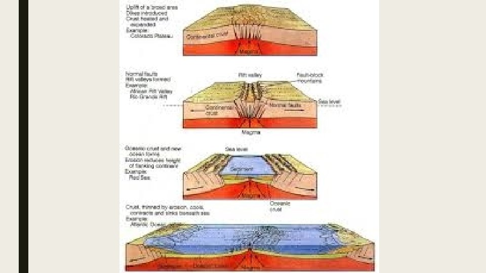
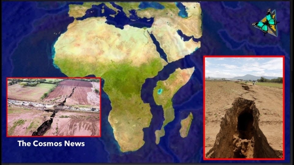
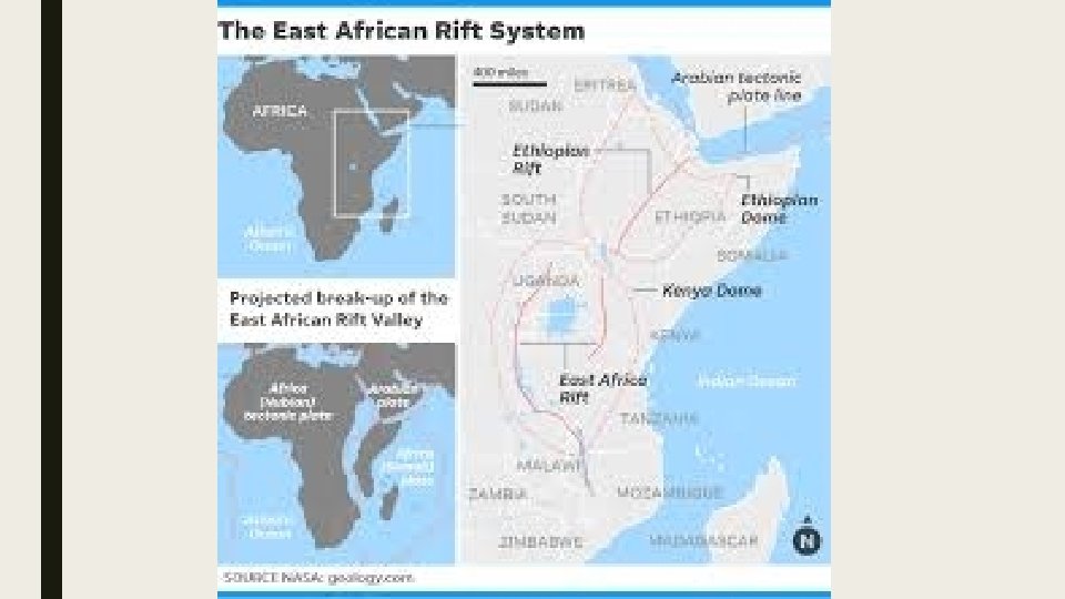
BETWEEN CONTINENTAL CRUST. ■ When continental crusts splits and separates, 2 continental plates will form. ■ New ocean crust will fill in the spaces. ■ East African Rift Valley. Parts of the African continent starting to rift apart.
HOW PLATE BOUNDARIES FORM UNDER CONTINENTAL CRUST. 1. Convection currents within the mantle allow a plume of magma to push under the continental crust. this causes the crust to crack.
2. Further upward pressure and rocks to fall in the centre. side wards moving causes this process is called rifting. volcanoes erupt around new plate boundaries causing new crust.
3. The land masses continue to move apart and new crust fills the gap between eventually new ocean will fill gap. the
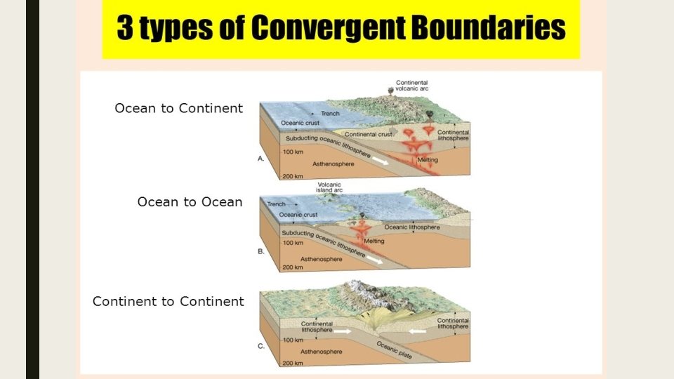
LANDFORMS ASSOCIATED WITH CONVERGENT PLATE BOUNDARIES 1. A convergent plate boundary between two ocean plates. 2. Convergent plate boundary between an ocean plate and continental plate 3. A convergent plate boundary between two continental plates
1. CONVERGENCE BETWEEN TWO OCEAN PLATES. ■ Two ocean plates converge one plate is pushed under the other. ■ This creates volcanoes.
2. BETWEEN OCEAN PLATE AND CONTINENTAL PLATE. ■ Oceanic plate is pushed under the continental plate. ■ Mountain ranges might form
PROCESS 1. Oceanic crust is denser than continental crust because of material deposits. 2. Enters the subduction zone cracks and bends causing a deep sea trench. Further subduction may cause earthquakes. 3. Melting of the oceanic plate causes igneous activity. 1. Volcanoes may erupt on continental plates.
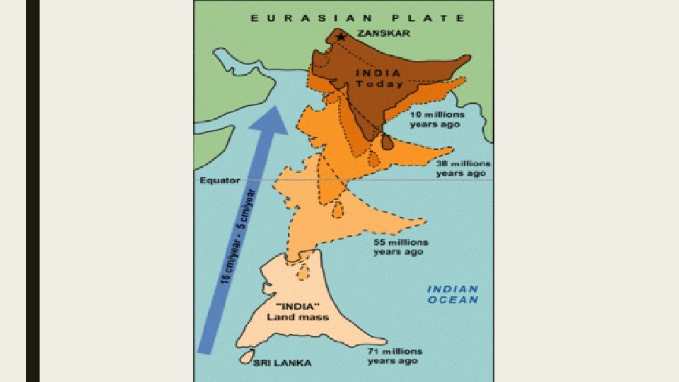
BETWEEN TWO CONTINENTAL PLATES. ■ Neither plate can subduct. ■ This is because they are made up of the same material. ■ Collision and crust creates mountains. ■ The Himalayas
PROCESS 1. Converging crust cannot subduct = bends and cracks and push upwards or sidewards 2. Mountains build up where plates collide. 3. As they converge a plateau may develop behind the mountains.
TRANSFORM BOUNDARY. ■ Neither created or destroyed at this boundary. ■ It simply grinds past one another. ■ Most are found under the ocean ■ This movement causes earthquakes.
WORLDS VOLCANIC AND EARTHQAUKE ZONE. ■ Earth’s crust is constantly moving. ■ Therefore accompanied by earthquakes. ■ At 50 earthquakes recorded per a day. ■ Most are minor. ■ 50 eruptions a year. ■ 2000 active or partially active volcanoes that could erupt.