The SPC Severe Thunderstorm Database SPC Database Derivation

The SPC Severe Thunderstorm Database

SPC Database Derivation WFO Storm. Dat Info NWS/ OCWWS/ Verification Apr. /May next year due to 60 day lag & Quality Control SPC NCDC ONETOR FTORNADO

SPC Severe Thunderstorm DATABASE A Severe Thunderstorm is a thunderstorm that produces a tornado, winds of at least 50 knots (58 mph), and or hail at least 0. 75 inch in diameter. Structural wind damage may imply the occurrence of a severe thunderstorm. Tornadoes since January 1, 1950 Wind and Hail since January 1, 1955

SPC Data Source Since 1972… data agrees with NOAA Storm Data. Prior to 1972… • tornado data -- from Storm Data (or its predecessor Climatological Data National Summary - Storm Data and Unusual Phenomena) • wind and hail data --from real time information collected by the U. S. Air force. Errors corrected when identified (if possible) 1972 Wind & Hail data incomplete

Uniqueness of SPC Tornado Database • SPC Tornado Database is EVENT based • NCDC (Ashville) Database is SEAGMENT based For 1950 - 2001: SPC had 43, 467 tornadoes NCDC had 46, 472 tornado segments

What is a tornado Segment? • Pre-1996 – Enter/left a county with fatality/injury – Crossed a State boundary • Since 1996 Sep 20, 2002 Indiana Tornadoes Tornado #1 = 3 segments Tornado #2 = 9 segments – Tornado segments are divided by counties and States – When tornado makes “sharp turns” within a county in order to adequately describe the path

Example of Tornado Segments 4 3 2 1

Tornadoes v. Tornado Segments 1950 -2001
 State")
SPC Database Fields – – – – – – Year Number (by State) State Month Day Date Time (CST) Tornado Number No-States State-Tornado number Segno (1=entire tornado, 2 = state portion) STLAT/STLON SPLAT/SPLON Length Area F*Area Width (Max) Fatal Injuries Damage CO (1 -4) F PL PW

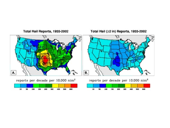
SPC Severe Thunderstorm Wind & Hail Report Database 68, 612 Hail reports back through 1955 Reports within one county must be separated by 10 miles or 15 minutes if less than 65 kts and did not cause deaths or injuries or did less than $500 K damage 203, 698 Wind back through 1955 Reports within one county must be separated by 10 miles or 15 minutes if smaller than 2” and did not cause deaths or injuries or did less than $500 K damage Format similar to Tornado Database, except F is relplaced by diameter (hundredths of inches) or wind speed (knots). Other tornado related fields are left blank.

Severe Thunderstorm Reports

F-Scale Evaluation “The tornado first touched down on the eastern edge of General Smallwood State Park just north of Rison. It pushed east-southeast and passed just south of Pisgah where it grew to F 2 strength. The tornado moved through Mount Pisgah and damaged homes on Ripley Road between Ripley and Garden Estates. The twister continued to move east through rural lands south of Hawthorne Road (Route 255) passing just north of the community of Graystone. Next, it moved through the communities of Habre de Venture, Longmeade, Clamber Hill, Hawthorne Manor, and Hillendale about 3 miles west of downtown La Plata. The tornado, now F 3 strength, hit the western portion of La Plata next, moving directly through the neighborhoods of Valley View, Morgan's Ridge, Quailwood, and Haldane. The tornado, now F 4 strength, continued east into the downtown area where it crossed through the intersection of Route 301 and 6. Damage was found on either side of F-Scale misinterpreted in describing This tornado Route 6 iswith the most severe devastation tornado occurringstrength. on the south side isofcausing more damage rather than gaining strength! Little the highway. ” description of the tornado itself! How is it known the winds became stronger?

United States Tornadoes

F-Scale Percentages 1950 - 2001 Number Deaths


Which is the F 5 Tornado? F 5 F 2 Oklahoma City, OK Burkburnett County, TX May 3, 1999 March 7, 2002 Symposium on F-Scale and Severe-Weather Assessment


Manhatten, KS May 31, 1948 F-2 Length – 20 km Width – 130 m Seymour, TX April 10, 1979 F-2 Length – 17 km Width – 300 m


Grand Gulf, MS April 17, 1978 F-3


Fall Velocity ~ 120 mph

3/4" and Larger Hail Reports

© Bill Bunting

Severe Thunderstorm Wind Reports
 Gusts")
Severe Thunderstorm Wind Reports 1955 -2001 Gusts > 58 mph Thunderstorm(>75 Wind mph) Gusts > 75 mph Damage Only Thunderstorm Wind Percent of Wind Reports from

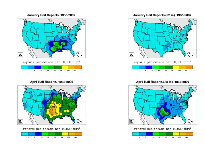
January Thunderstorm Wind Reports Thunderstorm Gusts > 75 mph January Thunderstorm Gusts > 58 mph January April Thunderstorm Wind Reports Thunderstorm Gusts > 75 ph April Thunderstorm Gusts > 58 mph April

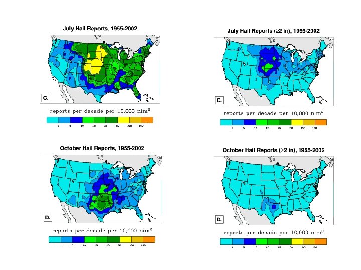
July Thunderstorm Wind Reports Thunderstorm Gusts > 75 mph October Thunderstorm Wind Reports Thunderstorm Gusts > 75 mph July Thunderstorm Gusts > 58 mph October Thunderstorm Gusts > 58 mph July October

© K. Dewey, High Plains Regional Climate Center Hallam, NE – May 22, 2004, 2 ½ miles wide
- Slides: 43