The South American Monsoon System Recent Evolution and
- Slides: 22

The South American Monsoon System: Recent Evolution and Current Status Update prepared by Climate Prediction Center / NCEP 28 November 2008 For more information, visit: http: //www. cpc. ncep. noaa. gov/products/Global_Monsoons/American_Monsoons

Outline • Highlights • Recent Evolution and Current Conditions • NCEP/GFS Model Forecasts • Climatology

Highlights • Even though rainfall over the monsoon region has increased, the monsoon rainfall is still lagging behind the long-term average over most of the monsoon core region, with long-term (90 -day) rainfall deficits exceeding 100 mm in many areas. • The heavy rains in Santa Catarina, Brazil during the past week were associated with an unusually intense high pressure system over the western South Atlantic that created a very strong onshore pressure gradient. Those conditions favored upward motion along the Sierra do Mar, which was enhanced by the 500 -h. Pa trough. See slides 7 to 17.

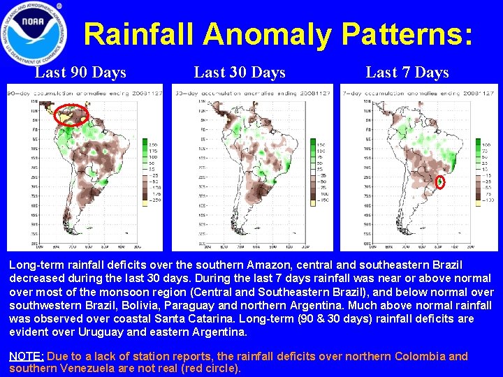
Rainfall Anomaly Patterns: Last 90 Days Last 30 Days Last 7 Days Long-term rainfall deficits over the southern Amazon, central and southeastern Brazil decreased during the last 30 days. During the last 7 days rainfall was near or above normal over most of the monsoon region (Central and Southeastern Brazil), and below normal over southwestern Brazil, Bolivia, Paraguay and northern Argentina. Much above normal rainfall was observed over coastal Santa Catarina. Long-term (90 & 30 days) rainfall deficits are evident over Uruguay and eastern Argentina. NOTE: Due to a lack of station reports, the rainfall deficits over northern Colombia and southern Venezuela are not real (red circle).

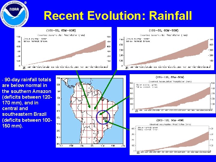
Recent Evolution: Rainfall - 90 -day rainfall totals are below normal in the southern Amazon (deficits between 120170 mm), and in central and southeastern Brazil (deficits between 100150 mm). BP

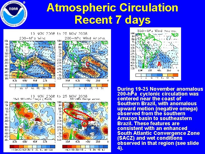
Atmospheric Circulation Recent 7 days C A • During 19 -25 November anomalous 200 -h. Pa cyclonic circulation was centered near the coast of Southern Brazil, with anomalous upward motion (negative omega) observed from the southern Amazon basin to southeastern Brazil. These features are consistent with an enhanced South Atlantic Convergence Zone (SACZ) and wet conditions observed in that region (see slide 4).

Circulation Features over South America Accompanying the Heavy Rains over Santa Catarina, Brazil

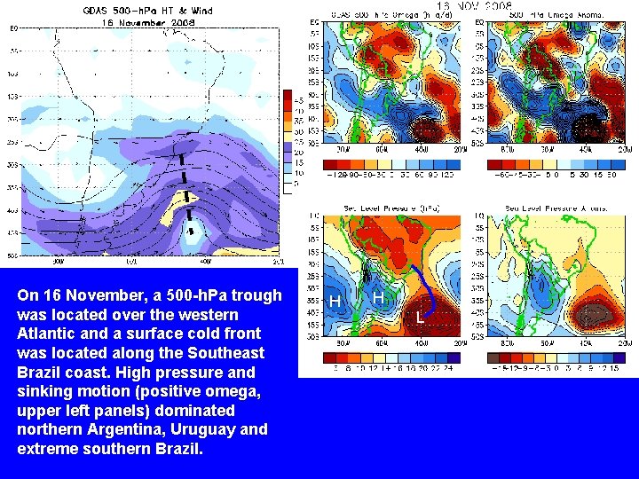
On 16 November, a 500 -h. Pa trough was located over the western Atlantic and a surface cold front was located along the Southeast Brazil coast. High pressure and sinking motion (positive omega, upper left panels) dominated northern Argentina, Uruguay and extreme southern Brazil. H H L

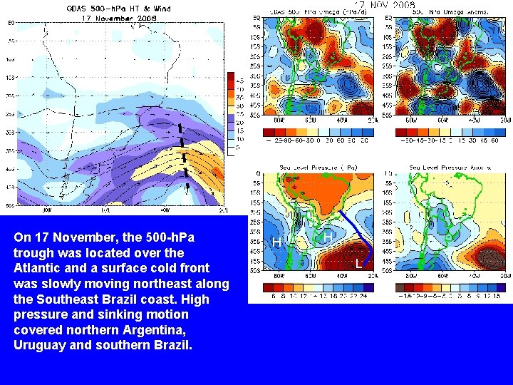
On 17 November, the 500 -h. Pa trough was located over the Atlantic and a surface cold front was slowly moving northeast along the Southeast Brazil coast. High pressure and sinking motion covered northern Argentina, Uruguay and southern Brazil. H H L

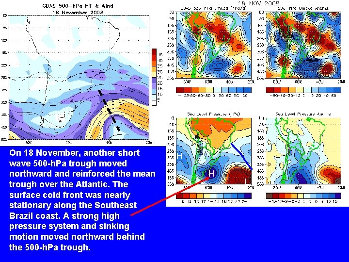
On 18 November, another short wave 500 -h. Pa trough moved northward and reinforced the mean trough over the Atlantic. The surface cold front was nearly stationary along the Southeast Brazil coast. A strong high pressure system and sinking motion moved northward behind the 500 -h. Pa trough. H H L

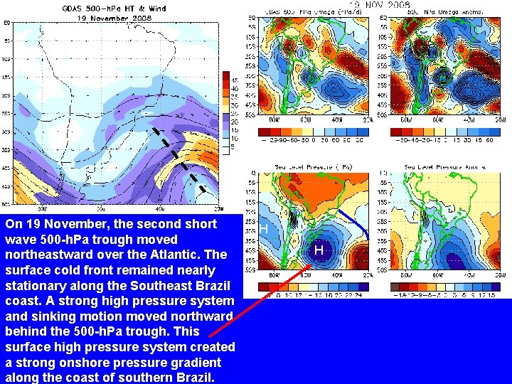
On 19 November, the second short wave 500 -h. Pa trough moved northeastward over the Atlantic. The surface cold front remained nearly stationary along the Southeast Brazil coast. A strong high pressure system and sinking motion moved northward behind the 500 -h. Pa trough. This surface high pressure system created a strong onshore pressure gradient along the coast of southern Brazil. H H

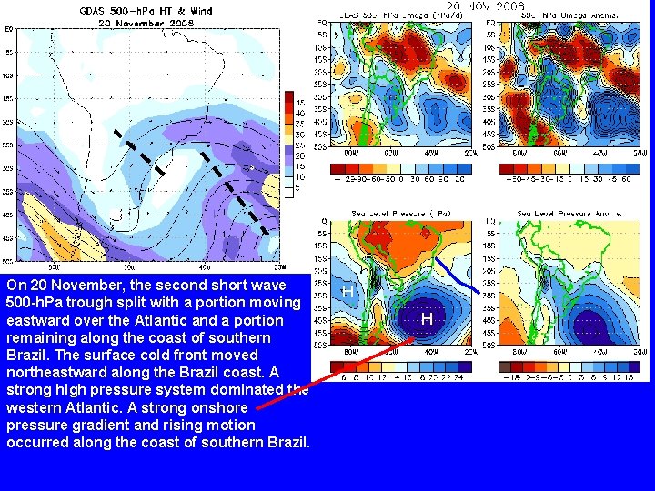
On 20 November, the second short wave 500 -h. Pa trough split with a portion moving eastward over the Atlantic and a portion remaining along the coast of southern Brazil. The surface cold front moved northeastward along the Brazil coast. A strong high pressure system dominated the western Atlantic. A strong onshore pressure gradient and rising motion occurred along the coast of southern Brazil. H H

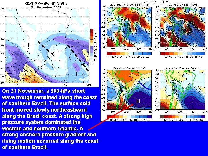
On 21 November, a 500 -h. Pa short wave trough remained along the coast of southern Brazil. The surface cold front moved slowly northeastward along the Brazil coast. A strong high pressure system dominated the western and southern Atlantic. A strong onshore pressure gradient and rising motion occurred along the coast of southern Brazil. H

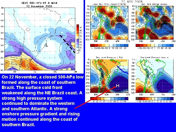
L On 22 November, a closed 500 -h. Pa low formed along the coast of southern Brazil. The surface cold front weakened along the NE Brazil coast. A strong high pressure system continued to dominate the western and southern Atlantic. A strong onshore pressure gradient and rising motion continued along the coast of southern Brazil. H

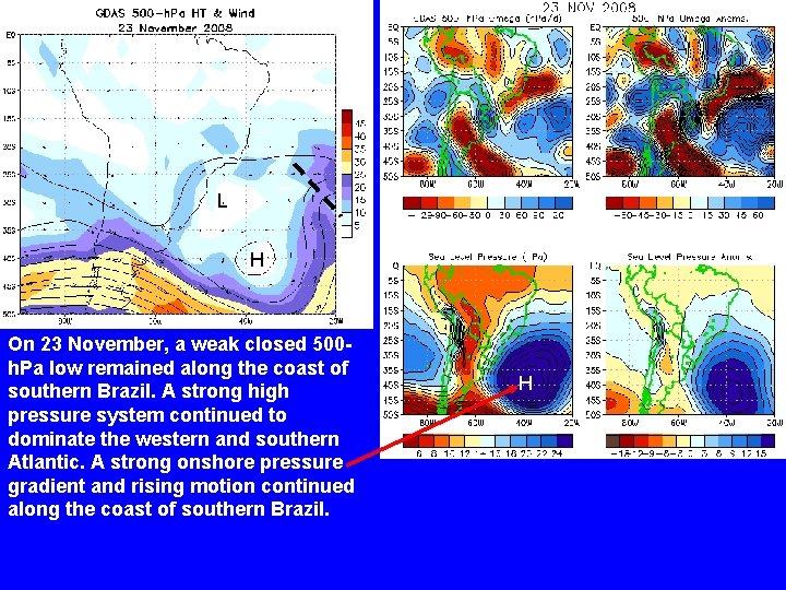
L H On 23 November, a weak closed 500 h. Pa low remained along the coast of southern Brazil. A strong high pressure system continued to dominate the western and southern Atlantic. A strong onshore pressure gradient and rising motion continued along the coast of southern Brazil. H

• The heavy rains in Santa Catarina, Brazil were associated with an unusually intense high pressure system over the western South Atlantic that created a very strong onshore pressure gradient. Those conditions favored upward motion along the Sierra do Mar, which was enhanced by the 500 -h. Pa trough.

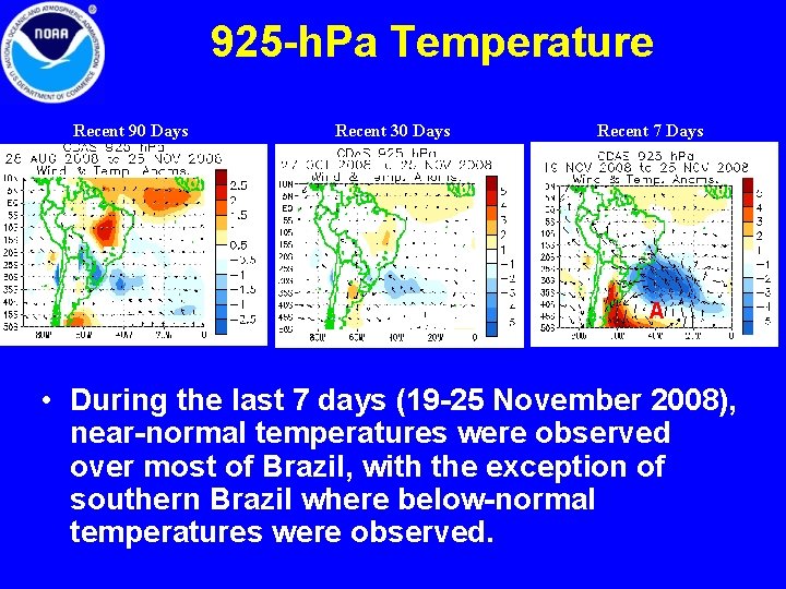
925 -h. Pa Temperature Recent 90 Days Recent 30 Days Recent 7 Days A • During the last 7 days (19 -25 November 2008), near-normal temperatures were observed over most of Brazil, with the exception of southern Brazil where below-normal temperatures were observed.

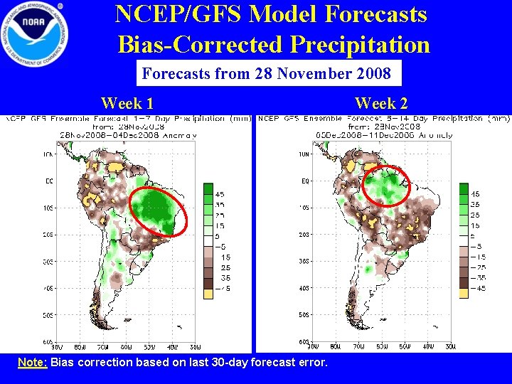
NCEP/GFS Model Forecasts Bias-Corrected Precipitation Forecasts from 28 November 2008 Week 1 Note: Bias correction based on last 30 -day forecast error. Week 2

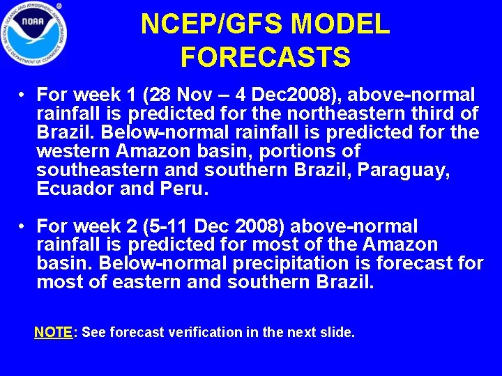
NCEP/GFS MODEL FORECASTS • For week 1 (28 Nov – 4 Dec 2008), above-normal rainfall is predicted for the northeastern third of Brazil. Below-normal rainfall is predicted for the western Amazon basin, portions of southeastern and southern Brazil, Paraguay, Ecuador and Peru. • For week 2 (5 -11 Dec 2008) above-normal rainfall is predicted for most of the Amazon basin. Below-normal precipitation is forecast for most of eastern and southern Brazil. NOTE: See forecast verification in the next slide.

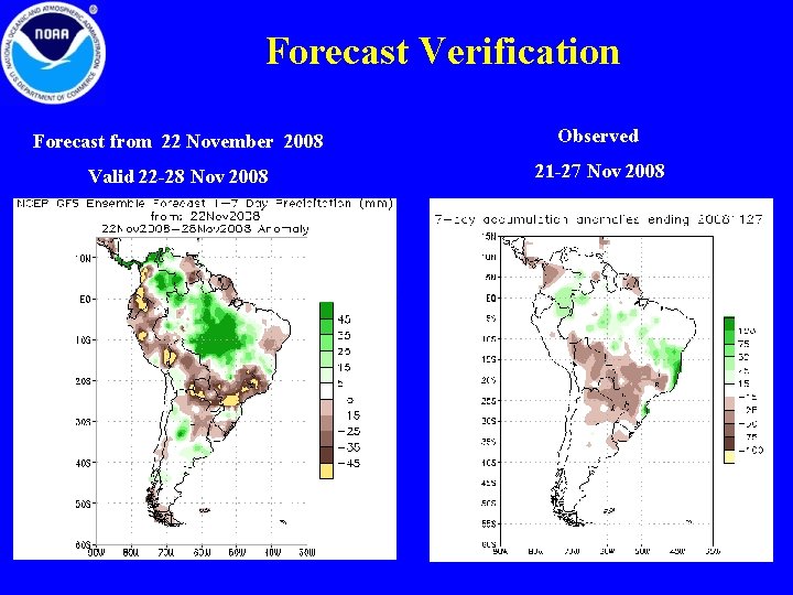
Forecast Verification Forecast from 22 November 2008 Observed Valid 22 -28 Nov 2008 21 -27 Nov 2008

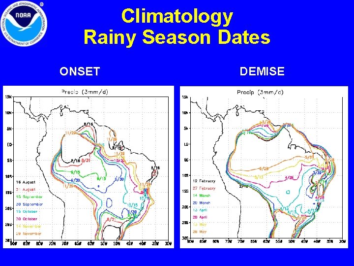
Climatology Rainy Season Dates ONSET DEMISE

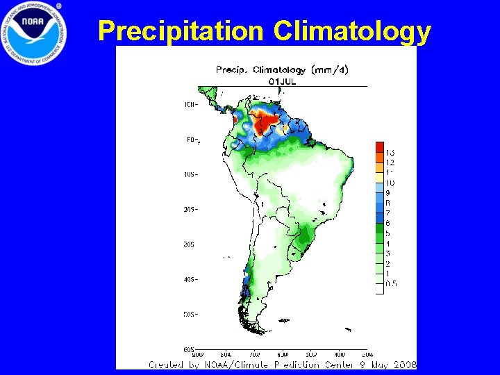
Precipitation Climatology