The Physical Geography of Mexico Ch 7 1


- Slides: 27
The Physical Geography of Mexico Ch. 7. 1
Warm-up 1. What are some physical characteristics of Chiapas? 2. Why are there no roads through the Lacandon forest in Chiapas? 3. What are some of the human-made changes happening in Chiapas?
Answers 1. The region contains countless different plants and animals. The scenery is beautiful, and the landscape is ever-changing. Most of the landscape is countryside. 2. The undergrowth is so dense it has been impossible to build a road through it. 3. Many trees are being cut down for power lines, to provide timber, and to clear land for large-scale agriculture.
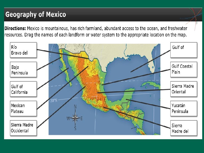
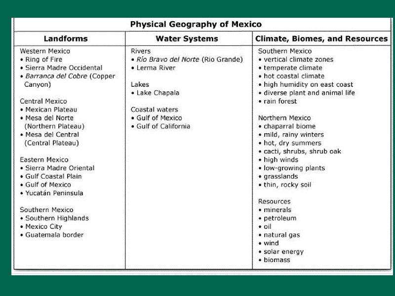
Physical Geography of Mexico Landforms • Mexico, along with Central America, joins the continents of North America and South America with a physical feature called a land bridge. • A land bridge is a strip of land that connects two larger landmasses, enabling migration of plants and animals to both areas. • There a variety of landforms in Mexico that support large communities of people. • The western side of Mexico is part of the Ring of Fire, a hotspot of seismic activity.
Mexico, along with Central America, joins the continents of North America and South America with a physical feature called a land bridge.
A land bridge is a strip of land that connects two larger landmasses, enabling migration of plants and animals to both areas.
Sierra Madre Mts. In Mexico. Occidental, Oriental and del Sur
Mexican Plateau- where most people live b/c mild, fertile and rainfall
The western side of Mexico is part of the Ring of Fire, a hotspot of seismic activity.
Color code your map 1
Physical Geography of Mexico Water Systems • Northern Mexico has a dry climate with few permanent waterways. • The Lerma River is one of Mexico's most important rivers. • The Gulf of Mexico, along Mexico's east coast, is home to a wide variety of sea life. • The Gulf of California, on the western side of Mexico, supports marine life such as whales, sea turtles, and sharks.
Northern Mexico has a dry climate with few permanent waterways.
The Lerma River is one of Mexico's most important rivers.
Rio Bravo de la Norte or the Rio Grande River- important
Lake Chapala- one of the few lakes in Mexico
The Gulf of Mexico, along Mexico's east coast, is home to a wide variety of sea life.
Yucatan Peninsula-popular tourist destination
The Gulf of California, on the western side of Mexico, supports marine life such as whales, sea turtles, and sharks.
Physical Geography of Mexico Climate, Biomes, and Resources • Three factors that influence Mexico's climates are regional high-pressure systems, northeast trade winds, and vertical climate zones. • Vertical climate zones occur as elevations increases. • Mexico has a variety of biomes that support various plant and animal life. • Minerals, especially silver, are important to Mexico's economy. • Mexico is a leading petroleum-producing country.
Three factors that influence Mexico's climates are regional high-pressure systems, northeast trade winds, and vertical climate zones.
Vertical climate zones occur as elevations increases.
Mexico has a variety of biomes that support various plant and animal life.
Minerals, especially silver, are important to Mexico's economy.
Mexico is a leading petroleum-producing country.
Answers to question pg. 197 1. The higher you go in elevation, the colder it gets affecting the types of crops you grow. 2. Lerma R. - 1 of most important- feeds Lake Chapala, Mexico’s largest natural lake. Balsas R. - steep & swift= hydroelectric power Gulf of Mexico- fishing industry Rio Grande- border b/w US and largest river outside central Mexico 3. Mexican Plateau- largest & densely populated region/ most food grown 4. Northern Mexico= dry climate so permanent waterways rare 5. Farmers on Central Plateau rely on climate to have enough water for crops