The Ocean Floor The landscape and landforms of


 descent of a continental shelf to the ocean floor Begins")


- Slides: 50
The Ocean Floor The landscape and landforms of the ocean floor
Students will be able to describe and explain the composition, properties, and structures of the oceans’ zones, layers, and landforms and how it relates to the compositions and interactions between the Earth’s structure and its atmosphere. Learning Goal
The topography of the ocean is more varied and with larger elevation changes than on the Earth’s surface. https: //youtu. be/K-UXrp. Ajyl 0
Oceanography The branch of science that deals with the physical and biological properties and phenomena of the sea
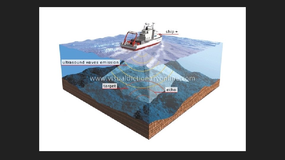
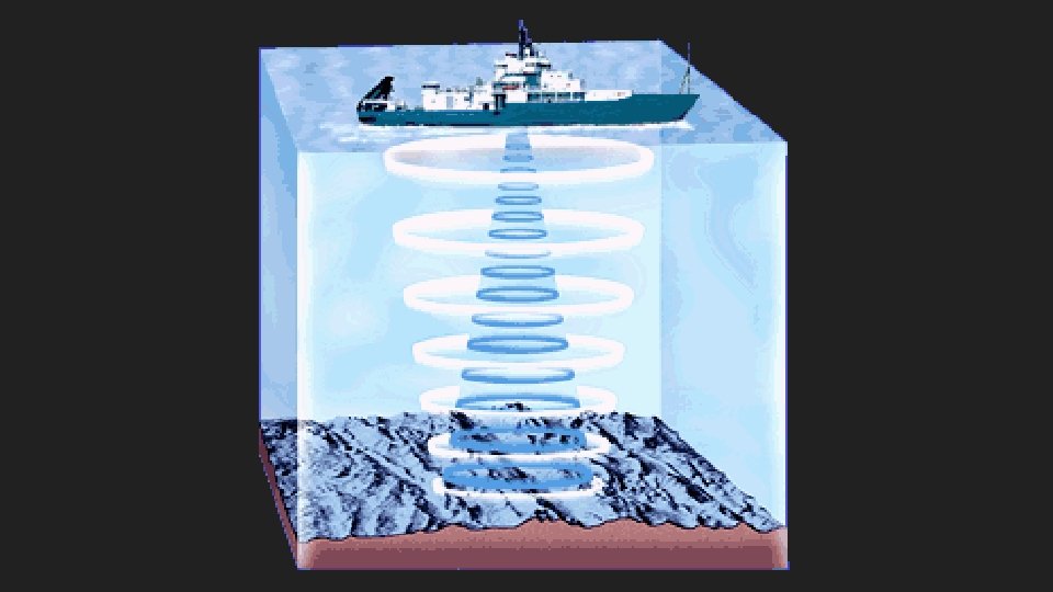
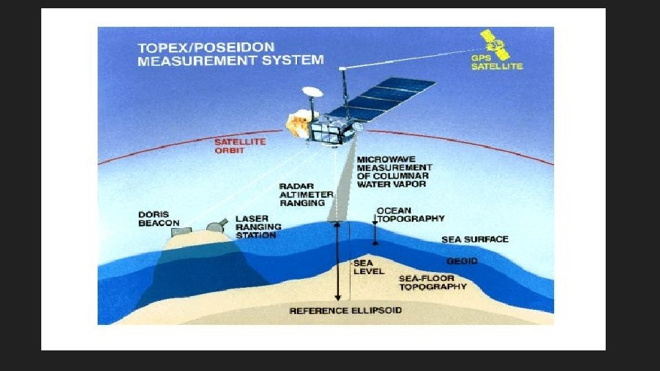
Studying the Ocean Floor Sonar – Echo Sounding – Satellite –
Sonar Sound Navigation and Ranging Scientists send sound waves to the bottom of the ocean by ship. The sound waves bounce off the ocean floor and return to the ship. The deeper the ocean, the longer it takes for the sound waves to return. Measures water depth
Echo Sounding Shapes can be determined by measuring the time it takes for the sound to “bounce back” Some marine life also uses this method.
Satellites send images to Earth that measure direction and speed of ocean waves
Seasat was the first Earth-orbiting satellite designed for remote sensing of the Earth's oceans and had on board the first spaceborne synthetic aperture radar. https: //eospso. gsfc. nasa. gov/missions/seasat-1
Geosat Military satellite Measures height of the ocean surface. Different underwater features affect the height of the water above them. https: //science. nasa. gov/missions/geosat
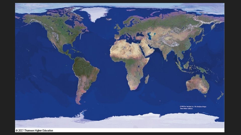
How do earth landforms compare with ocean landforms? https: //www. nationalgeographic. org/encyclopedia/landform/
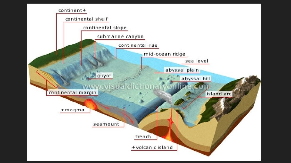
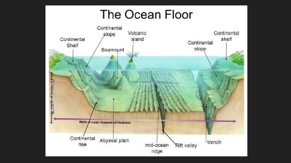
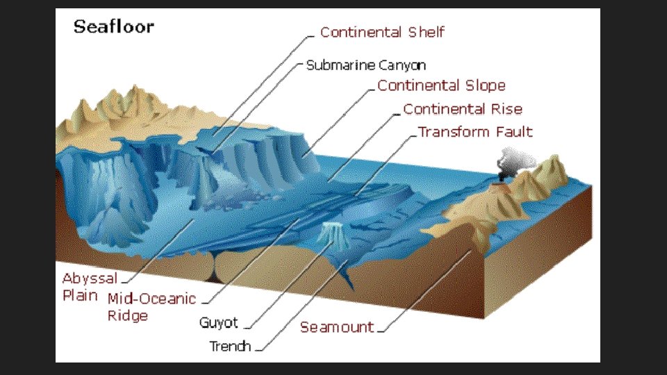
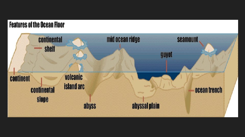
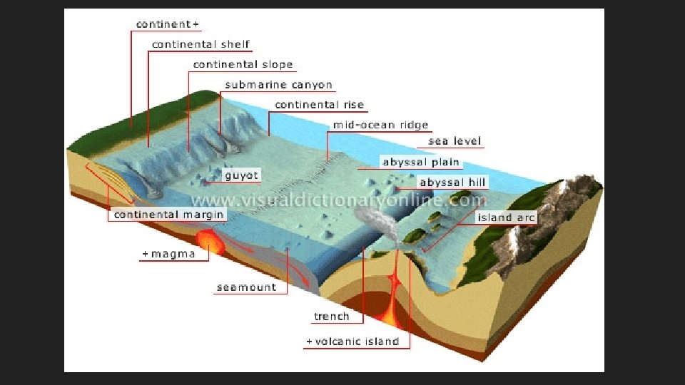
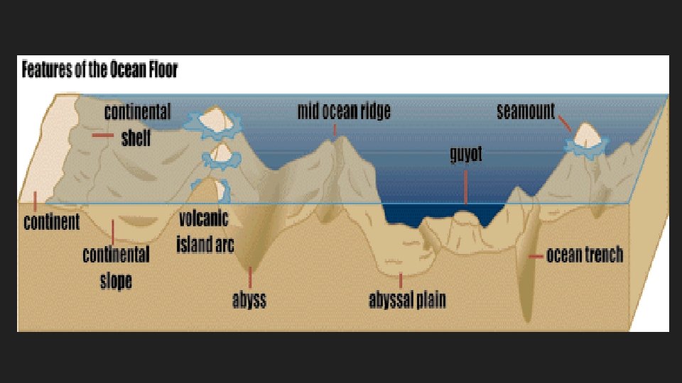
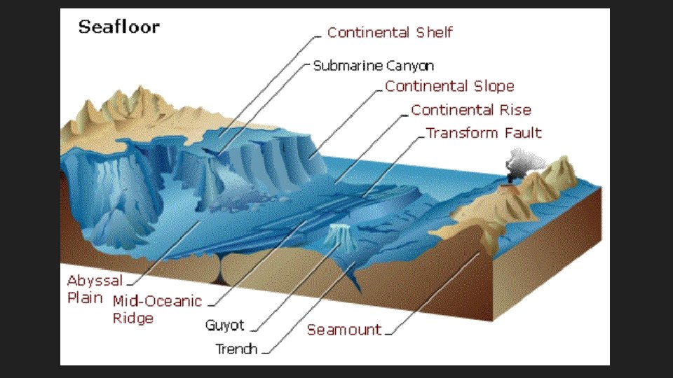
continent sea mount continental shelf continental slope rift valley trench abyssal plain continental rise mid-ocean ridge
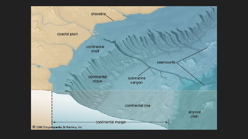
Features of the Ocean Floor Continent/Land Shore/Shoreline Continental Margin • Continental Shelf • Continental Slope • Continental Rise Deep Ocean Basin • Seamounts • Abyssal Plain • Mid-ocean ridge • Rift valley • Volcanic Islands • Ocean Trench
Continent Land mass area not under water Seven continents on Earth
Shore/Shoreline A narrow, gently sloping strip of land that lies along the edge of an ocean A beach, a coastline
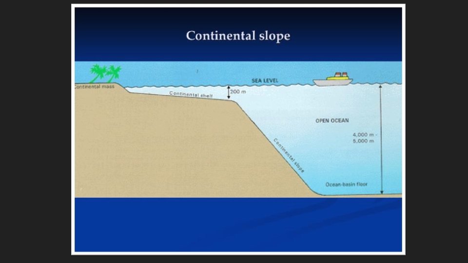
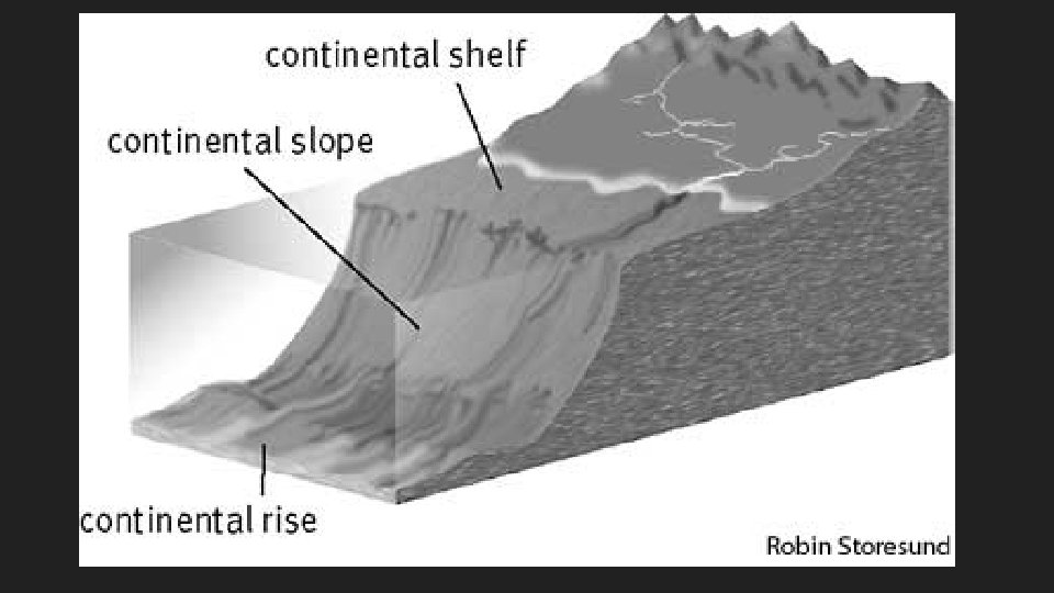
Continental Shelf Part of a continent that extends underwater to the deep-ocean floor Begins at the shoreline Continues until the ocean floor starts to slope
Continental Slope The (sometimes-steep) descent of a continental shelf to the ocean floor Begins at edge of continental shelf Continues down to the flat part of the ocean floor
Continental Rise Large piles of sediment at the base of the continental slope
Continental Margin Made up of • Continental shelf • Continental slope • Continental rise
Continental Margin
Deep Ocean Basin Made up of • Seamounts • Abyssal plain • Mid-ocean ridge • Rift valleys • Volcanic Islands • Ocean trenches
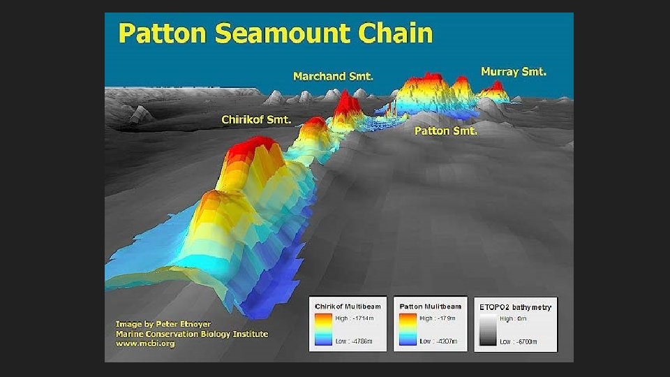
Seamounts Underwater mountains made of volcanic material Formed when magma pushes it way through or between tectonic plates If seamounts build up they can become volcanic islands; Example: Hawaiian Islands Seamounts are usually 25 miles (40 kilometers) in diameter and can be 10, 000 to 15, 000 feet (3000 to 4500 meters) tall.
Seamounts Less than 0. 1 percent of the world's seamounts have been explored to learn what species live on them, but many of the species that have been found so far are new to science. It has been estimated that more than 30, 000 seamounts reaching more than 1, 000 meters tall are found in the Pacific Ocean. Approximately 800 are in the Atlantic Ocean, and an unknown number exist in the Indian Ocean.
Abyssal Plain Huge, flat, sediment-covered areas of the deep ocean floor o Covered in mud and remains of tiny marine organisms o Occur in depths 6500 m below sea level or lower
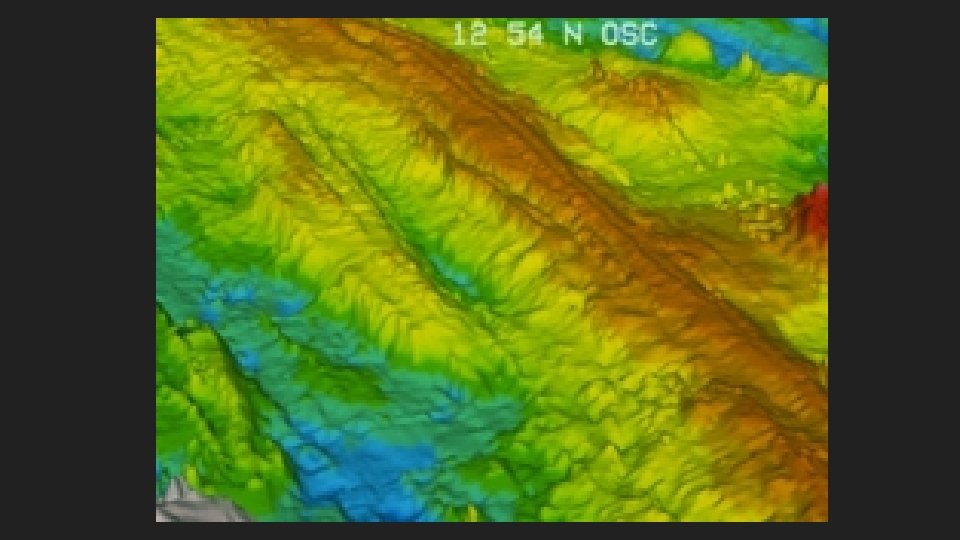
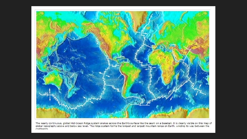
Mid-Ocean Ridge Underwater mountain ranges, formed by plate tectonics Rising magma between the plates creates the ridge http: //oceanexplorer. noaa. gov/explorations/05 galapagos/backgr ound/mid_ocean_ridge. html
Rift Valley A lowland in the ground caused by the seafloor spreading apart. https: //www. nationalgeographic. org/encyclopedia/riftvalley/ Hydrothermal vents were discovered in rift valleys. https: //oceanservice. noaa. gov/facts/vents. html
Volcanic Islands An island that was made from volcanoes erupting from the ocean floor An island is a solitary mountain formed by volcanic activity. Lava erupting from the sea floor builds up on the sea bed over thousands, or even millions of years. The lava cools rapidly as it reaches the ocean water and forms solid rock. Each eruption of the sea floor volcano builds up the volcano a little bit higher. Until one day, the eruptions have built the top of the undersea mountain so high, that it rises above the ocean’s surface.
http: //www. cnn. com/videos/world/2015/02/28/pkg-orig-volcano-forms-new-island -japan. cnn https: //oceantoday. noaa. gov/deepoceanvolcanoes/
Ocean Trench A long, deep depression in the ocean floor Huge cracks on ocean floor Created by oceanic plate pushing beneath continental plate or another oceanic plate Deep-sea trenches are the deepest parts of the ocean. https: //www. nationalgeographic. org/encyclopedia/ocean-trench/
Ocean Trench The deepest one, the Marianas Trench in the South Pacific Ocean, is more than 35, 000 feet (10, 668 meters), or almost 6. 6 miles (10. 6 kilometers) deep. A Navy-owned submarine, the Trieste, still holds the record for diving to the bottom of the deepest part of the Marianas Trench, the Challenger Deep, on January 23, 1960. https: //youtu. be/Y 2 tm 40 u. Mh. DI
continent sea mount continental shelf continental slope rift valley trench abyssal plain continental rise mid-ocean ridge